The Malibu Creek State Park Redwoods Are Dying

Century Lake, Malibu Creek State Park. March 26, 2016.

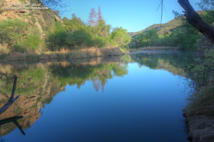
Illuminated by a just-risen sun, Goat Buttes reflected sharply on the lake’s surface. Ducks squabbled near some reeds and a bullfrog’s resonant croaking filled the canyon.

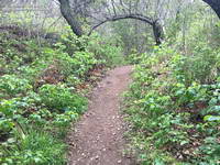
Part way through the Bulldog Loop, I’d paused for a moment at Century Lake in Malibu Creek State Park to enjoy the tranquility of the early morning. I snapped a photo and then noticed something very disturbing. The hundred year old coast redwoods across the lake looked brown.

Dying coast redwoods at Century Lake in Malibu Creek State Park. March 26, 2016.
Dying coast redwoods at Century Lake in Malibu Creek State Park

I tried to convince myself it was just the golden hue of the warm morning light, but it wasn’t. From Crags Road I could see at least one tree appeared to be dead, and most of the others were highly-stressed, if not dying. A detour to the other side of the lake on the Forest Trail confirmed the bleak situation.

Dead coast redwood at Century Lake in Malibu Creek State Park. March 26, 2016.
Dead coast redwood at Century Lake

Although coast redwoods have been planted in several areas of Southern California, they do not occur naturally here. The southernmost stand of naturally-occurring coast redwoods is about 200 miles north of Malibu Creek State Park in the Southern Redwood Botanical Area of Las Padres National Forest.

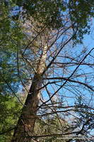
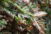
Redwoods have widespread, but shallow, root systems. Drought and warming temperatures are a worst case scenario for these trees, with the upper layer of soil being moisture-starved and baked.

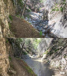
The redwoods appeared to be healthy in June 2011, August 2012, and January 2013. This photo was taken December 13, 2014 and may show the first hint of discolored and thinning foliage. On May 1, 2015 — just 4 1/2 months later — Google Earth imagery clearly shows several discolored trees.

This coast redwood along the Forest Trail shows some foliage discoloration, but is in better shape than the trees closer to Century Lake.
This redwood is in better condition than those along the shore of Century Lake.

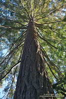
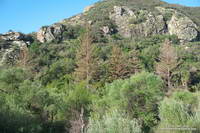
Ironically the redwoods closest to the lake appear to be the most severely affected. This tree away from the lake on the Forest Trail appears to be in better shape, but it too is showing signs of stress.

Malibu Creek State Park isn’t the only locale in Southern California where redwoods are dying. According to this May 2015 San Gabriel Valley Tribune article, 15 redwoods were removed from Verdugo Park in Glendale, and redwoods in other areas of Southern California have also been affected.

Browning foliage of a coast redwood along Century Lake in Malibu Creek State Park.
Browning foliage of a coast redwood in Malibu Creek State Park

As mentioned in an earlier post, the 2004 article “What’s up with the redwoods?” by James Downer, discusses a dramatic decline in coast redwoods planted in Ventura County and describes some of the problems that can affect this tree.

Drought and climate impacts are not limited to redwoods in Southern California. Endemic redwoods, particularly those in the southern extent of their range have also been significantly impacted.

Redwoods update July 27, 2016: Malibu Creek State Park Redwoods: Fighting the Drought

Some related posts: Malibu Creek State Park Coast Redwoods, Reeds and Redwoods, Coast Redwoods Along the Forest Trail

Running to Serrano and La Jolla Valleys from Wendy Drive

Serrano Valley in Pt. Mugu State Park

Illuminated by the rising sun and partially enveloped in cloud, Boney Mountain’s Western Ridge looked so inviting I thought about abandoning my planned run and climbing the ridge instead.

Boney Mountain's Western Ridge from the Old Boney Trail
Boney Mountain’s Western Ridge from the Old Boney Trail

Pt. Mugu State Park is a great place for long, self-supported trail runs. The scenery is superb, the trails are generally in good condition, and water is usually available in several locations.

Today’s run took me to two of the most scenic areas in the Park — Serrano Valley and La Jolla Valley. This archived PDF map shows many of the trails in the area. The Wendy Drive trailhead is in the upper right corner of the map. La Jolla Valley is marked and Serrano Valley is near the “PARK” in the label “POINT MUGU STATE PARK.” Also see the Pt. Mugu State Park maps on VenturaCountyTrails.org

The marine layer kept the temperature cool for most of the run, but the sun finally broke through as I ran up Sycamore Canyon on the Two Foxes trail, on the way back to the Wendy Drive trailhead.

Although much of the run was overcast, a good selection of wildflowers added some bright color to the cloudy day.

Some related posts: Serrano Valley, La Jolla Valley

It’s Raining Mountain Lion Tracks!

Mountain lion tracks on Temescal Ridge Fire Road #30, north of the Hub. March 12, 2016.

Like dust reveals a sunbeam, rain reveals the presence of our elusive Santa Monica Mountains mountain lions.

I first noticed the tracks on Temescal Ridge Fire Road #30 more than a half-mile below the Hub (running from the end of Reseda) and then followed them past the Hub on Fire Road #30 to its junction with the Backbone Trail. After a short detour up Temescal Peak (no tracks), I returned to Fire Road #30 and followed the lion’s tracks back to the Hub, then down Eagle Springs Fire Road to Eagle Springs and past the fire road’s junction with the Musch Trail.

It looked like the tracks were made sometime between yesterday evening, after the rain, and early this morning.

The total distance I was able to follow the tracks was around three miles. Although I had to turn around a little past the Musch Trail, I’d guess the lion was headed down to Trippet Ranch.

Some related posts: Mountain Lion Tracks on Rocky Peak Road, Mountain Lion Saga

Arroyo Seco Sedimentation

Sedimentation on Arroyo Seco upstream of Bear Creek

Since kayaking Arroyo Seco with Gary Gunder during the 1997-1998 El Nino, I’ve enjoyed revisiting the many drops and falls along Arroyo Seco when running in the area.

When we did the Bear Canyon loop a couple of weeks ago, I was amazed to see many of Arroyo Seco’s stream features were nearly filled in with sediment. This image comparison shows a drop below Switzer Falls in March 2012 and in March 2016.

Arroyo Seco Sediment 2012 vs 2016.
Arroyo Seco Sediment 2012 vs 2016. Click for larger image.

Doing a little sleuthing using Yelp reviews of Switzer Falls, it looks like the creek had low sediment levels in early January 2014, but was heavily silted in mid-March 2014. Based on this, it appears that the initial sedimentation event occurred during the  storms of February 26 – March 2, 2014, when nearby Opids Camp recorded 10.95 inches of rain.

The origin of the 2009 Station Fire was in the Arroyo Seco watershed and it was one of the most severely impacted. A question that comes to mind is why did the Arroyo Seco drainage produce such a high rate of stream sedimentation in the February-March 2014 rain event, but not in the very high flows of February 2010 and December 2010, and the moderately high flows of March 2011?

Some of the factors likely include vegetative cover, rainfall rate, recent rainfall history, the soil’s hydrophobicity, the soil support provided by degrading root systems, the magnitude of the peak flow and the shape of the stream discharge curve. Our multi-year drought has been an amplifying factor, further reducing vegetative cover and soil support.

For more information regarding the history of the Arroyo Seco watershed and plans for its rehabilitation see the Arroyo Seco Foundation web site.

Go Figure

Santa Ynez Canyon Trail. Santa Monica Mountains.

OK, the last few miles of last Saturday’s long run were a bit of a struggle. But the run was also a bit strenuous, so I tried not to read too much into it. The following morning I was up early enjoying the Winter green along the Garapito Trail. That run went well enough, but the weekend left me wondering if my revised training plan was going to work.

The plan for today was to do around 26 miles, but the question was what kind of 26 miles and where? After debating several options I finally settled on a run from Marvin Braude Mulholland Gateway Park at “the end of Reseda.” The route would merge the Will Rogers – Temescal Canyon loop with the Trailer Canyon – Santa Ynez Canyon – Trippet Ranch loop. The term “loop” is used loosely here, just meaning that the run starts and ends in the same place, but isn’t an out & back.

I’d done the loop a couple of years ago and my recollection was that it was around 26 miles with an elevation gain of something over 5000′. It’s a good run to do self-supported since water is usually available at Will Rogers, Temescal Canyon and Trippet Ranch. It can be brutal on a hot day, but that’s true of most lower altitude runs in Southern California.

Rain-soaked prickly phlox (Linanthus californicus)
Rain-soaked Prickly Phlox

Hot temps were not going to be my problem today. Mostly cloudy skies were forecast with very light rain in the morning. The heavier rain was supposed to hold off until around midnight. It had already rained a little when I left for the trailhead, but conditions were supposed to improve during the middle of the day.

Running up to the Hub I had no clue how the run was going to go. I usually don’t until 2-3 hours into a long run. At around two hours I was at Will Rogers and feeling pretty good. At three hours I was nearing the “waterfall” in Temescal Canyon and at four making the turn left down Trailer Canyon.

Cloud-shrouded Green Peak on Temescal Ridge Trail fire road.
Green Peak on Temescal Ridge

Usually the decision to turn down Trailer Canyon is a painful one. You’ve done all that work to get up to Green Peak on Temescal Ridge and now you’re going to run down Trailer Canyon and give it all away? Today, for some reason, losing all that elevation and then having to gain it back again wasn’t a big deal — it was just another part of the course.

The run continued to be uncomplicated until near the rock slabs in Santa Ynez Canyon, when I decided to check the mileage on my Garmin. 20.2 miles… Hmm, that seems a little long… Is it only six miles back to Reseda? I don’t think so…

Thriving poison Oak along the Santa Ynez Canyon Trail.
Poison oak on the Santa Ynez Canyon Trail

I still had over a mile to the Trippet Rnach parking lot and from there my usual route back to Reseda on the Musch, Garapito and Bent Arrow Trails would be around 7 miles. I briefly debated shortening the route. The thing is, despite last week’s issues, I felt good and the run was going well. The conditions were perfect, so why not run the route as planned?

As things turned out today’s run was 5 miles longer than last Saturday’s and had about the same elevation gain. Somehow that translated into a 30 minute faster run than last week and legs that weren’t stiff or crampy.

What changed from last week to this week? If only I could figure that out!

Some related posts: Will Rogers – Temescal Loop, Chilly Los Angeles, Clouds, Canyons and Wildflowers, Garapito Trail Runs