Pinos to Abel Plus

Western terminus of the Vincent Tumamait Trail.
Grouse Mountain from the Vincent Tumamait Trail near Cerro Noroeste Road

I was glad I didn’t turn around and head back to the car. At the beginning of the run smoke from the Whittier Fire (near Lake Cachuma) covered Mt. Pinos in an ugly shroud. Fortunately, a couple of hours into the run, the wind shifted to the north, removing the smoky veil and greatly improving the visibility and air quality.

Hikers on the Vincent Tumamait Trail near Mt. Pinos.

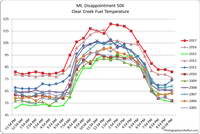
Even it was smoky, at least the weather was cool. Following the torrid conditions at the Mt. Disappointment 50K the previous Saturday, and hot weather during the week, cool was good.

Mt. Pinos is often a good choice for escaping the triple digit heat of a Los Angeles heatwave. The elevation of the Chula Vista trailhead (8350′) is higher than the highest trailhead on Angeles Crest Highway — Dawson Saddle (7909′) and about 1000′ higher than the popular Inspiration Point (7370′) trailhead on the PCT.

Chumash spirit tower on Sawmill Mountain.

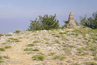
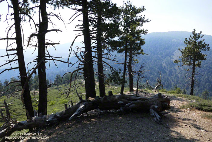
My usual “Pinos to Abel” run starts at the Chula Vista trailhead and follows a dirt service road to the summit of Mt. Pinos (8831′). At the nearby wildlife viewing area it picks up the Vincent Tumamait Trail and heads west, taking a short detour to Sawmill Mountain (8818′) and the Chumash spirit tower, and then continues toward Mt. Abel (Cerro Noroeste). The trail ends at Cerro Noroeste Road, but a short climb up through the pine trees leads to the summit of Mt. Abel (8280+’) and Campo Alto. On the way back I usually run down the North Fork Trail to the spring at Sheep Camp, and sometimes extend the run by descending to Lily Meadows Camp (6250′).

Runners on the Vincent Tumamait Trail below Mt. Pinos.

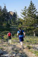
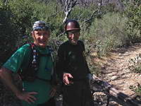
It’s rare to see other runners doing the Pinos to Abel run. Dan and Dameon first passed me descending from Mt. Pinos. Our paths would cross several times over the course of the morning. They were running in the Mt. Pinos area for the first time and having a great time exploring the trails.

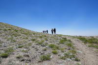
One of those times was on the top of Mt. Abel. They were thinking about hitting Grouse Mountain (8582′) on the way back to Pinos and asked about the route. The use trail to Grouse branches off the Vincent Tumamait Trail near a saddle ENE of the peak and about 0.3 mile west of the North Fork Trail junction. It leads to the northern summit of Grouse’s twin summits in about a quarter-mile.

Horse taking a drink at Sheep Camp.
What’s in the bag?

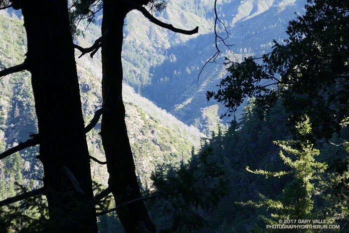
I didn’t do Grouse Mountain today, but did take the North Fork Trail down to Sheep Camp. Today, the plan was to just go a “little way” down the trail below Sheep Camp to see if a particular plant was flowering. Beyond Sheep Camp the North Fork Trail drops like a rock, and it turned into one of those, “I’ll just go a little farther down” kind of things. Before I came to my senses I’d lost nearly 1000′ in elevation while looking for the plant.

After chugging back up to the spring at Sheep Camp, I refilled my Camelbak(TM) and then continued up to the Vincent Tumamait Trail and headed east, retracing my steps to Mt. Pinos, and back to the trailhead.

Some related posts: Thunderstorm, Vincent Tumamait Trail

Record Heat for the 2017 Mt. Disappointment 50K & 25K

Record Heat for the 2017 Mt. Disappointment 50K and 25K

Note: The Mt. Disappointment Endurance Run is now the Angeles National Forest Trail Race.

The heat was oppressive. The air was sweltering and still, reminding me of hot nights in the South, when heat lightning flashed on the horizon, and any movement was an effort. An adductor muscle in my left leg started to cramp and I jumped up from the reclining chair. Heat, and more heat had been the theme of this day. I had returned home from running my eleventh, and hottest, Mt. Disappointment 50K, only to be caught in a widespread power failure caused by a transformer explosion and fire in a Northridge distribution station.

How hot was it for the 2017 Mt. Disappointment races on Mt. Wilson?

In the sun temps recorded by the Clear Creek RAWS for all the Mt. Disappointment races
In the sun temps recorded by the Clear Creek RAWS for all the Mt. Disappointment races. Click for larger image.

– Between 11:00 a.m. and 5:00 p.m. the in the sun temps recorded by the Clear Creek RAWS (on the 50K course) ranged from 115 °F to 121 °F. Out of the sun temps ranged from 94 °F to 98 °F.

– Between 10:30 a.m. and 4:30 p.m. an ANF portable weather station adjacent to the Mt. Wilson Observatory recorded in the sun temps ranging from 106 °F to 114 °F. Out of the sun temps ranged from 92 °F to 96 °F.

– The temperature (inside a ventilated instrument housing) on Mt. Wilson at CBS Radio reached a high of 103 degrees. This appears to be the highest temperature at that location since it came online in 2008 and may have been the hottest temperature on Mt. Wilson in several decades.

– Downtown Los Angeles (USC) reached a record high for the date of 98 degrees, breaking a 131 year old record.

Even more remarkable than the weather were the performances of the top runners. Ruperto Romero was the overall winner of the 50K with an astounding time of 4:38:44. This was only a couple of minutes slower than his winning 2015 time — when temps were 20-30 degrees cooler. In what must have been an exciting finish in the Women’s division, Elizabeth Ochoa cranked out a 6:19:45, just edging out Ana Guijarro by eight seconds. Victor Martinez won the 25K in 2:08:01, with Jay Nadeau taking the top women’s time in 3:05:13. All the Mt. Disappointment results are available on UltraSignup.

The heat continued to build past noon, peaking between 1:30 p.m. and 4:30 p.m. This made for a long day for those of us in the back of the pack. At 1:00 p.m Red Box Road was a blast furnace, facing directly into the sun. I was very glad to have scouted the final seven miles of the course last weekend. The creeks crossing the road really helped to keep from becoming over-heated. Strayns Creek on the Kenyon Devore climb also helped me to cool down.

Many thanks to Gary and Pam Hilliard and all the Mt. Disappointment staff, volunteers, sponsors and runners. The aid station personnel were phenomenal, and all their assistance was much appreciated. The efforts of the Forest Service were also much appreciated. ANF personnel were on the trails and at the aid stations, helping runners.

Some related posts: The Kenyon Devore Trail and Mt. Disappointment 50K,  Mt. Disappointment 50K Returns, Mt. Disappointment 50K 2012 Notes

The Kenyon Devore Trail and Mt. Disappointment 50K

Strayns Canyon from the Kenyon Devore Trail in Angeles National Forest

Note: The Mt. Disappointment Endurance Run is now the Angeles National Forest Trail Race.

The photograph above was taken a little more than a mile from the top of the Kenyon Devore Trail, in the San Gabriel Mountains, near Mt. Wilson. The deep canyon seen through the trees is Strayns Canyon, which the trail follows on its way from the West Fork San Gabriel River to the shoulder of Mt. Wilson.

Bright green Bigcone Douglas fir cones
Bigcone Douglas fir

Today, I’d run down the Kenyon Devore and Gabrieleno Trails to West Fork and then up the Red Box – Rincon Road to point on the map marked Camp Ah-DA-Hi. (A former Woodcraft Rangers Camp.) With hot weather forecast next Saturday for the Mt. Disappointment 50K, I’d been glad to see the small streams that had been dry during the drought were running again.

Trails have stories to tell and when I run or hike a trail I’m always curious about its history. A trail between the West Fork San Gabriel River and Mt. Wilson is shown in the 1:62500 1897 edition of the USGS 1894 Los Angeles Sheet. Like many trails of the era, it followed a ridge, in this case a ridge just east of Strayns Canyon.

Antennae on Mt. Wilson at the top of the Kenyon Devore Trail.

The first USGS map to show a trail along Strayns Creek was the 1:24000 1934 Mt. Wilson Advance Sheet. The trail remained unnamed in USGS maps until the 1966 edition of the 1:24000 Mt. Wilson Quadrangle, when it was labeled the Rattlesnake Trail. The trail was renamed the Kenyon Devore Trail in the 1995 edition of the map in tribute to Forest Service patrolman, hydrographer, and Angeles National Forest volunteer, Kenyon DeVore.

The Kenyon Devore Trail is part of the Mt. Disappointment 50K course. It is one of several trails maintained by runner-volunteers under the guidance of Forest Service volunteer and Mt. Disappointment Race Director, Gary Hilliard. Today, as I was on my way back up to Mt. Wilson, I ran into Gary and two volunteers cutting logs from the trail in preparation for next Saturday’s event.

Gary Valle and Gary Hilliard on the lower Kenyon Devore Trail.
Gary and the Other Gary on the lower Kenyon Devore Trail.

The grueling 5 mile, 2650′ climb from West Fork to Mt. Wilson on the Gabrieleno & Kenyon Devore Trails comes at about mile 26.5 of the 50K and is the highlight of the run.

I have to laugh about what happened on the Kenyon Devore climb one hot year. I’d jammed my Camelbak(TM) with so much ice at the West Fork aid station that when water was added, it melded and froze into one large chunk. I didn’t discover this until about halfway up the climb, when I ran out of water. You can’t drink a chunk of ice and even at 90 degrees, the ice was melting at an agonizingly slow rate. At best I could only get a minuscule sip of water from the pack every few minutes, and it nearly imploded from my efforts.

Some related posts: Mt. Disappointment 50K Returns!, Mt. Disappointment 50K 2012 Notes