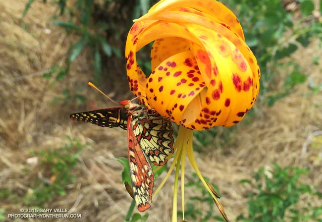
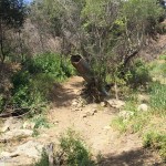
From last Saturday’s Shortcut – Chantry – Mt. Wilson Loop run.
Related post: Checkerspot Along the Garapito Trail

From last Saturday’s Shortcut – Chantry – Mt. Wilson Loop run.
Related post: Checkerspot Along the Garapito Trail
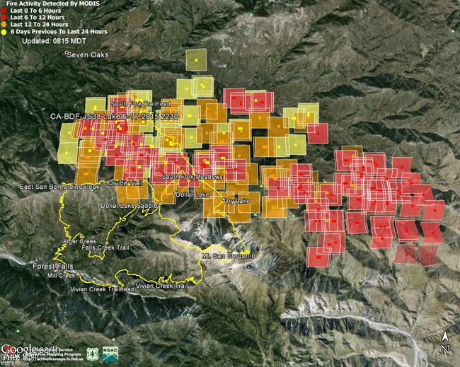
MODIS Fire Detections from June 19. See links below for most recent image
Updated 07/05/15 12:30 p.m. PDT. Added Lake Fire perimeter from GEOMAC timestamped 07/03/15 2335.
The following Google Earth images of MODIS 1km fire detections gives a general idea of the extent of Lake Fire in the San Gorgonio Mountain area of San Bernardino National Forest. The image includes the most recent fire perimeter available from GEOMAC at the time the graphic was created:
Perimeter only timestamped July 3, 2015 at 2335.
Perimeter only timestamped July 1, 2015 at 2324.
Perimeter only timestamped June 28, 2015 at 0200.
Perimeter only timestamped June 25, 2015 at 2356.
June 28, 2015 at 1:45 p.m. PDT – June 26, 2015 at 6:15 a.m. PDT – June 25, 2015 at 6:45 a.m. PDT – June 24, 2015 at 9:00 a.m. PDT – June 23, 2015 at 6:15 a.m. PDT – June 22, 2015 at 7:30 a.m. PDT – June 21, 2015 at 1:15 p.m. PDT – June 19, 2015 at 1:45 p.m. PDT – June 19, 2015 at 7:15 a.m. PDT
For more information see the Lake Fire incident page on InciWeb. As of July 5 8:00 a.m. the fire was reported to be 31,359 acres in size and 90% contained.
Fire detection KML files were generated by the USDA Forest Service MODIS Active Fire Mapping Program. Some additional place names have been added — locations are approximate.
PLEASE NOTE THE FOLLOWING IMPORTANT INFORMATION FROM THE KML FILES:
CONUS MODIS 1km Fire Detections
This KML displays the MODIS fire detections at a spatial resolution of 1km for the past 12 hours, 12-24 hours and the previous 6 day period. Each 1km MODIS fire detection is depicted as a point representing the centroid of the 1km pixel where the fire is detected. The 1km footprint of the MODIS pixel for each detection is also displayed.
KML file generated by the USDA Forest Service MODIS Active Fire Mapping Program. Please see //activefiremaps.fs.fed.us for additional fire mapping products and information.
Disclaimer: Although these data have been used by the USDA Forest Service, the USDA Forest Service shall not be held liable for improper or incorrect use of the data described and/or contained herein. The information contained in these data is dynamic and is continually updated. It is the responsibility of the data user to use the data appropriately and consistent within the limitations of geospatial data in general and these data in particular. Using the data for other than their intended purpose may yield inaccurate or misleading results. The USDA Forest Service gives no warranty, expressed or implied, as to the accuracy, reliability, or completeness of these data. Although these data have been processed successfully on a computer system at the USDA Forest Service, no warranty expressed or implied is made regarding the utility of the data on another system or for general or scientific purposes, nor shall the act of distribution constitute any such warranty. This disclaimer applies both to individual use of the data and aggregate use with other data. The USDA Forest Service reserves the right to correct, update or modify this data and related materials without notification.
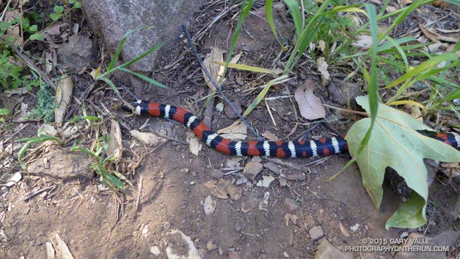
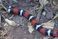
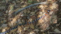
The patterned colors of a mountain kingsnake are hard to miss. The snake’s white-black-red-black-white triads attract attention in just about any habitat. (The amount of red can vary in an individual as well as subgroup.)
Traditionally California mountain kingsnakes (Lampropeltis zonata) have been grouped into several subspecies according to subtle and variable pattern characteristics.
The kingsnake in the title photograph appears to belong to the San Diego mountain kingsnake pattern class (Lampropeltis zonata pulchra). The broken white ring on the head is common in this subgroup in the Santa Monica Mountains.
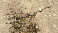
This mountain kingsnake, photographed on Pleasant View Ridge in the San Gabriel Mountains, likely belongs to the San Bernardino mountain kingsnake pattern class, Lampropeltis zonata parvirubra.
Study of California mountain kingsnakes’ mitochondrial DNA (E. A. Myers, et. al., 2013) conservatively supports separate northern and southern species and potentially two lineages within the southern group.
Mountain kingsnakes aren’t the only kingsnake found in the Los Angeles area. This California kingsnake (Lampropeltis getula californiae) was photographed at Ahmanson Ranch a couple of weeks ago. When I approached the snake, it immediately became defensive and started rapidly vibrating its tail. This behavior is often described as mimicking a rattlesnake, but could also predate the development of rattles in rattlesnakes.
For more info on the reptiles and amphibians of California see the californiaherps.com web site.
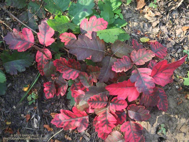
From a run in the Santa Monica Mountains this morning.
Some related posts: Find the Poison Oak, Large Poison Oak Leaves, Sweet Smell of Poison Oak
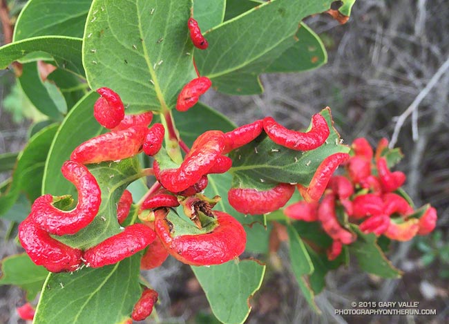
Was running down the Chamberlain segment of the Backbone Trail Saturday, when a flash of bright red on a manzanita bush caught my eye.
Very bizarre, as nature often is. At first glance I thought the bulbous red objects on the manzanita were some kind of larvae, but on closer inspection could see it was a swelling of the leaf. My first thought was some kind of viral infection.
What they turned out to be are aphid induced leaf galls. Galls generally provide a protective habitat and enhanced food source for the inducing species and their tenants.
Related post: Scrub Oak Apple Gall
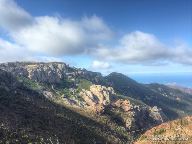
While running in the Marin Headlands last weekend it occurred to me that it had been at least a couple of months since I’d done a a run in Pt. Mugu State Park. In addition to following the recovery of the area since the May 2013 Springs Fire, I’ve been surveying the effects of the December 2014 flash floods in Sycamore Canyon and its tributaries and hadn’t yet looked to see what happened in Serrano Canyon.
When doing a run in Pt. Mugu State Park I almost always start at the Wendy Drive trailhead. I’ve run from that trailhead to Serrano Valley and Canyon a couple of ways. Both routes connect by way of Satwiwa and Danielson Road to the Old Boney Trail. One follows the Old Boney Trail all the way to the Serrano Valley/Canyon Trail. The other climbs up and over Boney Mountain, eventually connecting to the Backbone Trail, and then descends the Chamberlain Trail and rejoins the Old Boney Trail about a mile east of the Serrano Valley/Canyon Trail.
Today’s run was a variation of option B. After climbing Boney Mountain to Tri Peaks, I ran over to Sandstone Peak using the Tri Peaks and Backbone Trails. Sycamore Canyon Fire Road, Two Foxes Trail and Upper Sycamore Trail were used to get back to Satwiwa and the Wendy Drive trailhead from Serrano Canyon.
Some related posts: Pt. Mugu State Park Debris Flows and Flash Floods, Just Me and the Meadowlarks, After the Springs Fire: A Run Through Pt. Mugu State Park