Category Archives: nature|weather

Running Down Diablo

Running the North Peak Trail on Mt. Diablo

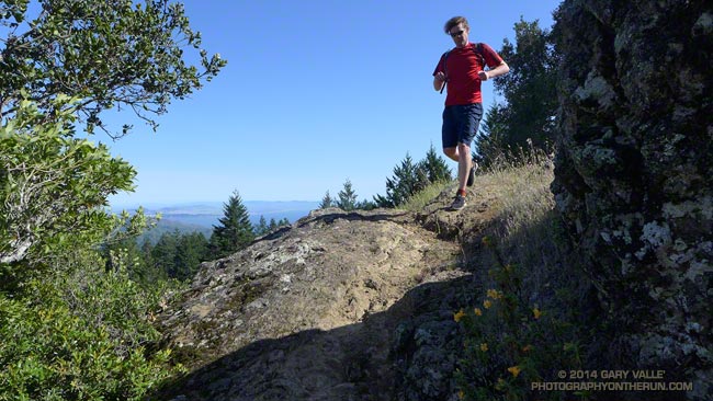
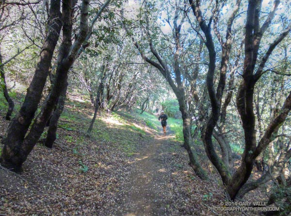
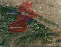
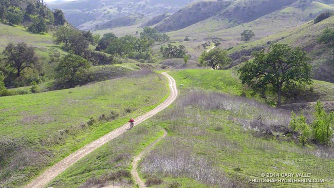
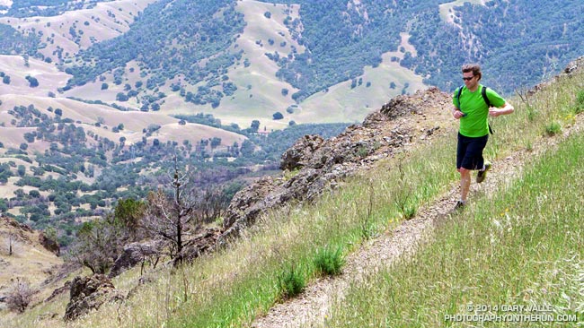
More often than not when you run down a mountain, you’ve also had to climb up it. Not so today. Today our Mt. Diablo run started on the summit of Mt. Diablo (3849′), worked over to North Peak (3557′), and then descended the Bald Ridge, Eagle Peak and Mitchell Rock Trails to the trailhead at the Mitchell Canyon Interpretive Center and Ranger Station.

I was more than happy to save the ascent of Mt. Diablo for another day. With the AC100 just a couple months away my mileage has been on the increase. Yesterday, after driving up to San Francisco, Brett had taken me on a run on Mt. Tamalpais. Earlier today I’d done a run to Fort Point and this afternoon would be doing another run when we returned to the city.

Except for an astoundingly steep and slippery section of service road between Prospector’s Gap and North Peak, today’s run was nearly all single track trail. Not the “cruise downhill, don’t have to think about it” kind of single track, but technically interesting single track that tries hard to find a way to trip you up and knock you down.

Mount Diablo fairy lantern

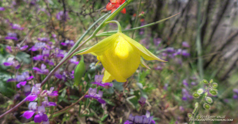
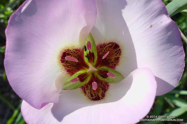
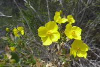
One of the reasons for doing Diablo was to see if we could find the rare and endangered Mount Diablo fairy lantern (Calochortus pulchellus). There were a surprising number (50-100) of the yellow flowers along the North Peak and Bald Ridge Trails. It might be assumed that this was due to the area being burned in the September 2013 Morgan Fire, however there appeared to be as many instances of the plant outside the burn area as inside. I think there is another explanation.

The unusual pattern of rainfall that we experienced this rain season in Southern California was replicated across much of the state, including the Bay Area. As of February 1 San Francisco Airport (KSFO) had recorded only 1.5 inches of rain since July 1 and storms in February and early March accounted for a large part of this season’s rainfall.

This pattern of rainfall, sun and temperature appears to have favored wild lilies, particularly mariposa lilies of the genus Calochortus, such as the Mt. Diablo fairy lantern. The butterfly mariposa (Calochortus venustus) was very widespread on Mt. Diablo, numbering in the thousands. It appears to fill a similar ecological niche as the Catalina mariposa (Calochortus catalinae) in the Santa Monica Mountains. The Catalina mariposa was also very abundant this year, along with some other members of the Lily family.

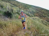
Here are a few photos from the Diablo run.

Coastal Trail Runs and Pacific Coast Trail Runs offer trail running events that start and finish at the Mitchell Canyon Trailhead on Mt. Diablo. Brazen Racing also organizes the Diablo Trails Challenge.

For more information about Mt. Diablo see the Mt. Diablo State Park, Save Mount Diablo and Mount Diablo Interpretive Association web sites. This State Park brochure includes a trail map.

Related post: Diablo Trails Challenge 50K 2018

Tamalpais Trail Run

Running ahead of me at a brisk pace, Brett suddenly stopped and turned, gesturing for me to slow and be quiet. On the shaded trail ahead I could see something large and brown hunched over on the trail. It took a moment to realize that it was a big male turkey in full regalia.

We were on Mt. Tamalpais, and about a half-mile into an afternoon run from the Bootjack parking area in Mt. Tamalpais State Park. This scenic loop was the first of several runs over a too-short Bay area weekend visit. One of the innumerable loops and variations in and near the Park, our route included segments of the Old Mine, Rock Spring and Matt Davis Trails.

According to this November 2012 article in the Marin Independent Journal the turkeys were introduced into Marin County in 1988 by Fish & Game to provide hunting opportunities on private land. They have since become a nuisance and usurp resources from native species. During the birds’ mating season they have reportedly frightened hikers and bikers. (I might have scoffed at that statement before seeing the size of this tom.)

It was a warm in the sun, cool in the shade afternoon with the temperature in the mid-70s. Earlier in the week an offshore flow had pushed temperatures in the Bay area well into the 90s. The heatwave produced numerous record highs, with the temperature at San Francisco Airport reaching over 90 degrees on Tuesday and Wednesday. The remote automated weather station (RAWS) on Middle Peak can be used to get an idea of the weather on Mt. Tam.

Today the winds were onshore, but the visibility was still very good. The twin summits of Mt. Diablo could be clearly seen across the bay, about 40 miles away. Mt. Diablo would be the site of one of tomorrow’s runs. Rumor had it the rare Mt. Diablo fairy lantern was blooming, and Brett had planned a run on Diablo that included North Peak, Bald Ridge and Eagle Peak.

Here are a few photos from today’s run on Mt. Tam. More info can be found on the Mt. Tamalpais State Park and the Friends of Mt. Tam web sites. This State Park brochure includes a trail map.

Trippet Ranch Wildflower Run

Symmetry of mariposa lily

For most of the Winter it looked like there would be very few wildflowers this Spring in the Santa Monica Mountains. The drought had taken its toll, and many chaparral plants were in survival mode. Most were desiccated, some were diseased and a few were dying. Winter-bloomers such as wishbone bush, prickly phlox, shooting star, big berry manzanita and big pod Ceanothus were practically nonexistent.

Then it rained. From February 26 to March 2 many areas of Southern California recorded more than four inches of rain. Los Angeles had the most rain over five days since 2010. Although the rain didn’t end the drought, it did end one of the driest periods in 100 years, and brought crucial relief to the plants and animals.

The response to the rain was virtually immediate and has continued throughout the Spring. The rain resuscitated the vegetation and wildlife and revived habitats. Now, when you run, hike or ride a trail in the Santa Monica Mountains, if you don’t look too closely, the growth and flowering of plants in the chaparral appears to be almost normal.

Rainfall in the area has been only about 40% of normal, but in a few cases plants have responded as if the rain season had been much wetter. Plants fill more than geographical niches in an ecosystem. They fill sub-seasonal niches of rainfall, temperature, sunlight and other parameters. If rainfall occurs at an optimum time or in an optimum pattern for a plant, its benefits can be amplified. The large number of Catalina mariposa lily and wild hyacinth blooming this Spring demonstrate this effect. The growth of non-native black mustard is also more robust and widespread than might have been expected.

Here’s a slideshow of some of the wildflowers currently blooming in the Topanga State Park area of the Santa Monica Mountains. All of the photographs are from this morning’s 12-something mile loop to Trippet Ranch from the “end of Reseda” at Marvin Braude Mulholland Gateway Park.

Some related posts: Garapito Trail Runs, The Heavenly Ranch in the Hills

Leona Divide 50 Mile 2014

Running through oaks on the PCT during the Leona Divide 50 mile ultrarun.

Last June when she heard the news that the Powerhouse Fire was burning in the Leona Divide area of Angeles National Forest ultra RD Keira Henninger must have shaken her head. Just a couple of weeks before the Springs Fire had burned a large part of her Ray Miller 50M/50K course in Pt. Mugu State Park — now the Leona Divide 50M/50K course was on fire.

Some organizers might have just canceled these events outright, but applying the expertise and persistence that makes her a successful ultrarunner and race director Keira put together alternatives that were every bit as enjoyable, challenging and well-organized as the original events. The Ray Miller 50/50 was transformed into the highly regarded Sean O’Brien 50/50 and the Leona Divide 50/50 course was rerouted.


Then just two weeks before the event the Leona Divide courses had to be rerouted a second time because of an unexpected change in the Powerhouse Fire closure area. Not only were the 50M and 50K routes changed, the starting point for the race was changed from Lake Hughes to Green Valley. Here’s an overview of the Leona Divide area that shows this year’s course (yellow), last year’s course (purple), and the perimeter of the Powerhouse Fire (red). Note that the Powerhouse Fire closure area (as of April 25, 2014) is much larger than the area burned by the fire.

If you didn’t know its history, the 2014 Leona Divide 50/50 was so well organized you might have thought it always started in Green Valley. This year all but a few miles of the 50M and 50K courses were run on the Pacific Crest Trail. Here’s an overview of the 2014 course and an interactive Cesium browser View that can be zoomed, panned, tilted and rotated.


An elevation profile for the 50 mile course was created in SportTracks. Elevations were corrected using NED 1/3 arc second DEMs. Using a conservative smoothing setting (55) the elevation gain/loss for the 2014 course was estimated be around 8500′ and for the 2013 course around 7500′. According to the GPS tracks the 2014 course was about 0.5 mile longer than the 2013 course.

The weather for the race could not have been more different than the torrid conditions experienced last year. The NWS issued a winter weather advisory for the Los Angeles County mountains Friday evening that extended into Saturday. Just before the start of the race my car’s thermometer read 37 degrees. It had rained overnight and a few miles into the race, small patches of melting snow were mixed in with the purple chia along the trail. Temps were cool all day, ranging from from the low 40s up into the 50s. Winds were blustery, but were generally less than the 25-35 mph that had been expected.

All things considered, the weather was great for running. If you had any doubt the role heat acclimatization can play in finishing an ultra, you need only compare this year’s six DNFs in the 50 mile to last year’s 42!


My favorite part of the course was the “last minute” addition from Bouquet Canyon to Aqua Dulce. I previewed this segment last week, and in today’s cool, blue sky – puffy cloud conditions it was outstanding. Because I HAD to make the cut-offs, I didn’t take many photos, but here are a few photos taken along the way.

Many thanks to Keira Henninger, the numerous volunteers, the community of Green Valley, the Pacific Crest Trail Association and the Mojave Ranger District for helping to make this event happen. Congratulations to Jay Bonthius, the overall winner in his first 50 mile race, and Kami Semick who took first among the women and placed 10th overall. In the 50K Eric Lynch just edged Chris Glibert for the win in the Mens division and Margaret Nelsen was first in the Women’s division. For more info, photos and all the results see the Leona Divide 50/50 web site and Facebook page.

Some related posts: Up and Over Sierra Pelona Ridge, Back on Leona Divide

Back on Leona Divide

Bob Kimmerly bench on the Pacific Crest Trail

It had been “a while” since I’d run this segment of the Pacific Crest Trail. This photo will give you an idea of just how long. That year January was warm and dry and none of the local creeks had enough water to kayak, so Gary Gunder and I were doing a lot of running. Two of the most enjoyable runs we did were the segments of the PCT from Pine Canyon Rd to Lake Hughes Road (FS 7N05) and Lake Hughes Road to Sierra Highway in Aqua Dulce. These PCT segments are closely associated with the Leona Divide — both the race and geographic feature — and include some of the fastest single track trail in Southern California.


Today I was back in the Leona Divide neighborhood and getting reacquainted with the stretch of the PCT between Bouquet Canyon Road and San Francisquito Canyon Road. Bouquet Canyon Road is the turnaround point for the 2014 Leona Divide 50 mile and this 13 mile stretch — done on the way out and the way back — makes up most of the single track trail on the course.** With the Leona Divide 50/50 coming up April 26 a number of runners (Karl, Dave #1, Matt, Dave #2 and others) were also out on the trail.

This section of the PCT is about as non-technical as a single track trail can be. It’s generally in very good shape with surprisingly few rocks, technical obstacles, or steep hills to slow you down. Most of the trail is in chaparral, out in the open, and on sun-facing slopes. The elevation ranges from about 3300′ to 4300′. Trail mileages are close to what the trail signs advertise — about 7 miles between San Francisquito Canyon Road and Spunky Edison Road, and 6 miles between Spunky Edison Road and the 50 mile turnaround at Bouquet Canyon Road.


The weather could not have been better for today’s run. Some shaded sections of trail were lush and green from recent rains and in places yellow bush poppy, blue Phacelia, purple chia, scarlet bugler and other wildflowers bloomed along the trail. The midday temp was in the 60s at the Grass Mountain RAWS (just off the PCT near Leona Divide Road). The temps at this weather station were in the 80s during last year’s Leona Divide 50/50 when “in the sun” temps reached over 100 degrees.

In today’s cool conditions it was a long run kind of day, and the 26 miles were about as enjoyable as a longer trail run can be.

**Note: The 50M and 50K courses have been rerouted. See the Leona Divide 50/50 web site and the related post Up and Over Sierra Pelona Ridge.