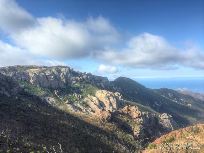
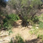
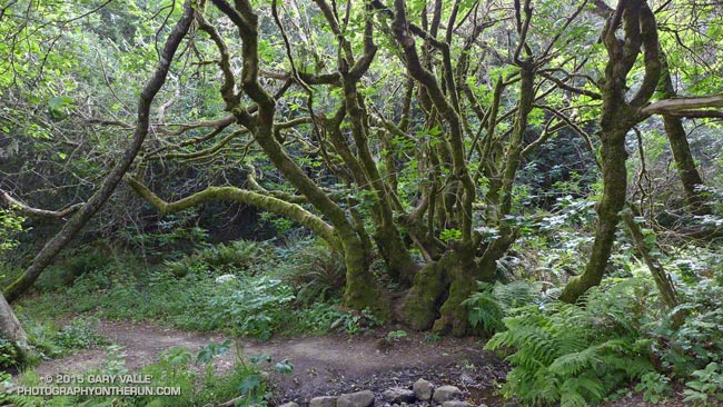
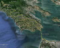
While running in the Marin Headlands last weekend it occurred to me that it had been at least a couple of months since I’d done a a run in Pt. Mugu State Park. In addition to following the recovery of the area since the May 2013 Springs Fire, I’ve been surveying the effects of the December 2014 flash floods in Sycamore Canyon and its tributaries and hadn’t yet looked to see what happened in Serrano Canyon.
When doing a run in Pt. Mugu State Park I almost always start at the Wendy Drive trailhead. I’ve run from that trailhead to Serrano Valley and Canyon a couple of ways. Both routes connect by way of Satwiwa and Danielson Road to the Old Boney Trail. One follows the Old Boney Trail all the way to the Serrano Valley/Canyon Trail. The other climbs up and over Boney Mountain, eventually connecting to the Backbone Trail, and then descends the Chamberlain Trail and rejoins the Old Boney Trail about a mile east of the Serrano Valley/Canyon Trail.
Today’s run was a variation of option B. After climbing Boney Mountain to Tri Peaks, I ran over to Sandstone Peak using the Tri Peaks and Backbone Trails. Sycamore Canyon Fire Road, Two Foxes Trail and Upper Sycamore Trail were used to get back to Satwiwa and the Wendy Drive trailhead from Serrano Canyon.
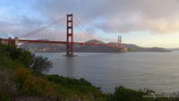
The sign read “Middle Green Gulch Trail” but didn’t indicate if the trail went to Muir Beach. I was on the Coyote Ridge Trail and about 12 miles into a running adventure that had started in the Marina District of San Francisco, crossed the Golden Gate Bridge, and then entered the runner’s Wonderland of the Marin Headlands.
My destination was the Bootjack parking area in Mt. Tamalpais State Park. There are many ways to run to Bootjack from San Francisco, but the game I had decided to play was to pick up the Miwok 100K course at the juncture of the Coastal and SCA Trails and run the course in reverse to Pan Toll. From Pan Toll Bootjack was just a few minutes away.
Golden Gate Bridge
It had gone well so far. The bridge and bay had been spectacular in the broken clouds and early morning light. There had been a bit of a headwind running along Crissy Field, but once across the bridge the wind and temperature had moderated and the weather had become nearly ideal for trail running.
Working up the Coastal Trail
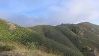
The Coastal, SCA and Alta Trails had been well-signed, so it had been straightforward to get to the the Alta-Bobcat Trail junction. This nefarious juncture is marked with a skull and crossbones on the Miwok 100K map. Here I’d briefly tried to follow the Miwok course in reverse, but bailed and used the more obvious Bobcat Trail to get to the Marincello Trail. Back on route, it had been an enjoyable mile and a half descent to Tennessee Valley.
After chugging up the Miwok Trail from Tennessee Valley, I’d stopped at an unmarked trail and was trying to determine if the single-track was the “Miwok Connector.” I’d only been pondering the question for a minute when some runners happened by and confirmed that it was.
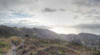
San Francisco Bay, Alcatraz & Angel Island from the SCA Trail
That had been about 20 minutes ago. Now I was trying to get down to Muir Beach and still trying to do the Miwok course in reverse. In my somewhat hastily created cheat-sheet the trail I needed to descend was labeled the “? Trail” which wasn’t a big help. It became one of those, “I’ll just run down to that next corner, where I can get a better view” kind of descents. Corner followed corner, and I soon found myself most of the way down the trail and still up-canyon from Muir Beach.
What was worrisome was that there was a farm in the canyon and it looked like I would have to run through the farm to get to Muir Beach. The trail had to go to a trailhead somewhere. Hopefully somewhere without snarling dogs and shotguns.
I needn’t have worried, I was on the correct route. The farm was Green Gulch Farm Zen Center, a Buddhist practice center. The forest service-style trail sign on the farm’s gate, and some fresh mountain bike tracks, suggested it was OK to pass through, and I was soon on my way to Muir Beach.
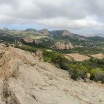
Route Overview
At Muir Beach I wandered around a bit and happened on a Western States 100 runner who gave me directions to the Redwood Creek Trail and also where I could get some water if I needed it. The Redwood Creek Trail was lush, green, and somewhat overgrown, but easy to follow. The stinging nettle mixed in with poison oak ensured that I would pay attention to the plants along the trail.
The Redwood Creek Trail ends at Muir Woods Road near the bottom of the Deer Park Fire Road. The fire road (and Dipsea Trail) border Muir Woods National Monument and cross through the northwest corner of the monument near the top of the climb to Pan Toll. Whether going up or down, or on or off the Dipsea Trail, it is outstanding running through a classic redwood forest.
At Pan Toll I crossed the Panoramic Hwy, picked up the Matt Davis Trail and was soon sitting in the sun at the Bootjack parking area.
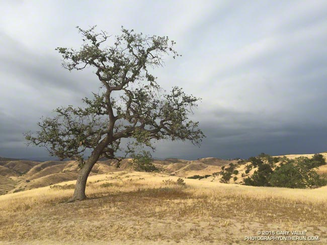
Following four rainfall years in which Downtown Los Angeles (USC) has cumulatively recorded less than half of normal rainfall and accrued a precipitation deficit of more than 30 inches, many of the valley oaks at Ahmanson Ranch (Upper Las Virgenes Open Space Preserve) are drought stressed.
The most obvious signs of drought stress in valley oaks and many other plants are a reduced number of leaves and reduced leaf size. In severely stressed valley oaks the foliage has the appearance of a tree that is recovering from a wildfire.
At Ahmanson the degree of stress varies widely from tree to tree. The “TV tree,” an aesthetically-shaped and often-photographed valley oak on the west side of Lasky Mesa appears to be showing a higher than average level of stress.
Valley oaks and live oaks cohabit the oak savannas at Ahmanson Ranch, but live oaks appear to be more drought tolerant. The lone Blue Oak at Ahmanson seems to be doing OK and has at least as much foliage as it did last year at the same time.
Update January 15, 2021. “The Tree” died in the Spring of 2020, when Ahmanson was closed due to COVID-19. Although scorched in the Woolsey Fire, it never recovered from the 2011-2015 drought, and that appears to have been the primary cause of death.
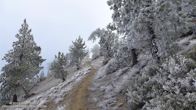
Even with a wind shell and multiple layers the gusts of wind were sharp-edged and penetrating. The weather was spectacular, but it was very windy and very cold.
My run on the PCT had started at Islip Saddle in the San Gabriel Mountains. At 8:00 am the temperature at 6593′ had been about 35 degrees. The north wind funneling through the saddle had roared through the pines, buffeting their stout limbs and telling me to put on every scrap of warm clothing I had in my pack.
The broad canyon of the South Fork seemed to act as a wind tunnel — drawing the wind from the high desert into and over the crest. Even with a gloved hand it took only a couple of minutes before my camera became too cold to hold.
I was on my way to Mt. Baden-Powell and nearly up to Mt. Hawkins. With every stride up the mountain the temperature had dropped. Father Frost had frozen the landscape and me along with it.
Had it really been just a week ago when I had broiled in 90+ degree temps on the south-facing sections of trail on the Leona Divide 50M course?
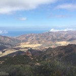
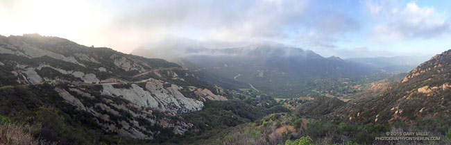
Well, maybe not Shangri-La, but a Lost World kind of morning on the Calabasas Peak fire road segment of the Secret Trail.
Calabasas Peak fire road traverses the rock formations on the left, descending to Stunt Road. At Stunt the route continues up the Stunt High Trail to the Backbone Trail. Here you can do an optional out and back to Saddle Peak, shrouded in clouds in this photo, or turn west on the Backbone Trail and continue mostly downhill to Piuma Road near Malibu Canyon Road. Malibu Canyon is in the distance on the right in the photo.
The panorama is from a run earlier this month. Here’s a larger version.
Although we are still experiencing a record-breaking drought, this rain season did provide a little short term relief to plants and wildlife. Compared to last year rainfall is up 27% at Los Angeles, 39% at Santa Barbara, 57% at LAX and 63% at Camarillo/Oxnard according to NWS data.
The increase in rainy season precipitation dramatically increased plant growth, the abundance of wildflowers, and temporarily increased the availability of key resources to wildlife.
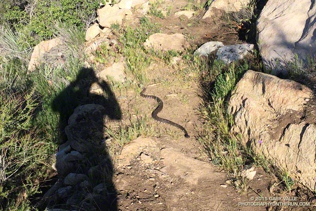
Another thing it seems to have increased is the number of rattlesnakes. Over the past two years I have seen maybe two rattlesnakes total on my runs in the Santa Monica Mountains, San Gabriel Mountains, and in the Big Bear area and on San Gorgonio Mountain. In the Ahmanson Ranch – Cheeseboro area I’ve seen none.
With the increase in rainfall this season that has changed. The title photo was taken on the Leona Divide 50/50 course March 28. That day I encountered two rattlesnakes and talked to a runner that had seen three on the course the previous weekend. From March 26 to April 2 I encountered rattlesnakes on three out of four runs. Two of those were at Ahmanson and it seemed everyone I talked to on the trail was seeing rattlesnakes.
See the rattlesnake? Click for larger view.
There has also been an increase in the number of encounters with non-venomous snakes as well. I’ve seen a number of gopher snakes and a California striped racer. Friends have mentioned seeing a ring-necked snake and California kingsnake.
Since the weather has cooled I haven’t encountered any rattlesnakes, but have seen their tracks. When I run, especially on single-track trails, my snake radar is on and I’m definitely on the lookout for the hard-to-see beasts.