July Deluge a Preview of Southern California’s Upcoming Rain Season?

Pines and clouds in the San Gabriel Mountains

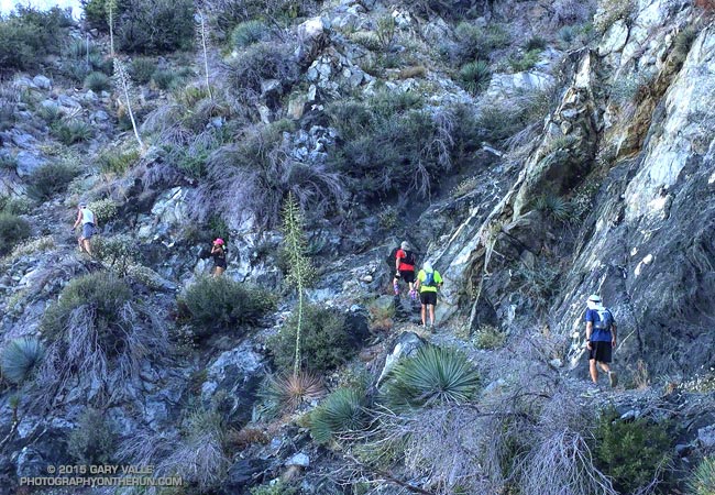
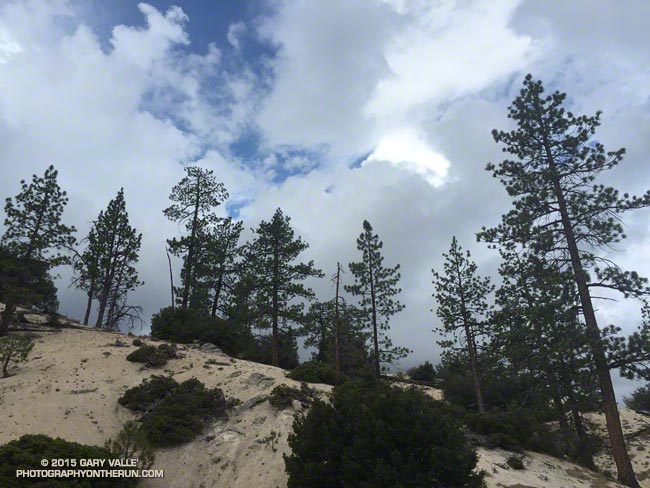
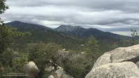
It wasn’t so much a surprise that there was thunder or that it was starting to shower again. It was that I was hearing thunder all around me — to the east toward Mt. Waterman and Twin Peaks, to the south toward Mt. Wilson and the San Gabriel Valley, and to the west toward Big Tujunga Canyon and the San Fernando Valley. This was clearly more than an isolated summer build-up. Pockets of showers, some light and some heavy, could be seen in the distance and I wondered just how wet I was going to get.

Mt. Waterman (left) and Twin Peaks from near Mt. Hillyer in the San Gabriel Mountains
Mt. Waterman (left) and Twin Peaks from near Mt. Hillyer

The answer was “pretty wet!” That was on a run in the San Gabriel Mountains on Saturday, and was the result of the first wave of moisture and instability associated with tropical system Dolores and a strong monsoonal flow from Baja. An even stronger surge of moisture followed Sunday afternoon with rain rates exceeding an inch an hour. From 5:15 p.m. to 5:25 p.m. a CBS Radio weather station on Mt. Wilson recorded a half-inch of rain in just 10 minutes!

NEXRAD regional composite radar image for Southern California at 5:00 p.m. Sunday, July 19, 2015.
Composite radar image for Southern California at 5:00 p.m. Sunday

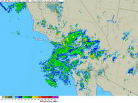
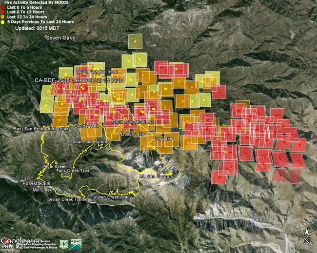
Though the heavy rain created its own problems — including flash floods, debris flows and rock slides — the soaking rains helped quell the Pines Fire near Wrightwood and the North Fire near Cajon Pass. Over the three day period from Saturday to Monday the Big Pines Remote Automated Weather Station (RAWS), near the Pines Fire, recorded 3.12 inches of rain. Several stations in the San Gabriels recorded more than three inches of rain, including Clear Creek and Opids Camp.

Many locations set new records, not only for the date, but for any day in July. Downtown Los Angeles (USC) set rainfall records for the date on Saturday, Sunday and Monday. Downtown Los Angeles recorded 0.36 inch of rain Saturday. This is more rain than any day in any July since recordkeeping began in 1877. That one day of rainfall even broke the monthly record for July in Los Angeles! Prior to this event the wettest July on record was in 1886, when 0.24 inch was recorded.

Strengthening El Nino conditions and the active phase of the Madden-Julian Oscillation contributed to the development of Dolores in the Eastern Pacific, enhancing convection. Anomalously warm SSTs in the tropical and sub-tropical Eastern Pacific also played a role, helping to maintain the strength of Dolores and increasing the amount of water vapor entrained by the system.

This year’s El Nino is very different than last year’s on again, off again event. This year’s El Nino is already established, well-coupled with the atmosphere and growing in strength. It’s firing on all cylinders and at this point it appears the only question is, “How strong will it get?”

Mt. Disappointment 50K Returns!

Runners work up the San Gabriel Peak Trail toward Mt. Disappointment.

Note: The Mt. Disappointment Endurance Run is now the Angeles National Forest Trail Race.

Following a two year hiatus the challenging Mt. Disappointment 50K was run today in near perfect weather conditions.

Temperature at Clear Creek for Mt. Disappointment 50Ks from 2005-2015
Temperature at Clear Creek for Mt. Disappointment 50Ks

How did the temperature today compare to the torrid conditions in 2012? The HIGH temperature today at Clear Creek — 76 °F — was 7 degrees COOLER than the temperature BEFORE SUNRISE in 2012 — 83°F! It was warm in the sun in a couple of places today, but nothing compared to the 115°F in the sun in 2012.

Runners at the starting line on top of Mt. Wilson for the 2015 Mt. Disappointment 50K & 25K
Runners at the Start line on Mt. Wilson

This was the ninth running of the event, which began in 2005, and the first time since 2008 that the 50K was run on the original course. In 2009 a rockslide closed the Mueller Tunnel, resulting in a detour down the Mt. Wilson Road. In 2010, 2011 & 2012 portions of the course were closed as a result of the devastating Station Fire and subsequent flash floods. This required a rerouting the course and adding the infamous climb up Edison Road to Shortcut Saddle. The iconic climb up the Kenyon Devore Trail has been a hallmark of the event every year in which it has been run.

Elevation profile for the 2015 Mt. Disappointment 50K
Elevation profile for the 50K

Here’s an elevation profile and an experimental Cesium browser view of a GPS trace of the course, with mile splits generated by SportTracks. The view can be zoomed in & out, rotated and tilted. Mileages and placemark locations are approximate. It does not require a plug-in and should work on most devices.

Gary Hilliard (with wife Pam) briefs the runners on the details of the 50K and 25K courses.
Gary & Pam Hilliard

Many thanks to Gary & Pam Hilliard, Fausto & Cindy Rowlan, and all of the Mt. Disappointment 50K Staff, volunteers, HAM radio operators, Sierra Madre SAR personnel, runners, and sponsors that have helped make all nine Mt. Disappointment 50Ks such outstanding events! I’m already looking forward to running number 10!

Photos and results can be found on the Mt. Disappointment web site.

Some related posts: Mt. Disappointment Notes: 2012, 2011, 2010, 2009, 2008.

Shortcut – Chantry – Mt. Wilson Loop

Twin Peaks Sunrise from Shortcut Saddle

Yes, there were a few gnats; and for sure, it was little warm and muggy; and without question the Silver Moccasin Trail had a few downed trees and was a bit overgrown. It was still an excellent run!

The idea was to do a loop from Shortcut Saddle and do 20 miles or so of the Angeles Crest 100 Mile course. Craig and I were training for the AC100 and Ann was training for TransRockies and UTMB. Art, who would be crewing and pacing me at AC100, was joining us for part of the run.

Training philosophies for 100 milers vary, but one constant in most approaches is doing a marathon or longer run in the mountains most weekends — usually back-to-back with another run.

As the sun crested Twin Peaks we left Shortcut and began the 5.5 mile descent of Edison Road. The good news was we were not running up this beast. Even so, it is a long way to the bottom. That gave us plenty of time to talk about past experiences and upcoming races, and to ponder the “No entrance permitted” signs at cliff faces, culverts and other impassable places along the road.

I had expected temps to be pleasantly cool on this section, but the day had dawned clear, warm, and a little humid. Lately it seemed every run had been an AC100 heat training run and it looked like today’s run would be no exception. There wasn’t a cloud in the sky and I wondered just how hot the climb to Wilson was going to be.

Eventually the service road bottomed out at the West Fork San Gabriel River. Sadly the river was a trickle that could be easily bridged in one step.

At Newcomb Saddle we said goodbye to Art and continued over to Newcomb Pass and down the Gabrielino Trail to Chantry Flat. Once down into the shade of the tall trees in Big Santa Anita Canyon, the running was idyllic. At the Green Bridge we began the short, but steep, climb up to Chantry. At Chantry we would refill and rehydrate before continuing on the Upper Winter Creek Trail to the Mt. Wilson Trail and its junction with the Mt. Wilson Toll Road. The approximately 6.8 mile climb from the Green Bridge to the Mt. Wilson Toll Road is the longest on the AC100 course, and has the most elevation gain — over 3500′.

We did not complain when monsoonal clouds began to creep in from the east. The varying clouds brought some relief from the heat and humidity, and by the time we reached the Mt. Wilson Toll Road the temperature had dropped from the mid-eighties to the mid-seventies.

The clouds continued to thicken and as we topped out on Mt. Wilson a few rogue raindrops made it to the ground. Once again we refilled and rehydrated. From here we would follow the Mt. Disappointment 50K course backwards to West Fork. The descent down the Kenyon Devore and Gabrielino Trails to West Fork and the climb out to Shortcut would be a good simulation of the descent to Idlehour and climb to Sam Merrill on the AC100 course.

It had been a while since I’d run down Kenyon Devore. It is the iconic climb of the Mt. Disappointment 50K. Running down Kenyon Devore gives you no idea of what it’s like to ascend the trail after running 26 miles. All of us are entered in the Mt. Disappointment race and will be enjoying uphill side of Kenyon Devore in a couple of weeks.

Given the severity of the drought we had wondered if the usually reliable water source at West Fork would be running. The flow from the pipe was surprisingly strong. The water wasn’t necessary to complete the run, but it sure was nice to dunk my head in the cool stream!

Another thing we had wondered about was the condition of the Silver Moccasin Trail between West Fork and Shortcut. The Mt. Disappointment 50K race has not been run on this segment since 2012 and this year is back to it’s original route. Had any trail maintenance been done?

It didn’t look like it. Craig and I had done trailwork here in 2011 and today the trail along the canyon bottom was almost unrecognizable. Recovery from the 2009 Station Fire continues and growth along the stream has been robust to say the least. If you are not into crawling over trees and navigating overgrown trails, finishing at Red Box using the Gabrielino Trail or Red Box Road would be another option.

Once away from the stream and out of the canyon bottom, the Silver Moccasin Trail returned to normal and Ann set an unrelenting pace back up to Shortcut.

According to SportTracks the loop worked out to about 31.5 miles with an elevation gain/loss of about 7600′. Here’s a Google Earth image of an overview of the route.

Related post: The Ups and Downs of the Angeles Crest 100 Mile Run

Lake Fire MODIS Fire Detections

Lake Fire MODIS Fire Detections

MODIS Fire Detections from June 19. See links below for most recent image

Updated 07/05/15 12:30 p.m. PDT. Added Lake Fire  perimeter from GEOMAC timestamped 07/03/15 2335.

The following Google Earth images of MODIS 1km fire detections gives a general idea of the extent of Lake Fire in the San Gorgonio Mountain area of San Bernardino National Forest. The image includes the most recent fire perimeter available from GEOMAC at the time the graphic was created:

Perimeter only timestamped July 3, 2015 at 2335.
Perimeter only timestamped July 1, 2015 at 2324.
Perimeter only timestamped June 28, 2015 at 0200.
Perimeter only timestamped June 25, 2015 at 2356.

June 28, 2015 at 1:45 p.m. PDTJune 26, 2015 at 6:15 a.m. PDTJune 25, 2015 at 6:45 a.m. PDTJune 24, 2015 at 9:00 a.m. PDTJune 23, 2015 at 6:15 a.m. PDTJune 22, 2015 at 7:30 a.m. PDTJune 21, 2015 at 1:15 p.m. PDTJune 19, 2015 at 1:45 p.m. PDTJune 19, 2015 at 7:15 a.m. PDT

For more information see the Lake Fire incident page on InciWeb. As of July 5 8:00 a.m. the fire was reported to be 31,359 acres in size and 90% contained.

Fire detection KML files were generated by the USDA Forest Service MODIS Active Fire Mapping Program. Some additional place names have been added — locations are approximate.

PLEASE NOTE THE FOLLOWING IMPORTANT INFORMATION FROM THE KML FILES:

CONUS MODIS 1km Fire Detections

This KML displays the MODIS fire detections at a spatial resolution of 1km for the past 12 hours, 12-24 hours and the previous 6 day period. Each 1km MODIS fire detection is depicted as a point representing the centroid of the 1km pixel where the fire is detected. The 1km footprint of the MODIS pixel for each detection is also displayed.

KML file generated by the USDA Forest Service MODIS Active Fire Mapping Program. Please see //activefiremaps.fs.fed.us for additional fire mapping products and information.

Disclaimer: Although these data have been used by the USDA Forest Service, the USDA Forest Service shall not be held liable for improper or incorrect use of the data described and/or contained herein. The information contained in these data is dynamic and is continually updated. It is the responsibility of the data user to use the data appropriately and consistent within the limitations of geospatial data in general and these data in particular. Using the data for other than their intended purpose may yield inaccurate or misleading results. The USDA Forest Service gives no warranty, expressed or implied, as to the accuracy, reliability, or completeness of these data. Although these data have been processed successfully on a computer system at the USDA Forest Service, no warranty expressed or implied is made regarding the utility of the data on another system or for general or scientific purposes, nor shall the act of distribution constitute any such warranty. This disclaimer applies both to individual use of the data and aggregate use with other data. The USDA Forest Service reserves the right to correct, update or modify this data and related materials without notification.

Kingsnake Along the Garapito Trail

California mountain kingsnake along the Garapito Trail in the Santa Monica Mountains

The patterned colors of a mountain kingsnake are hard to miss. The snake’s white-black-red-black-white triads attract attention in just about any habitat. (The amount of red can vary in an individual as well as subgroup.)

San Diego mountain kingsnake along the Garapito Trail
San Diego mountain kingsnake

Traditionally California mountain kingsnakes (Lampropeltis zonata) have been grouped into several subspecies according to subtle and variable pattern characteristics.

The kingsnake in the title photograph appears to belong to the San Diego mountain kingsnake pattern class (Lampropeltis zonata pulchra). The broken white ring on the head is common in this subgroup in the Santa Monica Mountains.

San Bernardino mountain kingsnake on Pleasant View Ridge in the San Gabriel Mountains
San Bernardino mountain kingsnake

This mountain kingsnake, photographed on Pleasant View Ridge in the San Gabriel Mountains, likely belongs to the San Bernardino mountain kingsnake pattern class, Lampropeltis zonata parvirubra.

Study of California mountain kingsnakes’ mitochondrial DNA (E. A. Myers, et. al., 2013) conservatively supports separate northern and southern species and potentially two lineages within the southern group.

California kingsnake in Upper Las Virgenes Canyon Open Space Preserve
California kingsnake

Mountain kingsnakes aren’t the only kingsnake found in the Los Angeles area. This California kingsnake (Lampropeltis getula californiae) was photographed at Ahmanson Ranch a couple of weeks ago. When I approached the snake, it immediately became defensive and started rapidly vibrating its tail. This behavior is often described as mimicking a rattlesnake, but could also predate the development of rattles in rattlesnakes.

For more info on the reptiles and amphibians of California see the californiaherps.com web site.

Photography and inspiration from running and other adventures in the Open Space and Wilderness areas of California, and beyond. No ads. All content, including photography, is Copyright © 2006-2024 Gary Valle. All Rights Reserved.