
Update July 21, 2023. Another big snow year. This Google Earth image of San Gorgonio Mountain is overlain with Copernicus/ESA Sentinel 2 imagery taken on July 19, 2023. The GPS track (yellow) is the upper portion of the Dollar Lake – Dry Lake Loop, a keyhole loop that starts at the South Fork Trailhead.
The weather was Southern California perfect. Shorts and short-sleeves were the dress of the day. Winds were light, no thunderstorms were in the forecast and no large wildfires polluted the air. Although temps in the valleys were nearing 100 degrees, the weather on the summit of 11,499′ San Gorgonio Mountain was altitude-conditioned bliss.
I’d spent about 15 minutes enjoying the summit, then run back down the Summit Trail. Turning left onto the Sky High Trail, I continued a keyhole loop that had ascended the South Fork Trail, Dollar Lake, and San Bernardino Divide Trails. Altogether, the route was about 21 miles long and the approximate elevation gain/loss was 4700′.
From the start of the run, the effects of the wet 2018-19 Winter and big snowpack were everywhere. Wildflowers bloomed in profusion, seeps and small streams greened the landscape, and grasses and ferns grew thick beneath the trees. The roar of the streams at South Fork Meadows left little doubt as to what kind of Winter it had been.
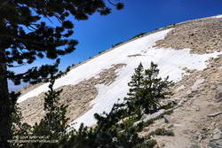
On the way up the Dollar Lake Trail, I’d seen elongated patches of snow in the chutes along the crest. While there was no snow directly on the trail between Dollar Lake Saddle and the summit, there was more snow than usual on the north side of the peaks.
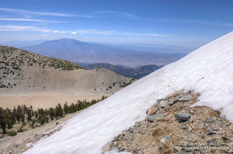
But there was snow on the Sky High Trail. Topping out at over 11,300′, the Sky High Trail is one of the most spectacular trails in Southern California. I marvel at its airy location every time I run it. Near the top of the trail, I’d crossed a small patch of snow and thought, “Well, at least there was a little snow on the trail.”
A little disappointed, I’d put my poles away and continued running down the trail. At around 11,100′ I rounded a corner and surprise, surprise — there was a much larger patch of snow on a southeast-facing section of trail. It was about 100 yards across and steep enough that a fall would be a bad idea. Fortunately, the snow conditions were perfect. A few hikers had recently traversed the snowfield, and I followed in their footsteps.
However, that wasn’t the last of the snow. At an elevation of about 10,200′, not far past the C-47 crash site, the trail crosses a long chute that extends nearly to the top of Gorgonio. The snow in that chute had melted just enough that a thin strip of trail was exposed.
Thinking that had to be the last of the snow, I continued the traverse to Mineshaft Saddle (9936′) and began the descent of the Dry Lake Trail. Once past a rocky section of the trail, I picked up the pace, energized by the increased oxygen at lower elevation. Enjoying the downhill, I descended into an area of converging chutes and gullies, when the path through the lodgepole forest abruptly ended.
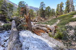
The trail was obliterated. Large trees were ripped from the ground, broken, tossed, and piled up as if they were matchsticks. Underneath the debris were mounds of dense, icy snow — the remnants of an avalanche. This report on SoCalSnow.org includes photos of an avalanche in February 2019 on the north face of San Gorgonio and mentions previous avalanches.
That snow, at an elevation of about 9400′, had finally been the last on the trail. Because the compressed snow is effectively a big block of ice, it could be around for a while.
In the area of the avalanche, the Dry lake Trail enters a large area of rocky rubble that extends into the Big Draw. According to the Dibblee Geologic Map for San Gorgonio Mountain, this rubble is glacial till, produced by the largest of several pocket glaciers that existed on San Gorgonio Mountain, Shields Peak, and San Bernardino Peak.
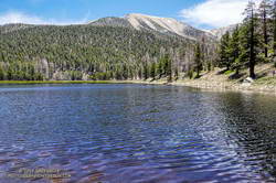
Continuing down the trail to Dry Lake I saw where some of this season’s meltwater had gone — for the first time since 2011, Dry Lake was full in late July.
Last Saturday’s run was so enjoyable that yesterday I went back to Gorgonio and did it again. As might be expected during a Southern California Summer heatwave, the snow on the Sky High Trail, and elsewhere, is melting fast and won’t be around for long.
Here are a few photos taken along the way. The album includes photos from both the July 27 and August 3 runs. A couple of photos from a run on September 7 were also added.
Some related posts: San Gorgonio Mountain Snow Follow Up, Still a Little Snow in Southern California; San Gorgonio Mountain: Falls Creek Loop, August 2017; After the Lake Fire: The Dollar Lake – Dry Lake Loop on San Gorgonio Mountain