An Out-of-the-Way Trail, Two Peaks, a Wheelbarrow, and Washington’s Monument

Forsee Creek canyon from the John's Meadow Trail in the San Gorgonio Wilderness.

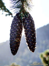
Wow, what a fantastic trail, canyon, and morning!

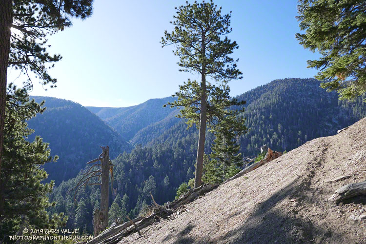
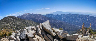
The view above is from the John’s Meadow Trail, a circuitous trail that winds its way through a less-traveled part of the San Gorgonio Wilderness.

Sugar pine cones
Sugar pine cones along the John’s Meadow Trail.

The prominent canyon in the photo is home to Forsee Creek. During the last ice age, it held one of San Gorgonio’s small glaciers. I’d just crossed the Forsee Creek a few minutes before, and in a few hours would run past its source high on the crest — Trail Fork Springs.

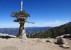
The peak at the head of the canyon is East San Bernardino Peak (10,691′). Its summit marks the crest of the divide and the location of the San Bernardino Peak Divide Trail. That’s where I was headed, but the path would be anything but direct.

From the Forsee Creek crossing at 7270′, the John’s Meadow Trail climbs about 1000′ in 2.3 miles to join the Divide Trail at “wheelbarrow junction,” about 5 miles west of East San Bernardino Peak. From that point I worked up the popular and scenic Divide Trail, visiting Limber Pine Bench (9330′), Washington Monument (10,290′), and San Bernardino Peak (10,649′) along the way to East San Bernardino Peak.

A weather-beaten lodgepole pine at Limber Pine Bench on the San Bernardino Peak Divide Trail.
Weather-beaten lodgepole pine.

Using this roundabout — but very scenic — route, it took me about the same time to reach San Bernardino Peak from the Forsee Creek Trailhead as it does to do San Gorgonio Mountain from the South Fork Trailhead. From San Bernardino Peak it’s a little less than a mile to East San Bernardino Peak and from there only about 0.75 mile to the lateral to Trail Fork Springs.

From the westernmost Trail Fork Springs junction with the Divide Trail the theme was downhill, downhill, and more downhill — about 3800′ of downhill over 6.7 miles.

The running on the Forsee Creek Trail was generally very good. I was glad I did the loop counterclockwise. The John’s Meadow Trail and its extension are enjoyably primitive — they appear to be “use” trails that have evolved over time. On the other hand, the Forsee Creek Trail is a constructed trail. It was designed as a pack trail, so is generally well-behaved. Great for going down, but a long haul up with a heavy pack!

San Gorgonio Mountain and San Jacinto Peak from East San Bernardino Peak.
San Gorgonio and San Jacinto from East San Bernardino Peak.

Here are a few photos taken along the way, and here is an interactive Cesium ion view of the GPS trace of my route. The 3D view can be zoomed, tilted and panned.

Note: Water is generally more reliable and accessible on the John’s Meadow Trail than on the Forsee Creek Trail. Trail Fork Springs and Jackstraw Springs are seasonal water sources that may not have water. Check with the Mill Creek Ranger Station for the current conditions and more info.

San Gorgonio Mountain Snow Follow Up

Hiker working up the Sky High Trail on San Gorgonio Mountain in Southern California
Hiker on the Sky High Trail

One of the things I’d been curious to see when running the Kodiak 50K in mid-August was how the summit snow band on San Gorgonio Mountain was holding up. The answer turned out to be fairly well. Now, a few weeks later, I was back on Gorgonio, chugging up the South Fork Trail, and on my way to see if any snow remained on the mountain.

Runoff from thunderstorms during the week had left the trail rocky and rutted. From the views of the mountain I’d glimpsed from the trail, I wondered if the rain had also washed away any remaining patches of snow.

Snow band near the summit of San Gorgonio Mountain. September 7, 2019.
Snow band near the summit of San Gorgonio Mountain on September 7, 2019.

In addition to that question, I also want to follow up on my earlier “field checks” this Summer and see how much water there was in Dry Lake, and if any snow remained in the avalanche debris above Dry Lake.

I was about a quarter-mile from the Dry Lake – Dollar Lake junction at South Fork Meadows, making decent time, when I heard footsteps behind me. I stepped to the side so he could pass, and we talked as we worked up the trail. Kevin said he’d been climbing in the Sierra just about every weekend and was really well-acclimated.

I asked him what route he was doing to the summit, and he said the Dry Lake route. I told him I was doing the Dollar Lake Trail route up and the Dry Lake route down. He was clearly moving faster than me and said he was shooting for a time of 4:20 to the summit. I mentioned the Dollar Lake route was shorter and faster, and depending on the number of stops for photos, I expected to get to the summit in around 3:45. We talked about some Sierra peaks and being in the mountains, and after a couple of minutes, he began to pull away.

Trail runner at Dry Lake on San Gorgonio Mountain
Dry Lake on September 7, 2019.

The early morning temperature had been a little more chilly than my earlier trips up Gorgonio this Summer. I debated pulling on my sleeves, but by the time I was in the sun on the Dollar Lake Trail, the temperature had warmed to a comfortable 50-something — perfect for ascending the peak.

The summit of San Gorgonio was a very busy place when I arrived. I’d estimate 40-50 people were on or around the summit. Most were part of one huge group that had come up Vivian Creek.

The good news was part of the summit snow band had not melted. Wow! It was September 7, and there was still snow in Southern California!

Copernicus Sentinel satellite imagery of snow on San Gorgonio Mountain on August 27, 2019.

Kevin caught up to me on the descent of the Sky High Trail. We’d both made the summit within a couple of minutes of our projections, leaving little doubt that the Dollar Lake Trail is the fastest route to the summit from the South Fork Trailhead.

I didn’t see any snow remaining in the avalanche debris above Dry Lake. The lake itself was in great shape, and the streams at South Fork Meadows were flowing nearly as vigorously as they had been a month ago.

I’ve added a couple of photos from this trip to the San Gorgonio Mountain Snow, Avalanches and Glaciers slideshow.

Update November 26, 2019. A small amount of snow from the 2018-19 season has survived on San Gorgonio Mountain until the first persistent snow of the 2019-20 season! Copernicus Sentinel satellite imagery from November 17, 2019 showed small patches of snow in two areas. The first winter storm of the season brought snow to the mountains a couple days later, and more snow is expected over the Thanksgiving holidays.

Update October 21, 2019. Copernicus Sentinel satellite imagery from October 21, 2019 still showed a few very small patches of snow on San Gorgonio Mountain. One of the patches is at a surprisingly low elevation of about 10,360′.

Update September 18, 2019. Copernicus Sentinel satellite imagery from September 18, 2019 still showed a few small patches of snow on San Gorgonio Mountain.

Related post: San Gorgonio Mountain Snow, Avalanches and Glaciers