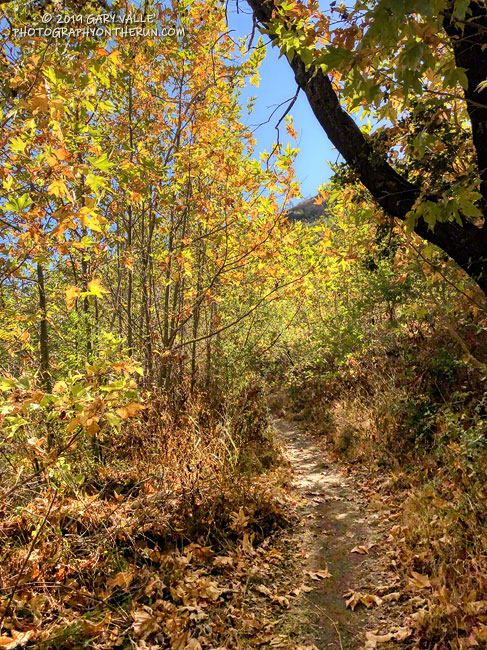
The Upper Sycamore Trail connects Sycamore Canyon Road and Danielson Road in Pt. Mugu State Park.
The scenic single-track trail crosses upper Sycamore Creek several times as it works through the canyon — a canyon cut by the creek along the trace of the Sycamore Fault. About 1.4 miles long, the trail gains approximately 400′ in elevation on it’s way up to Danielson Road.
This morning I’d done part of the Ray Miller 50K course, along with Mugu Peak, and then returned up-canyon on the Two Foxes Trail and Sycamore Canyon Road. With the low sun, the sycamores changing color, and it being just a few days before Thanksgiving, the run through the canyon on the Upper Sycamore Trail was especially enjoyable.
This time of year, I’m often “racing the sun” on my afternoon runs. Especially on longer runs, when the additional miles quickly consume any remaining daylight. There are benefits. Colorful sunsets are just one of them.
Tuesday’s run was one of those longer runs — from the Victory Trailhead of Upper Las Virgenes Canyon Open Space Preserve (Ahmanson Ranch) to Cheeseboro Canyon and back. One of the reasons for doing this particular run was to follow up on the reemergence of water in upper Las Virgenes Creek. As Fall has progressed, there has been a notable increase in the size and number of pools, and the amount of water in the creek. I’ve observed this in the Fall before, except during periods of drought.
This comparison shows a crossing of upper Las Virgenes Creek about one-third mile north of the junction of Las Virgenes Canyon and East Las Virgenes Canyon. It shows the intriguing reemergence of water in this reach of the creek, despite a dry Summer, and — as of Tuesday — meager Autumn rainfall. The increase in water in the reach seems to have resulted from seasonal reductions in daylight, temperature, evaporation, plant transpiration, and other factors.
Update October 22, 2019. A run over to upper Las Virgenes Creek supported the 0.46 inch of rain reported by the Cheeseboro RAWS on October 20. The ground appeared to have absorbed more rain in the Las Virgenes Canyon area, compared to the area near the Victory Trailhead. It also looked like the amount of water in the creek bed had increased.
Update October 21, 2019. The Cheeseboro RAWS, on the ridge just west of upper Las Virgenes Creek, recorded 0.46 inch of rain on October 20, the day after this run. Today, I’ll be running out that way again to see how the rain affected the creek.
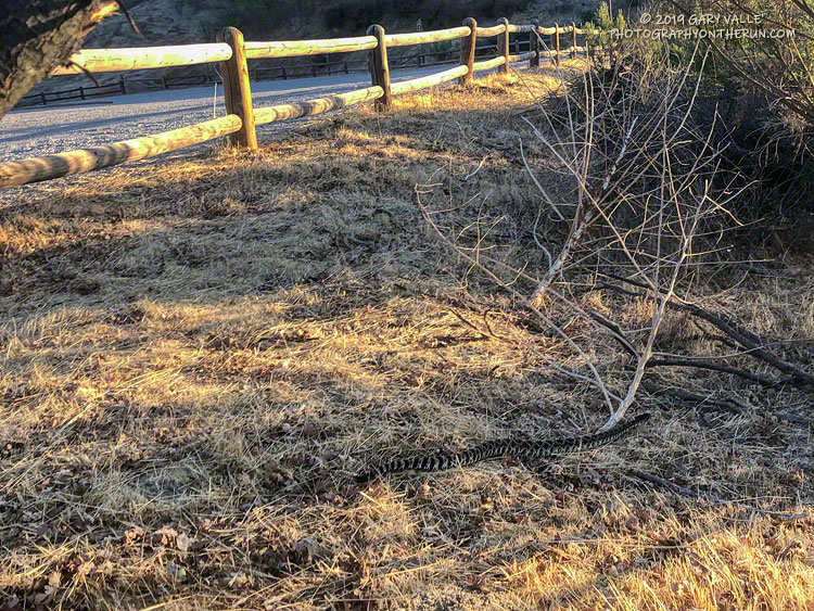
I pressed the START/STOP button on my Garmin watch and started to walk over to the horse/hiker entrance at the Victory Trailhead of Upper Las Virgenes Canyon Open Space Preserve (Ahmanson Ranch). This “end of an Ahmanson run” routine is something that I repeat around 150 times a year. It’s so routine, it’s rote. I’m not thinking about rocks or ruts, or how far I have to go. It’s a time I can relax and reflect on the run, the weather, or whatever.
Continuing toward the trailhead entry, I pulled the water bottle from my pack. Lifting my head to take a drink, and still on auto, I began to step over the first of two large wooden beams forming the entrance.
Some primitive, protective mechanism recognized the threat before I did, and I stopped mid-stride. Then it registered — a sizable Southern Pacific rattlesnake was undulating through the boxed-in area between the two beams of the entryway.
Moving quickly through the entry and into the grass, the snake barely reacted to me. With single-minded resolution, it continued on a beeline toward the brushy area near the trailhead. A single shake of its rattle was all the bother I was worth. Here’s a short video of the Southern Pacific rattlesnake at the Ahmanson Ranch trailhead.
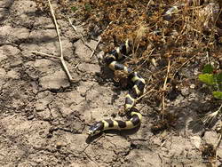
California kingsnake
Surprisingly, this was the first rattlesnake I’ve seen this year at Upper Las Virgenes Canyon Open Space Preserve . I’ve seen numerous gopher snakes, a couple of California kingsnakes, a California whipsnake, and the tracks of many rattlesnakes, but no actual rattlesnakes. Others have described various rattlesnake encounters at Ahmanson — one friend saw three on one ride!
Note: Most of these snakes were old enough to have survived the November 8, 2018, Woolsey Fire.
It was about 15 minutes before sunrise when I started my run from the trailhead at the “Top of Reseda.” After running up to Mulholland and partway down Fire Road #30, I could see a batch of tropical-looking clouds to the southeast. These were associated with a cutoff upper-level low that had formed off the coast of Southern California on Halloween.
The behavior of cutoff upper-level lows is difficult to forecast. They are usually separated from the general west to east flow and typically wobble around like a spinning top. A cutoff low can remain off the coast for several days or more. Just where they wobble can dramatically impact the weather. So far this morning, the only effect of this weak low had been to embellish the sunrise with a few clouds, but such lows can be capricious, and this one was no exception.
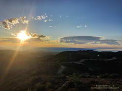
My first stop was going to be Temescal Peak, and I picked up the pace a bit, curious to see how the clouds and sunrise might look from that viewpoint. Temescal Peak is just off the Backbone Trail, near its junction with Temescal Ridge Fire Road. On a clear day this tiny peak affords an exceptional 360-degree view that can include Mt. Baldy, San Gorgonio Mountain, San Jacinto Peak, Mt. Pinos, Hines Peak, and other area landmarks.
Sunrise over West L.A. from Temescal Peak in the Santa Monica Mountains.
Turning left at the Hub, it didn’t take long to get to Temescal Peak. Westward from the peak, a veil of smoke could be seen in the vicinity of the Maria Fire. Nearby, some of the canyons in the area of the Getty Fire were filled with a smoky haze. In the distance, a few mercurial clouds were scattered across the eastern sky.
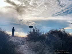
At the time, I couldn’t tell if the clouds were approaching or receding, developing or dissipating. Returning to the Hub, I turned left on Eagle Springs Fire Road and began the descent toward Trippet Ranch. On the way, it became clear the clouds were headed my way. By the time I’d run to Trippet Ranch and up to the top of the Musch Trail, the band of clouds covered much of the eastern sky. Virga streamed from the bases of some of the clouds, and I wondered if a few rogue drops might be reaching the ground.
Developing clouds from near the top of the Musch Trail.
Over the remainder of the run — past Eagle Rock and through Garapito Canyon — the clouds continued to move overhead. A few drops of rain found me near the end of the run, but the most pleasant surprise occurred on the drive home, when showers dampened the streets of the western San Fernando Valley.
There had been no rain in the Los Angeles area this October, and the showers reminded me of the erratic nature of Autumn precipitation in Los Angeles. Even though “normal” rainfall in October at Downtown Los Angeles (USC) is 0.66 inch, no one familiar with L.A. weather is surprised when October is dry. Over 143 years, Downtown Los Angeles has recorded no October rainfall 26 times, 0.10 inch or less 54 times, and 0.25 inch or less 74 times.
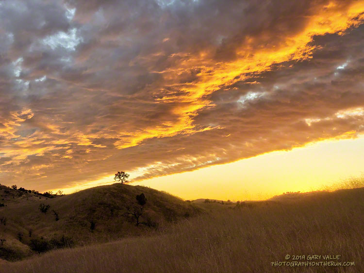
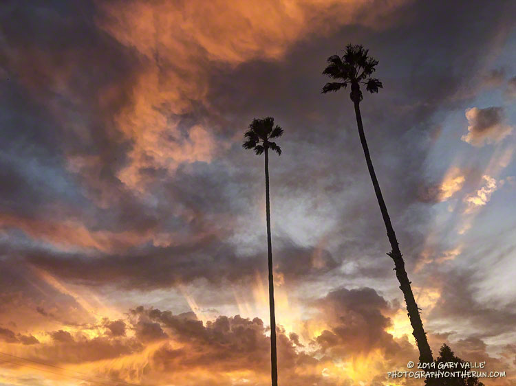
The upper-level low continued to influence the day’s weather, and while the low remained mostly offshore and didn’t generate any more showers in the West Valley, it did produce a colorful sunset!
Google discontinued its Google Earth API/Plugin in January 2017. That technology was used on PhotographyontheRun.com for 3D visualizations of trail runs, fire data, and other data.
I’ve been looking at alternatives since then, and have recently implemented an interactive viewer using the CesiumJS and Cesium ion components of the Cesium 3D Geospatial Platform. No browser add-on or plug-in is required. The viewer uses the Cesium World Terrain high-resolution global terrain tileset, with resolutions to 0.5 meter. The West Coast of the US is one of the areas covered by this resolution.
Following are example 3D visualizations of some of my recent runs. The views are interactive and can be zoomed, tilted, rotated and panned. Click/tap the “?” in the upper right corner for help manipulating the scene. Mileages and elevation gains/losses are approximate.
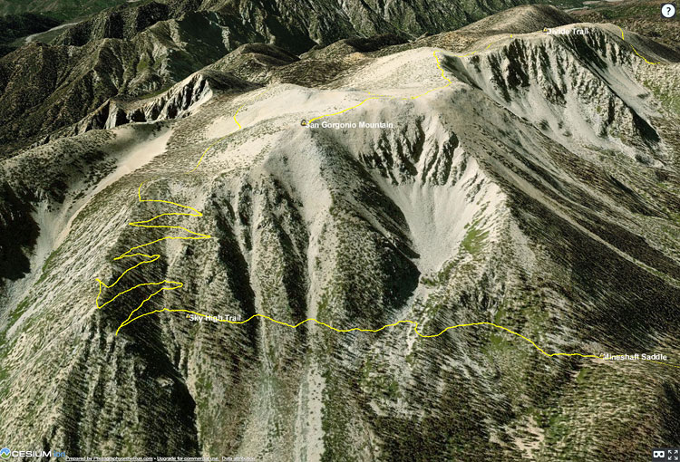
The initial view is of San Gorgonio Mountain from the northeast, showing the trail to the summit and the Sky High Trail. The large cirque held one of several glaciers on San Gorgonio Mountain. The GPS track is from a run in September.
Another view of San Gorgonio Mountain with the 2015 Lake Fire burn area added. The initial view is from the northwest. The GPS track is from my run in September.
The initial view of this popular loop is from the northeast. This variation starts/ends at the Cistern Trailhead on Mulholland Hwy. The GPS track is from a run of the loop in September.
The initial view is from the Buckhorn (east) side of the loop. The loop includes a segment of the PCT in Cooper Canyon. The GPS track is from a run in October.
The initial view is from the northeast, on the Valley side of the route. The Musch, Garapito and Bent Arrow Trails were done on the way back from Parker Mesa. The GPS track is from a run in October.