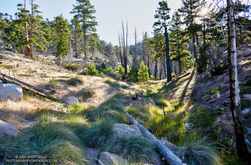
Approaching Waterman Meadow on the Three Points – Mt. Waterman Trail
You know what they say about making assumptions. Did the Three Points loop around Mt. Waterman today (July 25), and assumed that water would be available at Buckhorn Campground. In a normal summer that would be a reasonable assumption, but this has been anything but a normal summer.
Running down through the campground, I thought it was strange that many of the spaces were empty. Following the signs that said, “Day Use Parking,” and then “Burkhart Trail,” I stopped at a spigot across from some restrooms.
Routine water tests were pending.
Surprise, surprise! The stapled-on Forest Service sign said, “Non-potable water. Please boil water for a minimum of 5 minutes before using.”
Later, I talked to a ranger and learned that the campground had just reopened on Friday! He said routine tests on the water system had to be completed before the water could be deemed potable.
So I had a choice to make. I was doing the loop counterclockwise, which put Buckhorn at about mile 9 of a 20-mile loop. The second half of the loop — on the PCT — can bake on a hot day, with the climb out of Cooper Canyon being especially blistering.
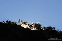
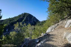
Morning sun crests a ridge on Waterman Mountain.
So far, the run had gone well. The Mt. Waterman Trail between Three Points and the turn off to Twin Peaks had been in excellent shape. No trees had blocked the trail, and the wildflowers and ferns at Waterman Meadow had been extraordinary. Like last year, a rejuvenated spring about 0.5 mile west of the Twin Peaks junction had water. (Not aware of the situation at Buckhorn, I didn’t top off my water.)
As usual, the run down the Mt. Waterman Trail to Highway 2 was excellent. A lot of people were enjoying the hike to the peak, but no more than is typical for that trail in the summertime.
Which brings me back to Buckhorn and my water problem. I could have shortcut the loop by skipping Cooper Canyon and running directly to Cloudburst Summit on Highway 2. That would have shortened the loop by 5 miles. But the day wasn’t super-hot, and there were several places where water could be used for cooling — even if I couldn’t drink it.
Reconfirming how much water I had left, I squeezed the Camelbak(TM) in my pack, and then started running down the Burkhart Trail into Cooper Canyon.
By maintaining a comfortable pace, and using seeps for cooling, my water lasted until I was within sight of the Three Points parking lot. This probably wouldn’t have been the case on a hot day.
While doing the Bulldog Loop earlier this year, I encountered an enthusiastic hiker who commented, “Aren’t the wildflowers amazing?”
He added, “There are so many, uh… What’s it called? You know, the one that smells like maple syrup.”
“Do you mean Everlasting?” I asked.
“Yea, that’s it! California Everlasting,” he exclaimed.
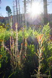
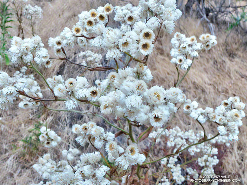
That’s what people remember about California Everlasting — the leaves smell like maple syrup.
The somewhat nondescript plant is especially abundant this year.
As suggested by its name, California Everlasting (Pseudognaphalium californicum) can be found along trails in Southern California chaparral and coastal sage-scrub just about any month of the year.
The plant looks like it is blooming in the title photo, but each “petal” is a botanical structure called a phyllary. The phyllaries form a protective covering around a disc of tiny flowers as they develop. Here is a closer view.
The plant dries out in the Summer, but the flower-like structures often remain – an everlasting dried flower arrangement.
The photos are from this morning’s run to Calabasas Peak on the Secret Trail.
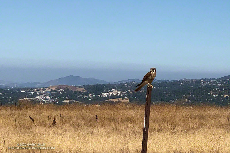
My weekday runs at Ahmanson Ranch will frequently include a dirt road on the east side of Lasky Mesa that is part of the Mary Wiesbrock Loop. There is a fence line along the road, and almost without fail, I’ll see a bird or two on the fence.
The most common fence-sitting birds on this stretch of road have been the Say’s phoebe, western kingbird, mourning dove, and lark sparrow. Occasionally, I’ve also seen a kestrel or northern harrier taking in the view.
While phoebes and kingbirds sometimes play bird games, hop-scotching from fence post to fence post, raptors are exceptionally wary and fly away at the slightest provocation.
Today, I was running down the road and spotted a dove-sized bird sitting on a fence post. As I approached, I could see that it was a kestrel and expected it to make a quick exit.
Slowing to a walk, I stopped directly across the road from the small falcon. It was about 20′ away, and didn’t take flight.
The only camera I had was my iPhone, so it had to do. I slowly took the phone out of my pack and tapped a camera app. The bird cooperated, and I took a few photos. But I wasn’t close enough.
Had the kestrel flown? I selected the 2X view. Still there. I took a couple more photos.
Finally, the falcon became impatient, and in a characteristic motion, jumped into flight.
This year I’ve seen kestrels on Lasky Mesa frequently, and suspect the mesa is about the right size for a mated pair’s territory.
Update August 5, 2020. The kestrels have been very wary lately, flying away just when I get within camera range. Here’s a photo of the male kestrel from this afternoon’s run.
Update July 30, 2020. I’ve seen at least one of the Kestrels just about every time I run on Lasky Mesa, but have been unable to approach anywhere near as close as described above. Here’s a photo of one of them perched on a fence post on the south side of Lasky Mesa. It was taken with the equivalent of a 230 mm telephoto lens. Based on its coloration in flight, it appeared to be a female.
After so many years of doing the Angeles National Forest Trail Race, I’m not sure I even had a choice. At about 7:00 a.m. on Saturday, July 11, 2020, I found myself running down Mt. Wilson Road.
It was odd not to be surrounded by runners. Gary Hilliard had not done his one-of-a-kind pre-race briefing. There had been no hugs or handshakes at the start of the run. No runners commented on the temperature or talked about past or future races. Thanks to COVID-19, the 2020 ANFTR race had been canceled.
But the mountains and trails were still there, and by running the 25K course, I could get a good idea of what the 2020 race might have been like.
I was not racing the course. The forecast was — of course — for a hot day. And in these covid times, I was running solo. I was out to enjoy “being there” — seeing what I could see, learning what I could learn.
View into the canyon of the West Fork San Gabriel River from Mt. Wilson Road.
Mt. Wilson road is exceptionally scenic, and on the way down to Eaton Saddle, I stopped several times to take photos. The canyon of the West Fork San Gabriel River is spectacular. It’s a long way down to the bottom, and I always marvel at its depth. The 2600′ climb out of that canyon is the crux of all the ANFTR courses, and as I would later discover, would be especially challenging today.
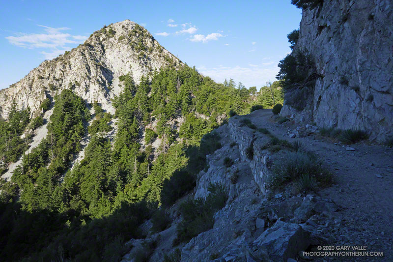
Rugged San Gabriel Peak marked the turn onto Mt. Lowe fire road at Eaton Saddle. From here, the course follows the fire road through Mueller Tunnel and up to the saddle between Mt. Markham and San Gabriel Peak. The first significant climb of the course begins here. Much of the 650′ climb up the single-track trail is in the shade. If it’s already warm here…
Looking back at San Gabriel Peak from near the top of the Lower San Gabriel Peak/Bill Reilly Trail.
The single-track trail leads up to the Mt. Disappointment service road. The high point of the 60K, 50K and 25K courses — about 5780′ — is along this short stretch of road. For the 25K course it’s (almost) all downhill from here to West Fork. A winding, and usually dusty, single-track trail turns off the service road and leads down through scrub oaks to Mt. Wilson Road, just above Red Box.
In the actual event, runners doing the 50K and 60K turn left onto the Gabrielino Trail at Red Box and do a 15+ mile circuit around Strawberry Peak. Runners doing the 25K turn right and continue down Rincon – Red Box Road to West Fork.
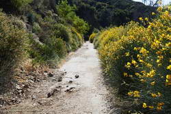
Spanish broom along Rincon – Red Box Road near Valley Forge Campground.
The time of day when you do the 5+ mile segment from Red Box to West Fork makes a huge difference. On hot race days, such as in 2012, 2017 and 2018, the road bakes and in-the-sun temps can reach well over 100 degrees. (This isn’t the only part of the 50K/60K course that can be hot!)
Because I was running the 25K course, I was on Red Box road relatively early. It was probably in the 90s in the direct sun, but there were still some cool stretches of shade. In years with average or above-average rainfall, there are usually a few little stream crossings where capfuls of water can be dumped on your head. They were flowing today. Usually at West Fork there is a hose/shower setup to use for cooling.
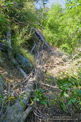
There was a collapsed sycamore on the trail near the spring, but it didn’t look like it was going to be much of a problem. On the run down to West Fork, I’d noticed an increasing number of trees on the road. About a mile from West Fork, a large oak had fallen down a road-cut, blocking the road and bringing with it a pile of debris.
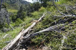
Mass of trees down on the Gabrielino Trail.
Leaving West Fork on the Gabrielino Trail, I worked around the fallen sycamore and then continued up the trail. Within yards there was another fallen tree, then another, and another. The number of trees down on the trail was remarkable. Part of the reason is that the Forest Service isn’t currently allowing volunteer groups to do trail maintenance. I’m sure ANFTR R.D. / AC100 Trail Boss Gary Hilliard is going crazy not being able to work on the trails.
But I think there’s more to it than trail maintenance. There are far more trees down on the trail than I’ve seen in other years. The area is covered in scrub oaks and bay trees that were killed by the Station Fire. I suspect the same storms that broke and toppled trees in the San Gabriels high country over the Winter, toppled dead trees here as well.
Trees down on the Kenyon Devore Trail.
It became a mantra — over, under, around or through? Over, under, around or through? Tree after tree. It was warming up, and the extra work of battling the trees added to the effort. On the Gabrielino segment of the route, trail users had trimmed some small limbs from a few of the trees, and that helped.
I thought that once I got out of the scrub oaks and into the forest proper, there wouldn’t be so many trees on the trail. That was mostly true, but there were still several tree challenges higher on the Kenyon Devore Trail. One large log was perched across the trail at the top of a steep gully. I didn’t want to slip and started to use the log for hand-holds. Bad idea! Who knew how little force would be required to dislodge the tree.
Eventually, I reached a point on the trail where I could just hike and didn’t have to climb over, under, around or through anything. What a relief!
It’s difficult to estimate just how many trees were down on the trail. Fifty? Sixty? I have no idea. There were many small trees I didn’t even think about, and there were multiple trees down in some spots. However many there are, if another Winter passes before the trails can be maintained, it will require a massive effort to get them cleared.
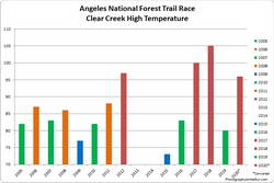
The highest temperature recorded at Clear Creek on the day of the ANFTR/Mt. Disappointment races for 2005-2020. The 2020 race was canceled.
Based on the temperatures recorded at the Clear Creek RAWS, this would have been the #3 or #4 hottest of the ANF Trail Races. Compared to the other hot races, temps were a few degrees cooler early, but reached similar temperatures by mid-afternoon. The Clear Creek RAWS recorded hourly temperatures as high as 96°F and hourly fuel temps as high as 121°F.