Caught in a Thunderstorm on Rocky Peak

Sun and gathering clouds on Rocky Peak Road before a strong thunderstorm
Sun and gathering clouds on Rocky Peak Road

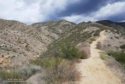
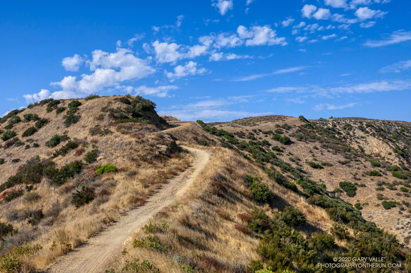
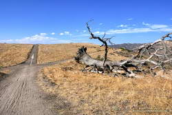
Rocky Peak Road is an exceptionally popular hiking and biking trail that starts at Santa Susana Pass, on the north side of the 118 Freeway. Regardless of the time of day or weather I ALWAYS see someone on this trail.

The plan for this afternoon’s run was to do an out and back on Rocky Peak Road to the top of the Chumash Trail (3.8 miles) or to Fossil Point (4.8 miles).

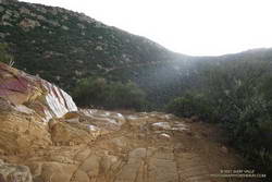
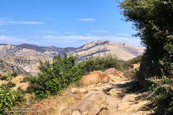
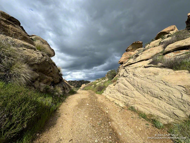
Another runner was finishing their workout as I started up the initial steep climb. Glistening in the warm sun, runoff from yesterday’s storm streaked some of the sandstone rocks, and ephemeral streams gurgled in the ravines and gullies.

Thanks to the sandstone geology, the dirt road wasn’t as muddy as most other local trails would be. Although heavily eroded from numerous Winter storms, it was still near the top of my list of places to run during periods of wet weather.

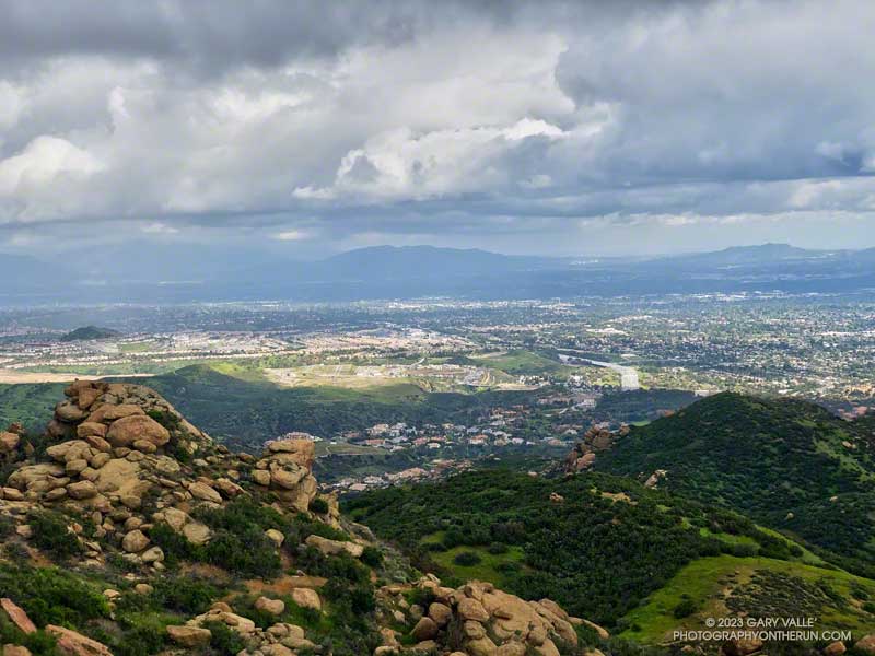
In the aftermath of yesterday’s storm the weather was spectacular. The temperature was warm enough to run in shorts and short-sleeves but still comfortable chugging up Rocky Peak Road’s steep hills. Puffy cumulus clouds filled the sky, creating postcard views at every turn.

Clouds developing over the San Fernando Valley (thumbnail)
Clouds developing over the San Fernando Valley. Click to enlarge.

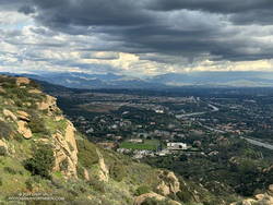
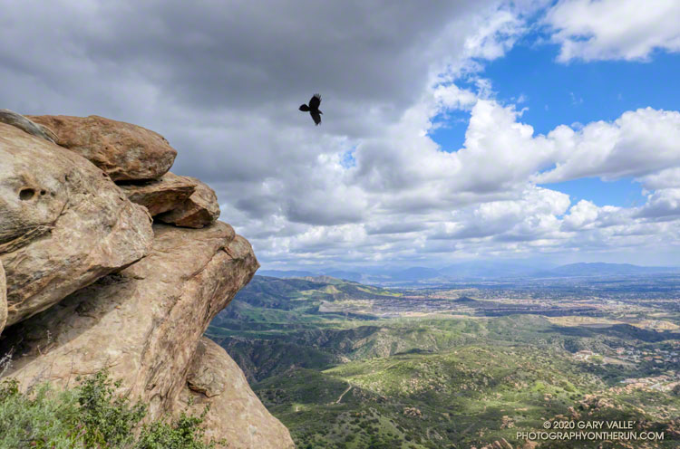
More focused about getting up the hill than any weather concerns, I continued past the top of the Hummingbird Trail and through a gap in the rocks to a section of road with a good view of the San Fernando Valley and San Gabriel Mountains.

I’d been in a situation similar to this several times on Rocky Peak. As a storm moves east from Los Angeles, energy circulating around the low can sometimes result in “back-door” precipitation. In this scenario, clouds build-up over the mountains to the north and then drift over the San Fernando Valley, producing showers — and sometimes — thunderstorms.

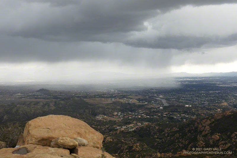
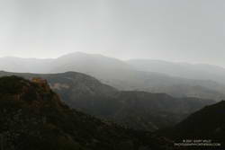
But today’s scenario was a bit more complicated. A much larger area, extending east to the San Gabriel Mountains, was rapidly destabilizing. What had been a picturesque sky at the start of the run was now congested and ominous. The question wasn’t so much if it was going to rain, but if a thunderstorm was going to develop.

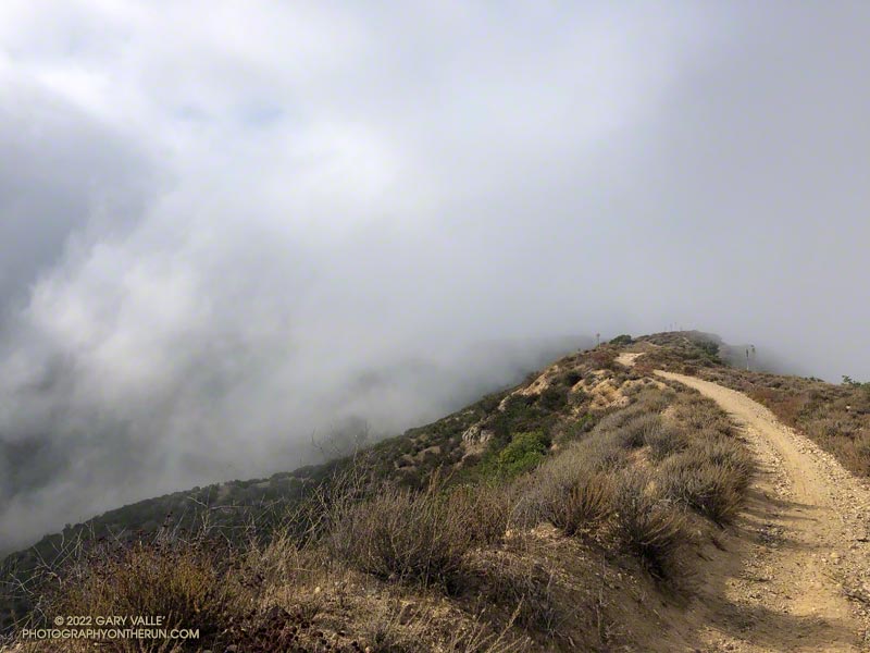
As I continued up the road, the sky darkened, the temperature cooled, and the wind became more gusty and fitful. A little chilly, I pulled on my arm sleeves. I laughed nervously as I mistook the roar of a passing jet for thunder. That was a jet, right?

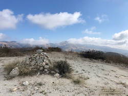
When people say they are “doing Rocky Peak,” they are often referring to a high point on Rocky Peak Road that is west of the actual peak and about 2.4 miles from the trailhead. The final climb to this high point is a good one — gaining about 450 feet over three-quarters of a mile.

The road on this stretch is oriented in such a way that the terrain hides the view to the north. I was anxious to get to the top of the hill so I could get a better idea of what the weather was doing. As I worked up the road, I would occasionally feel the cold splash of a raindrop on one leg or the other.

Doppler radar of strong thunderstorm over Rocky Peak (Thumbnail)
Doppler radar of strong thunderstorm over Rocky Peak. Click to enlarge.

Nearing the top, I thought, “I may get wet, but at least there’s been no thunder.” Within seconds of that proclamation, and as I reached the highest point, there was a long, loud, crackling peal of thunder.

One look at the sky and all thoughts of continuing to the Chumash Trail were gone. I turned around and started running down the hill, hoping to avoid the worst of the storm.

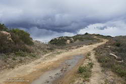
First one pea-sized hailstone hit the ground, then another, and then a sleety barrage of rain and hail poured from the sky. Instantly soaked, I shuddered as thunder echoed overhead and cold rain ran down my back. Muddy water flowed in rivulets down the sodden road and I cautioned myself to run fast, but not too fast.

I didn’t expect to outrun the storm, but hoped I might move to a part of it that was less intense. And that’s what happened. As I descended, the deluge gradually diminished. Most of the activity seemed to be behind me and a little to the east.

Severe thunderstorm over Porter Ranch - Northridge area (Thumbnail)
Severe thunderstorm moving into the Porter Ranch – Northridge area. Click to enlarge.

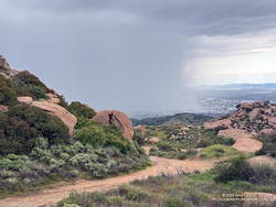
By the time I got down to the Hummingbird Trail, it was only sprinkling. The strong cell that had been over Rocky Peak had drifted southeast, and was now over the Porter Ranch – Northridge area.

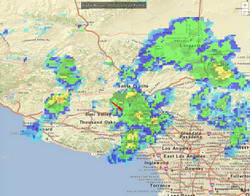
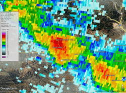
National Weather Service Doppler Radar tells the story. At the start of the run there were scattered, mostly weak echoes. At 3:06 pm, as I was starting up the last long hill, a cell northwest of Rocky Peak was developing and drifting southeast. Over the next 16 minutes the cell continued to move southeastward and strengthen, and at 3:22 pm was over the Rocky Peak area. I turned around and started down as the cell moved into that area.

The cell over Rocky Peak continued to strengthen, and at 3:39 pm had drifted over the Porter Ranch – Northridge area. At 3:44 pm the NWS issued a Severe Thunderstorm Warning for Western Los Angeles County.

Here are a GOES-18 satellite loop and Doppler Radar loop that show the development and track of the Rocky Peak thunderstorm.

Some related posts:
Rainy Weather Running on Rocky Peak Road
Running Between Raindrops: Chumash Trailhead to Rocky Peak
Thunderstorm

Rainy Weather Running on Rocky Peak Road

San Fernando Valley from Rocky Peak Road.

I like splashing through streams as much as anyone does, but today I wanted to try and keep my shoes and socks dry. This Winter that’s been surprisingly hard to do.

Weekdays, I often run from the Victory trailhead at Ahmanson Ranch over to Las Virgenes Canyon and back. But it had rained in the Los Angeles area for four days straight. There was just no question that Ahmanson was going to be wet and muddy, and Las Virgenes Creek would be too wide to jump. I’d have to wade the creek crossings — again.

Paintbrush (Castilleja affinis) along Rocky Peak Road

That’s why this afternoon, I was doing an out-and-back run on Rocky Peak Road from the 118 Frwy trailhead. As a result of the area’s sandstone geology, Rocky Peak Road is usually a pretty good place to run during periods of wet weather. For one thing, there are no creeks to cross. Plus, the rocky and sandy road doesn’t have many areas of “glob on your shoes” mud. It also has excellent views of the San Fernando and Simi Valleys and surrounding mountains.

My turnaround point today was the top of the Chumash Trail, which is a little less than four miles from the Rocky Peak trailhead. I sometimes continue past the Chumash Trail another mile to Fossil Point.

Today, there was one short, muddy stretch that could be mostly avoided and a few large mud puddles I could walk around. At the end of the run I didn’t have to switch shoes to drive home!

Some related posts: A Bear on Rocky Peak Road, Chilly Rocky Peak, Mountain Lion Tracks on Rocky Peak Road, Rocky Peak Vernal Pool

A Bear on Rocky Peak Road?

Low clouds spilling over Rocky Peak Road near the Chumash Trail.

Wait a minute… I stopped running down the hill and walked back to look at the sizable pile of scat.

I was on Rocky Peak Road, at about mile 3 of an extended version of the Chumash – Las Llajas loop, and just past the top of the Chumash Trail.

Bear scat on Rocky Peak Road. October 2022.
Bear scat on Rocky Peak Road. Click for a larger image.

No doubt about it. It was bear scat. The bear had been eating holly-leaved cherries, and the scat was full of cherry pits. Over several decades of running Rocky Peak Road, this was the first time I’d seen evidence of a bear in the area.

Bears aren’t particularly common here, but they are seen from time to time. I wondered if this was the bear that had been discovered in the kitchen of a Simi Valley home in early September.

Bears have also been captured on local trail cams. In December 2015, the NPS photographed a bear and her cub feeding on the carcass of deer in the Santa Susana Mountains. Even more remarkable, in July 2016, a bear was photographed in Malibu Creek State Park by an NPS camera trap.

This morning, I looked for bear tracks around the scat, but thunderstorms and bike traffic had erased them. After taking a couple of photos, I continued toward the high point of the loop, “Fossil Point.”

Cairn at Fossil Point, the highest point of the Chumash - Las Llajas Loop.
Cairn at “Fossil Point” — the highest point of the Chumash – Las Llajas Loop.

What had started as a very foggy morning was transitioning to a cool Fall day with a mix of sun and clouds. From the cairn at Fossil Point, Oat Mountain was still partially shrouded by clouds. Below the overlook, I spotted a couple of mountain bikers working up the road. The ride up Las Llajas Canyon has become a popular e-mountainbike ride, and e-bikes would be the only type of bike I would see on my way down the canyon.

The run down Las Llajas Canyon was pleasant and fast-paced. Lately, I’ve been doing a variation of the loop that jumps over to the Marr Ranch Trail using a trail that splits off the Coquina Mine trail. This route gets you up and out of the canyon and onto a ridge with good views of the surrounding terrain. It’s a bit more adventurous and adds a little mileage and elevation gain to the usual loop. The Coquina Mine trail is easy to miss — it branches off Las Llajas Road after passing the towering cliffs.

Here’s an interactive, 3D terrain view of a GPS track of the extended Chumash – Las Llajas loop. The map can be zoomed, tilted, rotated, and panned using the navigation control on the right. Track and placename locations are approximate and subject to errors. Poor weather and other conditions may make this route unsuitable for this activity.

Some related posts: Chumash-Las Llajas Loop, Not So Flat Las Llajas Canyon, Exploring Las Llajas, Marr Ranch Wildflowers

Running Between Raindrops: Chumash Trailhead to Rocky Peak

Rain in the San Fernando Valley from Rocky Peak. March 12, 2021.
Rain in the San Fernando Valley from Rocky Peak

Was that thunder? I warily eyed the dark clouds over the mountains and pondered the situation.

I was about halfway to the top of the Chumash Trail and was planning to run along the crest to Rocky Peak. The run had started in short sleeves and sunshine, but it was pretty obvious that wasn’t going to last.

Chumash Trail about a mile from the trailhead

A cold upper-level low had brought badly needed rain to the area for the past two days. The low was moving off to the east, but there was still a chance of afternoon showers and maybe even a thunderstorm.

It was the “thunderstorm” part that I needed to pay attention to. I had enough gear to deal with a downpour and cooling temps, but electrical storms are no fun at all.

I decided to continue to the top of the Chumash Trail and reassess. As I worked up the trail, I pictured the counterclockwise circulation around the low, and how convective cells develop over the mountains and then dissipate as they drift south. The concern was that the cells don’t always dissipate.

Rocky Peak Road near Rocky Peak

It looked like things weren’t getting any better at the top of the Chumash Trail, but it wasn’t worse either. I hadn’t heard any thunder for a while, and most of the activity seemed to be a few miles to the west and east. Having been starved of stormy weather for much of the rain season, I turned right on Rocky Peak Road and headed south toward Rocky Peak.

The run from the Chumash Trailhead to Rocky Peak is a challenging mix of technical single-track trail and hilly fire road. There are wide-ranging views of Simi Valley & Simi Hills, the San Fernando Valley, Santa Monica Mountains, Ventura County mountains, and San Gabriel Mountains. On a clear day, the view can extend to the Channel Islands, Saddleback, and San Jacinto Peak.

NOAA radar mosaic Rocky Peak March 12, 2021.
NOAA radar mosaic at the time I was on Rocky Peak

The actual turnaround point for a run to “Rocky Peak” varies. Some like to turnaround at the high point of Rocky Peak Road that is near Rocky Peak. Most of the time, I turnaround at a viewpoint that is at the end of a spur trail that branches off from the high point of Rocky Peak Road. From time to time, it’s fun to hike over to Rocky Peak and scramble to the top. That’s a bit more involved and requires some route-finding.

I felt the first raindrops as I reached the high point on Rocky Peak Road and turned onto the spur trail that leads to the overlook. There was some increased development to the east, but it looked like there would be enough time to get over to Rocky Peak, take a couple of pics, and then head back.

Oat Mountain, shrouded by rain

I felt a little exposed on top of Rocky Peak. I hadn’t heard any thunder for the past hour, but a cell to the east was spouting heavy rain over the San Fernando Valley, which meant there was probably enough development to produce lightning. I took the title photo and a couple of others and hurriedly descended from the peak.

Back on Rock Peak Road, the sprinkles increased, and the showers became more steady as I ran north toward the Chumash Trail. Under the dark clouds, a raven perched on a large pinnacle cawed incessantly, either enjoying the rain or complaining about it. In the distance, a siren wailed down in the valley. It was cold, and I was very glad to have an extra shirt, sleeves, gloves and a light rain shell.

Mix of sun and rain on the Chumash Trail
Mix of sun and rain on the Chumash Trail.

As I began the descent of the Chumash Trail, the sun briefly broke through the clouds, reflecting brightly on the wet sandstone rocks. I breathed deeply, relishing the smell of the cleansed air and wet chaparral, and continued down the trail.

Here’s an interactive 3D terrain view of my GPS track. Over the run, the temperature sensor on my pack recorded a drop of about 30 degrees — from around 70°F at the start of the run to about 40°F when the showers began! Here’s what a NOAA Radar Mosaic looked like at the start of the run and when I was on Rocky Peak.

Related: Chumash Trail, Rocky Peak, Thunderstorm

Chumash-Las Llajas Loop

Rocky Peak Fire Road between the Chumash Trail and Fossil Point

Update of a post from December 30, 2006.

The Chumash-Las Llajas Loop is a scenic 9.3 mile trail run in the eastern Simi Valley. Run counterclockwise, it combines a  strenuous climb on a single-track trail and fire road with a fast-paced 4-mile downhill on a dirt road. The cumulative elevation gain/loss on the loop is about 1600′.

View of Oat Mountain from near the top of the Chumash Trail.
Nearing the top of the Chumash Trail

I like to do the loop starting at the Las Llajas Canyon trailhead on Evening Sky Drive. A short jog up Evening Sky Dr., then across a field, and you’re on your way up the Chumash Trail. From this point, it’s an approximately 1000′ climb over 2.7 miles of rocky trail to Rocky Peak fire road.

After turning left (north) on Rocky Peak fire road, a short downhill is followed by three-quarters of a mile of climbing to “Fossil Point.” A short detour off the main fire road leads to a cairn marking the high point. From here there is a panoramic view of Oat Mountain, San Fernando Valley, San Gabriel Mountains, Santa Monica Mountains, Simi Valley, Boney Mountain, Channel Islands, and Ventura Mountains.

Exposures of fossil shells are found near the high point. According to the area’s Dibblee geology map, these may have been deposited in shallow marine lagoons a couple million years ago.

From the high point, the loop continues north on Rocky Peak Road. At first, it descends steeply, then climbs to a hilltop with a few valley oaks. Partway up the hill, a roadcut reveals the long roots of the chamise plants on the hillside.

Road connecting Rocky Peak Road to Las Llajas Canyon.

Following a short downhill, the road continues past a fallen valley oak that was killed by the 2011-2015 drought. There is a fork in the road here. The road connecting to Las Llajas Canyon goes up a short hill to an overlook of the canyon. From the top of the hill, there are more than 4 miles of downhill through the winding canyon. There used to be oil field equipment on the connector between Rocky Peak Rd. and Las Llajas Canyon, but it has been removed.

If the creek in the canyon is flowing, there are several places where the (usually) small stream crosses the road. In the Spring and early Summer, many species of wildflowers can be found in the canyon.

Cattle on the Las Llajas Loop

Some of the wildlife, and not-so-wild animals, I’ve encountered on the loop include rattlesnakes and other snakes, deer, longhorn cattle, roadrunners, and a kangaroo rat. Although others have seen mountain lions in the area, I’ve only photographed their tracks.

The loop ends with a short, steep climb up a paved road. At the top of the hill, turn left to return to the trailhead.

Explore the scenery and terrain on the Chumash-Las Llajas Loop trail run using our high resolution,  interactive, 3D viewer. The imagery is so detailed, it’s almost like being there! To change the view, use the control on the upper right side of the screen, the CTRL key and your mouse, or touch gestures. Track and placename locations are approximate and subject to errors. Poor weather, and other conditions may make this route unsuitable for this activity. (It is also possible to start the loop at the Chumash Trail trailhead at the end of Flanagan Dr.)

The title photo is a section of Rocky Peak fire road between the top of the Chumash Trail and Fossil Point. It is from a run on October 6, 2020.

Some related posts: Chumash Trail Rocks & Snow, Exploring Las Llajas, Marr Ranch WildflowersThings Found on the Chumash Trail