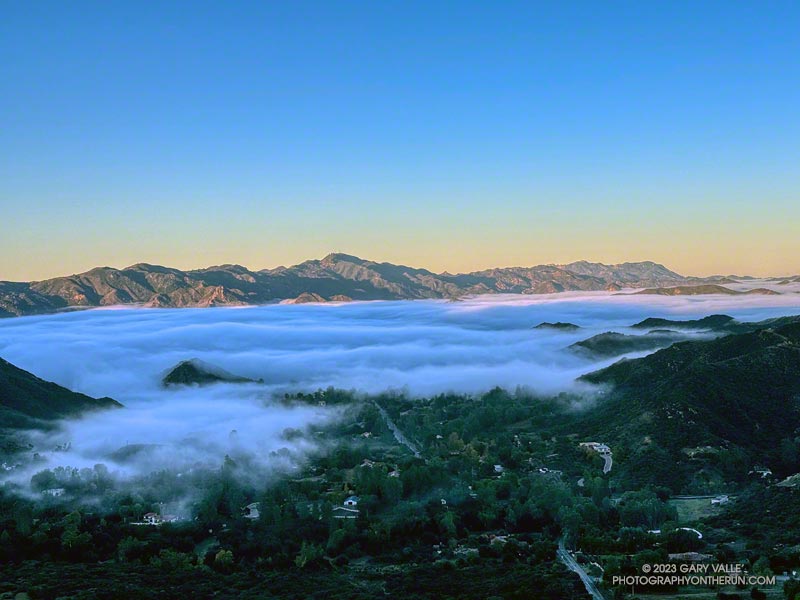
The sun had risen, casting a warm morning light on the Santa Monica Mountains. Overnight, low clouds flowed inland through Malibu Canyon, emphasizing the peaks and covering the valleys.
Backbone Trail below Saddle Peak.
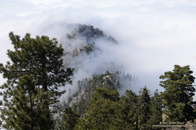
I had just started up Topanga Lookout Ridge and was less than a mile into the Topanga Lookout Ridge Loop. Rain had muddied the ground and cleansed the sky, producing crystal clear views in every direction.
The view of the western Santa Monica Mountains extended from the top of the Tapia climb on Mesa Peak Motorway, past Castro Peak, to Boney Mountain and the highest peak in the Santa Monica range — Sandstone Peak.
In my mind, I traced the route of the Backbone Trail along the crest. My route would take me to the Backbone Trail, but this morning I would enjoy running only a few of its sixty-eight spectacular miles.
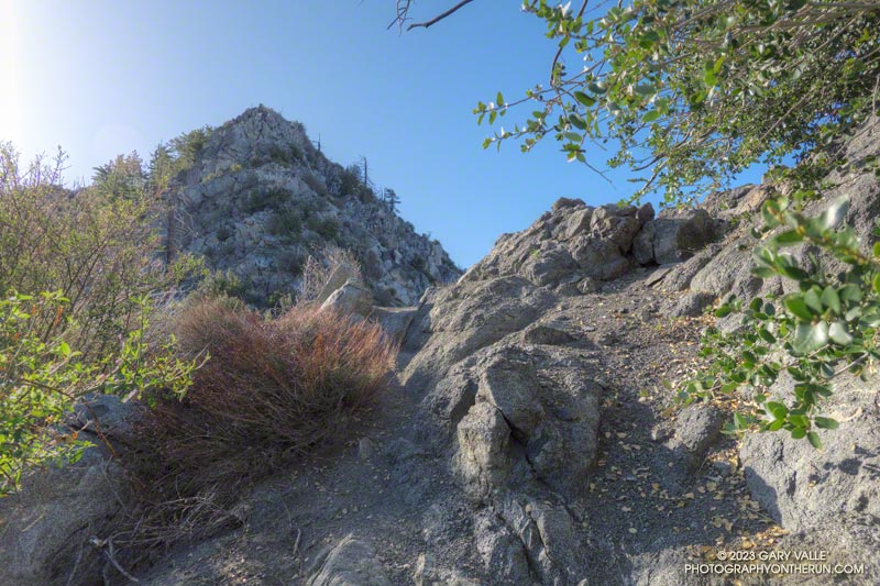
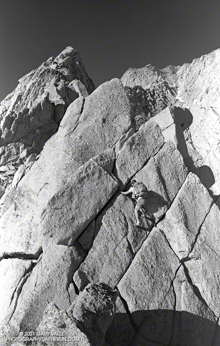
The northwest ridge of Strawberry Peak just before the Class 2-3 rock climbing segment.
Usually, I prefer to start the Strawberry Peak Summit Loop at the Colby Canyon Trailhead on Angeles Crest Highway. But it had been a while since I’d done the loop from Clear Creek, and I was feeling a little nostalgic. One of the aid stations for the ANFTR/Mt. Disappointment race is at Clear Creek, and the course climbs Josephine Fire Road.
I was also curious how my time to Josephine Saddle using the fire road would compare to the direct route up the Colby Canyon Trail. As it turned out, at a moderate pace it was about the same either way.
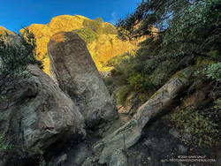
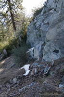
Foliated rock along the use trail to the northwest ridge of Strawberry Peak
The use trail up from Josephine Saddle was in decent condition. It looked like it may have recently had a snip here and there. Part way up the path, an outcrop on the ridgeline provides a good warmup for the climbing higher up. The circuitous path eventually ends at the base of the steep, jumbled northwest ridge of Strawberry Peak. I was surprised to find two small patches of snow here.
It’s difficult to describe the route on the ridge since there are many variations. It’s not fear-mongering to say that people get into trouble on this section. A common comment about this segment is, “Don’t climb anything sketchy or difficult.” But what is an easy scramble for one person may be nearly impossible for another. With 50+ years of rock climbing experience, I still remind myself not to climb up anything I’m not 100% sure I can climb down. If you don’t have “real” rock climbing experience, go with someone that knows the route.
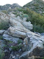
Small patches of snow on the NW side of Strawberry Peak on April 30, 2023.
Following a wet, snowy, cold Winter, I took extra care while climbing. Solid holds and blocks can sometimes be loosened over the Winter and fail unexpectedly. This morning, I didn’t notice any obvious changes on the route I climbed.
The setting changes dramatically on the east side of Strawberry Peak. You go from the cool shadows of a steep, rocky face with (typically) no one around to a sunny, sandy, busy summit and trail.
As I approached the summit, a couple of people were setting up to do a video for a vlog. Another person had just reached the top, and another hiker wasn’t far behind. With snow in the high country, Hwy 2 still closed at Red Box, and the Bobcat Fire Closure still in effect, the trail up Strawberry was a popular option. The question of the day from the people coming up was, “How many false summits are there?”
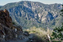
Looking across the canyon to the Gabrielino Trail below Red Box, and Supercloud Canyon
Overall, the Strawberry Peak Trail was in reasonable shape. The trail needed a little work in a few places, but as far as mountain trails go, its condition was about what you would expect. In several places, the trail was carpeted with the remnants of old yucca leaves. Very nice!
Just before reaching Red Box, I snapped a photo of the snow on Mt. Baldy. At Red Box, all but one parking space was taken, and that one was snagged by an arriving car.
As I started down the Gabrielino Trail from Red Box, LASD Air Rescue 5 began to orbit overhead. Apparently, there had been yet another vehicle accident on Angeles Crest Highway. It wasn’t long until I heard the whaling sound of sirens coming up the canyon.
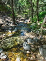
Upper Arroyo Seco at Switzer’s Picnic Area.
Some trailwork had been done on the upper half of Gabrielino Trail between Red Box and Switzer’s. Quite a few small trees and limbs had been removed from the trail, and the bushes trimmed. Most of the work (as of today) ended at mass of fallen trees halfway down the trail.
Upper Arroyo Seco was flowing. The sound of water plunging over the debris dams made the flow seem higher than it was. There were a couple of minor creek crossings.
Switzer’s was busy — as usual. To finish the loop, I walked up the stairs to the access road and hiked up to the start of Nature’s Canteen Trail. It was a bit overgrown, but I was back at Clear Creek in a few minutes.
The run up the Phantom Trail from Mulholland Highway and out Heartbreak Ridge is a fun adventure all on its own. When you first see Ladyface from the Phantom Trail, it seems like the trail isn’t going to go anywhere near the peak. But a series of ups, downs, and arounds does eventually get you to an overlook above the junction of Kanan & Cornell Roads. If you were to turn around at this point, the out and back would total a little over 8 miles.
Continuing down to Kanan Road and doing a counterclockwise loop on Ladyface — ascending the East/Northeast Ridge and descending the East/Southeast Ridge — adds another 3.5 miles to the route, and ups the adventure quotient a notch.
I first climbed Ladyface by this route in 2010 and have done Ladyface many times since. It’s a “real” peak with all the pros and cons that come with such a peak. The route isn’t always obvious, and some scrambling using the hands is required. Some sections of trail are steep, gritty and slippery. The quality of the volcanic rock varies. The knobby rock is fun to climb, but can break unexpectedly.
Even with the Ventura Freeway buzzing below the peak, the views from Ladyface are spectacular. A panorama of the Santa Monica Mountains extends from Saddle Peak in the east to Boney Mountain in the west. On the opposite side of the mountain, Hines Peak, Simi Peak and the San Gabriel Mountains fill the scene. On a day with good visibility, San Jacinto Peak can be spotted, far to the east.
Here are a few photos taken along the way, and an interactive, 3D terrain view of the GPS track of my route. The map can be zoomed, tilted, rotated, and panned. To change the view, use the control on the upper right side of the screen. Track and placename locations are approximate and subject to errors. Poor weather, and other conditions may make this route unsuitable for this activity.
Phil Warrender climbing the first of a series of towers on the Northeast Ridge of Lone Pine Peak. July 11, 1982.
WARNING: The North and Northeast Ridges of Lone Pine Peak are long, complex, alpine climbing routes. Many people climb them without issue, but some are forced to retreat, bivi, or have other difficulties. Some have problems finding the descent routes. Depending on your mountaineering and rock climbing skills, the weather, and your judgement, these climbs can be a fantastic experience or an epic nightmare.
The soaring knife-edge ridges and sweeping granite faces of Lone Pine Peak are compelling features that mountaineers and rock climbers find irresistible. The North Ridge — the right skyline of the peak when viewed from the Owens Valley — is the most popular climbing route on the mountain. It was first climbed in September 1952 by A. C. Lembeck and Ray W. Van Aken. In the 1954 edition of the Climber’s Guide to the High Sierra, it was described as a long class 5 route requiring six pitons.
What’s old is new again, and with the rapid evolution of climbing in the ’70s, the North Ridge was rediscovered. I think I first heard about an “amazing ridge” on Lone Pine Peak out at Stoney Point. There was a group of us that bouldered at Stoney on Tuesday and Thursday and then climbed at Tahquitz, Suicide or JT on weekends. Periodic multi-day trips to the Needles, Yosemite, Tuolumne, and the Sierra rounded out our climbing routine.
Phil Warrender and I, along with other climbing partners, climbed the North Ridge many times. We’d drive up from L.A. after work, sleep at Whitney Portal, and would climb the ridge the following day. I don’t think I climbed the North Ridge by the same route twice. That was part of its attraction.
Because we were familiar with the approach and descent, climbed the ridge without a rope, usually didn’t have route-finding issues, and ran down most of the Meysan Lakes Trail, we were able to do the North Ridge comfortably in a day. Starting at the Portal 6:00 a.m., we typically made it back in the mid to late afternoon.
You can’t climb the North Ridge or look at Lone Pine Peak from the Owens Valley, and not think about climbing the Northeast Ridge. To our climbing eyes, the Northeast Ridge looked like it was going to be more difficult than the North Ridge. The Northeast Ridge looked sharper and the towers more dramatic. And, it looked like the ridge ended at a headwall.
Whether it was the perceived difficulty and the strenuous approach — or just random chance — nearly 30 years after the first ascent of the North Ridge, there was no record of the Northeast Ridge having been climbed.
Phil and I did a lot of rock climbing and mountaineering in 1982. That June, along with Rich Grigsby, we climbed Whitney Portal Buttress. Lone Pine Peak was across the canyon, and I think that’s when we decided we had to get on the Northeast Ridge as soon as possible. We scouted the approach and waited for the snow higher on the ridge to melt.
To give ourselves the most daylight for dealing with possible problems on the technical part of the ridge, we decided to hike the non-technical section in the afternoon, then bivi and start climbing early the next morning. One downside of this decision was that it was July, and we did the hike during the hottest part of the day.
Phil Warrender on an easy, but exposed, ramp on the Northeast Ridge of Lone Pine Peak. July 1982. Click for larger image.
To save weight we carried a minimum of “just in case” climbing gear. We took the good half of an 8 mm rope that had been damaged. We packed “swami belts” instead of climbing harnesses. The webbing was much lighter and more compact, and might come in handy if we had a problem. We took a few slings and maybe a nut or two. In a pinch we figured we could use natural protection or chock some appropriately shaped rocks. We hiked and climbed in approach shoes. Phil’s shoes were Nike Lava Domes. I don’t recall what shoes I used, but I do remember that the soles started to delaminate during the climb.
We each took a couple bottles of water. We thought there was a slight chance of finding an accessible patch of snow higher on the route, but that didn’t happen. There was a little snow in the gully between the Northeast and North Ridges.
We both carried (film) cameras. My camera (and maybe Phil’s) was a Pentax ME. At that time, I was shooting a lot of B/W film – rolling my own cartridges from a bulk roll of fine-grained 2415 Tech Pan film and developing it myself.
Serrated section of the Northeast Ridge of Lone Pine Peak. July 1982. Click for larger image.
The climb could not have gone more smoothly. It was a granite playground of ramps, towers, and feldspar dikes and crystals. Everything that looked like it might be a problem had a solution. My notes regarding the route were pretty sparse:
“Ramp on right of first major tower. Followed a dike on another. Traverse on shattered ledge/weakness on final headwall.”
Phil Warrender climbs a feldspar dike on the Northeast Ridge of Lone Pine Peak. July 1982. Click for larger image.
We never used the rope or any of the climbing gear. There were a few bouldering-type moves, but overall the climbing was surprisingly straightforward. The rock quality was generally good. The granite is peppered with large feldspar phenocrysts. These can make great holds, but can also pop unexpectedly.
Judging from the sun’s angle and shadows, it was around noon when I took this last photo high on the ridge. That would have put us on top about 1:00 p.m. It may have been earlier. Low on water, we briefly visited Lone Pine Peak’s summit, and then hiked south to the usual descent chute on the west side of the peak.
Hurrying down the scree, we thirstily drank from the first little stream we encountered. After rinsing off the granite grime at a nearby tarn, we found the Meysan Lakes Trail, and headed back to the Portal.
When I started up the trail from Vincent Gap (6585′), the thermometer on my pack read 36°F. For the first few switchbacks, the trail was immersed in cloud. Beneath the tall conifers, the sandy soil was dotted with droplets of moisture extracted from the fog.
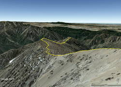
Google Earth image of GPS track down the South Ridge of Mt. Baden-Powell to Ross Mountain
I was on my way to Ross Mountain (7402′), one of the most isolated peaks in the San Gabriel Mountains. At the end of a rugged, 3-mile ridge extending south from the summit of Mt. Baden-Powell, the peak overlooks the vast canyons of the Sheep Mountain Wilderness.
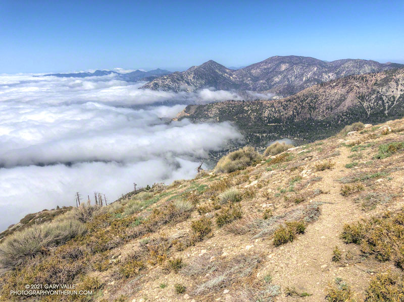
This morning, the canyons were filled with a 7000′ deep layer of stratus clouds. With a weak upper low over the Southern Sierra, the question of the day was whether the cloud deck would work up the ridge from Ross Mountain and completely envelop Baden-Powell.
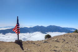
Summit of Mt. Baden-Powell. May 16, 2021.
Well acquainted with the trail up Baden-Powell, a combination of fast-hiking and slow-jogging put me on top in a relatively comfortable 90 minutes. I’d tried not to overdo the pace, knowing from previous experience that the return from Ross Mountain would be the tough part of the day.
From the summit of Baden-Powell, I gazed across the sea of clouds to Mt. Baldy. There was almost no snow on its steep north face. San Gorgonio Mountain was visible in the haze to the left of Pine Mountain and San Jacinto Peak in the gap between Dawson Peak and Mt. Baldy.
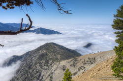
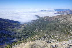
South Ridge of Mt. Baden-Powell with Ross Mountain partially visible in the clouds
Walking a little down the south side of Baden-Powell, I got my first good look at the South Ridge. Ross Mountain was nearly covered in clouds. Guessing that the deck of clouds might deepen, and a few minutes might make the difference of being in the clouds or out, I started to jog-lope-shuffle down the initial steep slope.
The title photo was taken a bit past Peak 8375, about 1.7 miles from Baden-Powell and 1.2 miles from Ross Mountain. At that time the clouds were spilling over the ridge near Peak 7407 and Peak 7360+, and around Ross Mountain.
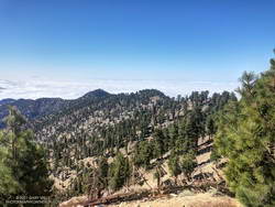
Into the clouds near Peak 7407
The clouds added an aesthetic element to the adventure, as well as a little uncertainty. They accentuated and embellished the terrain, while threatening to make the conditions wet, cold and disorienting. Being familiar with the route helped me to enjoy the experience more than the concerns.
After navigating the false summits along the final stretch of ridge, I finally reached Ross. And, of course, it was in the clouds. That was the tradeoff for the spectacular views of the clouds along the ridge.
I didn’t spend much time on the summit. The more time I could spend out of the clouds, the more enjoyable would be the 2200’+ climb back to Baden-Powell.
It took a little over two hours for the clouds to chase me back up the ridge, but only an hour to run the four miles down from Baden-Powell to the foggy trailhead.
Twin Peaks and Mt. Waterman from the Hawkins Ridge Trail
Don’t let there be a headwall… Don’t let there be a headwall… That’s what I kept muttering to myself as I climbed up the decomposing granodiorite rib. The topo map showed the rib connecting directly to the crest, but from my vantage point I couldn’t tell if that was actually going to happen.
So far the the difficulties had been manageable. The route had been steep and loose, but for the most part it was at an angle that probably wouldn’t result in a long fall or slide. Probably. But if it got any steeper it could be a problem, and I really didn’t want to downclimb 1200′ of crumbly rock and loose debris.
Working up the rib I had gone from “secure spot to secure spot,” trying to minimize my exposure in between. In a few places a climbing move had been required to avoid disturbing fractured or delicately balanced rocks. On one section it had been necessary to crawl through a mountain mahogany, its stiff limbs poking fun at my route-finding. Higher up, the solid handholds of a massive gray boulder had helped to ascend a particularly loose section.
Crystal Lake Recreation Area from the crest near Peak 8426
As I climbed, I considered alternative routes, surveying the terrain to my left, right, and along the crest. I couldn’t help but wonder if there was a better line. But I needed to be patient. The rib was working and I just needed to stay on it.
I tried to recall if I’d ever been on anything like this. I’d certainly done a few class 2 descents on Sierra peaks that were loose. The closest comparison might be some of the “knapsack passes” in the Sierra. These are usually class 2 or class 3 routes that go over notches and connect one high basin to another. They are often steep, loose and wet, and can hold snow or ice throughout the Summer.
And then suddenly I was on top. There was no more rib to climb. While I enjoyed the problem solving, it’s not a climbing route I would recommend, and I probably won’t repeat it.
South Mt. Hawkins and Sadie Hawkins from the Hawkins Ridge Trail
Climbing the rib was my overly-creative way of doing a loop that included the Hawkins Ridge Trail. I’d done Middle Hawkins (Peak 8505′) as a side trip on a run from Islip Saddle to Baden-Powell, but had not gone down the ridge as far as Sadie Hawkins (Peak 8047′).
It was the perfect day to be running the Ridge Trail. The weather was far better than during my last run in the area. Temps were about 20 degrees warmer, and while it was still breezy, the wind was nowhere near the strength of a couple weeks ago. A sea of marine layer stratus filled the valleys and extended into San Gabriel Canyon, providing an “above the clouds” backdrop befitting of a mountain trail.
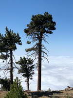
Pines on Hawkins Ridge that survived the 2002 Curve Fire
Winding down the use trail from Sadie Hawkins, I rejoined the main Hawkins Ridge Trail and followed it down to the saddle between Sadie Hawkins and South Mt. Hawkins. Two weeks ago, I’d followed the road up to South Hawkins and then descended the north ridge directly. This time I ascended the Hawkins Ridge Trail, carefully following the trail. I was surprised to find it didn’t ascend the north ridge directly, but wrapped around the west side of the peak.
Later, as I ran down South Mt. Hawkins Trail/Road, I thought about the amount of rocky debris along and on the road. It emphasized the friable nature of the rock above, and how often there are larger rockslides. When I reached the point on the road where I could see the route I’d climbed, I just shook my head. Who the heck would want to go up there?