Once again Southern California is facing another very dry rain year. Since July 1, Downtown Los Angeles (USC) has recorded only 1.97 inches of rain. This is more than 8.5 inches below normal.
At this point it appears likely the rainfall recorded at Los Angeles from July 1 – February 28 will be the second driest for that period on record. If we don’t see some significant rain in March, we could be contending with 2006-2007 for the driest rain year on record.
Several weather models have been advertising a change to a wetter weather pattern for the West Coast and Southern California. At one point the ECMWF was forecasting several inches of rain in the Los Angeles area around March 1-2. This morning’s ECMWF run was far more stingy with the wet stuff, and precipitation completely disappeared from the GFS forecast for that period.
Never fear, these forecasts will likely change again. Model skill more than a few days out is very poor. Next week we should have a better idea if the pattern change is real, or just more model hype.
Update March 1, 2018. With only 1.99 inch of rain from July 1 to February 28, Downtown Los Angeles (USC) did end February with the second driest rain year to date. Depending on whether 1911-1912 is included in the ranking, the water year to-date, beginning October 1, is either the second or third most dry on record. Now all eyes turn to the storm that is forecast to move into the Los Angeles area this evening. This morning the CNRFC 72 hr. QPF for the Los Angeles area ranges from around 0.75 – 1.0 inch in the basin and valleys to around 1.5 – 1.75 inches in the mountains. Higher totals are forecast in the Ventura and Santa Barbara areas. Check with the NWS Forecast Office Los Angeles for the latest weather forecasts, advisories and warnings.
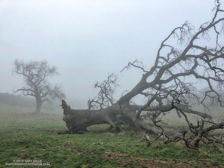
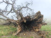
The fallen oak pictured above — one of the larger valley oaks along Rocky Peak fire road — toppled over in the summer of 2016 following five years of drought. Fire and drought are a natural part of the valley oak’s habitat and the trees have evolved to withstand ordinary variations in their environment. However, severe fires or extended droughts, or fire in combination with drought can overcome the tree’s defenses. The drought may have been the culminating factor in the felling of this oak, but fire and other factors may have also played a role.
Base of large valley oak that toppled following five years of drought. Click for larger image.
According to the Fire Effects Information System (FEIS), the heart-rot fungus Armillaria mellea is usually present in valley oaks and larger oaks tend to be hollow or rotten in the center. The toppled oak was hollow near its base and its interior appears to have been blackened by fire. The FEIS describes instances where the decaying wood in the interior of older valley oaks could ignite in a fire, but leave the exterior bark uncharred.
What fire might have burned the tree? There are two possibilities: the 2008 Sesnon Fire and the 2003 Simi Fire. It probably wasn’t the Sesnon Fire — this photo of the tree, taken about a month after the Sesnon fire, shows little impact. I couldn’t find a photo of the tree following the Simi Fire, but photos taken nearby show a severely burned landscape. Ultimately, it appears fire and drought weakened the tree, accelerating its heart rot and weakening its roots to the point it could no longer support itself.
Photos of the fallen oak are from this morning’s foggy run along Rocky Peak fire road.
Assuming Downtown Los Angeles (USC) doesn’t get more than 0.02 inch of rain before the end of the year, the first 6 months of the 2017-18 Rain Year will be the second driest since recordkeeping began in July 1877. Los Angeles has recorded a paltry 0.19 inch of rain since July 1. Only 1962 recorded less rainfall over the six month period. November and December have been particularly dry, with only 0.01 inch being recorded at Los Angeles during each of these months.
What has happened in the past when there has been such a slow start to the July 1 – June 30 Rain Year?
If we look at the 10 driest July-Decembers in Los Angeles, the average Rain Year rainfall for those years is only 9.4 inches, or about 63% of normal. And in all 10 years, the Rain Year rainfall turned out to be below normal. Even if we take the 20 driest July-Decembers the Rain Year average rainfall is about the same — 9.6 inches — and only 2 of the 20 years had above average rainfall.
So, historically, when the first six months of the Rain Year have been very dry, the amount of rain for the entire Rain Year has almost always been below average. We’ll see if that’s the case this time!
The groundwater in upper Las Virgenes Canyon appears to have been replenished by the above normal rainfall last rain season.
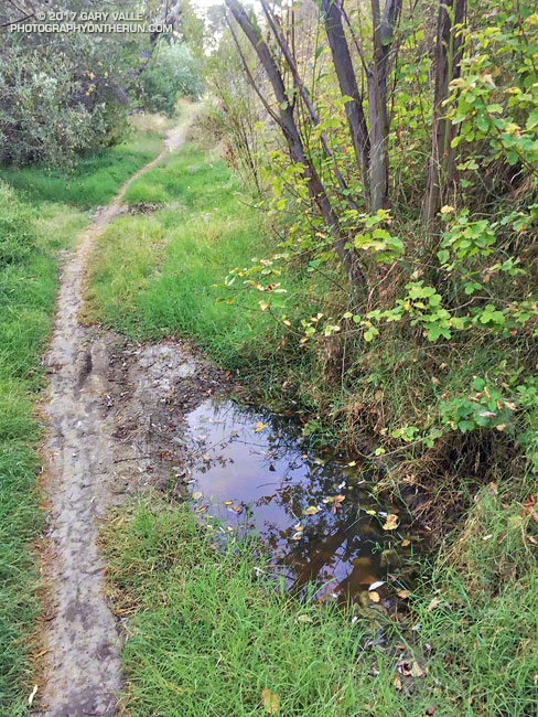
The little spring pictured above has persisted through the dry season and farther up the canyon a tiny stream has trickled defiantly through the Summer. The mainstem creek in upper Las Virgenes Canyon isn’t flowing as it was during the Winter, but the sand at the crossing near the Cheeseboro connector trail remains damp.
It shouldn’t take a huge amount of rain to get the creek flowing again. We’ll see!
Climbing up the slope and around the big incense cedar I stopped for a moment to enjoy the smell of the splintered wood. There had been so many trees across the trail I’d lost count. This was in the neighborhood of the 35th tree I’d had to work around on my way to Mt. Waterman.
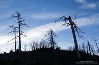
Trees burned in the 2009 Station Fire
My run on the Mt. Waterman & Twin Peaks Trail had started at Three Points. Initially, I’d been encouraged to see some trees had been cut and removed from the trail. But the area was hard hit by the 2009 Station Fire and the combination of fire, years of drought, and rough winter weather seemed to be felling an increasing number of trees each year.
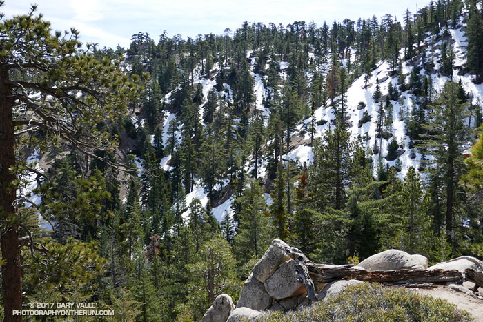
Across the canyon the north face of Twin Peaks was still blanketed in snow. On this warm, south-facing slope the snow was almost gone, exposing a veneer of pine needles, last Summer’s gray and wilted ferns, and the Winter excavations of industrious moles. In every gulch and gully water spilled down the mountainside; splashing, bubbling and burbling downslope under gravity’s spell.
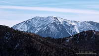
Mt. Baldy from the Mt. Waterman Trail
This was supposed to be a recovery run, following last Saturday’s abridged — but arduous — run on the Backbone Trail. (Many thanks to Howard & Mike and all the volunteers!) The plan was to just go to the summit of Waterman and then back down the same way. But… the idea of crawling over, through or around more than 40 trees a second time just didn’t sound that appealing.
When I reached the junction with Mt. Waterman’s summit trail it took about a millisecond to make the decision to continue on the loop. It would be longer, and would have more elevation gain, but it was a beautiful day and my legs felt OK. Who knew when there would be another opportunity to do the loop in these conditions?
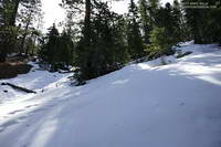
Snow along the Mt. Waterman Trail
Much of the trail down to Buckhorn was covered with snow. Not so much snow as to be a problem, but enough to be interesting and scenic. The weather was great and snow conditions excellent. Following the tracks of hikers, my socks didn’t even get wet!
Reaching Angeles Crest Highway, I ran east a short distance to the entrance of Buckhorn Campground. The gate was locked and the campground still closed for the Winter. Patches of snow, deadfall and other debris littered the area. When the camp is open, I top off my water here. Today the faucets were dry, but with the cool weather that would not be an issue.
Most of the hikers on the Burkhart Trail were going to see Cooper Canyon Falls. Seeing the falls was one of the reasons I’d decided to continue on the loop. My thoughts drifted back to April 1995 when Gary Gunder and I carried our kayaks down this trail and paddled Little Rock Creek from Cooper Canyon to the South Fork. (We put-in below the falls.)
The flow over the falls was the most I’d seen in several years and was probably nearing its peak. After enjoying the falls for a few minutes I scrambled out of the gorge and headed up the PCT. Like all that visit the falls, I now had to climb out of Cooper Canyon.
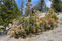
Drought-stressed young pine in Cooper Canyon
The effects of a prolonged drought don’t just disappear overnight, no matter how much it rains or snows. This was particularly evident on the sun-baked segment of the PCT above Cooper Canyon Camp. Just above the camp a large, green-needled Jeffry Pine had collapsed, leaving a large crater where its roots had been. In the year since I’d been on the trail, trees on the warmest, south-facing slopes had become more drought-stressed. It seemed additional trees had died and more had yellowing and brown needles.
Cooper Canyon can be hot, but today the temperature was pleasant. Eventually I reached Cloudburst Summit and clambered over a final steep patch of snow to reach the saddle. Three Points was now just a few miles away. I crossed Hwy 2 and started running down the trail.
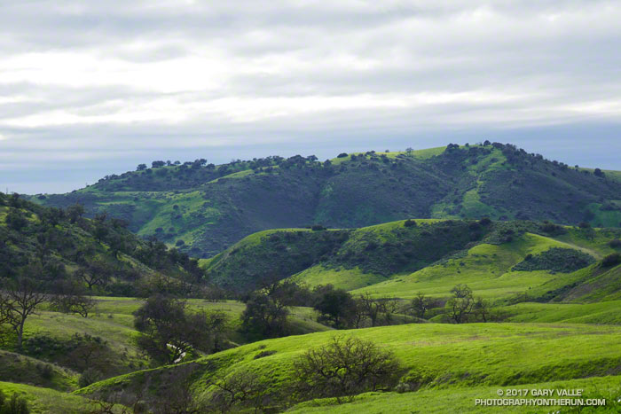
Green is what you get when so much rain falls on a valley oak savanna. This is a view west, down East Las Virgenes Creek, toward Las Virgenes Canyon. The ridge in the distance is between Las Virgenes and Cheeseboro Canyons.