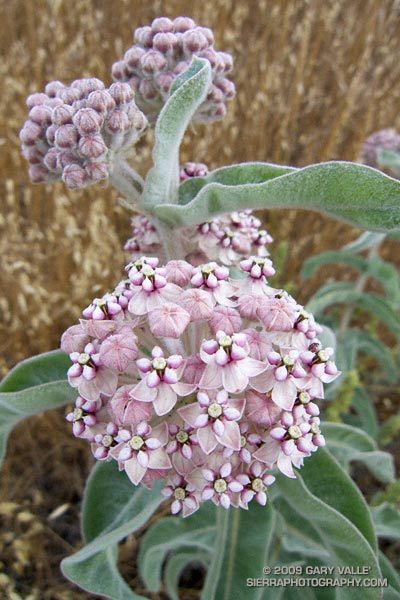
Kotolo milkweed (Asclepias eriocarpa) on Lasky Mesa.
From a run last week in Upper Las Virgenes Canyon Open Space Preserve (formerly Ahmanson Ranch).
Some related posts: Bumblebee, Milkweed Bug Nymphs, Blue Milkweed Beetle, Tarantula Hawk

Kotolo milkweed (Asclepias eriocarpa) on Lasky Mesa.
From a run last week in Upper Las Virgenes Canyon Open Space Preserve (formerly Ahmanson Ranch).
Some related posts: Bumblebee, Milkweed Bug Nymphs, Blue Milkweed Beetle, Tarantula Hawk
There is nothing quite so compelling as an unanswered question.
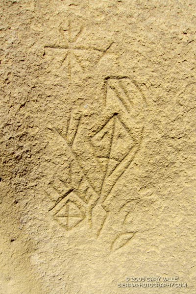
Several years ago, in the middle of a trail run, an unusually shaped rock formation caught my eye. After a little bushwhacking and exploration, I found a way to climb the formation, and on its summit found a small pictograph. I wondered if there might be other pictographs in the area, and on the way back to the trail found the inscription pictured above.
Later, I took a friend with more ethnographic experience to the top of the rock, and it was his opinion that the pictograph, as well as the nearby inscription, were not of modern origin. He also mentioned that the rock likely marked the point on the southeastern horizon where the sun rises on the Winter Solstice, as seen from a Chumash shrine several miles away.
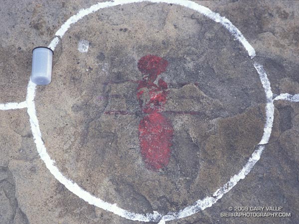
The pictograph on the solstice rock appears to have been painted using an ochre pigment, which may have been mixed in an adjacent cupule. It is in a harsh environment, fully exposed to the sun, wind and rain. It’s my guess that the white “alignment” reticule surrounding the pictograph is an unfortunate recent addition.
The petroglyph is in a concavity on the north side of a large boulder, and is better protected. That the drawing appears to be astronomical in nature, and is adjacent to a rock possibly used to mark the Winter solstice is probably not a coincidence.
To speculate on the purpose and meaning of such a drawing is to travel in time, and through the thoughts and eyes of another, visit a world far different than our own.
In this case that someone was probably an ‘alchuklash — an astronomer-priest-shaman who was a part of a religious-spiritual cult known as the ‘antap — a pervasive power elite within Chumash society.
The ‘alchuklash were adept astronomers, not only observing the Winter and Summer Solstices, but the moon, individual stars, asterisms, constellations, planets, Milky Way, eclipses and more. The observation and interpretation of the Upper World were an integral part of the Chumash cultural and world view.
But the Upper World did not exist on its own. The Chumash appreciated and celebrated the interdependency of Nature, and events in the Upper and Lower Worlds were inexorably tied to those in the Middle World of everyday existence. Using their specialized knowledge, the ‘antap facilitated communication and interaction between these worlds to the benefit, or peril, of the People.
It is in this context that in the drawing I see the powerful personage of an ‘alchuklash, who has reached into the Upper World. Perhaps the drawing is a commemoration of the power of the place. Perhaps it is a kind of owner’s manual, a premodern PDF, illustrating the purpose of the solstice rock. Or, perhaps it is something we cannot know.
Note: The contrast of the lines in the image has been increased to make them easier to see. In the ten years since I first photographed the etching, some detail has been lost in the lower right corner of the drawing. This image is from April 21, 2009.
Reference: Crystals in the Sky: An Intellectual Odyssey Involving Chumash Astronomy, Cosmology, and Rock Art. Travis Hudson and Ernest Underhay (Foreword by Anthony F. Aveni and illustrated by Campbell Grant). Socorro, New Mexico: Ballena Press Anthropological Papers No. 10, 1978, 163 pp.
Google search: $g(Chumash), $g(petroglyph), $g(pictograph), $g(rock art), $g(solstice), $g(astronomy), $g(ethnography), $g(shaman)
Overnight the lows on the high peaks had dipped into the 30’s, and today the high temps would be 15-20 degrees below normal. If I could have ordered the perfect mix of temperature, clouds and sun for running in the Angeles high country, it would be difficult to top the weather this weekend and last.
Now that Hwy 2 was open between Islip Saddle and Vincent Gap, and we could do a car shuttle, Miklos, Krisztina and I had decided to run from Inspiration Point to Islip Saddle on the PCT. Starting at Inspiration Point instead of Vincent Gap adds about 4.5 miles to the run, but the miles are relatively easy, and the stretch is a good warmup for the 2800 ft. climb up Mt. Baden-Powell.
Here’s a Cesium browser View of a GPS trace of our approximately 18 mile route. We wandered down the south ridge of Mt. Baden-Powell, so this is a little longer than the usual route. The elevation gain was about 3300 ft., with an elevation loss of about 4000 ft. Continuing over Mt. Williamson to Eagle’s Roost would add about 4 miles and 1400 ft. of elevation gain.
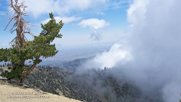
Note: The speck in the summit photo is one of several violet-green swallows working lift and zooming along the top of southeast face.
From Sunday’s hike/run up and down Mt. Baldy’s South Ridge.
Like many runners, I like to do a recovery run the day after a race, or strenuous run. Combined with some stretching before and after, an easy-paced run helps to work the bugs and stiffness out of the body and mind.
It may have been only 14 miles long on the map, but from my legs point of view, yesterday’s hike/run up and down Mt. Baldy’s South Ridge felt more like about twenty normally hilly miles.
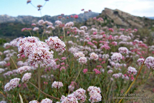
The photo above is California Buckwheat (Eriogonum fasciculatum var. foliolosum), at Sage Ranch Park.
One, two, ten…
Will the switchbacks ever end?
I can’t think of a tougher stretch of trail in the San Gabriel Mountains. From Mt. Baldy Village, the Bear Canyon/Old Mt. Baldy Trail climbs 5800′ in 6.7 miles to the 10,064′ summit of Mt. Baldy (Mt. San Antonio). The route is as rewarding as it is difficult, with inspiring views and interesting terrain.
I had hoped for some remnant clouds from Friday’s storms, but didn’t expect to be using my windshield wipers driving to the trailhead. The dark gray clouds piled against the mountains had a scuddy, stormy look, and I had a difficult time convincing myself that it was just a deep marine layer. But the sun was shining when I parked at the bottom of Bear Canyon Rd. and began to walk up the steep, cabin-lined street.
The last time I had been on the trail was July 2004, during the Baldy Peaks 50K. That day we started at the parking lot at Icehouse Canyon, and over the course of the race climbed Mt. Baldy twice. The first time from the Village, and the second time from Manker Flats. Today I wasn’t in a race, and would be completely satisfied to climb Mt. Baldy just once.
Running up a moderate section of trail below Bear Flat, I tried to figure out the last time I had run down the Bear Canyon Trail. Sometime before the Baldy Peaks race. I wasn’t sure how long it had been, but long enough to forget how grueling steep downhill can be.
My thoughts are interrupted by a pair of hikers coming down the trail. I ask how they’re doing, and am surprised to hear, “not so good.” They look disappointed and tired, and anxious to get down to the car. I wonder if one of them is ill, or if they just underestimated the difficulty of the trail.
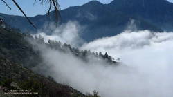
A half-mile later I’m crossing the creek at Bear Flat (~5500′). This is where the fun begins. Here the trail switchbacks up a steep east-southeast facing chaparral slope to Mt. Baldy’s South Ridge, gaining about 1500′ in one mile. On a warm day it can be hellish. On a cool day it isn’t easy. Today it is cool. The cloud layer has continued to crawl up the mountain, and it envelops me as I start up the switchbacks.
A little more than a year ago, these slopes were burned in the 2008 Bighorn Fire. I had expected to see black, burned and barren chaparral in the initial stage of recovery, but instead there is substantial growth, comparable to 2-3 years of recovery in chaparral at a lower elevation.
At an elevation of about 7000′, I climb out of the clouds and into the sun. What a day! Benign clouds lap at the mountainside, enhancing already dramatic views. Between 7000′ and 9000′, I encounter several hikers and briefly chat with one veteran hiker, who tells me this is his friend’s intro to hiking! It is a busy day for this trail, and I’m guessing I’ll see more hikers when I descend.
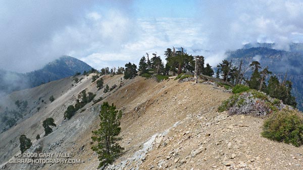
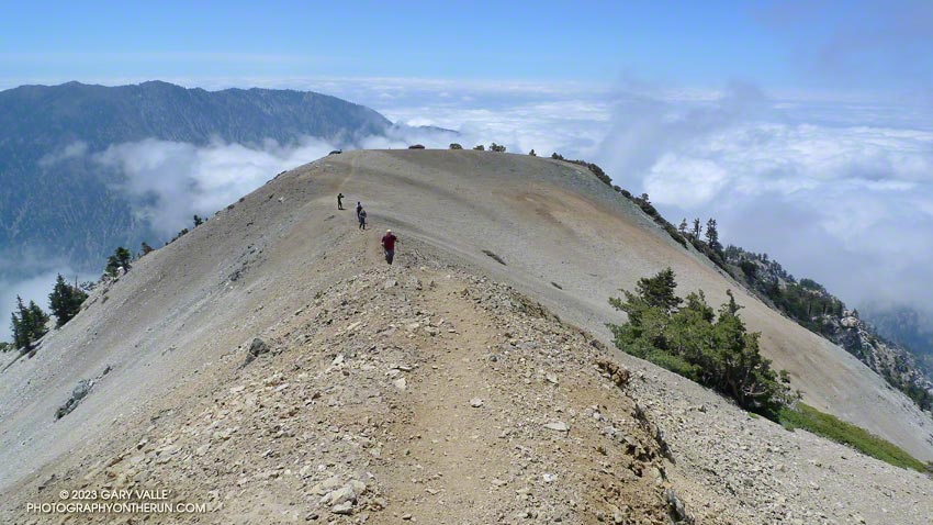
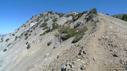
Above 9000′ the open forest of Jeffrey, Sugar and Lodgepole pine becomes more sparse and stunted. The route feels more alpine and climbs onto the rocky crest of an exposed ridge (HD Video Snapshot). A little higher, a large patch of snow accentuates the “you’re getting near tree line” feeling.
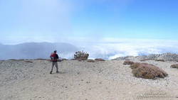
Approaching Baldy’s summit, I’m surprised to see a wispy cloud had also ascended the peak and is waiting for me to catch up. On top there seems to be a mix of young and old, veterans and first-timers, excitement and exhaustion. After a few minutes on the summit, I run over to West Baldy. Then it is gravity’s turn, and I take the first steps down the slope.
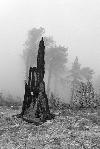
The descent is just as extraordinary as the ascent, with far-reaching mountain views over a sea of clouds. On an exposed section of the ridge at about the 8500′ I happen on a Sugar pine with a spiral scar from a lightning strike. Such trees are disturbingly common. There is a Jeffrey pine at about the same elevation on Mt. Baldy’s North Backbone Trail with a similar lightning scar.
At around 7500′, I descend into the clouds. The change from blue to gray does not carry with it the usual malaise. Wisps of warm cloud thread softly through the pines and a solitary deer walks silently through the dream-like scene (Video snapshot).
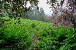
One, two, ten… Will the switchbacks ever end? Finally, through the trees I see the brilliant green of the ferns at Bear Flat. Running becomes easier. I pick up the pace, and in a few minutes turn onto the asphalt of Bear Canyon road.
Here is an interactive, 3D terrain view of a GPS trace of my route on the Mt. Baldy’s South Ridge on the Bear Canyon/Old Mt. Baldy Trail. The map can be zoomed, tilted, rotated, and panned using the navigation control on the right. Track and placename locations are approximate and subject to errors. Snow, ice, poor weather, and other conditions may make this route unsuitable for this activity.
Some related posts: Mt. Baldy Runner, Lightning Tree