Category Archives: nature

Mt. Hawkins Lightning Tree

An unusual, offset lightning scar on a Jeffrey pine in the San Gabriel Mountains, near Los Angeles.

An unusual, offset lightning scar on a Jeffrey pine in the San Gabriel Mountains, near Los Angeles. The tree is located at an elevation of about 8750′, on the ridge east of Mt. Hawkins.

The offset scar is not easily explained. Either the scar was offset when created, became offset as the tree aged, or perhaps multiple strikes have somehow created the appearance of an offset. None of these explanations seem completely satisfactory.

The lightning scar on the Mt. Hawkins tree appears to be older than the scar on the Jeffrey pine on the Three Points – Twin Peaks Saddle trail, and quite a bit older than the scar on the Jeffrey pine on Mt. Baldy’s North Backbone Trail.

Google search: $g(lightning)

Hexagonal Close Packing

Hexagonal close packing of the disk florets of an immature Sneezeweed blossom.

There are some imperfections, but generally the unopened disk florets comprising the head of this immature sneezeweed blossom are arranged so that each floret is surrounded by six other florets. This is an example of hexagonal close packing, and is probably the most dense arrangement of florets that can be achieved in this spherical flower head.

The photograph of the Bigelow’s sneezeweed (Helenium bigelovii) was taken on an out and back run on the Pacific Crest Trail from Vincent Gap to Little Jimmy Spring during July 2007.

Related post: Bigelow’s Sneezeweed & Bee

Did Lightning Start the 2002 Curve Fire?

Or did the Curve Fire trigger a lightning strike?

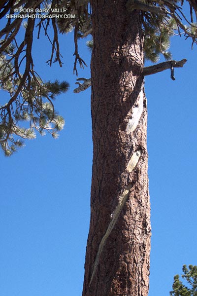
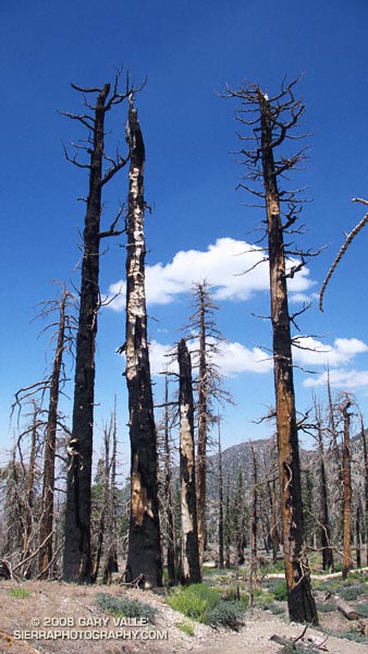
These trees — on a section of the Pacific Crest Trail east of Windy Gap — were burned almost six years ago in the 20,857 acre Curve Fire. According to the Curve Fire Burned Area Emergency Report Implementation Plan, the source of ignition for the devastating fire was “a ritual involving the use of fire (candles) and animal sacrifices.” The fire started the afternoon of September 1, 2002.

However, in the document An Exercise Involving Flash Flood and Lightning Potential Forecasts, an alternative ignition source was suggested — an “out of the blue” lightning strike. Forecasters observed a “single positive lightning strike northeast of the Mount Wilson Observatory” about 1:00 PM PDT (2000Z), near the time the Curve Fire started. According to NWS Lightning Safety Outdoors, such bolts from the blue have been documented to travel more than 25 miles from a thunderstorm cloud.

While there is compelling evidence that the blue sky lightning strike occurred, the time of the strike suggests that it was not the initial source of ignition of the Curve Fire. This UCLA Solar Towercam image is time-stamped at 12:58:58, about the time of the strike. It shows the Curve Fire already underway, with a well-developed smoke column. The photograph also shows the cloud development over the San Gabriel Mountains.

An intriguing question comes to mind. Was the lightning strike a coincidence, or was it somehow triggered by the fire, or the smoke?

According to “Forest Fires: Behavior and Ecological Effects” by Edward A. Johnson, Kiyoko Miyanishi (Academic Press, 2001) large scale lightning detection networks have revealed an association between forest fires and the electrification of thunderstorms. Further, “a shift from negative to positive ground flash prevalence in association with fires and forest fire smoke” has been documented.

So it looks like lightning did not start the Curve Fire, but the Curve Fire may have triggered the positive lightning strike observed by the NWS!

The photograph of trees burned in the Curve Fire is from Sunday’s Islip Saddle – Mt. Baden-Powell South Fork run.

Related post: Explosive Growth of the Lake Fire

Technical papers:

CLOUD-TO-GROUND LIGHTNING DOWNWIND OF THE 2002 HAYMAN FOREST FIRE IN COLORADO

Timothy J. Lang* and Steven A. Rutledge
Colorado State University, Fort Collins, Colorado

Enhanced Positive Cloud-to-Ground Lightning in Thunderstorms Ingesting Smoke from Fires

Walter A. Lyons, Thomas E. Nelson, Earle R. Williams, John A. Cramer, and Tommy R. Turner
Science 2 October 1998 282: 77-80 [DOI: 10.1126/science.282.5386.77] (in Reports)

Islip Saddle – Mt. Baden-Powell South Fork Loop

View of the South Fork Big Rock Creek and Devil's Punchbowl from Mt. Baden-Powell.

Maybe it’s because it’s been in the news recently,  but when pondering how to characterize today’s trail run, I couldn’t help but think of the JFK quote, “We do these things not because they are easy but because they are hard…” This loop is arduous, adventurous, and challenging. While the difficulty of this route is one of the things that makes it interesting, it isn’t just the difficulty that makes it appealing.

Part of the appeal is the mix of trails and terrain, and the contrasting environments. The high point of the route is 9,399′ Mt. Baden-Powell. Cool, airy and alpine, it is the home of ancient Lodgepole and Limber pines. The low point of the route is 4,560′ South Fork Campground. On the margin of the Mojave Desert, it is often hot and sometimes torrid. Midday temperatures here can reach well over 100°F. The route encompasses life zones ranging from the Upper Sonoran to the Hudsonian, and passes through a variety of plant communities. The San Andreas Fault Zone runs along the base of the mountains, torturing the area’s rocks, and producing a complex and fascinating geology.


Erosion gulley on the Manzanita Trail.
From Islip Saddle the route descends the South Fork trail to South Fork Campground, then climbs 5000′ on the Manzanita and Pacific Crest trails to the summit of Mt. Baden-Powell. From here it follows the PCT back to Islip Saddle. In general, the part of the route that is on the PCT — above Hwy 2 — is well marked and maintained. However, on the South Fork and Manzanita trails — below Hwy 2 — you are on your own.

There are rock slides on the South Fork trail, and there are steep, washed out erosion gullies on the Manzanita trail. Recent thunderstorms have further damaged the eroded sections of the Manzanita Trail. In addition, the Manzanita trail crosses boulder-strewn washes that can make the trail difficult to follow. It is not a trail I would want to be on when there is heavy rainfall. The South Fork and Manzanita trails are part of the High Desert National Recreation Trail.

Google Earth images and KMZ files, and more info about the loop can be found in the posts Complications, Wally Waldron Limber Pine, and Heat Wave.