Category Archives: trees

Hard Winter

Broken lodgepole pine near Throop Peak

The out and back to Mt. Baden-Powell from Islip Saddle has become a springtime running ritual for me. Sometime in April, May or June, I like to get back to the high country, and see what there is to see — including whether there’s any snow left on Baden-Powell or Mt. Baldy.

Satellite imagery of snow along the crest of the San Gabriel Mountains, April 28, 2020.
Snow in the San Gabriel Mountains, April 28, 2020. Click for larger image.

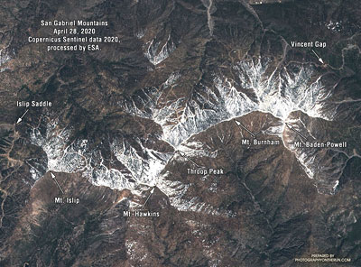
Sentinel satellite imagery showed a lot of snow along the crest at the end of April, but hot weather and dry winds in May accelerated the melt. By early June most of it was gone. It didn’t seem likely I would see any today.

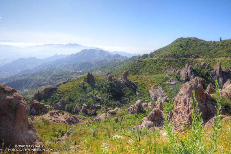
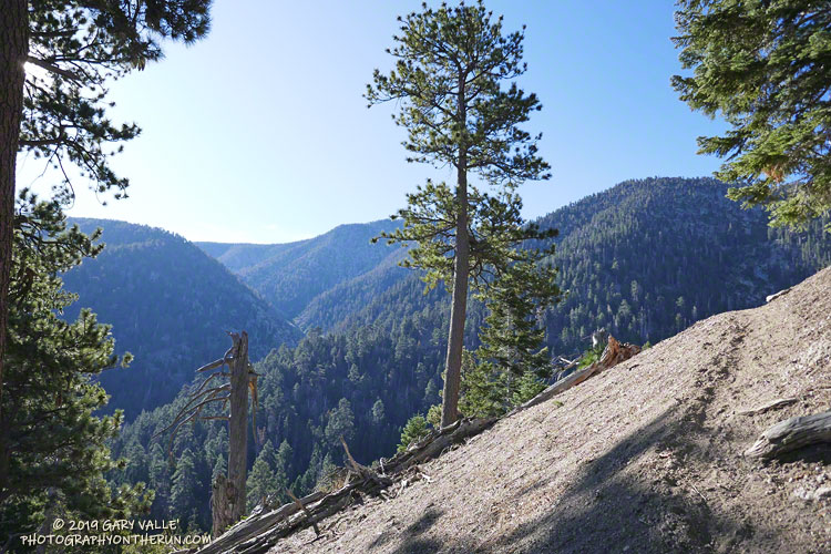
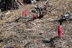
I hadn’t seen any snow along the trail this morning. I’d run past Little Jimmy Camp, Windy Gap, Peak 8426, and was now at an elevation of about 8700′, near Mt. Hawkins. Above me, I could hear the excited voices of a couple of hikers near its summit. Thinking they might be part of a group, I looked up the trail toward the crest.

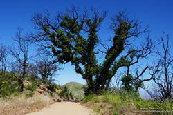
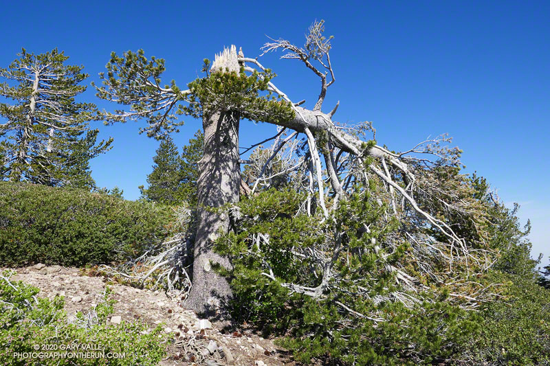
Something was missing… Where was it? Usually prominent on the skyline at this point, the “Mt. Hawkins Lightning Tree” was gone. I walked up the trail to look for the familiar landmark. The trunk of the lightning-scarred Jeffrey pine had been snapped like a twig. The crown of the tree lay 50 yards down the steep slope, jammed against two trees.

Jeffrey pine near Mt. Burnham, toppled by Winter winds.

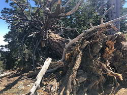
It must have been a hard Winter. Several other live trees along the crest between Mt. Hawkins and Mt. Baden-Powell were either blown down or broken in half. In some cases, the damaging winds appeared to be from the south side of the crest and in others from the north. December 2019 was stormy in Southern California, particularly around Christmas. Weather data suggests this might have been when most of the damage was done.

Today, only two large trees blocked the trail. One, on the west side of Mt. Burnham, was easy to go under or around, but the other, west of Throop Peak, was a bit more of a challenge. Given the brush on either side, climbing over the tree worked for me. Some others had detoured well above or below the tree.

Snow plant along the PCT near Throop Peak.

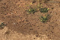
Surprise, surprise! It turned out there were a couple of small patches of snow on the north side of the crest near Baden-Powell. These were the remnants of an area of wind-deposited snow on the lee (north) side of the crest between Mt. Baden-Powell and Mt. Burnham. Large drifts can collect here, and in a heavy snow year, can persist into July. The deposition area can be seen in the Sentinel satellite image.

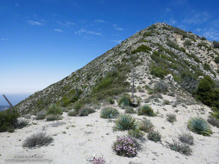
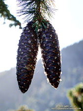
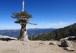
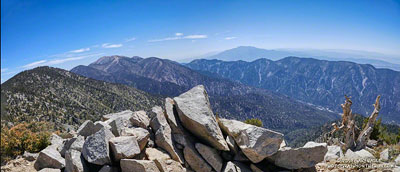
With its long views, sub-alpine elevation, and weather-worn limber and lodgepole pines, Baden-Powell is a rewarding summit. Just a few miles to the southeast, Mt. Baldy looms above a mile-deep canyon. If the visibility is good, San Jacinto Peak and San Gorgonio Mountain can be seen beyond Mt. Baldy, many miles in the distance.

The distance from Islip Saddle to Mt. Baden-Powell (9,399′), and back, is about 16 miles. The cumulative elevation gain is about 3800′. Here’s an interactive, 3D view of the out and back route.

Trail note: I ran into a “misplaced” hiker that didn’t know what trail they were on or where they started. Take the time to familiarize yourself with the adventure you have planned!

Some related posts: Mt. Hawkins Lightning Tree (2008), No Worries About Snow Flurries (2019), Mid January Trail Run from Islip Saddle to Mt. Baden-Powell (2014), Snowless San Gabriels (2007)

Trees, Bees, and a Washed-Out Footbridge on the Bulldog Loop in Malibu Creek State Park

Looking along the crest of the Santa Monica Mountains from near the top of the Bulldog fire road.
View east of the Santa Monica Mountains from near the top of the Bulldog fire road.

With the reopening of trails in the Santa Monica Mountains, my list of “must do” trails is impossibly long. Today, I headed over to Malibu Creek State Park to do a variation of the popular Bulldog Loop, and catch-up on what was happening in the Park as it recovers from the Woolsey Fire.

The route I was running starts at the Cistern Trail trailhead on Mulholland and descends to Crags Road using the Lookout and Cage Creek Trails. After a side trip on the Forest Trail to see the coast redwoods, it continues counterclockwise around the regular Bulldog Loop. Here’s an interactive, 3D view of the approximately 17-mile variation of the Bulldog Loop.

Crossing Malibu Creek

Summer 2022 Update. A seasonal bridge has been installed across Malibu Creek at the site of the original bridge. The bridge is removed when there is a threat of flooding on Malibu Creek. This is typically during the rainy season.

As I ran along Crags Road toward the M*A*S*H site, I wondered how much water would be in Malibu Creek, and if the fallen tree used to cross the creek would still be there.

Washed-out footbridge on Malibu Creek

Since February 2019, hikers, runners, and riders doing the Bulldog Loop or headed to the M*A*S*H site have had to either get their feet wet or use a fallen tree to cross Malibu Creek. The concrete slab bridge is still there, but the stream now flows around the bridge, rendering it useless.

The bridge survived a canyon-wide flood in mid-February 2017. But two years later, and just 11 weeks after the Woolsey Fire, sediment-laden runoff from burned hillsides clogged the drainage pipes embedded in the bridge’s concrete slab. With nowhere to go, the stream simply circumvented the structure.

Nearly to the bridge, I turned right off of Crags Road and followed the well-trodden path along the creek for about 70 yards. The downed tree had not washed away. Not wanting to take an early morning bath, I carefully worked across the logs and limbs and then rejoined the Crags Road Trail, near a coast redwood.

Checking on the Malibu Creek State Park Redwoods

Whenever I do the Bulldog Loop, I usually stop by the Forest Trail and see how the 100+ year-old coast redwoods are doing. Several of the 16 or so redwoods were killed by the 2011-2015 drought, and virtually all the trees were scorched in the Woolsey fire.

New growth on a young redwood in Malibu Creek State Park
New growth on a young redwood burned in the Woolsey Fire

I’d last checked on the redwoods at Christmas and had been encouraged by the condition of the remaining trees. In Los Angeles, three of the past four rain years have recorded average or above-average rainfall. This seems to have really helped the surviving redwoods.

There are five or six trees that are doing well. They’ve added a lot of new foliage and look healthy. I was excited to see that a young, naturally-germinated redwood was thriving. It was burned in the Woolsey Fire and lost most of its foliage.

Leaving the redwoods behind, I continued toward the M*A*S*H site and then up the Bulldog climb.

Coast Live Oak Recovery

Live oaks are amazingly resilient. Oaks, more or less as we know them, have been around for millions of years. According to Cal Poly’s PolyLand web site, 25 myr-old fossils of coast live oak have been found in the Pacific Northwest. This suggests an exceptionally adaptable species.

Epicormic sprouting of a coast live oak burned in the Woolsey Fire
Recovering coast live oak

As I worked up the Bulldog fire road, I marveled at the number of live oaks sprouting new foliage on their burned trunks and limbs. On Mesa Peak Mtwy fire road, there is a grove of live oaks that used to provide welcome relief from the blazing-hot summer sun. On the crest of a ridge, the trees must have been fully-engulfed in fire when burned during Woolsey Fire. None the less, the trees are recovering. Compare this December 2018 photo of one of the larger live oaks, to what it looks like today. Incredible!

Digger Bees

Cruising along Mesa Peak Mtwy fire road, I took an auditory double-take. What the heck was all the buzzing around me? That’s when I realized the loud, resonate buzz was from thousands and thousands of bees. I’d just run into a huge aggregation of digger bees.

Digger bees in Malibu Creek State Park
Digger bees along Mesa Peak Mtwy fire road

I’ve encountered them before. Even though the males (reportedly) don’t have a stinger and the females (reportedly) aren’t usually aggressive, it was a little unnerving walking through so many active bees. Here’s a video snapshot of the digger bees on Mesa Peak fire road.

Digger bees are not social in the same way as honeybees. Female digger bees build their individual brood cells in a communal area to efficiently reproduce. According to behavioral ecologist John Alcock, the males emerge slightly before the females and then fly low over the area, searching for females that are about to emerge. Using their antennae, the males can find the females in a burrow, before they emerge, gaining a competitive edge. For more info, see the article Desert Diggers, in Arizona State University School of Life Sciences’ Ask A Biologist web site.

Splendid Mariposa and Other Wildflowers
Splendid mariposa lily in Malibu Creek State Park
Splendid mariposa lily

At first I ran past it. I was descending the Tapia Spur Trail and nearly to the gravel parking lot in Malibu Creek State Park when a flash of purple caught my eye. My thought was that it was a solitary farewell-to-spring (Clarkia). But something didn’t seem right, and it would be unusual to see just one farewell-to-spring. So I went back to take a look, and it turned out to be a splendid mariposa lily (Calochortus splendens). Although it is common in areas south of Los Angeles, it is the first I have photographed in the Santa Monica Mountains. This one was not quite so splendid as it might have been since a beetle had been feasting on its petals.

Here are a few other flowers seen along the way:

Filaments of spider silk on Indian pink (Silene laciniata)
Indian pink

Indian Pink (Silene laciniata)

Wild morning glory (Calystegia macrostegia)

Canyon Sunflower (Venegasia carpesioides)

Bleeding heart (Ehrendorferia ochroleuca)

Large-flowered phacelia (Phacelia grandiflora)

Some related posts: After the Woolsey Fire: Bulldog Loop, After the Woolsey Fire: Malibu Creek State Park March 2019, Malibu Creek Flooding, Malibu Creek State Park Redwoods: Fighting the Drought

Condor Peak Out and Back Adventure Run

East Ridge of Condor Peak

“Condor Peak-Elevation 5430 ft. – 1 Day
By Vogel Canyon Trail.
Drive Big Tujunga Canyon road to Vogel Flat
Ranger Station and park auto. Hike trail starting
opposite station for short distance up Vogel Canyon,
then around mountain slope west of Big Tujunga
Dam to summit of Condor Peak. Return by
same route. Carry water and cold lunch. No fires
permitted. Total hiking distance, 12 miles.”

— Trails Magazine, VOL 1 NO. 4, Trail Trips, Autumn 1934

The relocation of Big Tujunga Canyon Road in the 1950s shifted the starting point, and some other details have been updated, but the route from Vogel Flat to Condor Peak is pretty much the same as it was in 1934.

It’s telling that hikers of that era would have estimated the round-trip distance to Condor Peak at 12 miles. This was probably a “feels like” estimate of distance, based on time. The mileage in the description is far less than the presently accepted distance of 15.5-16.0 miles. Back then, the trail would have been relatively new and in better condition than it is now. Even so, they must have been fit and fast!

The “Vogel Flat” trailhead for the Condor Peak Trail is now a little to the east and above its original location, and is not obvious. If traveling up-canyon on Big Tujunga Canyon Road, it is just past Vogel Flat Road, directly across the highway from the second turnout on the right.

Note: Even in the best of circumstances, hiking, running, or riding a mountain trail involves risks. The nature of the terrain this trail navigates is such that the risk from falling while running, hiking or riding, crossing washouts, and from heat-related illness is high. There are some sketchy sections with large drop-offs. In particular, below Fox Mountain there was a very exposed washout at the top of a steep sandy chute that required extra care to cross.

As was the case last week on the Stone Canyon Trail, it looked like some sections of the Condor Peak Trail had been trimmed in the last year or two. And like the Stone Canyon Trail, the trailwork ended partway to the peak. In this case, it ended about two-thirds of the way to Condor Peak, as the trail turns northwest and contours around Fox Mountain. The bushwhacking wasn’t nearly as bad as on the Stone Canyon Trail, and things improved once up on Fox Divide.

Prior to this outing, I’d only attempted to do the peak in December and January. There is almost no shade, and the trail traverses several south and south-east facing canyons that act like solar ovens. The last time I did Condor Peak, in December 2007, the overnight low at Clear Creek had been 34 degrees and the high 52. That day was chilly in the shade, but about right in the sun. Today, the overnight low at Clear Creek was 63 degrees and the high 75. It was warm, but with an early morning start, was OK.

It was a relief to finally reach Fox Divide. In 2007 we climbed Fox Mountain from this point. Today I was running alone and thought the ascent of Fox, as short as it is, might result in me running short of water. I didn’t do Fox, and as things worked out, I finished the last of my water about a half-mile from the end of the run. (There is a spring, but the flow was just a trickle.)

I had not reread my notes from 2007 and had conveniently forgotten the nature of the final 1.5 miles between Fox Mountain and Condor Peak. I won’t spoil the adventure here.

There was a fairly well-defined path up the steep, east ridge of Condor Peak. As in 2007, the red register container was on the western summit. The eastern summit, marked by a robust yucca, is about the same height. Viewed from the summit of Condor Peak (5440+’), Mt. Lukens (5074′) was clearly lower in elevation.

Like last Sunday on the Stone Canyon Trail, I did not see anyone on the way up or down the Condor Peak Trail. Ironically, just a couple miles away, there were over a hundred cars parked along Big Tujunga Canyon Road at the Gold Canyon/Trail Canyon access.

Here’s a 3D Cesium interactive view that shows a GPS track of my route up and down the Condor Peak Trail to Condor Peak. The view can be zoomed, tilted, rotated, and panned. Placemark and track locations are approximate and subject to errors.

And here are a few photos taken along the way.

Some related posts: Condor Peak Trail Run, Back to the Stone Canyon Trail

Goldfields Are Blooming and Valley Oaks Greening!

Goldfields blooming on Lasky Mesa, March 7, 2020

Goldfields are tiny wildflowers, but their bright yellow color more than makes up for their diminutive size.

New leaves on a valley oak in East Las Virgenes Canyon. March 11, 2020.
New leaves on a valley oak in East Las Virgenes Canyon.

Goldfields bloomed a little early on Lasky Mesa this year. Depending on the conditions, they usually begin to bloom in mid-February. Because of this rain year’s wet December and dry January-February, the goldfields began to bloom a little early — around February 4. The flowers aren’t as numerous as last year, but there are still a few small patches of goldfields to be seen.

Usually, about the same time goldfields begin to bloom, valley oaks are starting to sprout new, bright green leaves. This Winter, the foliage on valley oaks at Upper Las Virgenes Canyon Open Space Preserve (Ahmanson Ranch) began to turn brown in mid-December and I saw the first new leaves begin to sprout at the end of February. This sprawling valley oak is in East Las Virgenes Canyon.

An Out-of-the-Way Trail, Two Peaks, a Wheelbarrow, and Washington’s Monument

Forsee Creek canyon from the John's Meadow Trail in the San Gorgonio Wilderness.

Wow, what a fantastic trail, canyon, and morning!

The view above is from the John’s Meadow Trail, a circuitous trail that winds its way through a less-traveled part of the San Gorgonio Wilderness.

Sugar pine cones
Sugar pine cones along the John’s Meadow Trail.

The prominent canyon in the photo is home to Forsee Creek. During the last ice age, it held one of San Gorgonio’s small glaciers. I’d just crossed the Forsee Creek a few minutes before, and in a few hours would run past its source high on the crest — Trail Fork Springs.

The peak at the head of the canyon is East San Bernardino Peak (10,691′). Its summit marks the crest of the divide and the location of the San Bernardino Peak Divide Trail. That’s where I was headed, but the path would be anything but direct.

From the Forsee Creek crossing at 7270′, the John’s Meadow Trail climbs about 1000′ in 2.3 miles to join the Divide Trail at “wheelbarrow junction,” about 5 miles west of East San Bernardino Peak. From that point I worked up the popular and scenic Divide Trail, visiting Limber Pine Bench (9330′), Washington Monument (10,290′), and San Bernardino Peak (10,649′) along the way to East San Bernardino Peak.

A weather-beaten lodgepole pine at Limber Pine Bench on the San Bernardino Peak Divide Trail.
Weather-beaten lodgepole pine.

Using this roundabout — but very scenic — route, it took me about the same time to reach San Bernardino Peak from the Forsee Creek Trailhead as it does to do San Gorgonio Mountain from the South Fork Trailhead. From San Bernardino Peak it’s a little less than a mile to East San Bernardino Peak and from there only about 0.75 mile to the lateral to Trail Fork Springs.

From the westernmost Trail Fork Springs junction with the Divide Trail the theme was downhill, downhill, and more downhill — about 3800′ of downhill over 6.7 miles.

The running on the Forsee Creek Trail was generally very good. I was glad I did the loop counterclockwise. The John’s Meadow Trail and its extension are enjoyably primitive — they appear to be “use” trails that have evolved over time. On the other hand, the Forsee Creek Trail is a constructed trail. It was designed as a pack trail, so is generally well-behaved. Great for going down, but a long haul up with a heavy pack!

San Gorgonio Mountain and San Jacinto Peak from East San Bernardino Peak.
San Gorgonio and San Jacinto from East San Bernardino Peak.

Here are a few photos taken along the way, and here is an interactive Cesium ion view of the GPS trace of my route. The 3D view can be zoomed, tilted and panned.

Note: Water is generally more reliable and accessible on the John’s Meadow Trail than on the Forsee Creek Trail. Trail Fork Springs and Jackstraw Springs are seasonal water sources that may not have water. Check with the Mill Creek Ranger Station for the current conditions and more info.

Guardian Oaks

Young valley oaks and coast live oaks at the edge of the canopy of large valley oak in Upper Las Virgenes Canyon Open Space Preserve.

One day while running at Ahmanson Ranch, I was admiring the stately limbs of a large valley oak, and noticed that along the margin of the canopy were several sapling oaks. As I continued my run, I found that only a few other valley oaks hosted a brood of young trees.

That oaks would sprout on the margin of the canopy made sense. There is an abundance of acorns at the ends of the limbs. It is also where water drips from the oak’s leaves on foggy days or when there is light rain or drizzle. The mix of sun and shade on the edge of the canopy is the perfect place for a young oak to thrive.

The surprise came when I took a closer look at the young trees. Most were valley oaks — the same as the shepherding tree — but in some cases the young trees were coast live oaks! And sometimes there was no obvious parent coast live oak nearby.

Of course, there are plenty of coast live oaks at Ahmanson and several ways for their acorns to find their way under a valley oak. Birds and squirrels love to stash acorns, and gravity is good at moving round things downhill.

Time is at a different scale for a tree. In my mind’s eye I accelerated time and watched as the young oaks surrounding a guardian oak grew in stature. Fire sweeps through the frame on several occasions. During one fire the old brood tree collapses and in another fire, the collapsed tree disappears from the frame. Of the young oaks that have survived, one dominates, spreading its limbs and growing large and robust. Along the margins of its canopy, I can see several sapling oaks…

Note: The young oaks in the title photo are an older brood that survived the Woolsey Fire, but many younger sapling oaks were killed. Introduced grasses, black mustard, and other introduced plants produce higher fuel loads than native equivalents and increase fire mortality.