Parked in a turnout on Mulholland Hwy, I finished putting on sunscreen and then pushed the Start/Stop button on my watch to dial in the GPS and pair my HRM. Outside, it was a chilly 43 degrees. Sunrise was nearing and the strengthening March sun was forecast to push temps well into the 70s.
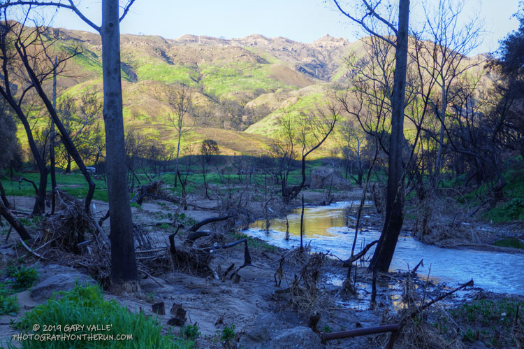
In the aftermath of Woolsey Fire, I’d returned to Malibu Creek State Park to see the wildflowers; gauge the response of the creek to heavy Winter rains; check on the health of the redwoods along the Forest Trail, and assess the ongoing recovery of the burned chaparral.
Today’s run of the Bulldog Loop would be a follow-up to two runs in the park in December 2018, which found a fire-ravaged landscape just beginning the long process of recovery.
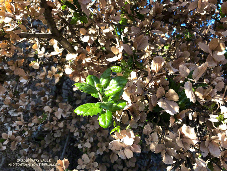
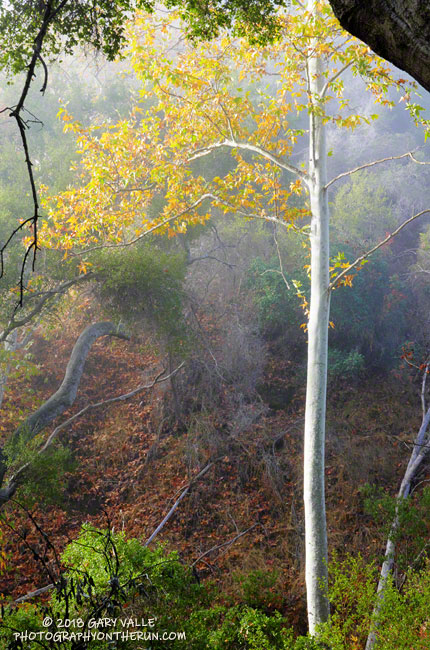
Many of the live oaks and valley oaks in the Woolsey Fire burn area have withered, brown, scorched leaves. As bad as they look, most of these trees will replace their foliage and recover.
Today I was excited to see foliage replacement occurring on several live oaks in the northeastern area of the fire. This also happened about a month after the 2005 Topanga Fire.
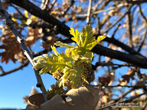
Sprouting valley oak leaves following the Woolsey Fire.
Back in 2005, valley oaks also started replacing their leaves about the same time as the live oaks. That might not happen this time. Valley oaks are deciduous and the Woolsey Fire occurred later in the Fall than the Topanga Fire. Now is about the time valley oaks would be losing their leaves. That may affect the timing of their foliage replacement. We’ll see!
Update January 2, 2019. Some valley oaks in the northeastern part of the Woolsey Fire area are starting to sprout new leaves!
I’d done a long run the day before in Pt. Mugu State Park, so the plan for this morning was to do a short run and check out the Woolsey Fire impacts between Century Lake and the M*A*S*H site in Malibu Creek State Park.
In addition to checking the condition of the coast live oaks and other native trees, I was curious to see how the coast redwoods along the Forest Trail had fared. These trees were planted nearly a century ago and in recent years have struggled with the drought. Had they survived the fire?
It had been about a year since I had checked on the redwoods. The good news is that a few of them still appear to be viable. The bottom limbs on some of the trees were scorched, but I think they will be OK. Of the 16 or so redwoods, about five have died, about five are in poor shape, and five or six appear to be OK. There is one young naturally occurring tree that was severely scorched and may not survive. We’ll just have to see.
While there was some damage to the M*A*S*H site, the picnic tables, ambulance, and signpost made it through the fire. Some repairs will be necessary.
I was supposed to turn around at the M*A*S*H site, but you know how that goes. I wanted to see “just a little” of the Bulldog climb… and a little more… and a little more. I finally ran out of time about 2.5 miles up Bulldog Mtwy and headed back.
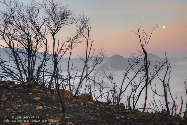
Even when you expect it, it is sobering to see areas of high soil burn severity. Thirty-six years of robust chaparral growth were just… gone. Also startling were the stream flows and debris flows that resulted from “only” about 1.5 – 2.0 inches of rainfall in early December. An atmospheric river event of the magnitude that caused the Malibu Creek flooding in February 2017 would be catastrophic.
A lot of work had been done on Bulldog Mtwy. It had been repaired and graded. Where there was still brush and trees along the road the branches had been trimmed!
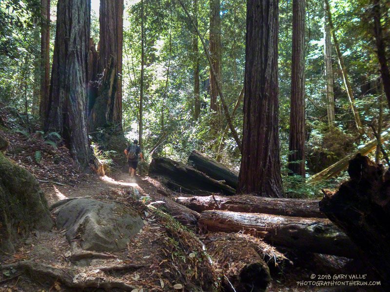
There’s a reason that Skyline to the Sea is Pacific Coast Trail Run’s biggest event. Close your eyes and picture your ideal trail. The trail of your dreams might be hard-pressed to match the appeal of the Skyline to Sea Trail.
There is something magical about running in an old-growth redwood forest. Established in 1902, Big Basin Redwoods State Park was the first state park in California. It’s redwoods reach 2000 years in age, 328 feet in height and 18.5 feet in width!
The Skyline to the Sea Trail has a net elevation loss, but enough uphill to get your attention. Many miles of the trail are as smooth as a carpet, but some are rocky, root-strewn and technical. It is often cool under the dense forest canopy, but it can also be warm and humid. I was surprised to see an “Emergency Water” stash a mile before the last aid station. In some years it is well-used and much appreciated.
The Park supports a vast variety of animal and plant life. Some plant species can only be found in the Park and a seabird (Marbled Murrelet) nests in its old-growth conifers.
In some years one park species can add extra adrenaline to the race. This year Brett (my son) and I were counting down the miles to mile 4.0 of the Marathon. The R.D. had reported encounters with the beasts at that point of the 50K on Saturday. About 20 yards before mile 4.0 Brett saw what looked like a “cloud of dust” and shortly after that we heard agitated voices from the runners ahead.
In it for the full experience, we — and several other runners — plowed headlong into the cloud. The yellowjackets didn’t like that. A number of us were stung; some several times. The day before a runner in the 50K was stung 18 times.
Yellowjackets or not, running the Skyline to the Sea Marathon was like running a 26 mile nature trail and one of the finest courses I’ve done.
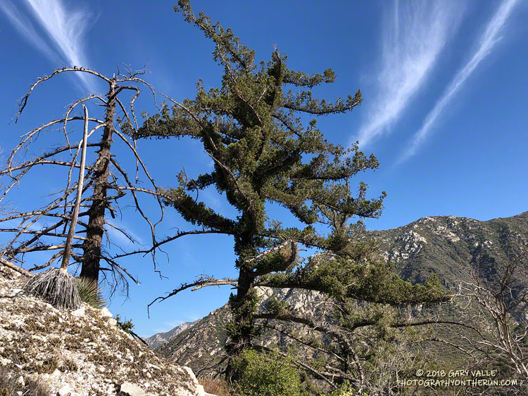
It’s been nine years since the Station Fire burned 160,577 acres in Angeles National Forest. The Red Box – Bear Canyon – Gabrielino loop is a long time favorite adventure run that I’ve enjoyed doing many years before and after that 2009 fire.
The loop was the first I did when the area reopened in May 2011. The trails were in poor shape — overgrown and damaged from flash floods. The notorious fire-follower Poodle-dog bush had flourished in the wake of the fire and was particularly bad along the Gabrielino Trail between Switzer’s and Red Box. Thinking I was “immune” to the plant, I brazenly plowed through it, and as a result spent several inflamed nights trying to sleep in a reclining chair.
Each year Bear Canyon and upper Arroyo Seco recover a little more. Poodle-dog bush is in decline and in many areas nearing the end of its life-cycle. The chaparral, bay trees and oaks are all recovering; and the bigcone Douglas-firs that survived the fire have become more fully-foliaged.
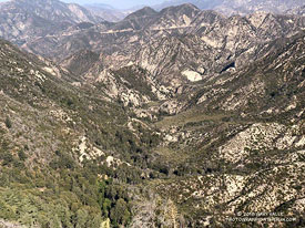
Bear Canyon from the upper Bear Canyon Trail. Click for larger image.
This year Bear Canyon was a little drier than last. The creek was a trickle, disappearing in the sand in some areas and creating small pools in others. The path in the upper part of the canyon, above Bear Canyon Camp, was better defined, but still tricky to follow in some spots.
With the dry conditions, most of the poison oak had already turned red. It was easy to spot, but difficult to avoid. The “stinging nettle” creek crossing higher in the canyon wasn’t as overgrown as last year, but I still managed to brush against a plant or two.
Bear Canyon ends at Arroyo Seco, downstream of Switzer Falls. After turning upstream on the Bear Canyon Trail, I hadn’t run far when I encountered a couple of mountain bikers. They asked me, “is this the trail to JPL?”
This wasn’t the first time that I’d encountered misplaced riders or hikers on this section of trail. Some get misplaced looking for the falls and others mistakenly follow the Bear Canyon Trail down into Arroyo Seco instead of continuing high in the canyon on the Gabrielino Trail. Because of the completion of the restoration of the Gabrielino Trail there were a few more riders on the trail than usual.