Category Archives: weather

Between Storms on the Backbone Trail

Fresh new leaves of poison oak hanging above the Backbone Trail

When one of the runners coming down the Rogers Road segment of the Backbone Trail saw me coming up the trail, he commented, “At least now we know the trail goes through!”

He was only half-joking. With all the wet weather, trails may not only be wet and muddy but might be flooded, severely eroded, blocked by trees and debris, or destroyed by runoff, mudslides, or slope failures.

Water droplets on bedstraw (aka cleavers) along the Backbone Trail

It had rained the previous two days, and more rain was forecast in a day or two. I was on this stretch of the Backbone Trail because I wanted to check out a use trail near High Point (Goat Peak) in the Santa Monica Mountains. I could do that by slightly modifying the route described in “Racing the Weather to High Point (Goat Peak) and Back.”

Two use trails connect to the High Point trail near High Point. Both are on the east side of the ridge. When traveling northbound from High Point, the first trail encountered is the “Rivas Ridge Trail.” Its junction with the High Point trail is on a hilltop, a bit more than a tenth of a mile north of High Point. The junction with the other trail — aptly named the “Great Escape” — is about a tenth of a mile north of the Rivas Ridge trail junction and a quarter-mile north of High Point.

Marine layer clouds in the Los Angeles Basin
West L.A and advancing marine layer clouds in the Los Angeles Basin.

Instead of doing the run as a pure out and back, on the way back, I took the Great Escape down to the Backbone Trail. This short use trail connects to the Backbone Trail about 0.4 mile south of “The Oak Tree.” It was an interesting trail to explore and only added about a third of a mile to the regular out-and-back route.

To show this variation, I’ve updated the interactive, 3D terrain view of the High Point (Goat Peak) Out and Back from the Top of Reseda.

Fuchsia-flowered gooseberry along the Backbone Trail

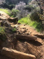
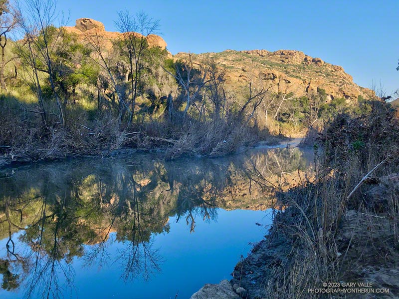
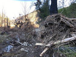
The condition of the Backbone Trail between Fire Road #30 and The Oak Tree was about what you would expect during such an active rain season. There were a few slimy, slippery spots and some eroded stretches of trail. My shoes and socks were already soaked from the wet grass along the trail by the time I reached The Mud Puddle. This was good because I didn’t waste any time looking for a way around the flooded section of trail — I just waded right in. Nearby, a short section of trail had collapsed in a slide, but there was enough of a shoulder to easily go around it.

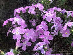
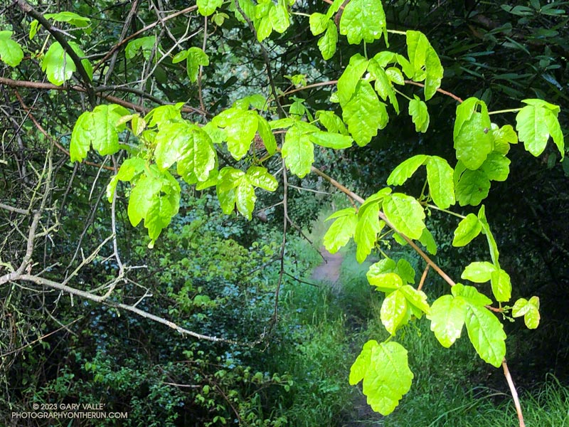
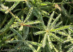
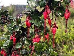
With the wet rain season, everything is growing like crazy. This includes poison oak, which was already dangling into the trail in several places. More wildflowers were beginning to bloom. This scarlet-red Fuchsia-flowered gooseberry was blooming along the Backbone Trail near its junction with the High Point Trail.

Some related posts: Racing the Weather to High Point (Goat Peak) and Back, High Point (Goat Peak) Via the Rivas Ridge Use Trail, Goat Peak and the High Point Trail

Snow-Covered San Gabriel Mountains From Lasky Mesa

Snow-covered San Gabriel Mountains from Lasky Mesa in Upper Las Virgenes Canyon Open Space Preserve (Ahmanson Ranch)

It had rained another inch overnight, and my shoes were soaked from the wet grass along the trail. Seeking some relief from the 20 mph northwest wind, I descended a single-track trail to an old paved road east of the ranch house on Lasky Mesa.

Motivated more by staying out of the wind than anything else, I did two sets of hill repeats on different sections of the road. Then, on tired legs, I jogged up to Lasky Mesa and was greeted by an Arctic blast. The temperature had dropped to the mid-40s, and the wind was blowing a steady 20 mph, gusting to around 30 mph. I didn’t need a wind chill chart to tell me the effective temperature was in the 30s.

I was so focused on dealing with the cold I wasn’t paying much attention to my surroundings. Deciding to do one more hill, I rounded a corner, and the brilliantly sunlit, snow-covered San Gabriel Mountains came into full view. It was just jaw-dropping!

Here is a wider view of most of the Front Range of the San Gabriels, white with snow.

Some related posts: Chasing Rainbows at Ahmanson Ranch, Looking for Snow on Topanga Lookout and Saddle Peak

Looking for Snow on Topanga Lookout and Saddle Peak

Castro Peak snow and Malibu Creek fog following 3-day storm in February 2023.
Castro Peak snow and Malibu Creek fog.

The paved turnout where I usually park at the Stunt Road trailhead was covered with mud, rocks, and debris. And near the entrance of Calabasas Peak fire road, two large boulders had been dragged to the shoulder to clear the road.

Following another big storm in a Winter of big storms, I was doing the Topanga Lookout Ridge Loop — curious to see what I could see. Nearby Stunt Ranch Reserve had recorded over 10 inches of rain the past three days, and there had been numerous reports of low elevation snow.

Here’s a slideshow of what I found.

Some related posts: Snow on Oat Mountain, Looking for Snow in the Santa Monica Mountains, Topanga Lookout Loop Plus Saddle Peak

Out and Back Trail Run from the Top of Reseda to Parker Mesa Overlook

Upper Santa Ynez Canyon and Eagle Rock from East Topanga Fire Road

The view from Parker Mesa Overlook was the uniform gray of the inside of a cloud. I was about 30 minutes too early, and the low clouds hadn’t cleared. The Pacific Ocean was out there somewhere.

Even so, the run from the Top of Reseda to the Overlook had been excellent. The hills and canyons were painted in a muted palette of sun and shadow. Purple-pink prickly phlox brightened the roadside, and the “Beech-nut Gum” scent of Bigpod Ceoanthus filled the air.

Prickly phlox along East Topanga Fire Road

Fire Road #30, Eagle Springs Fire Road, and East Topanga Fire Road had all been cleared of the sluffs and slides that resulted from January’s rainstorms. Overnight, there had been a little drizzle, but the fire roads hadn’t been muddy at all.

Rather than just retracing my steps, on the way back to the Top of Reseda I opted to do the Musch and Garapito Trails. I had run the Garapito Trail in mid-January but hadn’t been on the Musch Trail since the January deluge.

The Trippet Ranch parking lot had been packed, and several groups appeared to be on their way to Eagle Rock via the Musch Trail. Overall, the trail weathered the storms reasonably well, but one badly eroded section and a couple other spots will need some work.

Section of the Musch Trail damaged in January 2023 rainstorms.
Damaged section of the Musch Trail

While it still had some issues, use of the Garapito Trail had moderated its condition since the last time I was on it. Some brush that had blocked the trail had been removed, and paths were evolving through the collapsed sections of trail. However, some extra care was still required in some spots.

The Bent Arrow Trail was closed, necessitating a return to dirt Mulholland on Fire Road #30, following the same route as had been used at the beginning of the run.

Here is an interactive, 3D terrain view of a GPS track (yellow) to Parker Mesa Overlook from the Top of Reseda. The Bent Arrow Trail is temporarily closed for repair and is shown in red. To change the view, use the control on the upper right side of the screen. Track and placename locations are approximate and subject to errors. Poor weather and other conditions may make this route unsuitable for this activity.

Some related posts: More Malibu Creek Flooding, Looking for Storm Damage in Point Mugu State Park, Popular Trails in Topanga State Park Damaged by Winter Storms

More Malibu Creek Flooding (January 2023)

Malibu Creek near M*A*S*H site following January 2023 flooding
Malibu Creek near M*A*S*H site

April 26, 2023 Update. As it turns out, the shiny, new bridge on the Crags Road Trail that made it easy to cross Malibu Creek was not washed away! According to the Malibu Creek Docents, the bridge was designed to be portable, and was removed and stored before this Winter’s rain. It is expected to be reinstalled when the threat of flooding is over — which should be soon.

I was just a couple of miles into an extended version of the Bulldog Loop. The temperature was in the mid-30s, and once again, I was having to cross Malibu Creek on a makeshift bridge of wobbly limbs and debris.

Flood debris on the Crags Road Trail January 2023
Flood debris on the Crags Road Trail

The flood was the result of a series of three increasingly wet storms between December 30 and January 10. During that period, the Malibu Canyon RAWS recorded about 13 inches of rain. In the last storm of the series, 6 inches of rain was recorded in about 33 hours.

The flooding along the Crags Road Trail from the Forest Trail junction to the M*A*S*H site was similar to the February 2017 and December 2021 events. In the January 2023 event, more debris was deposited on the trail, and sections of the trail were obliterated. That stretch of trail is popular, and a new use trail is already taking shape.

Rainfall and runoff were even higher in Santa Barbara and Ventura Counties. The Rose Valley RAWS recorded over 22 inches of rain for the three storms. According to preliminary streamflow data, the Ventura River Near Ventura reached a new record stage height of 25.42 feet on January 9. The Sespe Creek Near Fillmore gage malfunctioned at the peak flow but reached at least 20.38 feet.

Some relate posts: Malibu Creek December 2021 Floods, Malibu Creek Flooding, Southern California Creeking