Category Archives: nature|trees

San Bruno Mountain and Windy Hill Trail Runs

California bay trees in Windy Hill Open Space Preserve near the bottom of the Razorback Ridge Trail.
California bay – Windy Hill Open Space Preserve

With vaccinations on the increase and Covid on the decline, it was wonderful to once again be able to visit family.

As we always try to do, Brett and I got in a couple of runs. We usually do at least one run that is new to me, and there are certainly plenty from which to choose in the Bay Area.

Oxeye Daisy along the Old Ranch Trail in San Bruno Mountain Park
Oxeye Daisy along the Old Ranch Trail

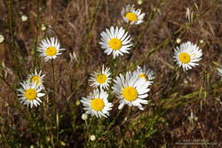
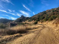
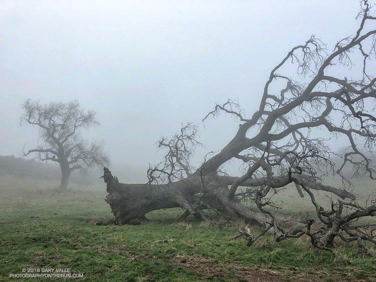
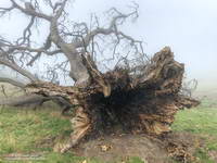
Our first run was on San Bruno Mountain. We’d previously done the Ridge Trail, so this time opted to do a variation of the Summit Loop. The parking lot at the base was was closed, so we started the run using the Old Ranch Road Trail. This was a plus because it added a little mileage and there were a lot of wildflowers along the trail, including monkeyflower, iris, lupine, yellow paintbrush, daisy, and foxglove.

Brett running up the Summit Loop Trail on San Bruno Mountain
Summit Loop Trail, near the top.

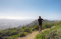
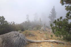
It was an excellent run on single-track trail. As is the rule on San Bruno, it was a bit breezy, with hazy views of the surrounding communities and the Pacific. An island of open space in an urban sea, San Bruno Mountain is a miracle of land conservation, and an area to be relished. Here is a map of trails in the area.

The next day, after watching a spirited youth soccer match, we headed south on 280. On the way, Brett filled me in on the runs he likes to do in Windy Hill Open Space Preserve and Huddart Park. We couldn’t go wrong with either choice but finally decided to save Huddart Park for another day.

Brett running through thimbleberry on a lush section of the Razorback Ridge Trail
Razorback Ridge Trail

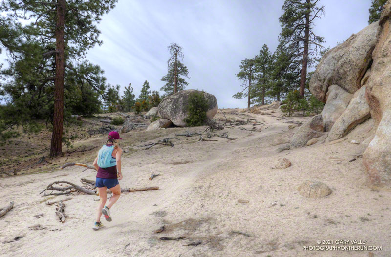
Windy Hill Open Space Preserve is on the northeast-facing slopes of the Santa Cruz Mountains above Portola Valley. We parked near the Alpine Trailhead and ran up the road to the Eagle Trail. Corte Madera Creek was running, but low. Although the grasses along the trail were green and the undergrowth was relatively lush, I suspect the conditions were more like July than May. Open hillsides looked mid-Summer dry and the lichen on the trees was drab and desiccated.

Like the rest of California, the Santa Cruz Mountains have seen well below average precipitation this rain season. One station near Windy Hill, Woodside 3.4 S, recorded only about 28% (12″) of normal precipitation from October 1 to May 19. Another station, Skyline Ridge Preserve, recorded about 41%  of normal (16.5″) from October 1 to May 3.

Western columbine along the Lost Trail in Windy Hill Open Space Preserve
Western columbine

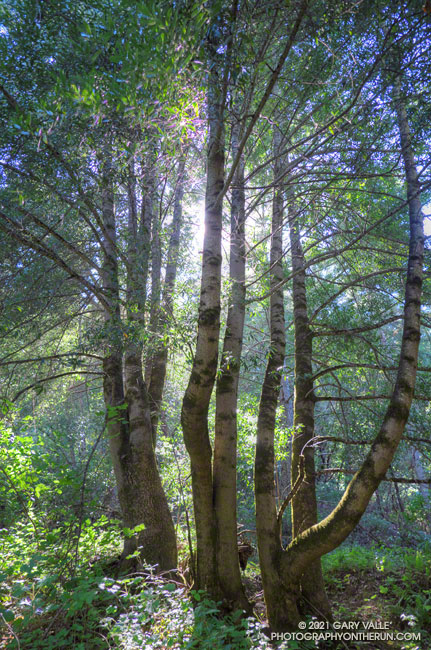
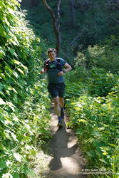
From the Eagle Trail/Private Road we turned onto the Razorback Ridge Trail. According to my Garmin track, the Razorback Ridge Trail gains 1000′ or so over 2.4 miles to its junction with the Lost Trail. It’s all runnable, switch-backing up a thimbleberry and fern-lined trail, shaded by California bay trees.

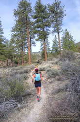
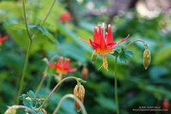
While the Razorback Ridge Trail continues up another 0.4 miles to Skyline Blvd., we turned right onto the Lost Trail. This trail parallels Skyline as it works in and out of the tributary ravines of Jones Gulch, on its way over to the Hamms Gulch Trail. Along the way there were views across the valley to Mt. Diablo, some 40 miles distant. Western columbine was blooming along the trail, its bright red color complimenting the green theme.

Large Douglas-fir along the Lost Trail in Windy Hill Open Space Preserve
Large Douglas-fir along the Lost Trail

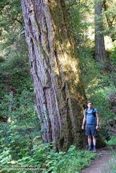
At the top of Jones Gulch, there is an impressive, old-growth Douglas-fir. At chest height, it is about as wide as Brett is tall. This would put its diameter at over 72″ and its circumference at over 220″, suggesting an age in the neighborhood of 350 years.

The run down the Hamms Gulch Trail was as good as the run up Razorback Ridge. Given the weather was nearly perfect for a hike or run, we were surprised to see only a dozen or so people on the trail.

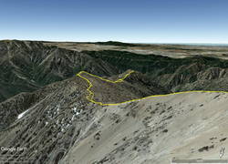
From where we were parked the run worked out to about 8 miles, with about 1500′ of gain/loss. Here is a trail map of the area, and here is an interactive, 3D terrain view of my GPS track of the loop. The interactive map can be zoomed, tilted, rotated, and panned. To change the view, use the control on the upper right side of the screen.

Some related posts: Breezy San Bruno Mountain Ridge, San Francisco Sights Trail Run, Miwok Wanderings

Return to Ross Mountain

South Ridge of Mt. Baden-Powell about a mile from Ross Mountain

When I started up the trail from Vincent Gap (6585′), the thermometer on my pack read 36°F. For the first few switchbacks, the trail was immersed in cloud. Beneath the tall conifers, the sandy soil was dotted with droplets of moisture extracted from the fog.

Google Earth image of GPS track down the South Ridge of Mt. Baden-Powell to Ross Mountain

I was on my way to Ross Mountain (7402′), one of the most isolated peaks in the San Gabriel Mountains. At the end of a rugged, 3-mile ridge extending south from the summit of Mt. Baden-Powell, the peak overlooks the vast canyons of the Sheep Mountain Wilderness.

This morning, the canyons were filled with a 7000′ deep layer of stratus clouds. With a weak upper low over the Southern Sierra, the question of the day was whether the cloud deck would work up the ridge from Ross Mountain and completely envelop Baden-Powell.

Summit of Mt. Baden-Powell. May 16, 2021.

Well acquainted with the trail up Baden-Powell, a combination of fast-hiking and slow-jogging put me on top in a relatively comfortable 90 minutes. I’d tried not to overdo the pace, knowing from previous experience that the return from Ross Mountain would be the tough part of the day.

From the summit of Baden-Powell, I gazed across the sea of clouds to Mt. Baldy. There was almost no snow on its steep north face. San Gorgonio Mountain was visible in the haze to the left of Pine Mountain and San Jacinto Peak in the gap between Dawson Peak and Mt. Baldy.

South Ridge of Mt. Baden-Powell with Ross Mountain partially visible in the clouds

Walking a little down the south side of Baden-Powell, I got my first good look at the South Ridge. Ross Mountain was nearly covered in clouds. Guessing that the deck of clouds might deepen, and a few minutes might make the difference of being in the clouds or out, I started to jog-lope-shuffle down the initial steep slope.

The title photo was taken a bit past Peak 8375, about 1.7 miles from Baden-Powell and 1.2 miles from Ross Mountain. At that time the clouds were spilling over the ridge near Peak 7407 and Peak 7360+, and around Ross Mountain.

Just north of Peak 7407 on the South Ridge of Mt. Baden-Powell
Into the clouds near Peak 7407

The clouds added an aesthetic element to the adventure, as well as a little uncertainty. They accentuated and embellished the terrain, while threatening to make the conditions wet, cold and disorienting. Being familiar with the route helped me to enjoy the experience more than the concerns.

After navigating the false summits along the final stretch of ridge, I finally reached Ross. And, of course, it was in the clouds. That was the tradeoff for the spectacular views of the clouds along the ridge.

I didn’t spend much time on the summit. The more time I could spend out of the clouds, the more enjoyable would be the 2200’+ climb back to Baden-Powell.

It took a little over two hours for the clouds to chase me back up the ridge, but only an hour to run the four miles down from Baden-Powell to the foggy trailhead.

Related post: Excursion to Ross Mountain

Three Points – Mt. Hillyer Loop

Trail runner on the Mt. Hillyer Trail in the San Gabriel Mountains
Mt. Hillyer Trail

Snow — if there has been snow — disappears quickly from the middle elevations of the San Gabriels this time of year. Activity increases with the rising snowline, as visitors eye their favorite trails and peaks.

I was driving up Hwy 2 to Three Points to do a run with Skye. In a normal year we would be doing the Three Points – Mt. Waterman Loop, but for the second time in 11 years, the trails in the Mt. Waterman area had been closed by a wildfire. In 2009, the Station Fire burned 160,557 acres in the San Gabriel Mountains, and just last year, the Bobcat Fire burned 115,796 acres. In several places, including Mt. Waterman, the Bobcat Fire burned terrain that had been burned in the Station Fire.

Coulter pine cone, heavy with resin

With entry prohibited in most of the Bobcat Fire burn area, the Three Points Loop around Mt. Waterman was out for now. Instead, we decided to do a segment of the traditional AC100 course from Three Points to Chilao, and then return to Three Points using the Silver Moccasin Trail.

Here’s an overview of both the Three Points – Mt. Hillyer Loop (yellow) and the Three Points – Mt. Waterman Loop (red). An overlay of the Bobcat Fire BAER Soil Burn Severity has ben added to the Google Earth image. The burn severity classes are high (red), moderate (yellow), low (light green), unburned/very low (dark green), and no data (black). Trail and placemark locations are approximate.

Trail runner on the PCT near Sulphur Springs Road
PCT near Sulphur Springs Road

On today’s run we followed the Pacific Crest Trail northbound from Three Points toward Sulphur Springs Trail Camp. Just before the camp, the PCT splits. We followed the left fork (uphill), and then around to the South Fork Little Rock Creek drainage and Sulphur Springs Road. The PCT parallels the road for about a half-mile, then crosses the road. At this point we left the PCT behind and continued up the road (5N04) to Alder Saddle and forest road 3N17. We continued left (south) on 3N17, bearing left on Santa Clara Divide Road at a fork, and going uphill to Rosenita Saddle.

At Rosenita Saddle we turned right (southwest) onto the Mt. Hillyer Trail. The trail starts at the back of a small parking area. The trail climbs to the high point of Mt. Hillyer, and then descends through large granite boulders in the Horse Flats bouldering area. (If you are a rock climber, bring your shoes!) The Mt. Hillyer Trail intersects the Silver Moccasin Trail near the Horse Flats Campground.

To add a little mileage and elevation gain, we turned right (south) on the Silver Moccasin Trail and continued to Chilao Campground. After saying hi to Chilao, we turned around and followed the Silver Moccasin Trail north, back to Three Points.

The trail run was a little over 13 miles, with a cumulative elevation gain of about 2100′. The high point was about 6200′, on Mt. Hillyer. The route-finding on the loop can be a bit tricky the first time around.

Moon and Sycamores, Malibu Creek State Park

Moon and Sycamores, Malibu Creek State Park

The photograph Moon and Sycamores was taken at dawn, near Malibu Canyon and Piuma Road, at the start of this morning’s Bulldog Loop trail run in Malibu Creek State Park.

A quarter-mile from the top of Bulldog Mtwy fire road in Malibu Creek State Park.
A quarter-mile from the top of the Bulldog climb.

According to the Tempe sensor on my pack, the temperature ranged from a chilly 32° F along Malibu Creek to around 65° F on the crest. It was a near perfect morning to be outdoors.

Here’s an interactive, 3D terrain view of my GPS track from a previous run of the Bulldog Loop from Malibu & Piuma.

Some related posts: Bulldog Loop Plus the Phantom Loop; Trees, Bees, and a Washed-Out Footbridge on the Bulldog Loop in Malibu Creek State Park; After the Woolsey Fire: Bulldog Loop

Rivas Canyon Eucalyptus

What is it? Photography by Gary Valle'.

These shallow channels looked like they might have been cut by a woodworker’s router. But they were cut — or I should say chewed — by Longhorned Borer beetle larvae, feeding on the cambium of a eucalyptus tree.

Fallen eucalyptus in Rivas Canyon. The grooves are from beetle larvae feeding on the cambium of the tree.

The tree was across the trail in Rivas Canyon. Not unlike the fallen oak on Rocky Peak, Southern California’s multi-year drought likely weakened the eucalyptus, making it susceptible to other pests.

The Rivas Canyon Trail connects Will Rogers State Park to Temescal Canyon. Today (and last weekend) I ran it as part of a long loop from the “End of Reseda” at Marvin Braude Mulholland Gateway Park.

Some related posts: Will Rogers – Temescal Loop, Will Rogers Western Ranch House, Downtown Los Angeles and San Jacinto Peak

Fallen Oak

A large valley oak along Rocky Peak fire road that toppled following five years of drought.

The fallen oak pictured above — one of the larger valley oaks along Rocky Peak fire road — toppled over in the summer of 2016 following five years of drought. Fire and drought are a natural part of the valley oak’s habitat and the trees have evolved to withstand ordinary variations in their environment. However, severe fires or extended droughts, or fire in combination with drought can overcome the tree’s defenses. The drought may have been the culminating factor in the felling of this oak, but fire and other factors may have also played a role.

Base of large valley oak along Rocky Peak fire road that toppled following five years of drought.
Base of large valley oak that toppled following five years of drought. Click for larger image.

According to the Fire Effects Information System (FEIS), the heart-rot fungus Armillaria mellea is usually present in valley oaks and larger oaks tend to be hollow or rotten in the center. The toppled oak was hollow near its base and its interior appears to have been blackened by fire. The FEIS describes instances where the decaying wood in the interior of older valley oaks could ignite in a fire, but leave the exterior bark uncharred.

What fire might have burned the tree? There are two possibilities: the 2008 Sesnon Fire and the 2003 Simi Fire. It probably wasn’t the Sesnon Fire — this photo of the tree, taken about a month after the Sesnon fire, shows little impact. I couldn’t find a photo of the tree following the Simi Fire, but photos taken nearby show a severely burned landscape. Ultimately, it appears fire and drought weakened the tree, accelerating its heart rot and weakening its roots to the point it could no longer support itself.

Photos of the fallen oak are from this morning’s foggy run along Rocky Peak fire road.

Related post: Ahmanson Blue Oak Succumbs to Climate ChangeChumash Trail – Sesnon & Simi Fires