Category Archives: nature|weather

Southern California Rain and the 2009-2010 El Niño

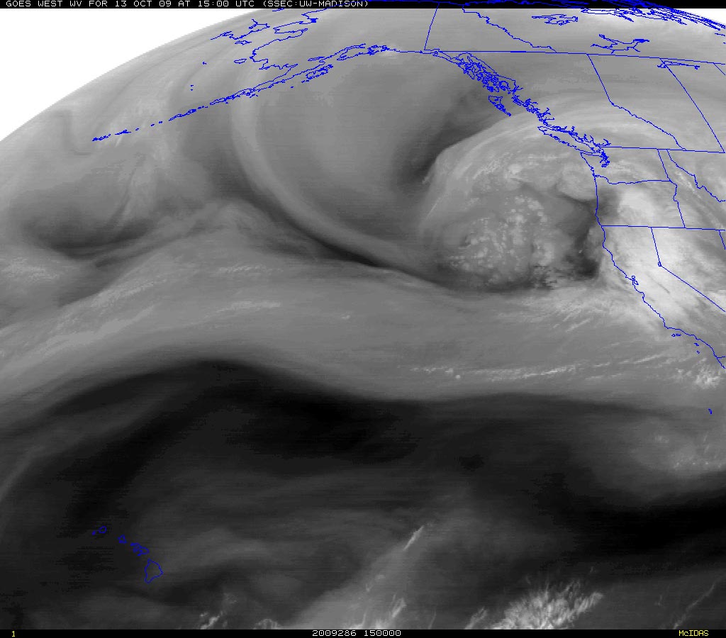
Who would think a western Pacific typhoon could so directly affect California’s weather? But that’s what is happening. The moisture from typhoon Melor, which was over Japan just a few days ago, was captured by an extending and strengthening jet stream. This has resulted in an atmospheric river of moisture, stretching across the Pacific and into California.


This morning, Intellicast composite radar shows Northern and Central California already being hammered by the system. Southern California has seen a few showers, and several stations have already recorded significant rainfall. As of 9:00 a.m. the CNRFC Precipitation Map shows isolated 24 hr. rainfall amounts in the foothills and mountains of Santa Barbara, Ventura, and Los Angeles County ranging from about 0.16 inch at Sandberg to 0.61 inch at West Big Pine.

The last day there was measurable rainfall at Downtown Los Angeles (USC) was on June 5, 2009, when 0.13 inch was recorded. Computer weather models forecast the best dynamics and highest rainfall totals will be in the northern two-thirds of the state, but in recent days have been trending wetter in the Los Angeles area, particularly in the mountains.

With so much moisture in the atmosphere, it takes very little lift to produce rain. Onshore winds, full of moisture, are lifted by foothills and mountains across the flow, and the result is rain — sometimes lots of it. In this case it appears the south to west facing mountains and foothills of Santa Barbara, Ventura and Los Angeles counties may record much higher rainfall totals than the lowland areas.

In a decade characterized by unusual El Ninos, the ongoing El Niño of 2009-2010 is another strange one. El Niño signals continue mixed. The Aug-Sep Multivariate ENSO Index (MEI), decreased from 0.978 to 0.754, however other El Niño signals appear to be rebounding. In the last two weeks low level equatorial westerly anomalies have increased significantly. The reduction in the strength of the trade winds, and a downwelling Kelvin wave resulting from a very strong westerly wind burst already appear to be increasing upper ocean heat content in the central equatorial Pacific. The 30 day moving Southern Oscillation Index (SOI) has been dropping, and should return to negative territory in a day or so.

Recurring equatorial westerly wind bursts and enhanced west-central Pacific convection has been slowly migrating eastward. The most recent round of enhanced convection was centered at about 160E. This is consistent with a developing El Niño, and may have contributed to the creation of the atmospheric river now affecting California, by helping to extend the Pacific jet stream following an East Asian mountain torque event.

However, total and relative AAM remain negative, and are lower than is generally the case during a developing El Niño. Of the weak to moderate El Ninos that have occurred Since 1959, only the 1977-78 and 1994-95 El Niños have had negative average July-September relative AAM values comparable to the current El Niño. Since 1959, only 4 of 15 El Niños have had negative average relative AAM values during the Southern California rain season of November to March. (Revised 12/14/09)

Moderate El Niños come in many flavors and have varying impacts. Under the guise of such El Niños Los Angeles experienced its second wettest water year on record in 2004-2005, when 37.25 inches of rain was recorded; then in 2006-2007 had its driest water year on record, when only 3.21″ was recorded. What flavor will the 2009-2010 El Niño be?

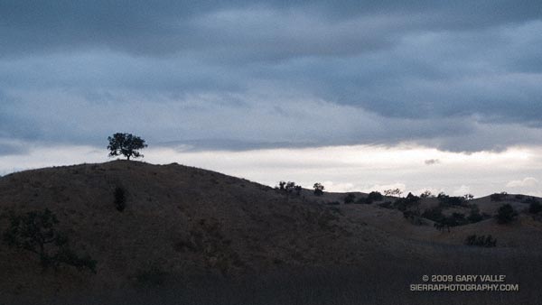
The photo of the tree and clouds is from yesterday’s run at Ahmanson Ranch.

Related post: How Does the El Nino of 2009-10 Compare to Other Warm ENSO Episodes Since 1950?

Climate Change and the Southern Foxtail Pine

Windward side of a southern foxtail pine snag.

The windward side of this foxtail pine snag has been blasted by the icy winds of a multitude of Winter storms. The wind has sculpted the mineral-like wood, exposing and accentuating its inner layers.

The photo is from last Saturday’s Cottonwood Pass – New Army Pass trail run. Nearly all of this route is above 10,000 ft. and 12 miles of it are above 11,000 ft. This relatively dry, high altitude habitat is home to the southern foxtail pine (Pinus balfouriana subsp. austrina).

One of the less common Sierra conifers, the tree is a long-lived species that is closely related to the bristlecone pine. The FEIS database references a southern foxtail pine 3400 years old, and the Gymnosperm Database a specimen with a crossdated age of 2110 years.

Because the tree grows so slowly, the wood is dense, and dead trees are slow to decay. In the vicinity of Cirque Peak, and a few other areas, dead foxtail pines and remnants are found above the current tree line. By crossdating tree ring sequences, a study published in 1997 found that over the past 3500 years the tree line in this part of the Sierra has generally been higher than it is now.

The study deduced that one period of reduced tree abundance and lowered tree line elevation was associated with warmer temperatures, and at least two severe multi-decade droughts. In contrast, the most recent decline has occurred during a cold, wet period that started about 450 BP.

It is remarkable that some of the dead foxtail pines studied here were alive during the Bronze Age, 4000 years BP.

Ramping Down for Mt. Disappointment

Live oaks at Sage Ranch Park.

Note: The Mt. Disappointment Endurance Run is now the Angeles National Forest Trail Race.

Or should that be ramping UP for Mt. Disappointment? Anyway, started tapering for the Mt. Disappointment run next Saturday. Did the 13 mile Cheeseboro Canyon keyhole loop from the Victory Trailhead of Ahmanson Ranch yesterday, and then stretched the legs at Sage Ranch today. Both mornings were cool, with low clouds and fog — very pleasant!


Spider web
Here’s hoping for “not too hot” weather for the race. At the moment, the GFS and ECMWF weather models show a weak upper level trough moving through California in the Friday-Saturday timeframe. Such a scenario should increase the chances of “seasonable” temps for the race — which would still be quite warm, but maybe not crazy hot.

Update Friday Morning 8/07/09. Broad upper level trough over California this morning is keeping things cool. Yesterday the high recorded at Mt. Wilson was 70, and the low overnight was 48! Southern part of the trough is forecast to hang back over Southern California through Saturday, which could result in temps a little BELOW normal for the Mt. Disappointment race. We’ll see!

Related post: Mt. Disappointment 50K 2008 Notes

Summer Returns

Poison Oak along the Blue Canyon Trail.

Poison Oak Along the Blue Canyon Trail.

Since nearly all my weekday runs are in the afternoon, on Summer weekends I usually like to escape the heat and do a run in the mountains — the higher, the better. But today even the mountains were going to be hot. Hot enough that the National Weather Service had issued an Excessive Heat Warning for a combination of heat and humidity that would “create a dangerous situation in which heat illnesses are likely.”

It would be cooler at the higher elevations of the Sierra, but there was good chance of thunderstorms developing along the crest of the Sierra, as well as most of the higher mountains of Southern California. Considering the options, I finally decided to do an early morning run in Pt. Mugu State Park. If I was going to run in the heat, it might as well be a scenic run close to home. Maybe the weather in the mountains would be better next weekend.


Sunrise on the Satwiwa loop trail.
There are many excellent courses at Pt. Mugu State Park. The course I was doing today is a “backward” variant of the Boney Mountain Half Marathon Course — up the Old Boney Trail, down to the Danielson Multi-use area, up Ranch Center fire road to the Hidden Pond Trail, and then back on the Upper Sycamore Trail. Water is normally available at Danielson Multi-use area and at the start of the Upper Sycamore Trail.

I should have started the run at dawn, but instead ambled along a section of the Satwiwa Loop trail at sunrise. The light was muted and golden, stretching my shadow well out on the trail ahead. Cool trickles of air filled each dip and gully and I wondered how long the temperate conditions would last. Ironically, the last time I had done this course it had been blustery and cold, and there had been snow on the mountains above Ventura. Not today…


Crags above the Danielson cabin site on Boney Mountain.
It was warm running up the east facing section of the Old Boney Trail, but not yet hot. The crags to the west of the Danielson cabin site, gleamed in the morning sun, and for a brief instant I debated climbing the ridge. The impulse passed, and once over the shoulder of Boney Mountain, I thoroughly enjoyed the (mostly) downhill running through the Boney Mountain Wilderness to the Blue Canyon Trail junction. Cool air draining from the shaded slopes of Boney Mountain kept temps reasonable in the canyon, and the running was good all the way to the Danielson Multi-use area.


Descending to the Old Boney and Blue Canyon trail junction.
At the Multi-use area there is a choice. The coolest and most direct route to the Upper Sycamore Trail is up shaded (and paved) Sycamore Canyon road. But with the Mt Disappointment race looming, I wanted to get in more time and elevation gain, so opted for the longer, more exposed route up the Ranch Center fire road, and then along the ridge on the Hidden Pond Trail. Yes it was hot, and the humidity was up a bit, but it was still scenic and enjoyable in a “I’m not going to let the heat get to me” kind of way. And I knew a water faucet was waiting for me at the point where the Hidden Pond Trail rejoins Sycamore Canyon road, and the Upper Sycamore Trail continues eastward.

Maybe it was the heat, or maybe the coyote had learned to scavenge food from hikers — whatever the case the coyote ahead of me on the Upper Sycamore trail didn’t seem to be in any particular hurry to get off the trail. Coyotes are an odd sort, very intelligent and adaptable, but in my experience not normally any kind of threat.

Usually they will scurry away from a runner. This coyote wasn’t scurrying anywhere. I picked up the pace and clapped my hands, and eventually the animal grudgingly took cover to the side of the trail. But, as it turns out, only about 4 feet off the trail. This was odd, brazen behavior, and I kept a wary eye as I passed.

The final challenge of the morning was the hot climb up to Satwiwa on the Danielson road from the end of the Upper Sycamore Trail. The hill isn’t long or particularly steep, but it faces directly into the sun. With the heat of the day building, it wasn’t easy.

Overall it was an excellent run that would have been even better with an earlier start. Here’s a Cesium browser View of a GPS trace of the approximately 14.5 mile route.

Related post: Big Sycamore Canyon Circuit

Cool Running in Southern California

Dave Burke cruising down a nice section of the PCT between Cloudburst Summit and Cooper Canyon.

Last year on this date, Southern California was in the middle of a heatwave. On June 20, 2008, Los Angeles Pierce College in Woodland Hills reached a record-setting high of 111°F, and on June 21 the temp reached 108°F!


Snow plant
Not so this June! So far this month, Downtown Los Angeles has not had a day when the average temperature was above normal. And it’s not only the low elevation stations that have been cool. Several times this month the overnight low at the Big Pines RAWS, near Wrightwood in the San Gabriel Mountains, has dropped into the thirties, and daytime temps have averaged more than 10 degrees below normal.


Three Points - Mt. Waterman Trail, west of the Twin Peaks Trail junction.
This translates to great running weather in Southern California, and near perfect weather for trail running in the San Gabriel Mountains. Today, did the Three Points – Buckhorn loop, along with a short detour up to the summit of Waterman Mountain. The route worked out to about 23 miles with a reality-checked elevation gain/loss of about 3800′. Here’s a Cesium browser View of a GPS trace of the run.

The title photo is of Dave Burke, cruising down a nice section of the PCT between Cloudburst Summit and Cooper Canyon.

Related post: Three Points Loop Plus Mt. Waterman

PCT from Inspiration Point to Islip Saddle

View from near the summit of Mt. Baden-Powell.

Overnight the lows on the high peaks had dipped into the 30’s, and today the high temps would be 15-20 degrees below normal. If I could have ordered the perfect mix of temperature, clouds and sun for running in the Angeles high country, it would be difficult to top the weather this weekend and last.


Clouds and pines along south ridge of Mt. Baden-Powell in the San Gabriel Mountains.
Now that Hwy 2 was open between Islip Saddle and Vincent Gap, and we could do a car shuttle, Miklos, Krisztina and I had decided to run from Inspiration Point to Islip Saddle on the PCT. Starting at Inspiration Point instead of Vincent Gap adds about 4.5 miles to the run, but the miles are relatively easy, and the stretch is a good warmup for the 2800 ft. climb up Mt. Baden-Powell.

Here’s a Cesium browser View of a GPS trace of our approximately 18 mile route. We wandered down the south ridge of Mt. Baden-Powell, so this is a little longer than the usual route. The elevation gain was about 3300 ft., with an elevation loss of about 4000 ft. Continuing over Mt. Williamson to Eagle’s Roost would add about 4 miles and 1400 ft. of elevation gain.

Note: The speck in the summit photo is one of several violet-green swallows working lift and zooming along the top of southeast face.