Category Archives: nature|weather

Up & Down Mt. Baldy’s South Ridge

Hikers above the clouds on Mt. Baldy's South Ridge.
Mt. Baldy’s South Ridge.

One, two, ten…
Will the switchbacks ever end?

I can’t think of a tougher stretch of trail in the San Gabriel Mountains. From Mt. Baldy Village, the Bear Canyon/Old Mt. Baldy Trail climbs 5800′ in 6.7 miles to the 10,064′ summit of Mt. Baldy (Mt. San Antonio). The route is as rewarding as it is difficult, with inspiring views and interesting terrain.

I had hoped for some remnant clouds from Friday’s storms, but didn’t expect to be using my windshield wipers driving to the trailhead. The dark gray clouds piled against the mountains had a scuddy, stormy look, and I had a difficult time convincing myself that it was just a deep marine layer. But the sun was shining when I parked at the bottom of Bear Canyon Rd. and began to walk up the steep, cabin-lined street.

Clouds pushing up San Antonio Canyon and the southeastern slopes of Mt. Baldy.

The last time I had been on the trail was July 2004, during the Baldy Peaks 50K. That day we started at the parking lot at Icehouse Canyon, and over the course of the race climbed Mt. Baldy twice. The first time from the Village, and the second time from Manker Flats. Today I wasn’t in a race, and would be completely satisfied to climb Mt. Baldy just once.

Running up a moderate section of trail below Bear Flat, I tried to figure out the last time I had run down the Bear Canyon Trail. Sometime before the Baldy Peaks race. I wasn’t sure how long it had been, but long enough to forget how grueling steep downhill can be.

My thoughts are interrupted by a pair of hikers coming down the trail. I ask how they’re doing, and am surprised to hear, “not so good.” They look disappointed and tired, and anxious to get down to the car. I wonder if one of them is ill, or if they just underestimated the difficulty of the trail.

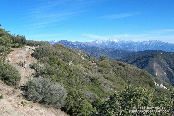
A half-mile later I’m crossing the creek at Bear Flat (~5500′). This is where the fun begins. Here the trail switchbacks up a steep east-southeast facing chaparral slope to Mt. Baldy’s South Ridge, gaining about 1500′ in one mile. On a warm day it can be hellish. On a cool day it isn’t easy. Today it is cool. The cloud layer has continued to crawl up the mountain, and it envelops me as I start up the switchbacks.

A little more than a year ago, these slopes were burned in the 2008 Bighorn Fire. I had expected to see black, burned and barren chaparral in the initial stage of recovery, but instead there is substantial growth, comparable to 2-3 years of recovery in chaparral at a lower elevation.

Video snapshot from Mt. Baldy's South Ridge.
Click for video snapshot from Mt. Baldy’s South Ridge.

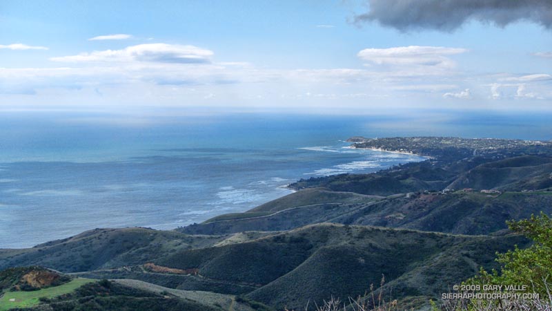
At an elevation of about 7000′, I climb out of the clouds and into the sun. What a day! Benign clouds lap at the mountainside, enhancing already dramatic views. Between 7000′ and 9000′, I encounter several hikers and briefly chat with one veteran hiker, who tells me this is his friend’s intro to hiking! It is a busy day for this trail, and I’m guessing I’ll see more hikers when I descend.

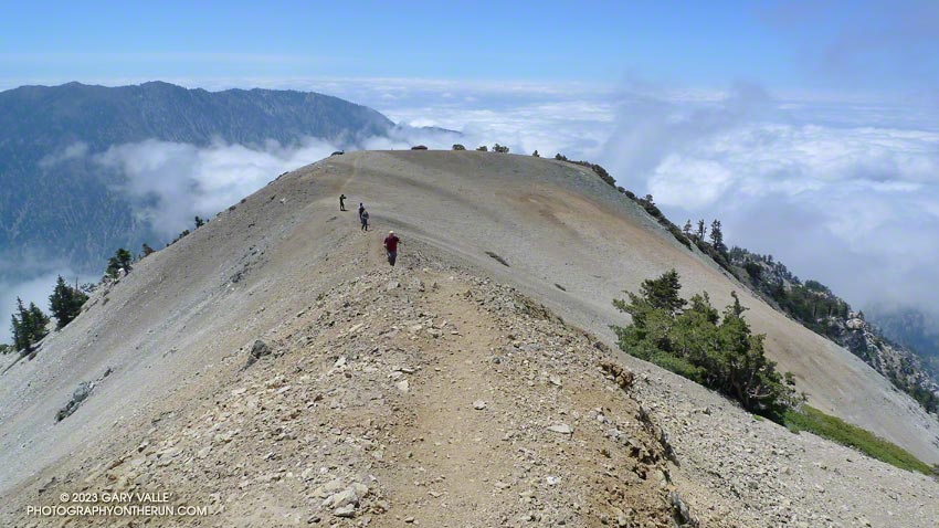
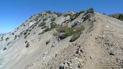
Above 9000′ the open forest of Jeffrey, Sugar and Lodgepole pine becomes more sparse and stunted. The route feels more alpine and climbs onto the rocky crest of an exposed ridge (HD Video Snapshot). A little higher, a large patch of snow accentuates the “you’re getting near tree line” feeling.

Hiker leaving the summit of Mt. Baldy, and starting the descent of the Ski Hut trail.

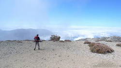
Approaching Baldy’s summit, I’m surprised to see a wispy cloud had also ascended the peak and is waiting for me to catch up. On top there seems to be a mix of young and old, veterans and first-timers, excitement and exhaustion. After a few minutes on the summit, I run over to West Baldy. Then it is gravity’s turn, and I take the first steps down the slope.

The descent is just as extraordinary as the ascent, with far-reaching mountain views over a sea of clouds. On an exposed section of the ridge at about the 8500′ I happen on a Sugar pine with a spiral scar from a lightning strike. Such trees are disturbingly common. There is a Jeffrey pine at about the same elevation on Mt. Baldy’s North Backbone Trail with a similar lightning scar.

Ferns at Bear Flat
Ferns at Bear Flat

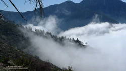
At around 7500′, I descend into the clouds. The change from blue to gray does not carry with it the usual malaise. Wisps of warm cloud thread softly through the pines and a solitary deer walks silently through the dream-like scene (Video snapshot).

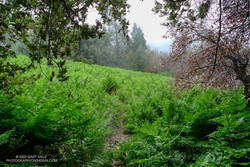
One, two, ten… Will the switchbacks ever end? Finally, through the trees I see the brilliant green of the ferns at Bear Flat. Running becomes easier. I pick up the pace, and in a few minutes turn onto the asphalt of Bear Canyon road.

Here is an interactive, 3D terrain view of a GPS trace of my route on the Mt. Baldy’s  South Ridge on the Bear Canyon/Old Mt. Baldy Trail. The map can be zoomed, tilted, rotated, and panned using the navigation control on the right. Track and placename locations are approximate and subject to errors. Snow, ice, poor weather, and other conditions may make this route unsuitable for this activity.

Some related posts: Mt. Baldy Runner, Lightning Tree

Southern California Thunderstorms an El Nino Calling Card?

Valley oak on Lasky Mesa, with a line of thunderstorms in the distance.

Off to the south, I heard the distant rumble of thunder. The developing line of thunderstorms had swept through the West Valley about an hour before I began my run at Ahmanson Ranch.

Unusual weather for June. Not so much that there were thunderstorms, but that the thunderstorms were in part the result of an unseasonably strong jet embedded in the base of an upper level low.

It’s a bit of a stretch, but an argument could be made that these storms were a calling card of an increasingly energetic atmosphere, and a developing El Niño.

Several factors point to an increased probability of El Niño conditions developing over the next few months. Among them, Equatorial Pacific SSTs have increased, and the subsurface heat content is the highest it’s been since the El Niño of 2006-07.

But as the short-lived 2006-07 El Niño event demonstrates, an El Niño is more than just warm Pacific equatorial SSTs. Through complex forcing and feedback mechanisms, the atmosphere and oceans have to cooperate on a global scale. Generally speaking the atmosphere speeds up when there is an El Niño, and slows down during a La Nina.

And it looks like the atmosphere may be speeding up. Orbits of the Global Wind Oscillation, a measure of atmospheric momentum, have been shifting upward, in the direction of more energetic values usually associated with an El Niño.

But an El Niño is not a done deal. The climate system is just leaning in that direction. As climate scientist Klaus Wolter has pointed out, in a similar situation in 1973-1975, the climate fell back into a La Niña for another year. At this point it appears we may be diverging from that analog case. We’ll see!

Update June 6, 2009. The April-May Multivariate ENSO Index (MEI) value, released today, has increased by 0.54 to +0.34. As discussed by MEI originator, Klaus Wolter, the 3-month rise of the MEI since January-February is the 4th highest on record for this time of year, exceeded only by the strong Niño of 1997. According to Dr. Wolter, if next month’s MEI rank is at least the same as this month (37th), “it would be unprecedented for it to drop below that high-neutral ENSO-phase range by the end of 2009, virtually excluding a return to La Niña, based on the MEI record since 1950.”

Related links: ENSO Diagnostic Discussion, ENSO Wrap-Up

Rocky Peak Running Weather

View northwest from Rocky Peak

Brrr… I picked up the pace — even with long sleeves it was COLD on Rocky Peak Road. Another in a series of blustery April systems was stirring up the weather in Southern California. Thickening clouds spritzed rain, and a belligerent wind told me in laughing gusts that I could not run fast enough to stay warm.

Occasionally a patch of sun would find its way through the clouds, briefly warm and encouraging. I needed only  to think of the 100 degree days ahead to appreciate the chilly temps.

Another cool system is forecast to move through Southern California on Friday, bringing with it a chance of rain — and more great running weather. Easter weekend should be spectacular!

Some related posts: Simi Valley from Rocky Peak, San Fernando Valley from Rocky Peak

Southern California Warming Up and Drying Out?

Trail leading to Lasky Mesa at Ahmanson Ranch.

There are still a few rogue mud puddles out at Ahmanson ranch, but the Goldfields are blooming, the meadowlarks singing, and it feels like Spring!

Last week it looked like our rain season might not be over. Now I’m beginning to wonder. This week the GFS and ECMWF forecasts have been much drier in Southern California, with most of the activity focused on the Pacific Northwest. No significant rain is forecast here over the next week, and both the 6-10 and 8-14 day forecasts project below average precipitation in Southern California.

If these medium range forecasts are on the mark, March rainfall for Downtown Los Angeles (USC) will fall well below the 3.14 inch norm. Normal April rainfall is 0.83 inches, and May only 0.31 inches. Beyond March it becomes increasingly unlikely that a big rain event will significantly boost our rainfall total.

Since November 1, Downtown Los Angeles has recorded 8.80 inches of precipitation. This is about what would be expected during a La Nina, and within the range indicated in the composite precipitation map included in the post Southern California 2008-2009 Winter Precipitation Outlook, back in October.

In his March 6 post, Ed Berry suggested the possibility of “more energetic progressive troughs” in the western U.S in the week 2-3 timeframe. That wouldn’t necessarily result in rain in Southern California, but might improve our chances. Numerical weather model performance generally suffers during seasonal transitions, so maybe there are still some surprises lurking in the Pacific. We’ll see!

Malibu Creek State Park Shadow & Sun

Malibu Creek State Park

My trail running shoes had not been wet or muddy since sometime in December. During the entire month of January, Downtown Los Angeles (USC) recorded about one-third of an inch of rain. Not only had it been dry, it had been warm. On a dozen of those January days, the high temperature topped eighty degrees, setting a new record!

But Winter had returned. The past three days, Los Angeles had received about 1.5 inches of rain, valley and foothill locations 2-4 inches, and some mountain stations as much as 5-7 inches. And more Winter weather was on the way. Excited about the change in the weather, today’s run was one with good muck and mire potential — the Bulldog Loop in Malibu Creek State Park.

We were not disappointed. Near Century Lake, mud the consistency of peanut butter pulled at our shoes and slowed the climb up Crags Rd, Further west, near the M*A*S*H site, calf-deep water on the trail washed the gunk off.


Pt. Dume from the Mesa Peak ridgeline.
The trail conditions on the remainder of the loop were more straightforward. From time to time, shafts of sun would pierce the clouds, resulting in a patchwork of shadow and sun that emphasized the rugged terrain. Along the crest, the ocean views were superb! Before descending to Tapia Park we ran out to Mesa Peak, and then followed the ridgeline to an overlook of the coast. (Marked peak 1800 on the topo.)

Including the side trip to the overlook, this variation of the Bulldog loop worked out to an exhilarating 16.5 miles, with an elevation gain/loss of about 2700 ft.

If current forecasts and outlooks for this month hold true, this won’t be our last wet and muddy trail run this February. In a couple of weeks, Los Angeles rainfall totals may climb above normal for the first time this rain season. We’ll see!

Some related posts: Fog Along Malibu Creek, Bulldog Loop and the Corral Fire

Blue Skies and Short Sleeves on Strawberry Peak

Mt. Baldy from near the summit of Strawberry Peak, in the San Gabriel Mountains.

My legs were still pretty worked from the Boney Mountain Half Marathon. Instead of backing off of the pace on my weekday workouts, I had continued to experiment with a change in running technique that was resulting in faster paced runs. I was excited about the increase in speed, but logging fast times on oft-run courses after a strenuous race doesn’t equal recovery. Neither does blasting up a peak in the San Gabriel Mountains.

But it was one of those impossible to ignore, blue sky, short-sleeved Southern California Winter weekends. This would be an unprecedented eighth straight January day that the high temperature in Los Angeles exceeded eighty degrees. In the yin yang of weather, the western half of the U.S. has been enjoying unusually warm temps, while the eastern half of the country shivered.

Taking maximum advantage of the good weather, yesterday I had done a little kayaking on the Kern River, this morning some rock climbing at Stoney Point, and now we were huffing and puffing up Strawberry Peak (6164′) — and doing it “for time.”

We had started at Red Box, the shortest and technically most moderate way to climb the peak. By this route it’s about 3.4 miles to the summit, with an elevation gain of roughly 1600 ft. About two-thirds of that distance is well-graded trail, the rest is steep use trail up a broad, brush covered ridge.

About halfway between Lawlor Saddle and the summit of Strawberry it became plainly and painfully evident that my legs had given their all. I complain. Miklos — always sympathetic — asks why I can’t go any faster.

On the final steep push to the summit ridge I try a different tactic to slow the pace, and tell a story about an unbelievably angry and aggressive raccoon I once encountered near here. But like President Jimmy Carter’s rabbit incident, it loses something in the telling. Redlined, we crest the summit ridge and sprint (relatively speaking) toward the summit.

On the summit, there is not a breath of wind. The view is exceptional. To the southwest, sunlight gleams on the waters of the Pacific near Palos Verdes, and to the west snow gleams white on Mt. Baldy. Some 90 miles distant, near Palm Springs, is the asymmetric silhouette of Mt. San Jacinto.

Soon we’re headed down. As I drop below the summit ridge, a snowball whizzes past my ear, crashing on the trail ahead. It has been warm and dry for weeks, but remarkably, there are a few patches of snow. It is a reminder that Winter is not over, and like the snow, is lurking in the shadows.