Category Archives: landscape

Another Triple-Digit Sunday

Pt. Mugu State Park from Boney Mountain
Sycamore Canyon, Laguna Peak, and the Channel Islands from Boney Mountain.

Update on August 17, 2022. As of today, my West Hills weather station has recorded a high of 100 degrees or higher for 12 consecutive days. 

It was another triple-digit Sunday. Once again the high in the west San Fernando Valley was forecast to hit one-hundred and something. I’d hope to beat most of the heat by getting an early start and running where it wouldn’t be quite so hot.

I hadn’t been able to get out to Stoney Point Saturday morning, so was looking to do a little easy climbing as part of my Sunday run. I was considering three options: Topanga Lookout Ridge, Strawberry Peak, and Boney Mountain.

Boney Mountain from connector trail above Danielson Road

While none of the three are difficult by rock climbing standards, all require the use of handholds and footholds, good route-finding skills, and good judgment. It is entirely possible to fall on any of them.

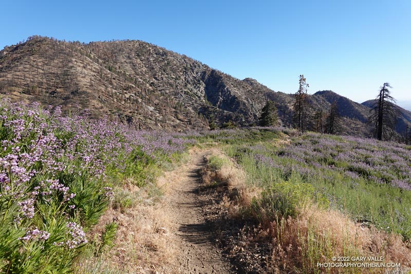
The Topanga Lookout Ridge loop is about 8.5 miles long with 2000′ of gain/loss. There are a few short climbing segments on the crest of the ridge that can be accessed from the  use trail.

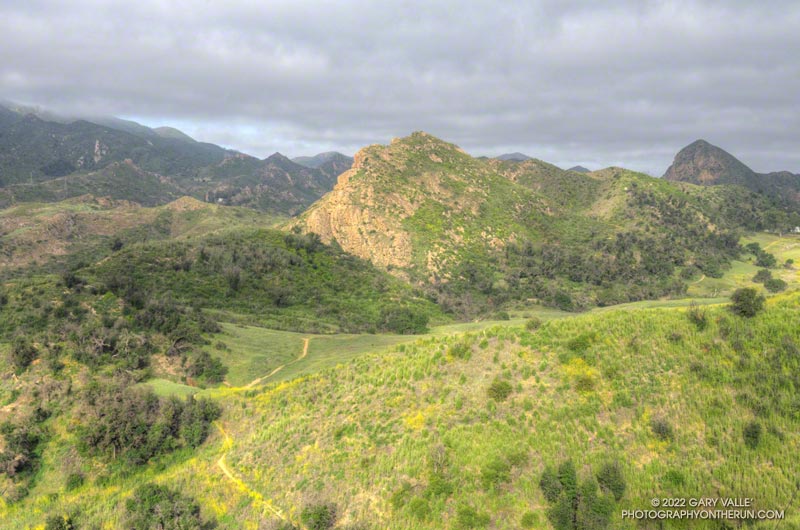
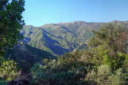
The basic loop up the Western Ridge of Boney Mountain and over Tri Peaks to the Backbone Trail and back to Wendy Drive is about 15.5 miles long with 3400′ of gain/loss. It is longer and more difficult than  the Topanga Lookout Ridge loop.

The loop over the top of Strawberry Peak from the Colby Canyon Trailhead is about 12 miles long with 3100′ of gain/loss. There is some class 2/3 climbing on the west side of Strawberry, and it is essential to stay on route. There have been a number of rescues of those attempting to climb the peak.

View along the top of Boney Mountain's western escarpment.
View along the top of Boney Mountain’s western escarpment.

It was a few minutes past six when I pushed the start button on my Garmin and jogged down the hill from the trailhead at Wendy Drive. I’d run about a half-mile when I heard another runner behind me. We chatted for a couple minutes and I learned he was preparing to do the Wonderland Trail around Rainier and then the Bear 100.

We were both going to the same area, but by different routes. I was climbing Boney Mountain’s Western Ridge and then working over to the Backbone Trail. He was doing an out and back to Sandstone Peak via Upper Sycamore, Sycamore Canyon, and the Backbone Trail. We would run into each other again at the Danielson Multi-Use Area on the way back to Wendy Drive.

Morning shadows on Boney Mountain's western escarpment
Morning shadows on Boney Mountain’s western escarpment

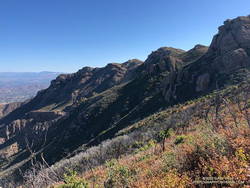
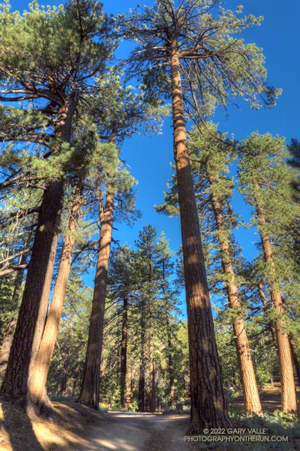
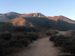
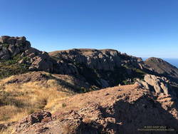
As always, the climb up the Western Ridge (Mountaineer’s Route) was enjoyable. The rock climber in me always wants to check out potential lines, but this morning there wasn’t much time for that. The longer it took to get up Boney, the hotter it was going to be later in the run!

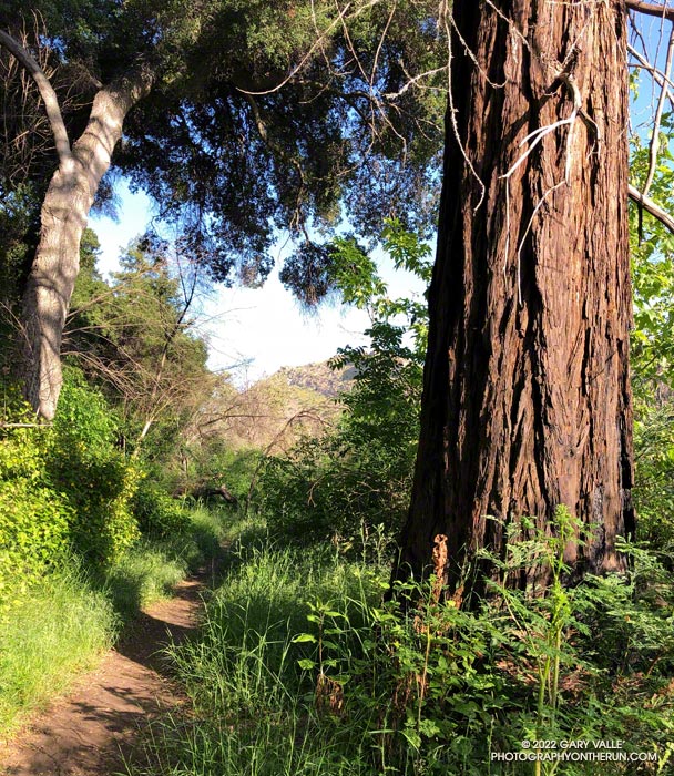
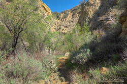
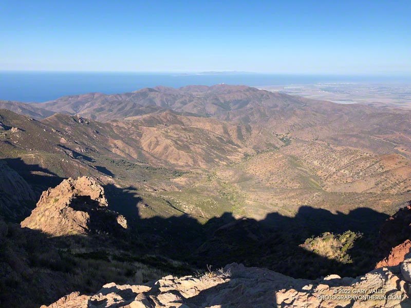
The temperature was already in the eighties when I reached the Backbone Trail. Before the fires and floods of past decade,  the run down the Chamberlain segment of the Backbone Trail was one of the better running descents in the Santa Monica Mountains. From the Tri Peaks Trail junction to the Old Boney Trail it drops about 1500′ over three miles. Today, except for the stretch of trail near Chamberlain Rock, it was nearly back to its original form.

Holly-leaved cherries along the Chamberlain segment of the Backbone Trail

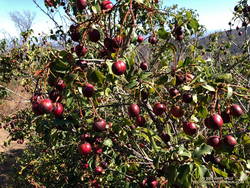
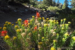
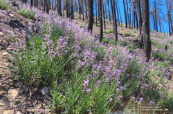
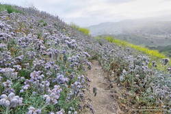
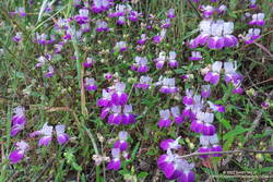
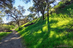
As in other areas of the Santa Monica Mountains, the effect of the heavy December rains was evident. The red shanks, and chaparral in general, seemed to be greener. This year there is a bumper crop of holly-leaved cherries, which must make the coyotes happy. Unlike last year, it looks like there should be some Christmas berries this Winter, since a number of Toyon were covered in green berries.

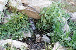
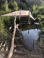
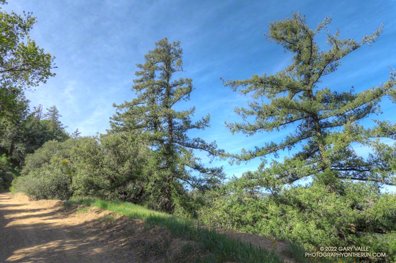
On the way down the Chamberlain Trail I started to fret that the water at Danielson might not be turned on. The water faucets in Sycamore Canyon are usually dependable, but on a run a few years ago the water system was turned off for servicing. Or what if there had been a drought-related water supply issue?

It turned out the water was still on, and I drank a lot of it. The remainder of the run went well, although I was a little surprised that the sensor on my pack recorded temps in the nineties in Sycamore Canyon. I had expected the south-facing stretch on Danielson road to be torrid, but a nice breeze kept the temperature tolerable.

Some related posts: Looking for Boney Mountain, Looking for Boney Bluff, Orange Sun Rising – A Boney Mountain Adventure Run

Thirsty Mt. Pinos

Towering pines on Mt. Pinos, near the Chula Vista parking area.

A couple leaving the camp saw that I was trying to collect drips of water from the nearly dry spring. I told them I was OK, and had water in my pack — I was just using a makeshift cup to get a couple of mouthfuls of cool water from the slowly dripping spring.

I had stopped at Sheep Camp (8300′) in the Chumash Wilderness, in Los Padres National Forest. The day was warm and the spring at the camp is usually a refreshing stop on the way back to Mt. Pinos and the trailhead at the Chula Vista parking area. Earlier, I’d talked to a runner training for the Kodiak 100, and he’d mentioned that the spring was a key source of water for his dog.

Trying to collect a mouthful of water from the spring at Sheep Camp. July 2022.
Trying to collect a mouthful of water from the spring at Sheep Camp

In recent years water has sometimes been an issue at the Sheep Camp spring. In July 2018, six out of the past seven Rain Years had been dry, and the flow of the spring was just a trickle. But it had been enough to slowly refill my Camelbak (TM) and get me down to Lily Camp (6600′) and back. Not so today.

Even without the water, Sheep Camp is a pleasant and worthwhile detour. Old growth pines tower above and bright yellow sneezeweed and other flowers are sprinkled about the forest floor. In the Spring large patches of iris bloom in the damp areas.

Today, I was returning from Mt. Abel, after having done Mt. Pinos, Sawmill Mountain, and Grouse Mountain on the way to Mt. Abel from the Chula Vista parking area. Here is an elevation profile of the run/hike. The cumulative elevation gain on the 15.5 mile run is about 3700′.

North summit of Grouse Mountain, west of Mt. Pinos.
North summit of Grouse Mountain.

The short side trips to the summits of Mt. Pinos and Sawmill require almost no extra effort, and the view from Sawmill — if it’s not too smoky or hazy — is wide-ranging. Getting to the twin summits of Grouse takes a bit more work, but it’s fun to follow the short use trail up the south summit and then to wander through the pines to the slightly taller north summit.

The descent that follows — down the use trail from Grouse and then down the Vincent Tumamait Trail to Puerto del Suelo, drops about 1000′ in elevation over 1.6 miles. This, of course, must be repaid on the way back!

When you reach the road at the end of the Vincent Tumamait Trail, you might remark, “But there’s no trail to Abel!” And you would be correct. It’s fairly straightforward to trek up through the forest from the road, though care is required due to the debris from forestry work in the area.

Rabbitbrush and paintbrush along the Vincent Tumamait Trail, northwest of Mt. Pinos.

Here’s an interactive, 3D terrain view of the run/hike from Mt. Pinos to Mt. Abel, with side trips to Sawmill Mountain, Grouse Mountain and Sheep Camp. The map can be zoomed, tilted, rotated, and panned. To change the view, use the control on the upper right side of the screen. Track and placename locations are approximate and subject to errors. Poor weather, snow, ice, and other conditions may make this route unsuitable for this activity.

More photos and info can be found in the related posts and in this post from a 2019 run/hike of this route.

Some related posts: Mt. Pinos Adventure Run to Mesa Spring; Up, Down and Around on Mt. Pinos’ Tumamait and North Fork Trails; Thunderstorm

Poodle-dog Bush Along the PCT Near Islip Saddle

Poodle-dog Bush along the Pacific Crest Trail near Islip Saddle with Mt. Williamson in the background.

Nope, my eyes weren’t deceiving me, the hiker was carrying his full-size poodle up the trail.

I was running down the PCT, east of Islip Saddle, after a run/hike to Mt. Hawkins and Throop Peak. I’m guessing the hiker was carrying his dog to keep it out of the Poodle-dog Bush on both sides of the trail.

Poodle-dog bush along the PCT above Islip Saddle in the San Gabriel Mountain
Poodle-dog bush along the PCT above Islip Saddle

Poodle-dog Bush (Eriodictyon parryi) is a fire-follower that can cause severe dermatitis in some people. In this case the plants sprouted following the 2020 Bobcat Fire.

The last big outbreak of Poodle-dog Bush followed the 2009 Station Fire. At that time many people were unfamiliar with its potential effects, and were caught off-guard.

The plant can get you in a couple of ways — the plant’s resin can affect sensitized people in a manner similar to poison oak, and the plant’s numerous hairs can break off and irritate the skin.

My experience with Poodle-dog Bush is described in the posts Contact Dermatitis from Eriodictyon parryi – Poodle-dog Bush and Getting Over Poodle-dog Bush Dermatitis.

Additional related posts: Trail Runners Describe Reactions to Poodle-dog Bush, Poodle-dog Bush Near the Top of the Mt. Wilson Trail

Forest Run

Coast redwood along the Forest Trail in Malibu Creek State Park

The nasal bellowing of a bullfrog shook the morning, but didn’t disturb the mirror-like surface of Century Lake. I had paused along the Forest Trail in Malibu Creek State Park to take in my surroundings. Here and there glimmers of sunlight reflected from the base of the reeds along the opposite shore. Birds called, flowers bloomed and Nature continued to work in its wonderous way.

Canyon sunflower along the Lookout Trail in Malibu Creek State Park.
Canyon sunflower along the Lookout Trail.

My run had started at the Cistern Trailhead on Mulholland Highway and then wandered about the Reagan Ranch area. The Lookout and Yearling Trails had been thick with mustard and badly overgrown. The plants had been wet with dew, and my black sleeves and shorts had been liberally sprinkled with the bright yellow flowers. A few ticks had also hitched a ride, but were removed before they could bite.

It had been a relief to get back to the Cage Creek Trail and descend to the Crags Road Trail and Malibu Creek. The logs extending across the creek from the washed out bridge had been rearranged, making it easier to cross.

Log crossing across Malibu Creek on the Crags Road Trail, near the Forest Trail junction.

No other trail in the Park is quite like the Forest Trail. The trail isn’t part of a loop, doesn’t connect to other trails, and is only a half-mile long; but it feels like a trail you might find in Big Sur, Santa Cruz or the Bay Area. The forest is comprised primarily of coast live oak, California bay, and sycamore, but at several spots along the trail you’ll find coast redwoods.

Coast redwoods are not endemic to Southern California. All but one of the Forest Trail redwoods were planted over 100 years ago. The trees were severely impacted by the 2011-2015 drought, and only a few have survived. Even so, they are easy to spot — the large, deeply-furrowed, copper-brown trunk of a coast redwood is unmistakable.

Note: There is some poison oak along the Forest Trail, and this year some was protruding onto the trail.

Some related posts: The Malibu Creek State Park Redwoods Are Dying; Malibu Creek State Park Redwoods: Fighting the Drought; After the Woolsey Fire: Malibu Creek State Park Redwoods, M*A*S*H Site and Bulldog Climb

Dawn Songs, Wildflowers, and a Rocket Launch from the Phantom Trail

Sun and clouds in Malibu Creek State Park
Clouds & sun at Malibu Creek State Park, near the end of the Phantom Loop

I checked my watch — it was 6:13 a.m. I was part way up the Phantom Trail in Malibu Creek State Park, and had stopped to see if I could hear the launch of the Falcon 9 at Vandenberg Space Force Base.

I’d hoped to see the launch, but low clouds obscured the view skyward. Even so, there was a chance that a thin spot in the cloud deck might reveal the ship, as it propelled its classified payload into orbit.

All was quiet, except for the dawn songs of waking birds and the occasional car or motorcycle on Mulholland Highway. But then, just above the ambient sounds, I heard it — a constant dull roar somewhere to the west. I scanned the sky for any hint of an exhaust plume.

None was evident, but I suspect that if I had looked at the right spot at the right time, I might have glimpsed the rocket’s sun-bright flame. After searching and listening for a couple of minutes, I resumed working up the trail.

Phacelia along the Phantom Trail in Malibu Creek State Park
A sea of Phacelia along the Phantom Trail

Ka-boom! Even though my attention had turned to the trail, the distinctive, two-syllable report of a sonic boom broke my reverie. It had to be the Falcon 9 booster returning to the launch site. The boom wasn’t very loud at my location, but some living closer to Vandenberg apparently mistook the launch and sonic boom as an earthquake.

The remainder of the run went well. I’d run the Ahmanson 12K the day before, and the Phantom Loop (clockwise) was a good follow-up to that run.

I was a bit surprised just how overgrown some sections of the trail were. Mustard wasn’t the only plant crowding the trail, phacelia was as thick along the Phantom Trail as I’ve seen.

A showy patch of Chinese houses wildflowers along the Phantom Trail
Chinese houses along the Phantom Trail

With the cloudy, cool start to the day, the poppies were mostly closed, but several other species of wildflowers added color along the trail. Among them were Elegant Clarkia, Owl’s Clover and Chinese Houses.

Note: A little higher in the Santa Monica Mountains and farther to the west, Jonathan Stewart captured this video of the NROL-85 launch from Boney Mountain.

Some related posts: Phantom Trail: Trade-offs of a Wet Rainy Season; Redwoods, Raptors, and the Phantom Loop; Ladyface Via the Phantom Trail and Heartbreak Ridge

Exploring the Santa Clarita Ultra & Trail Runs 50K Course

Bigcone Douglas-fir along East Canyon Mtwy fire road
Bigcone Douglas-fir along East Canyon Mtwy fire road.

I hadn’t seen a hiker, runner, or mountain biker since turning off East Canyon Mtwy fire road. That was about 2 miles ago. I checked my watch — it read 18 miles. Had I’d made a wrong turn?

Today’s plan was to do the first 25 miles of the Santa Clarita Ultra & Trail Runs 50K. A week ago I’d run the first (blue) and third (yellow) sections of the course, and today’s run would theoretically combine the first (blue) and second (orange) sections.

Oat Mountain (3747'), the highest peak in the Santa Susana Mountains.
Oat Mountain from the Towsley Canyon Loop Trail

So far, the run had gone well. It had started with an extended version of the popular Towsley Canyon Loop in Ed Tavis Park. After climbing up oil-rich Wiley Canyon to a view point at an elevation of about 2450′, the course descended a series of long switchbacks, and passed through a gap in Towsley Canyon known as the Narrows. A mile down the canyon from the Narrows I’d used segments of the Elder Loop and Taylor Loop trails to run over to Lyon Canyon.

Entrance to the Narrows on the Towsley Canyon Loop Trail
Entrance to the Narrows in Towsley Canyon

Following an out and back up the canyon to the top of a prominent hill, the course continued on the Taylor Loop nearly to the Old Road, eventually circling back to the parking area at Ed Davis. At the parking lot my watch read a bit over 9 miles.

After switching from a bottle to a pack, I’d run on the Old Road over to the East Canyon Trailhead. From there the course followed East Canyon and Sunshine Canyon fire roads to Mission Point. The climb up to Jones Junction gains about 1300′ in 3 miles, then it’s another 1.5 miles over to Mission Point (2771′), the high point on the course.

A very green stretch of the Taylor Loop Trail
Green along the Taylor Loop Trail.

One of the highlights of the run up East Canyon was the very healthy-looking Bigcone Douglas-firs higher on the road. Now relegated to the cooler climes of steep, north-facing mountain slopes, the species used to be far more widespread in Southern California.

On the way to Mission Point, the views of the San Fernando Valley from the crest were outstanding, and gave a perspective of the Valley I had not seen before. Apart from having to detour along fence lines bordering private property, and continuous gunfire in a section of the canyon that is near a popular gun club, the run to Mission Point was excellent.

The first of three short detours along fencelines on the way to Mission Point.
Detour around private property on the way to Mission Point.

Returning from Mission Point there was another part of the course I needed to do — an out and back on Weldon Mtwy. Which brings me back to mile 18 of today’s run. After turning off East Canyon Mtwy on what I thought was Weldon Mtwy, I had expected the fire road to loose elevation relatively quickly. But that wasn’t happening.

Instead of running down a canyon, I was running along a ridge — a long ridge. Below and to my right was what looked like a landfill. Below and to my left I could see the Old Road and Santa Clarita. They seemed a long way down.

Mission Point, Three Trees and the San Fernando Valley.

There were several ways I could have checked where I was — my watch has maps; my phone had maps; and I had a map in my pack. But I wasn’t in trouble and was already two miles down this road — whatever it was. If I wasn’t on Weldon Mtwy, it would still be a trail I hadn’t done.

After a couple of “I’ll just go a little farther down and see what I can see” episodes, I eventually turned around and headed back up the fire road. When I got back to East Canyon Mtwy, I checked the yellow pole marking the junction of the fire roads — it was marked “WELDON.” Later, I checked my track and found I had turned around a half-mile from the Newhall Pass Trailhead. Now I know.

Overall, I’d enjoyed the course, and decided I would register for the 50K. But registration closed early, and now I see the event has been postponed until November. Oh well, I still got to run in a new area and check out some interesting trails!