Category Archives: photography

Blame it on Cristina

View of Bench, Matlock and Slim Lakes from the north face of University Peak.

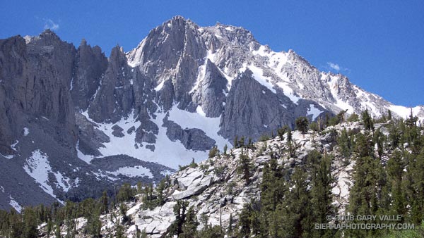
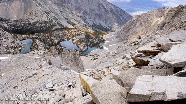
We were making good progress up the gargantuan north face of University Peak (13,632′), climbing carefully and doing our best not to knock loose rocks down on each other’s heads. We were also doing our best to ignore the gathering clouds — and the unnerving rumble of distant thunder.

Yes, it would have been better to sleep at the trailhead and get an early start. Especially with a 20% chance of isolated thunderstorms in the forecast. But we didn’t. When we should have been taking our first steps on the Kearsarge Pass trail we were eating breakfast burritos in Mojave. So it goes.

Now we were about half way up the 2200′ class 2-3 face, and it would take another hour of climbing to reach the summit. That would put us on the summit right around the time of maximum daytime heating — a bad time to top out if you’re trying to avoid a thunderstorm.

Off to the northwest there was another long, rolling, rumble of thunder. Streamers of rain could be seen twining from darkening clouds. Smoke from one or more of California’s many fires hung in the valleys to the west of the crest, producing an unnatural and eerie mixture of clouds, smoke, rain, and orange tinted terrain.

We paused in a jumble of broken blocks of granite, hemming and hawing, and otherwise hesitating to make THE decision to descend. Avoiding the issue and pondering the sky, we wondered which fire the smoke was coming from, and — half in jest — whether the smoke could have seeded and enhanced the thunderstorm we were watching. Those questions, it turns out, had surprising answers.

I had assumed the smoke was from one of the fires to the west. But this NRL Aqua-MODIS True Color satellite photo from 1:38 in the afternoon reveals the source of the smoke — it was from the Piute Fire between Lake Isabella and Tehachapi. The long plume of smoke from this fire feeds almost directly north into the large thunderstorm cluster near 37N and -118.5W.

From our vantage point on University Peak, the southern margin of this activity appeared to be about 6 miles away, somewhere near Gardiner Basin. This experimental NRL image shows the convection more clearly. Could this smoke plume have enhanced the storms over the Sierra?

The research article “Smoking Rain Clouds over the Amazon” by M. O. Andreae, et al, published in Science Magazine in 2004, and related research, suggests the possibility. According to that article, vegetation burning produces high concentrations of aerosols which are capable of nucleating cloud droplets. But, convective clouds forming in smoky air show substantially reduced droplet size compared to similar clouds in clean air. The reduced droplet size can delay the onset of precipitation, which in turn can result in enhanced convection.

So why blame the thunderstorm on Cristina? This NRL water vapor satellite photo from 3:30 p.m. suggests that the source of the moisture for the Sierra thunderstorms was Tropical Storm Cristina. An upper level low spinning off the coast had drawn the moisture up from the tropics and into the Sierra.

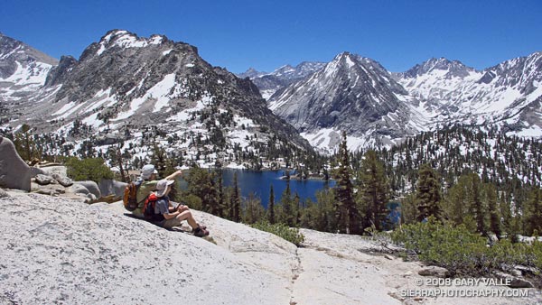
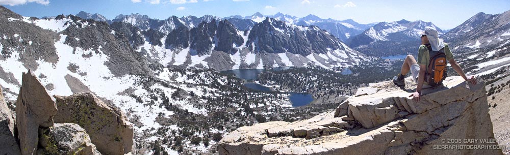
Related post: Thunderstorm, Shadow and Sun on University Peak (The north face is highlighted by the sun.)

Up and Over Kearsarge Pass

Miklos and Krisztina above Bullfrog Lake. East Vidette is the prominent conic peak.

Poised on a glacial bench a dozen miles west, and few thousand feet above Independence, California, Onion Valley is the starting point for many a Sierra adventure. Kearsarge Pass provides relatively quick and easy access to the heart of the Sierra, and the more technical passes south and north of Kearsarge can be used by mountaineers to access peaks along the crest, or basins on the west side of the crest.

It is an area that is dramatically alpine, and I have returned again and again to climb peaks such as Independence Peak and University Peak and to hike, run and explore. One Summer Phil Warrender and I did a trans-Sierra hike that started here and took us over University Pass, Andy’s Foot Pass (13,600′), Milly’s Foot Pass, Longley Pass and Sphinx Pass, ending at Cedar Grove. We went superlight (about 15 lb. packs w/o ice axe), did as much cross-county as possible, and climbed a few peaks along the way.

Today Miklos, Krisztina and I were doing a reconnaissance hike/run up and over Kearsarge Pass, and down into the Kearsarge – Bullfrog – Charlotte Lakes basin, and back. The idea was to pick a time when the Kearsarge Pass trail would be mostly free of snow, but when much of the surrounding terrain would still be accented in white.


View west from Kearsarge Pass

What a day! Perfect temps, little wind, excellent trail conditions, super scenery, and absolutely outstanding trail running.

Here are a few photographs:

Big Pothole Lake from the east side of Kearsarge Pass. Nameless Pyramid (right) and University Peak (left) on the skyline.

View west from Kearsarge Pass over Kearsarge Lakes and Pinnacles to Mt. Brewer (left), North Guard (middle) and Mt. Francis Farquhar (right) on the skyline.

Kearsarge Lakes and Pinnacles from the north.

Miklos and Krisztina above Bullfrog Lake. East Vidette is the prominent conic peak. Deerhorn Mountain is at the head of the recess to the right of East Vidette.

Scrambling above the John Muir Trail about a mile from Glen Pass. Charlotte Dome is in the distance.

Here’s a Google Earth image and a Google Earth KMZ file of a GPS trace of our route.

Stuck in the Drive-Thru

Gopher snake (apparently) stuck in the one inch diameter entrance to a small burrow on Upper Las Virgenes Canyon Trail.

Was that a snake on the trail ahead?

It was a snake — a pretty big one — stretched across two-thirds of the road.

I slow, stop running, and then walk carefully toward it. The snake is dead still. A confounding series of thoughts follow in quick succession.

Looks like it’s probably a gopher snake… Glance at the tail — no rattles. Check the head — where’s the head? Check the tail again — definitely no rattles. It is a gopher snake. Look for the head again — did the snake get run over, or decapitated?

At least 30 seconds have passed and the snake has not moved — not a millimeter. Very weird. Is it dead? It doesn’t look dead. There’s no blood.

Realization dawns as I comprehend the snake may be caught in the entrance to a small burrow.

Com’on, stuck? If so, it’s in a bad place. Pick your peril: Upper Las Virgenes Canyon is hiked, biked, ridden on horseback, roamed by coyotes, and hunted by hawks.

Now it’s been a couple of minutes, and the snake still has not moved. I’m beginning to think maybe it is dead. So I touch it.

Panic! The snake writhes, contorts and convulses in an attempt to free itself. No go — it continues to convulse, and then suddenly, and impossibly, slithers down the hole.

What? My guess is that the snake had found a lizard, mouse, or other prey in the hole, started to swallow it, and with its body engorged, became trapped by its meal. Or maybe it just got stuck!

Cheeseboro Canyon Prickly Poppy

Prickly poppy (Argemone munita) in upper Cheeseboro Canyon.

Prickly poppy (Argemone munita) in upper Cheeseboro Canyon.

From today’s run of the Cheeseboro Canyon keyhole loop, starting from the Victory trailhead of Upper Las Virgenes Canyon Open Space Preserve (formerly Ahmanson Ranch).

Here’s a Google Earth image of a GPS trace of the loop, and links to trail maps for Upper Las Virgenes Canyon Open Space Preserve and Cheeseboro/Palo Comado Canyons.