Category Archives: photography

Rainy Days on Rocky Peak Road

Stormy view of Simi Valley, California, from Rocky Peak Road.

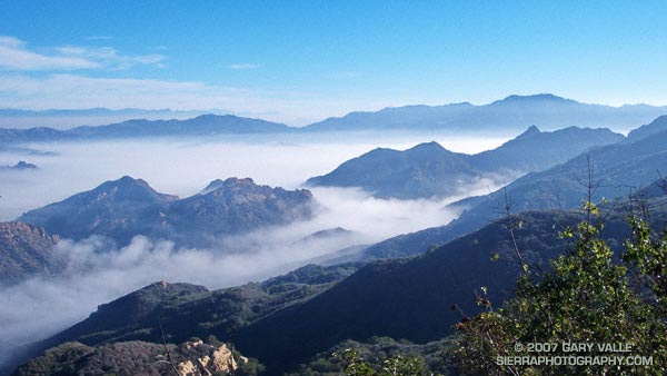
Ran Rocky Peak road both days last weekend. Saturday’s outing was a 7.3 mile rainy day run out to the Chumash Trail junction and back. Sunday’s was a little longer, about 9.3 miles — past the Chumash Trail junction to the highpoint on the road sometimes referred to as “the fossils.”

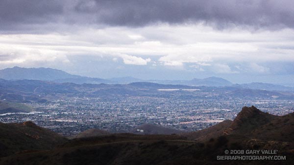
The photograph of Simi Valley was taken on Sunday afternoon, just after turning around to head back. The wind was blowing in fitful gusts, and a gray wall of rain loomed to the west. It wasn’t raining yet, but the trailhead at Santa Susana Pass was about 50 minutes away, and there was a feeling things were going to get very wet, very soon.

Over the weekend the west coast was slammed by a series of storms that increased the water year rainfall total at Downtown Los Angeles to an inch above normal and the Sierra snow pack from 60% of normal to over 100%.

So far this rain season, Southern California has dodged a La Nina bullet. This AHPS Precipitation Analysis for the water year indicates much of the area has received near normal to above normal precipitation.

Will Southern California rainfall remain near normal? The Climate Prediction Center’s precipitation outlook for Jan-Feb-Mar (issued Dec. 20), the ERSL/PSD Nov-Mar La Nina precipitation composite, and most other longer range forecast tools say no.

On the other hand… the base state of the atmospheric circulation remains more or less what it has been the past several months, so it doesn’t seem unreasonable to suggest that our pattern of near normal rainfall might continue.

The current NWS 6-10 day and 8-14 day precipitation outlooks project below normal for Southern California, but there are some hints that a system with a lower latitude track could affect the area near the end of the 14 day period. We’ll see!

Note: The ESRL/PSD Composite ENSO plots page was updated yesterday to correct an issue that resulted in the wrong set of years being used for its Winter La Nina composites. As a result the La Nina composite precipitation map in this post is drier in coastal Southern California than in the map originally published in the post Southern California 2007-2008 Winter Precipitation Outlook.

Bulldog Loop and the Corral Fire

Fog shrouded sycamores along Malibu Creek in Malibu Creek State Park.

Quiet and cold, the fog enveloped the sycamore trees along the creek and wrapped my thoughts and footfalls in a chilling shroud. I had just started the Bulldog loop and was running along a frosty road in Tapia Park. Suddenly there was a rustle and a blur of brown. Two deer darted in opposite directions. One ran toward the creek, stopping about 50 yards away. The other crossed the road in front of me, stopped at its margin, and from a distance of about 15 feet, calmly watched me run past.

I followed the dirt road another quarter-mile to the start of the Tapia Spur Trail and worked up the trail to a plastic bottle-littered pass. Along the way, I’d picked up an empty snack bag, and a couple of soda cans. Improvised trash bag overflowing, I headed down into Malibu Creek State Park.

Except for a short detour around Malibu Gorge and Century Lake, the route along Crags Road follows the meandering course of Malibu Creek. Near the M*A*S*H site, the sky began to lighten, and on the Bulldog grade, I climbed out of the fog and into a dazzling Winter sun.

Curling clouds clung to the hillside as if trying to pull the sunlit carpet of chaparral down into the gloom. Warmed by the sun, I continued the long climb to the Bulldog – Castro Crest “T.” This intersection is at about mile 8 on the 14 mile loop.

It was not until I was descending the fire road near the top of Corral Canyon that the first scars of the Corral Fire could be seen. Originating in this area, the November 2007 fire destroyed 53 homes and consumed 4901 acres.

The first burned area directly on the Bulldog route was in the rocks east of Corral Canyon Rd., at about mile 9.25. From here to about mile 12, near the junction of the Tapia and Mesa Peak motorways, the fire was generally limited to the area south of the Mesa Peak Motorway. However, it did cross the road at a few points.

Where the loop begins its descent to Malibu Canyon (by the water tank), the single track trail had been bulldozed to restore a section of fire road destroyed years ago by a landslide. After stopping for a moment at the bottom of the new road to chat with a hiker, I turned left onto Tapia Motorway and began the two mile descent back to the car.

Here is a Google Earth image and a Google Earth KMZ file of a GPS trace of the Bulldog Loop, with the 11-27-07 GEOMAC Corral Fire perimeter added.

Note: Mileages are approximate and measured by GPS from the intersection of Piuma Rd. and Malibu Canyon Rd.

Related posts: Backbone, Bulldog & Beyond, Rock Formations Along the Backbone Trail

Laguna Peak, La Jolla Valley, and the Channel Islands

Laguna Peak, La Jolla Valley, and the Channel Islands (Anacapa and Santa Cruz) from Boney Mountain.

Wow, it was windy! I was on an exposed ridge between Tri-Peaks and Big Dome, getting pushed around by a unrelenting offshore wind, trying to keep my footing, and take a few photos. About the time I was traversing the ridge, Laguna Peak — the peak in the photograph with all the communications equipment on its summit– recorded a gust of 67 mph.

But this is a mere breeze by Laguna Peak standards. A communication facility operated by the U.S. Navy, the weather station has recorded hurricane force winds on numerous occasions. Several of the wind events listed in the NWS document A History of Significant Weather Events in Southern California reference Laguna Peak. In March of 1991 a gust of 125 mph was recorded at the peak.

Update 12/25/07. Merry Christmas! This morning, about 6:15, Laguna Peak recorded a wind gust of 91.8 mph and several gusts in excess of 85 mph. Between 10:00 a.m. and 11:30 a.m. several gusts over 90 mph were recorded, including one measured at 91.9 mph.

La Jolla Valley is the small valley just below Laguna Peak. Isolated and scenic, it is a “must do” hike or run that can be accessed from the Ray Miller trailhead on PCH, or from Big Sycamore Canyon.

The peak on the left in this wider 16:9 format view is Mugu Peak. Its summit overlooks Pt. Mugu and is a relatively short side trip from the Mugu Trail.

Offshore, two of the Channel Islands can be seen — Anacapa (left) and Santa Cruz.

Chumash View II

View northwest to the Ventura Mountains from the Chumash Trail.

View northwest to the Ventura Mountains from the Chumash Trail. The highest peak on the skyline is Hines Peak (6716′), about 28 miles distant. Here’s a larger version of the 16:9 format image. Note the hawk soaring high above the terrain.

I run the Chumash Trail frequently, but had not seen the bulldozed track on the steep slope near the start of the trail. The trail hasn’t been re-routed. Apparently on the 13th a 4WD truck that was part of a fire department response to a cycling accident got stuck, and a bulldozer was called in to extricate the vehicle. I’ve been told the Park District and Mountains Conservancy are considering next steps.