Category Archives: photography|trail running

Running Rocky Peak Road

Stretch of Rocky Peak Road about 1.5 miles from the trailhead at the 118 freeway.

I was surprised how good my legs felt on the steeps on Rocky Peak. Apparently skiing San Jacinto was a great way to knock my legs out of the doldrums — and make them happy to be using shoes that weigh only 22 ounces/pair!

This stretch of Rocky Peak Road is about 1.5 miles from the trailhead at the 118 freeway. It is also about 2.7 miles into the Bandit 30K and 14K courses.

Related posts: Bandit 30K Course Preview, Rainy Morning on Rocky Peak Road

Garapito Trail Green

Garapito Trail in Topanga State Park.

Not the green of shamrocks or jade, or an emerald sea,
but of new growth along a trail, softly seen
.

From a run of the Trailer Canyon – Trippet Ranch loop, described in Garapito Trail Runs.

Here is a Live Browser View of the run.

Related post: Ferns Along the Garapito Trail

Blue Skies and Short Sleeves on Strawberry Peak

Mt. Baldy from near the summit of Strawberry Peak, in the San Gabriel Mountains.

My legs were still pretty worked from the Boney Mountain Half Marathon. Instead of backing off of the pace on my weekday workouts, I had continued to experiment with a change in running technique that was resulting in faster paced runs. I was excited about the increase in speed, but logging fast times on oft-run courses after a strenuous race doesn’t equal recovery. Neither does blasting up a peak in the San Gabriel Mountains.

But it was one of those impossible to ignore, blue sky, short-sleeved Southern California Winter weekends. This would be an unprecedented eighth straight January day that the high temperature in Los Angeles exceeded eighty degrees. In the yin yang of weather, the western half of the U.S. has been enjoying unusually warm temps, while the eastern half of the country shivered.

Taking maximum advantage of the good weather, yesterday I had done a little kayaking on the Kern River, this morning some rock climbing at Stoney Point, and now we were huffing and puffing up Strawberry Peak (6164′) — and doing it “for time.”

We had started at Red Box, the shortest and technically most moderate way to climb the peak. By this route it’s about 3.4 miles to the summit, with an elevation gain of roughly 1600 ft. About two-thirds of that distance is well-graded trail, the rest is steep use trail up a broad, brush covered ridge.

About halfway between Lawlor Saddle and the summit of Strawberry it became plainly and painfully evident that my legs had given their all. I complain. Miklos — always sympathetic — asks why I can’t go any faster.

On the final steep push to the summit ridge I try a different tactic to slow the pace, and tell a story about an unbelievably angry and aggressive raccoon I once encountered near here. But like President Jimmy Carter’s rabbit incident, it loses something in the telling. Redlined, we crest the summit ridge and sprint (relatively speaking) toward the summit.

On the summit, there is not a breath of wind. The view is exceptional. To the southwest, sunlight gleams on the waters of the Pacific near Palos Verdes, and to the west snow gleams white on Mt. Baldy. Some 90 miles distant, near Palm Springs, is the asymmetric silhouette of Mt. San Jacinto.

Soon we’re headed down. As I drop below the summit ridge, a snowball whizzes past my ear, crashing on the trail ahead. It has been warm and dry for weeks, but remarkably, there are a few patches of snow. It is a reminder that Winter is not over, and like the snow, is lurking in the shadows.

Serrano Valley from Wendy Drive

Descending to Serrano Valley in Pt. Mugu State Park

Scruffy clouds clung to the mountain ridges and summits, confirmation that a weak cold front was moving through the area, cooling temperatures and stirring up the wind. The forecast for the Santa Monica Mountains National Recreation Area had mentioned 25 to 35 mph winds with gusts to 60 mph. So far the weather in Pt. Mugu State Park had been nearly perfect — breezy and little chilly, but without the impenetrable winds that can take all the joy out of running.

Earlier we had climbed the Fossil Trail, a steep mile-long trail that connects the Upper Sycamore Trail, near its junction with Sycamore Canyon Road, to the Old Boney Trail. With only a few weeks remaining to the Solstice, shadows in the canyon were long and the light wintery. I thought we might have missed the fossils, but we happened on a nice exposure about a tenth of a mile below the Old Boney Trail junction.

About 5.5 miles later, we turned off the Old Boney Trail and descended to the rolling grasslands of Serrano Valley, another “must see” area of the Santa Monica Mountains.

Located on the east side of Big Sycamore Canyon, Serrano Valley is a more rugged counterpart to La Jolla Valley, just three miles to the west. Overseen by the castle-like summits of Boney Mountain, its vistas have a roughhewn edge, reminiscent of the most wild areas of the western U.S.

Here is a Google Earth image and Google Earth KMZ file of a GPS trace of our approximately 19 mile route to Serrano Valley and back to Wendy Drive.

Related posts: La Jolla Valley & Mugu Peak from Wendy Drive, Fossil Trail – Pt. Mugu State Park

San Gorgonio Mountain – Falls Creek Loop

Falls Creek trail on Mt. San Gorgonio.

Lowland blues got you down? Are you beginning to think faux pine tree cell towers aren’t that ugly? Do you gaze longingly at distant mountains and then realize you’re looking at a billboard?

When I feel that way, one of the close-to-home hikes/runs that satiates the alpine craving is the Falls Creek loop on Mt. San Gorgonio. The ‘Falls Creek up, Vivian Creek down’ route has been a high mountain favorite of mine for a number of years. It is as rigorous as it is beautiful. About 24.5 miles long, it gains approximately 6600′ on the way to the 11,499′ summit of San Gorgonio.

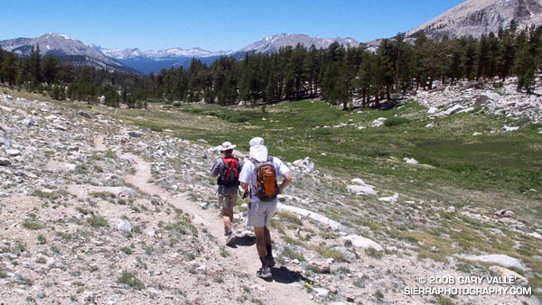
Even at 7:30 in the morning, the climb out from the Momyer trailhead on the steep, south-facing slope of Mill Creek canyon had been warm, but in about an hour we were in the firs and pines, and contouring into the shaded drainage of Alger Creek. Another 30 minutes and the trail has joined the route of the original Falls Creek trail — climbing to the eastern side of the divide between Alger Creek and Falls Creek and turning north as it entered the Falls Creek drainage. (A spur trail descends to Dobbs Camp.)


Small stream below Saxton Camp.
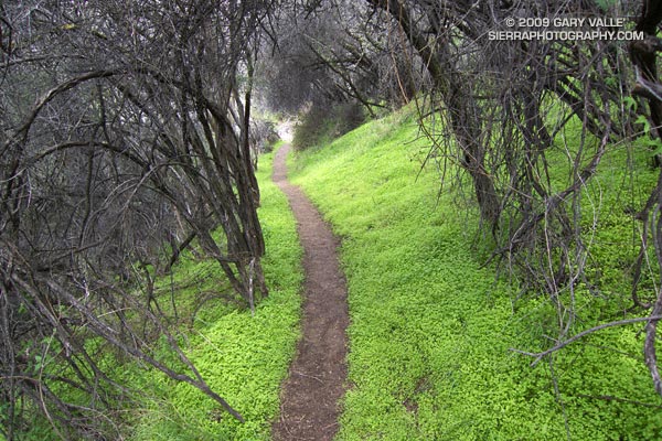
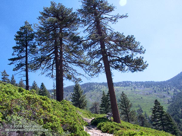
The trail up the Falls Creek drainage has few switchbacks and is deceivingly steep, but the segment is one I always enjoy. Near Saxton Camp its course works back into a lush side canyon, where it crosses an idyllic stream in a pastoral mountain setting. Above Saxton Camp, the area has an isolated, big sky, big mountain feel. Bright green slopes of manzanita extend upward for miles, and stale flatland sights, smells and sounds are displaced in favor of deep blue skies, the minty fragrance of pennyroyal, and the raucous shouts of Stellar’s jays.

Just get me to Dollar Lake Saddle… Please! I don’t know what it is about this section of trail, but the short 1000′ climb from Plummer Meadows to Dollar Lake Saddle is always tougher than I expect. Maybe it’s the altitude, maybe it’s the miles I’ve run during the week, or maybe it’s a gravity anomaly — whatever, it’s a relief to get to the saddle.


Lodgepole pine above the Jepson - Little Charlton Peak Saddle.
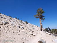
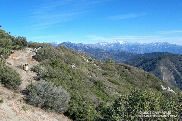
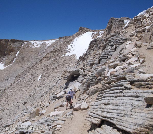
Above the saddle, the trail becomes more airy and alpine, and at times there are views of the summit area of Gorgonio and down Gorgonio’s north face. Adrenalin flows and the effort required seems to ease. Sometimes running, sometimes hiking, we continue up the rocky path.

About an hour above Dollar Lake Saddle, we jog across a nice flat stretch of trail just below Gorgonio’s summit. It’s around noon when Andrew and I weave our way through a final few boulders to the summit. Relaxing on the summit, we chat with others about their routes, and talk about running and the mountains.

In February, Andrew caught the trail running bug. In May he completed his first ultra — a fifty miler. Now he’s training to run the Angeles Crest 100 mile endurance run in September. Today’s ascent of San Gorgonio is the first of two long mountain trail runs he will do this weekend.

After about 15-20 minutes on the summit, we jog back to the Vivian Creek trail, jump on the escalator and head down. There are the usual stops to get water at Upper Vivian Creek (the last water was at Plummer Meadows), and to take a few photographs. There’s also a quick stop to have our wilderness permit checked.

Around 2:50 we’re off the mountain and crossing Mill Creek, and in a few minutes we’re running down the blacktop and back to Momyer.

Here’s a Google Earth image and Google Earth KMZ file of a GPS trace of the loop. Surprisingly, it is only about 1.5 miles shorter than the “high line” loop that ascends East San Bernardino Peak before traversing to Mt. San Gorgonio.

Related post: San Gorgonio High Line

New Army Pass – Cottonwood Pass Loop

Outstanding trail running down the Rock Creek trail on the Cottonwood loop.

It isn’t unusual for snow to persist on New Army Pass (12,300′) well into July. Strong northwest winds, following in the wake of blustery Winter storms, blow freshly fallen snow over the crest and into this cirque, forming cornices along its lip, and dense slabs of wind-ground snow in it’s lee.

That’s why the July 1 Sequoia & Kings Canyon National Park Trail Conditions report for New Army Pass seemed plausible. It read, “The top of the pass has an 30 foot snow wall – ice axe recommended.”

The reported trail conditions are a compilation of reports from the field, and are not always up-to-date. Having been over the pass a number of times, and in a variety of conditions, I thought that we would probably be able to bypass any remaining patches of snow without needing an ice axe. Worst case, if the pass looked dicey, we could use Cirque Peak or some other alternative route to attain the crest.


New Army Pass
We need not have worried. While there was snow in the cirque, and in a couple of places along the trail near the top of the pass, the trail was completely clear. Even so, it was a good excuse to do the 21 mile Cottonwood loop counterclockwise — the reverse of my usual circuit — climbing up New Army Pass from the Cottonwood Lakes side, and then running down into Rock Creek basin.

Now that I’ve done the loop in both directions, I think I prefer the clockwise circuit. The 9 miles of running from New Army Pass down through the Cottonwood Lakes basin is generally better than the running down from Chicken Spring Lake and Cottonwood Pass. Also, there’s more downhill on some sandy sections of trail between Chicken Spring Lake and Rock Creek. The tradeoff is you give up the nice downhill into Rock Creek basin, and near the end of the loop have a mile or so of annoying uphill.

Here’s a Google Earth image, Google Earth KMZ file, and an elevation profile of a GPS trace of the route. (The elevation profile was generated using SportTracks.)

Related posts: Cottonwood – New Army Pass Loop, Mt. Langley in a Day from L.A.