Parked in a turnout on Mulholland Hwy, I finished putting on sunscreen and then pushed the Start/Stop button on my watch to dial in the GPS and pair my HRM. Outside, it was a chilly 43 degrees. Sunrise was nearing and the strengthening March sun was forecast to push temps well into the 70s.
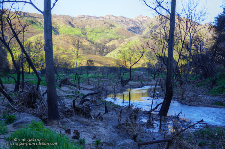
In the aftermath of Woolsey Fire, I’d returned to Malibu Creek State Park to see the wildflowers; gauge the response of the creek to heavy Winter rains; check on the health of the redwoods along the Forest Trail, and assess the ongoing recovery of the burned chaparral.
Today’s run of the Bulldog Loop would be a follow-up to two runs in the park in December 2018, which found a fire-ravaged landscape just beginning the long process of recovery.
The Ray Miller Trailhead in Pt. Mugu State Park marks the western end of the Backbone Trail, a 68-mile scenic trail along the spine of the Santa Monica Mountains. The Ray Miller Trail’s long, winding descent into La Jolla Canyon is a favorite of runners and hikers, and a fitting end to those traversing the BBT from east to west.
My run this morning was to the Ray Miller Trailhead (and back) from Satwiwa, starting at the Wendy Drive trailhead in Newbury Park. The Wendy Drive Trailhead is very popular and is the starting point for many good runs, hikes and rides. To get an idea of the route options, see the detailed trail maps on the Pt. Mugu State Park page of VenturaCountryTrails.org.
Today I was looking to do a longer run, so didn’t take the usual route. On the way down Big Sycamore Canyon, I skipped the turns at Wood Canyon (Hell Hill), Wood Canyon Vista Trail (BBT) and Fireline Trail and at Overlook Fire Road, some eight miles into the run, finally headed uphill.
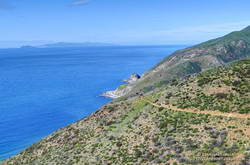
View of the Pacific, Anacapa Island and Santa Cruz Island from the Ray Miller Trail.
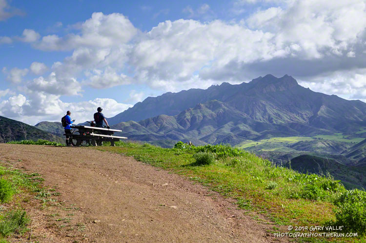
The top of the Ray Miller Trail is a stout 2.5 -mile climb from the bottom of Overlook Fire Road. Along the way there were excellent views of Sycamore Canyon, Serrano Valley and Boney Mountain.
About a half-mile down the Ray Miller Trail there is a popular overlook of the coast. The day was clear and there were stunning views of the Pacific and the Channel Islands. Brushed by whispers of wind, the cerulean blue Pacific filled my view for much of the descent to the parking lot.
It was an odd feeling to run down to the parking lot with runners who were cheerfully finishing their morning run, knowing that I had many more miles to go. After a quick stop at the water spigot, I turned, and sighed, and took the first steps back up the hill and toward Satwiwa.
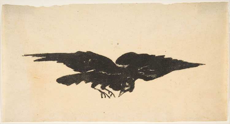
The Flying Raven, Ex Libris for The Raven by Edgar Allan Poe,1875, Édouard Manet, The Metropolitan Museum of Art.
Nearly to the top of the Beast, I was thinking how scraggly the valley oak at the top of the hill looked when my thoughts were interrupted by the cacophonous cawing of a raven perched in that tree. For the purpose of this story, let’s call him (or her) Ed.
That Ed would be in an oak tree, clamoring away, wasn’t so unusual. Ravens are loquacious birds that always seem to have something to say. As I crested the hill I mimicked his vocalizations, and in so many words, we exchanged greetings.
I ran past the oak, expecting Ed to quiet down, but the exclamations continued behind me. After a few seconds Ed flew past, toward the trailless center of Lasky Mesa — caw, cawing all the way.
I expected that would be the last I would see of Ed, and thought how unusual his behavior had been. His pronouncements were very persistent and seemed very urgent.
I continued to run on the dirt road on the south side of the mesa. As I ran, I watched Ed flying above the grass and brush about 70 yards to my left. His flying was a little erratic and he continued to caw. Crazy bird…
As I watched, Ed turned and started flying toward me. At first I thought, “Interesting.” He was some distance away and I thought surely he would turn. But he continued to fly directly at me, ranting all the way.
I stopped running. Ed had not changed course and was making a beeline for me. He was flying lower than usual, and I began to wonder if I should be concerned. Was this bird OK?
Spellbound, I watched the bird’s intentioned approach and was astonished when Ed swooped past me and deftly landed on a “Restoration Area” sign three or four feet from where I was standing.
Ravens are BIG birds, and I started to talk to this one like it was a black lab.
“What’s wrong big guy?”
“What are you trying to tell me?”
The raven watched me, repeatedly cawing, cawing, cawing. Clearly he was concerned; clearly he was trying to tell me something. I just did not understand.
In a rush of feathers, Ed took flight. He crossed the road, flew back over the brush ahead of me and to my left, and swooped low to the ground.
And that’s when the coyote burst from the brush in front of me and scurried across the road, Ed in chase.
I shook my head and grinned. Ed had been trying to tell me there was a predator nearby!
It’s common for birds and other animals to sound an alert or even pester a predator, but Ed had behaved more like a devoted dog worried about his friend.
Animals often have stories to tell, we just have to listen.
The trail work schedule of the Santa Monica Mountains Trail Council (SMMTC) is impressive to say the least. According to their Trail Work Statistics page, in 2018 the SMMTC was responsible for over 4,300 person-hours of work related to “establishing, preserving and maintaining the public trail system throughout the Santa Monica Mountains and adjacent areas.”
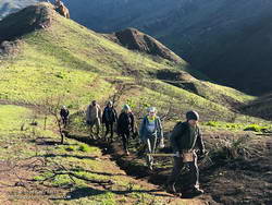
Some of the SMMTC crew approaching the junction of the Old Boney and Chamberlain Trails.
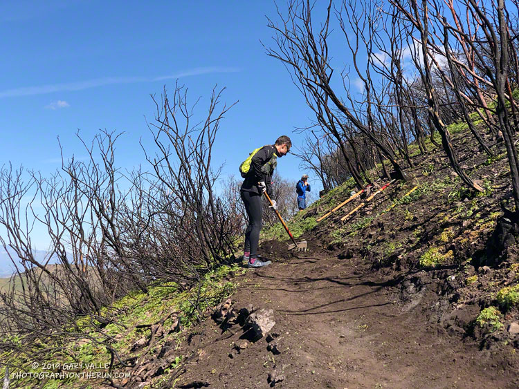
Saturday, 27 trail runners assisted the SMMTC in trail work on the Chamberlain Trail segment of the Backbone Trail. The trail runners were organized by Backbone Trail Utra race director Mike Epler, who recently joined the board of the SMMTC. Ultra race director Keira Henninger volunteered and also encouraged runners to participate.
The Chamberlain Trail took a hard hit from the Woolsey Fire and subsequent rains. Under the direction of SMMTC crew members, runners restored washed out and rutted sections of trail and removed burned limbs, rocks and other debris. The trail was restored from its junction with the Old Boney Trail up to Chamberlain Rock. In preparation for future trail work, hundreds of limbs were removed from the trail up to its junction with the Tri Peaks Trail.
Many runners ran to the Chamberlain Trail, did the trail work, and then ran back. This was a good way to get in a good long run and contribute to the restoration of the trails damaged in the Woolsey Fire.
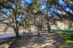
Today, Ann, Skye and I did a variation of the Bulldog Loop that starts/ends at the Cistern Trailhead on Mulholland Highway and which covers a large portion of Malibu Creek State Park.
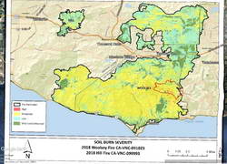
The Woolsey and Hill Fires Watershed Emergency Response Team Final Report included in-depth information concerning these fires, including detailed Values-at-Risk assessments.
Woolsey and Hill Fires WERT Soil Burn Severity Map with Bulldog Loop track added. Click for larger image.
The soil burn severity map included in that report shows that Malibu Creek State Park was one of the most severely burned areas in the Woolsey Fire. This was clearly evident as we ran/hiked along Bulldog Mtwy, Castro Peak Mtwy and Mesa Peak Mtwy. Here is a Google Earth image of the WERT Soil Burn Severity Map with a GPS track of our run added.
As mentioned in last week’s post, there had been some flooding and small debris flows along Crags Road near the M*A*S*H site and at the bottom of Bulldog Mtwy. This week we noted some rockfall along a stretch of Mesa Peak Mtwy that is prone to rockfall. Hazards existed before the fire and hazards exist after the fire.
Bulldog Mtwy and Castro Peak Mtwy had been recently graded and were in decent shape — at least as of December 29. Heavy rain may have changed that assessment.
As badly burned as the park is, there were some things to see on the plus side. The area’s vegetation was taking its first steps toward recovery, with grasses and other annuals, laurel sumac and wild cucumber sprouting. Most of the chaparral along the Mesa Peak Mtwy segment of the Backbone Trail between the picnic table at Puerco Mtwy and Tapia Park was left intact. Most of the Tapia Spur Trail was just outside the fire’s perimeter.
Large coast live oaks along Crags Road, following the Woolsey Fire. Click for a larger image
It was was also heartening to see that most of the large oaks along the High Road, west of the parking lot, were OK. Many of the oaks, sycamores, willows and other trees along Crags Road were scorched, but looked like they will recover.
I’d done a long run the day before in Pt. Mugu State Park, so the plan for this morning was to do a short run and check out the Woolsey Fire impacts between Century Lake and the M*A*S*H site in Malibu Creek State Park.
In addition to checking the condition of the coast live oaks and other native trees, I was curious to see how the coast redwoods along the Forest Trail had fared. These trees were planted nearly a century ago and in recent years have struggled with the drought. Had they survived the fire?
It had been about a year since I had checked on the redwoods. The good news is that a few of them still appear to be viable. The bottom limbs on some of the trees were scorched, but I think they will be OK. Of the 16 or so redwoods, about five have died, about five are in poor shape, and five or six appear to be OK. There is one young naturally occurring tree that was severely scorched and may not survive. We’ll just have to see.
While there was some damage to the M*A*S*H site, the picnic tables, ambulance, and signpost made it through the fire. Some repairs will be necessary.
I was supposed to turn around at the M*A*S*H site, but you know how that goes. I wanted to see “just a little” of the Bulldog climb… and a little more… and a little more. I finally ran out of time about 2.5 miles up Bulldog Mtwy and headed back.
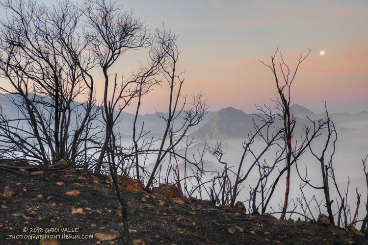
Even when you expect it, it is sobering to see areas of high soil burn severity. Thirty-six years of robust chaparral growth were just… gone. Also startling were the stream flows and debris flows that resulted from “only” about 1.5 – 2.0 inches of rainfall in early December. An atmospheric river event of the magnitude that caused the Malibu Creek flooding in February 2017 would be catastrophic.
A lot of work had been done on Bulldog Mtwy. It had been repaired and graded. Where there was still brush and trees along the road the branches had been trimmed!