Category Archives: running

Summer Returns

Poison Oak along the Blue Canyon Trail.

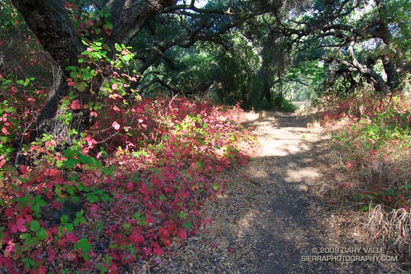
Poison Oak Along the Blue Canyon Trail.

Since nearly all my weekday runs are in the afternoon, on Summer weekends I usually like to escape the heat and do a run in the mountains — the higher, the better. But today even the mountains were going to be hot. Hot enough that the National Weather Service had issued an Excessive Heat Warning for a combination of heat and humidity that would “create a dangerous situation in which heat illnesses are likely.”

It would be cooler at the higher elevations of the Sierra, but there was good chance of thunderstorms developing along the crest of the Sierra, as well as most of the higher mountains of Southern California. Considering the options, I finally decided to do an early morning run in Pt. Mugu State Park. If I was going to run in the heat, it might as well be a scenic run close to home. Maybe the weather in the mountains would be better next weekend.


Sunrise on the Satwiwa loop trail.
There are many excellent courses at Pt. Mugu State Park. The course I was doing today is a “backward” variant of the Boney Mountain Half Marathon Course — up the Old Boney Trail, down to the Danielson Multi-use area, up Ranch Center fire road to the Hidden Pond Trail, and then back on the Upper Sycamore Trail. Water is normally available at Danielson Multi-use area and at the start of the Upper Sycamore Trail.

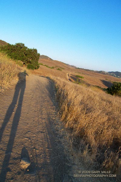
I should have started the run at dawn, but instead ambled along a section of the Satwiwa Loop trail at sunrise. The light was muted and golden, stretching my shadow well out on the trail ahead. Cool trickles of air filled each dip and gully and I wondered how long the temperate conditions would last. Ironically, the last time I had done this course it had been blustery and cold, and there had been snow on the mountains above Ventura. Not today…


Crags above the Danielson cabin site on Boney Mountain.
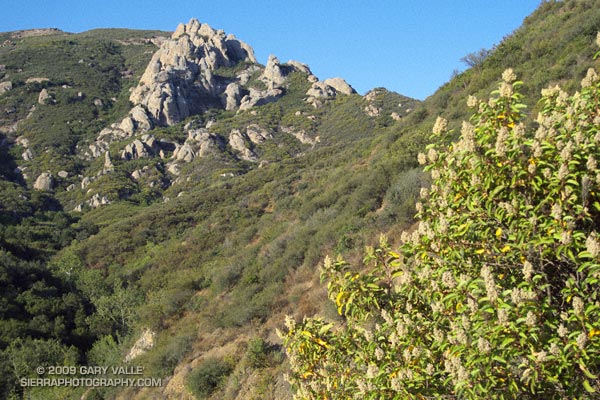
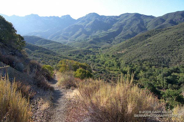
It was warm running up the east facing section of the Old Boney Trail, but not yet hot. The crags to the west of the Danielson cabin site, gleamed in the morning sun, and for a brief instant I debated climbing the ridge. The impulse passed, and once over the shoulder of Boney Mountain, I thoroughly enjoyed the (mostly) downhill running through the Boney Mountain Wilderness to the Blue Canyon Trail junction. Cool air draining from the shaded slopes of Boney Mountain kept temps reasonable in the canyon, and the running was good all the way to the Danielson Multi-use area.


Descending to the Old Boney and Blue Canyon trail junction.
At the Multi-use area there is a choice. The coolest and most direct route to the Upper Sycamore Trail is up shaded (and paved) Sycamore Canyon road. But with the Mt Disappointment race looming, I wanted to get in more time and elevation gain, so opted for the longer, more exposed route up the Ranch Center fire road, and then along the ridge on the Hidden Pond Trail. Yes it was hot, and the humidity was up a bit, but it was still scenic and enjoyable in a “I’m not going to let the heat get to me” kind of way. And I knew a water faucet was waiting for me at the point where the Hidden Pond Trail rejoins Sycamore Canyon road, and the Upper Sycamore Trail continues eastward.

Maybe it was the heat, or maybe the coyote had learned to scavenge food from hikers — whatever the case the coyote ahead of me on the Upper Sycamore trail didn’t seem to be in any particular hurry to get off the trail. Coyotes are an odd sort, very intelligent and adaptable, but in my experience not normally any kind of threat.

Usually they will scurry away from a runner. This coyote wasn’t scurrying anywhere. I picked up the pace and clapped my hands, and eventually the animal grudgingly took cover to the side of the trail. But, as it turns out, only about 4 feet off the trail. This was odd, brazen behavior, and I kept a wary eye as I passed.

The final challenge of the morning was the hot climb up to Satwiwa on the Danielson road from the end of the Upper Sycamore Trail. The hill isn’t long or particularly steep, but it faces directly into the sun. With the heat of the day building, it wasn’t easy.

Overall it was an excellent run that would have been even better with an earlier start. Here’s a Cesium browser View of a GPS trace of the approximately 14.5 mile route.

Related post: Big Sycamore Canyon Circuit

Montrail Mountain Masochist

Montrail Mountain Masochist

Last updated 08/05/09.

The trail shoes I’ve been running in the most over the last several months are the Salomon XT Wings, Salomon SpeedComp, and the adidas Response Trail 15. I’ve been happy with the performance of these shoes, but still like to try something new from time to time.

Recently, the cushioning on one of my pairs of XT Wings died, so I thought I’d give the Montrail Mountain Masochist a try. I’ve now run about 35 miles in the Mountain Masochist, on a variety of courses, including the Mt. Pinos trail run on Sunday. Trail surfaces have ranged from smooth dirt road to very rocky, technical single track trail.

From the first mile the shoes have been comfortable, and fit my moderately high-arched, D-width foot well. At 12 oz./each (US size 9.5) are on the lighter side for a medium weight shoe.


Outsole of Montrail Mountain Masochist.
The outsole appeared to have good traction on a mix of dry surfaces without being overly aggressive and grabby. On the rocky sections of trail, the shield in the midsole did a good job of protecting against pointy rocks.

My foot likes a neutral shoe with little or no pronation control, and so far the modest amount of pronation control in the Mountain Masochist has not felt overly restrictive. (See update below.)

The shoe seems to encourage a more forward body position and foot strike, which I prefer. The forefoot cushioning is good, and the strike-to-toe transitions feel smooth. On rough trails, the shoe has been stable, and I have not noticed any abnormal tendency to roll an ankle.

Overall, the Mountain Masochist appears to be a balanced, well thought out design. I hope to get them out on a 20+ mile mountain run soon.

Update 08/05/09. I now have 81 miles on this shoe and used it on the Cottonwood – New Army Pass loop in the Sierra back in July. Overall, the shoe has performed well. I do notice the pronation control on longer runs, and would love to see a version of this shoe designed for a neutral foot.

Chumash Wilderness Trail Run

Lynn Longan running up the switchbacks near the Condor Observation Site on Mt. Pinos.

 The out and back trail run from the Chula Vista parking lot on Mt. Pinos to the top of Mt. Abel is one of the best “short” mountain runs in Southern California. Most of the run is on the Vincent Tumamait Trail —  a technical single track trail in the Chumash Wilderness in Los Padres National Forest.

Llama on the trail/road up to the Condor Observation Site and summit of Mt. Pinos.Ranging in elevation from about 7700′ to 8800′, the run packs a lot into its 15 mile length, combining great scenery with demanding uphills and superb downhills through old growth pine and fir forest. The summit area of Mt. Pinos is open and alpine with views that can range from the ocean to the Sierra.
 
Yellow monkeyflower and western blue flag (iris) at Sheep Camp.About 4 miles from the parking lot is the North Fork Trail junction. A short side trip on this trail leads to the seeps, spring and wildflowers at Sheep Camp. The Vincent Tumamait Trail ends at Cerro Noroeste (Mt. Abel) road, but it is not difficult to work up through the pines about 1/3 of a mile to the campground on Mt. Abel’s summit.

Usually about 20-30 degrees cooler than lowland hot spots such as the San Fernando Valley, the run is a great way to beat the heat on a hot summer day. See the post Vincent Tumamait Trail for more info and additional trail running options.

The title photo is of Lynn Longan, running up the switchbacks near the Condor Observation Site on Mt. Pinos.

Onion Valley – Kearsarge Pass – Glen Pass Trail Run

Mt. Cotter (center) and Mt. Clarence King (right) from Glen Pass.

Mt. Cotter and Mt. Clarence King from Glen Pass.


Nearing Glen Pass
The last time I was on Glen Pass was a brisk and brilliant October morning in the late 70’s. Overnight, the first cold front of the season had covered the trail with a few inches of snow. Working up toward the pass, bright fingers of gold had reached through long shadows to illuminate the angular, lichen-covered rocks, and the new snow had sparkled in celebration of Winter’s rapid approach.

Today, I’m back on Glen Pass, once again reveling in the wildness and beauty of my surroundings. There is almost no wind, and even at 12,000′ the day is warm. Refreshed by late season storms, the remaining snow is bright and youthful, accenting the elegant lines of the rugged alpine terrain. In counterpoint to the snow, a patchwork of clouds decorate the intensely blue sky.

In the outdoors, each place and day is remarkable in its own way.

Here are a few photographs from the run:

University Peak (13,589’/4142 m) from the Kearsarge Pass Trail.


Spectacular running at 11,000 ft near Bullfrog Lake

Spectacular running at 11,000′ near Bullfrog Lake. The snowy peaks are (l-r) South Guard, Mt. Brewer, North Guard, and Mt. Francis Farquhar.

Charlotte Dome from the PCT/John Muir Trail, south of Glen Pass.

Switchbacks on the south side of Glen Pass. If you look closely you can see a pair of hikers working up the trail.

Nearing the top of Glen Pass (11,978’/3651 m).


Charlotte Dome from the PCT/John Muir Trail
The out and back trail run from Onion Valley (9200’/2804 m), over Kearsarge Pass (11823’/3604 m), to Glen Pass (11,978’/3651 m) worked out to about 20 miles, with an elevation gain/loss of about 4750 ft. Here’s a Cesium browser View of a GPS trace of my route and an elevation profile generated in SportTracks.

Related post: Up and Over Kearsarge Pass

Where the Heart Is — and Lungs, and Stomach and…

Maybe because we’re involved in outdoor sports, we’re more aware of basic human anatomy than some other segments of the population, but I am still stupefied to read the results of a recent study in which less than one-third (31.4%) of the participants correctly identified the location of the lungs on a diagram of the human body.

The study, published in BMC Family Practice (2009, 10:43), was intended to evaluate the anatomical knowledge of different patient groups and the general public, and compare the results to a similar study done in 1970.

In the 2009 study, less than half (46.5%) of the participants correctly identified the location of the heart, and a little more than one-third (38.4%) could identify the location of the stomach.

The percentage correct for each item of the anatomy tested (heart, lungs, stomach, intestines, bladder, thyroid, liver and kidneys) averaged 51.4% in 1970 and 52.5% in the 2009 study.

Tinqui Entertainment Inc.

Street performer in the Peruvian village of Tinqui.

Our stopover at the Peruvian highland village of Tinqui was one of many memorable experiences on my running trip to Peru. At 12,400′, Tinqui is the trailhead for the Ausangate Circuit — an adventurous route around Mt. Ausangate that crosses two 16,500′ passes.

A 4-5 hour bus ride from Cusco, Tinqui is pleasantly remote and rustic. We arrived on a Sunday afternoon, and after getting settled into our hostel, walked down the dusty main street to the market. Music and laughter erupted from a nearby crowd…

“She told me her name was billie jean, as she caused a scene
Then every head turned with eyes that dreamed of being the one
Who will dance on the floor in the round”

Boombox at his side, a blue-jeaned and baseball-capped performer treated the crowd to his best Michael Jackson.

Later that evening, breathing deeply and thinking of the run ahead, I drifted to sleep on the distant, interleaving harmonies of a Catholic Mass sung in the native Quechua language — far from home, but not very far from the nearest boombox, and the influence of Michael Jackson.

Related posts: Peru Running, Runner on Circuit of Mt. Ausangate

Google search: $g(michael jackson), $g(trail running), $g(Peru), $g(adventure travel)