Category Archives: running

Malibu Creek Challenge 2009

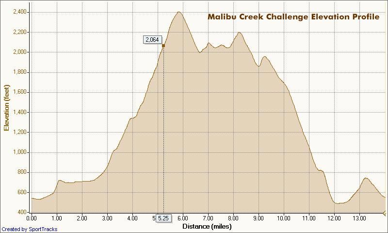
I glanced at my watch — 5.25 miles. Clouds and fog had kept temps on the cool side for more than three-quarters of the Bulldog climb, but the sun was finally breaking through. Even though temps were down a few degrees, the long climb had still been grueling. The runner next to me was breathing heavily, and I mentally repeated my Bulldog mantra — don’t redline, don’t redline.


Malibu Creek Challenge 22K Elevation Profile
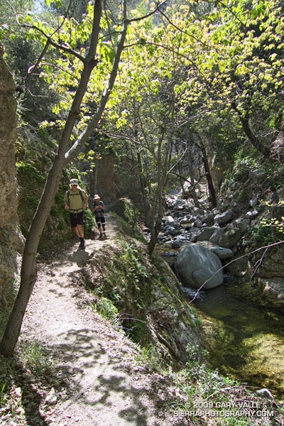
For many of us, that’s the problem with Bulldog — some of it is runnable and some of it isn’t. For the moment I was running, but I knew the grade well, and just ahead the fire road switchbacked right, and steepened.

I’ve been over the “I can run this hill no matter what” thing for a long time. For me, and the majority of trail runners, walking the steeps is a good thing. The little bit of time lost by walking is generally made up — and more — on other sections of the course.

Rounding a corner, the grade did steepen, and I slowed and started to walk. Taking advantage of the slow pace, I ate a Gu, took a Salt Stick cap, and gulped down some Gatorade. Another runner and I had been swapping leads up the hill, and he passed me — again. As he increased his lead, I wondered if I should be pushing a little harder.

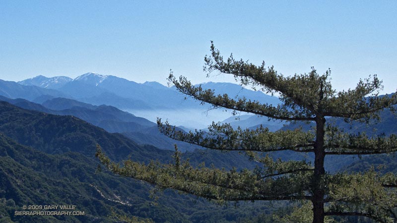
A left turn never felt so good! A few minutes before I had reached the top of Bulldog grade, and the highest point on the course. Now gravity was on my side, and I was enjoying the downhill. There were more challenges ahead, but for now I was lost in the moment — savoring the wind in my face, the far reaching views along the rocky crest, and that wonderful feeling of being a runner.

Here’s a Cesium browser View of a GPS trace of the 22K course with my half-mile splits. (Generated in SportTracks.) See the XTERRA Malibu Creek Trail Run web page for race results and additional info.

Some related posts: Malibu Creek State Park Shadow & Sun, Fog Along Malibu Creek, Bulldog Loop and the Corral Fire, Rock Formations Along the Backbone Trail

Classic Cheeseboro Canyon

Cheeseboro Canyon

The 13 mile keyhole loop through Las Virgenes and Cheeseboro Canyons from the Ahmanson Victory trailhead is a classic Southern California mix of multi-use fire roads and single track trail.

The segment from Shepherd’s Flat down through Cheeseboro Canyon is especially popular, and on the weekend you’ll find an assortment of hikers, runners, mountain bikers, and sometimes an equestrian group or two. Even on a warm day, the oak-shaded sections of the canyon can be surprisingly comfortable.

Here’s a Google Earth image and Cesium browser View of a GPS trace of the loop, and links to trail maps for Upper Las Virgenes Canyon Open Space Preserve (formerly Ahmanson Ranch) and Cheeseboro/Palo Comado Canyons.

Running Cadence, Kayaking and the Forerunner 50

Running cadence

A search on the phrases “stride rate” or “running cadence” will turn up numerous articles extolling the benefits of a running cadence (stride rate) in the neighborhood of 90. An often quoted source of this axiom is Daniels’ Running Formula: Proven Programs: 800 M to the Marathon (Human Kinetics, 2004). The idea is that for a given speed, the faster your stride rate, the less time your body will spend airborne, the less you displace your center of mass, and the softer you hit the ground on landing. Less up and down should translate to more energy efficient running.

It makes sense that there is combination of stride rate, pace, body mechanics and other factors that will be the most efficient for a particular runner. One runner found his optimal stride rates by setting a treadmill to specific speeds, and then finding the stride rate that resulted in the lowest heart rate at a particular speed.

Numerous coaches speak of the benefits of an increased stride rate. Coach Jenny Hadfield in Run Faster, Easier in Runner’s World, wrote that increasing your stride rate is “the single easiest thing to change with your running and it will have a tremendous effect on your speed, effort level and risk for injury.”

That sounded pretty good to me, so a few months ago I started measuring my running cadence by counting foot strikes — left foot, left foot, left foot. Running at a training pace on fire roads and trails, my stride rate averaged about 80 — there was plenty of room for improvement.

From time to time I worked on increasing my stride rate, but seemed to be stuck at a rate of about 83-84. I could artificially increase my cadence above that level, but I was trying to find a way I could maintain a stride rate of over 85 for more than a couple of minutes.

GarminForerunner50 Part of the problem was that counting strides was a pain. That problem was solved by a Garmin Forerunner 50. With a street price as low as $80 with HRM and Footpod (Costco 4/26/09), the device measures distance, speed, heart rate, and running cadence. Using the FR50, I could get immediate feedback on my stride rate, as well as compare how the rate varied on the same course from run to run.


Around New Years, I was out at Ahmanson Ranch, working on my stride rate. It just wasn’t happening. Daydreaming about kayaking, I thought about a kayaking coach’s comments regarding improving my forward stroke. Sit tall. Lean forward a little by rotating the pelvis, and projecting the chest forward. Didn’t I hear something similar to that in Scott Jurek’s video about uphill running technique? I wonder…

Trying these changes in technique, I immediately felt the difference. I glanced at my watch, and my cadence was 88 — and it was staying there!

In the weeks following this breakthrough, I’ve recorded personal bests on all my regular Ahmanson courses. I’ve been trying to apply the changes in technique to more of my running, and make it more second nature. It’s going to take some time, but so far I’m happy with the results.

Red Box – Bear Canyon Loop

Running in Bear Canyon.

Bear Canyon

The creek burbled a gentle song of Spring, and downstream a Canyon Wren replied. Standing near the bottom of the narrow gorge, my eyes followed the soaring trunks of a grove of alders to their canopy of new leaves — backlit and bright green in the sun.

Bright green in the sun… In my run-altered state it was one of those aha! moments. The alders are just tall enough to reach from the shadows of the canyon into the sun – and – without the water in the stream that cut the canyon, the alders could not grow to the necessary height. The pieces fit — or was it the endorphins talking?

We were in Bear Canyon, west of Mt. Wilson, about 10 miles and 15 stream crossings into a 20 mile loop. An  idyllic hike along Arroyo Seco a couple of weeks before had reminded me of this wonderfully wild trail.


Our adventure had started at Red Box, on Angeles Crest Highway. Working east down the Gabrielino Trail to the West Fork San Gabriel River, snow could be seen glistening in the morning sun on Mt. Baldy’s summit slopes. There was no snow on our trail, just warm sun, buzzing bees and blooming manzanita. Continuing down the forested river canyon, we followed the Gabrielino Trail to Valley Forge, and then ascended the winding Valley Forge Trail to Eaton Saddle on the Mt. Wilson Road.

At the Mt. Lowe fire road gate at Eaton Saddle we were greeted by yellow warning tape and an “Unsafe for Travel” sign. What had happened? Did Mueller Tunnel collapse or something? Not inclined to turn back, we continued along the road, promising ourselves that we wouldn’t do anything reckless.


Other than the tracks of heavy equipment, nothing seemed out of the ordinary as we approached the tunnel. I had forgotten that the tunnel is curved, and for a moment was concerned when I couldn’t see the exit. But a couple of strides later the arched exit burst into view. The danger was an old one — an ongoing rock slide just beyond the western exit of the tunnel. There must have been a big slide recently. At the moment it was passable, and we figured as long as we didn’t stop under the slide, we’d probably be OK.

From Markham Saddle we followed the Mt. Lowe fire road out Mt Lowe’s elongated west ridge to a single track trail that leads down to Tom Sloan Saddle. From here, the Bear Canyon Trail descends into Bear Canyon following the route of the old Tom Sloan Trail.

Down in the canyon, I was glad to see that the neo-orange plastic tape that had marked the trail in 2007 was now tattered and faded, and not easily seen. Part of the enjoyment of a remote trail is its wildness. The trail descends the canyon — it has nowhere else to go. When progress is blocked on one side of the stream, it crosses to the other side. Plastic tape isn’t needed to show the way.


After many such stream crossings, we eventually worked our way down to the confluence of Bear Creek and Arroyo Seco. Along this reach there is a fantastic series of falls, pools and cascades. Gary Gunder and I were blown away by these drops when we kayaked Arroyo Seco down to JPL in 1998.

Following the Bear Creek trail upstream, we were careful not to miss the turn where the trail climbs steeply to the Gabrielino Trail and traverses above Switzer Falls. At Switzers Picnic area we parted ways — Miklos and Krisztina headed back to their car at Clear Creek, and I continued up Arroyo Seco to Red Box. It was a incredibly scenic and enjoyable trail run.

Here’s a Google Earth image and live Cesium ion view of a GPS trace of the Red Box – Bear Canyon – Switzers Loop. According to SportTracks the length of the loop was 19.5 miles with an elevation gain/loss of around 4000 ft.

Related posts: Falls Leaves on Bear Creek, Strawberry – Bear Canyon Loop

Overcoming Obstacles on the Trail

Part of the fun of running trails is the challenge of overcoming obstacles that may block your progress. These can range from fallen trees and swollen streams, to rattlesnakes and rockslides — or as was the case yesterday on Lasky Mesa in Upper Las Virgenes Canyon Open Space Preserve, the occasional stray truck.

The truck was part of a assemblage of vehicles associated with a production company. The Ahmanson Ranch area is favored for film production, and classics such as Gone with the Wind, They Died With Their Boots On, The Charge of the Light Brigade, The Thundering Herd, and Duel in the Sun were filmed here. More recently, the bridge scene in Mission Impossible III was shot here.

Spring on the Bent Arrow Trail

Encelia Along the Bent Arrow Trail

I usually do the 21 mile Will Rogers – Temescal loop once or twice a year, and that’s just long enough to forget the difficulty of the strenuous climbs, and remember the outstanding downhill on the Backbone trail, great views of the city, and lush growth in Temescal Canyon.

If the day is warm the return from the coast can be particularly brutal. Today it was cloudy and cool for much of the run, and it wasn’t until the final mile on the Bent Arrow Trail that the sun broke through.