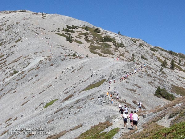
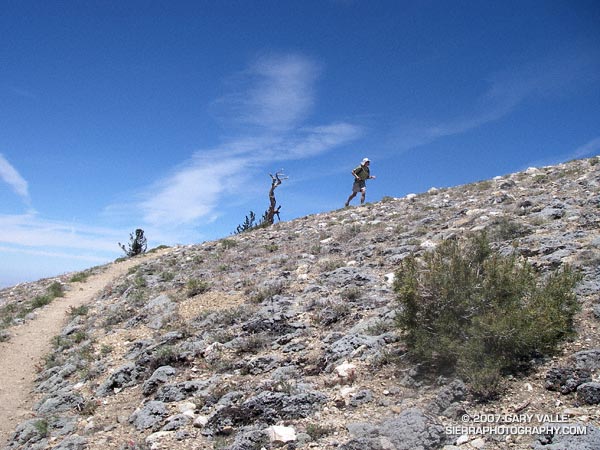
Despite an ongoing heat wave and excessive heat warnings, temps were surprisingly moderate for the 42nd running of the Mt. Baldy Run to the Top race. This year the men’s overall winner was Eric Martin in a time of 1:10:04, and the women’s overall winner was Brigid Freyne in a time of 1:30:41. For all of the results see the Run to the Top web site. Many thanks to the race organizers, volunteers, USFS, Mt Baldy Ski Lifts and the Mt. Baldy Fire Department for a great race!
I hadn’t done this course in midsummer, but a long run close to home, and an early morning ascent of Simi Peak sounded like a nice change of pace. A dawn start from El Scorpion Park put me on the peak and back to the car before temps got out of hand.
On the way out to Simi Peak I usually run up Las Virgenes Canyon and then follow a single track popular with mountain-bikers to Shepherds’ Flat. From here the Sheep Corral Trail leads west to the Palo Comado Canyon fire road, which can be followed up to China Flat. On the way back, from Shepherds’ Flat I run down the Cheeseboro Canyon trail to a connector that can be followed east back to Las Virgenes Canyon. Done this way, and tacking on a short scenic tour of China Flat, the route works out to be about 22.5 miles, with an elevation gain and loss of about 2200 ft. Here’s a Google Earth image and Google Earth KMZ file of a GPS trace of the run.
There is an extensive network of trails in Upper Las Virgenes Canyon Open Space Preserve (trail map) and Cheeseboro/Palo Comado Canyons (trail map) , and many routes to Simi Peak are possible. El Scorpion Park is the most distant trailhead from Simi Peak. Starting at the Victory trailhead will decrease the round-trip mileage by about 2.5 miles, and from the Las Virgenes trailhead by about 6 miles. Simi Peak can also be accessed from the Cheeseboro Canyon, Lindero Canyon, Lang Ranch, and Long Canyon trailheads.
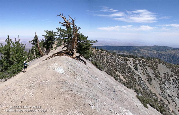
A grizzled guardian of the San Gabriel Mountains, the Wally Waldron Tree stands defiantly astride an airy, rock strewn ridge, just below the summit of 9399 ft. Mt. Baden-Powell.
Perched on the brink of the mountain’s precipitous southeast face, the weather-sculpted Limber Pine is at an elevation and in an environment similar to the 4000+ yr. old White Mountain Bristlecone Pines. Burnished and hardened, the tree’s huge, gnarled roots anchor it firmly to the mountain, helping it to resist the whims of weather and time. The tree is estimated to be 1500 years old.
We had stopped to visit the tree part way through an approximately 23.5 mile loop from Islip Saddle. Our route had descended to South Fork Campground (4560′), before climbing back up to Vincent Gap and Mt. Baden-Powell. In a few minutes we would continue to Baden-Powell’s summit, and from there follow the PCT along the crest back to Islip Saddle. Here’s a Google Earth image and Google Earth KMZ file of a GPS trace of the loop.
Water Notes: The little stream on the Manzanita Trail about 1.5 miles from Vincent Gap was still running. The flow from Little Jimmy Spring was lower than normal, but still very reasonable. We did not detour to Lamil Spring.
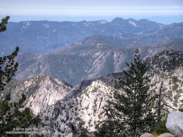
Mt. Wilson, Occidental Peak, Mt. Markham, San Gabriel Peak, Mt. Disappointment, and Mt. Deception from the summit of Twin Peaks, in the San Gabriel Mountains.
Mt. Markham (5742′) is the craggy peak along the skyline, just right of the centerline of the photograph. The bump to the left of Mt. Markham is Occidental Peak (5732′). To the right of Mt. Markham is the highest peak in the group, San Gabriel Peak (6161′). To the right of San Gabriel Peak are Mt. Disappointment (5960′), and Mt. Deception (5796′). The indistinct summit of Mt. Wilson (5710′), and the observatory, are on the left.
Guardian of the rugged San Gabriel Wilderness, Twin Peaks (7761′) has an isolated, high mountain feel. Its flanks drop more than 5000 feet to Devils Canyon on the southwest, and Bear Canyon on the southeast.
We climbed Twin Peaks while doing a point to point run from Buckhorn to Three Points. Including the peak, the run/hike was about 13 miles, with an elevation gain of about 3200′. Here’s a Google Earth image and Google Earth KMZ file of a GPS trace of the route.
This was my first time back to Mt. Pinos since being caught in a fierce thunderstorm last July. No thunderstorms this time — just wonderful running on the air-conditioned ridge between Mt. Pinos and Mt. Abel.
My route was the same as that described in the post Vincent Tumamait Trail. Here’s a Google Earth image and Google Earth KMZ file of a GPS trace of the route.
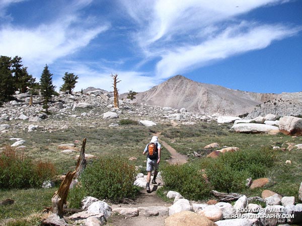
The sky was brightening in the east, and sunrise was approaching when I met Miklos and Krisztina at the Denny’s in Sylmar. We were already wasting light. The plan was to drive from near sea level up to Horseshoe Meadows, at about 10,000′ on the Sierra east side. The hike/run we had in mind was a keyhole loop from the Cottonwood Lakes Trailhead up (old) Army Pass and then down New Army Pass. If we felt OK at the top of Army Pass, we would also do Mt. Langley (14,026′).
The weather forecast looked good. There was a chance of some gusty southwest winds in the afternoon, but temps were warm and there was virtually no chance of T-storms. With a record low Southern Sierra snowpack, there was almost no chance that an ice axe would be required on Army Pass. I was familiar with the route on Langley and down from New Army Pass, and expected to be back to the car well before sunset. But, just in case, the moon was about half full.
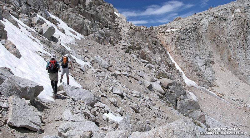
Low snow year on Army Pass. June 23, 2007.
In fact, there had been very little snow on Army Pass, or anywhere else. We reached the pass relatively quickly, and decided to continue to Langley. Now, after another hour of hiking, we were above a prominent rock band that extends across Langley’s south face, and making good progress.
I’ve been convinced for some time that pursed-lip breathing helps me at higher altitudes, particularly when I’m not well acclimated. There’s a skill to it. There seems to me an optimum blend of heart rate, respiratory rate, and the amount of resistance created on exhalation. When all these factors are in balance, the breathing technique is almost automatic and effortless, and it really does seem to help. It certainly seemed to be helping me now.
I topped out a few hundred yards west of the summit, and ambled over to the high point of the peak. On a scale of 1 to 10, I felt pretty good — maybe a 7. Making an effort to stay hydrated, consume plenty of calories, and not push the pace too hard seemed to have worked — at least this time.
The view along the crest to Mt. Whitney and the peaks of the Kings-Kern Divide was telling. It was remarkable just how little snow there was at the highest elevations of the Sierra. A week before I had been paddling the Kern River. Now I could see why the flow on the upper Kern was dropping so fast.
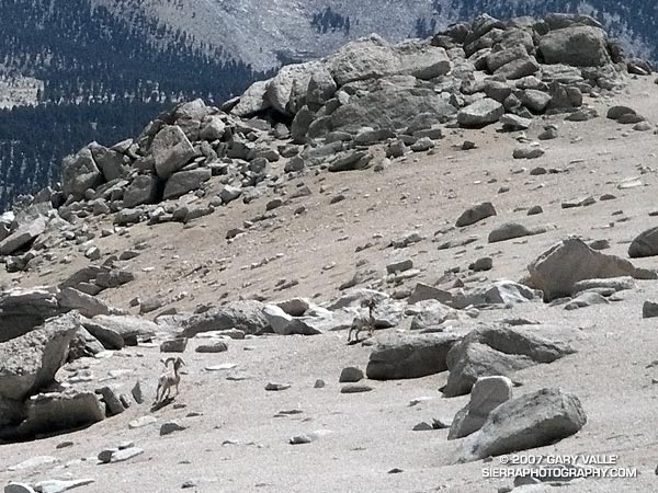
Big horn sheep on the slopes of Mt. Langley. June 23, 2007.
Miklos and Krisztina joined me on the summit, and after taking a few summit photos, we headed down. Screeing down the slopes below the rock band, we were startled when a herd of perhaps 20 big horn sheep rumbled across the slopes below us. They flowed across the rough landscape like quicksilver. Graceful and robust, they moved effortlessly between the rocks and up a small slope. In the moments it took me to react, grab my camera, and turn it on, all but two large rams trailing the group, had disappeared.
Energized by the sight of these fleet-footed animals, we continued down to the saddle at Army Pass, and then up and over New Army Pass. Before sunset we would be back to the car, and before dark, eating dinner at Lone Pine. Before midnight we would be back in L.A. Here’s a Google Earth image and Google Earth KMZ file of a GPS trace of our route.
Note: Going to higher altitudes without properly acclimating can result in very serious, life-threatening illnesses. There is much information available on the Internet regarding altitude sickness and acclimatization. As a starting point see UIAA Medical Commission – Advice and Recommendations and Wikipedia: Altitude sickness.