Category Archives: running|adventures

Trailer Canyon – Santa Ynez Canyon Trail – Trippet Ranch Loop

Santa Ynez Canyon Trail in Topanga State Park.
Santa Ynez Canyon Trail.


The 17.5-mile Trailer Canyon – Santa Ynez Canyon Trail – Trippet Ranch Loop is a longer version of the venerable Trippet Ranch loop from the Top of Reseda. It might also be called the Three Vistas Loop because it visits three high points in Topanga State Park with 360-degree, panoramic views.

Eagle Rock from Temescal Peak in Topanga State Park.
Eagle Rock from Temescal Peak.

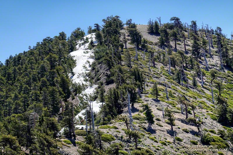
The run starts and ends the same as the Trippet Ranch Loop. After running up to the Hub on Fire Road #30, instead of continuing straight on Eagle Springs Fire Road, this route turns left on Temescal Ridge Fire Road. The fire road is followed up to where the Backbone Trail single-track forks left off the road. The Backbone Trail is followed a tenth of a mile east, where a path leads up and left to the top of Temescal Peak.

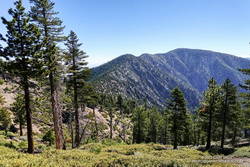
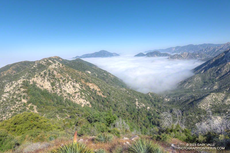
The view from this little peak is superb. On a day with good visibility, the view can extend beyond Mt. Baldy to San Gorgonio Mountain and San Jacinto Peak. The next overlook on this route, Temescal Lookout, is about a half-mile (as the crow flies) to the south. The third overlook, Eagle Rock, is about a mile to the west.

Scarlet larkspur along the Santa Ynez Canyon Trail.
Scarlet larkspur.

From Temescal Peak, the route returns to Temescal Ridge Fire Road. I usually follow the use-trail back down and across the Backbone Trail and then continue on the use-trail to the fire road.

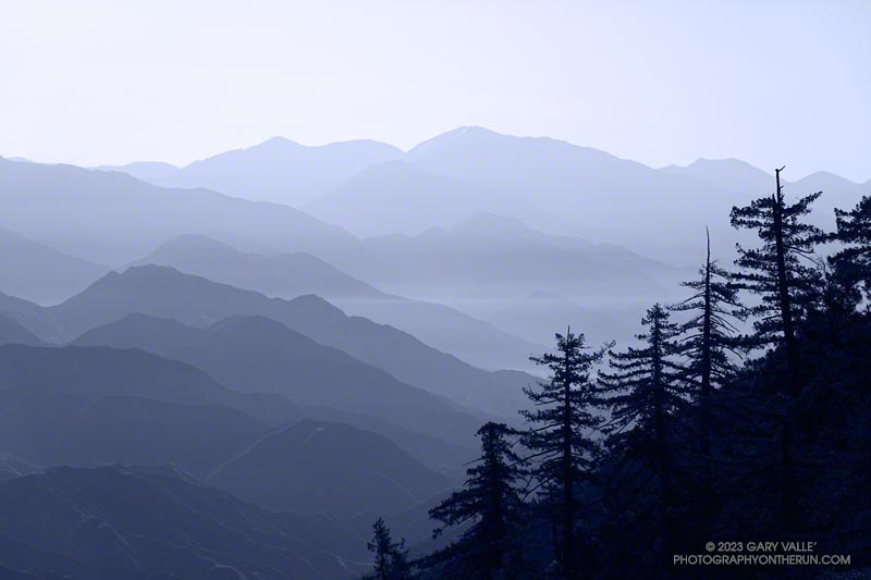
The next stop, Temescal Lookout, is about a mile from the top of Temescal Peak and just off Temescal Ridge Fire Road. When doing this loop, I run up a dirt access road on the north side of the lookout and then descend a use trail on the south side. Once the site of a fire lookout, it also has an excellent view. This photo of Downtown and San Jacinto Peak was taken from the viewpoint.

A pool on Santa Ynez Creek. July 2023.
Pool on Santa Ynez Creek.

Once back on Temescal Ridge Fire Road and headed south, it’s less than a half-mile to the turn-off down Trailer Canyon Fire Road and then another 2.3 miles down to Michael Lane in Pacific Palisades. On the way down, there are good views of where the loop is headed next — Santa Ynez Canyon. A large part of Santa Ynez Canyon was burned in the May 2021 Palisades Fire.

After turning right (west) on Michael Lane, the street is followed around and down to Vereda de la Montura. A right turn here leads to the Santa Ynez Canyon Trailhead in about a quarter-mile. This is where some route-finding fun begins.

Scarlet monkeyflower on a tributary of Garapito Creek.
Scarlet monkeyflower.

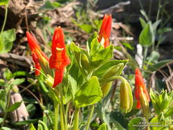
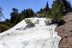
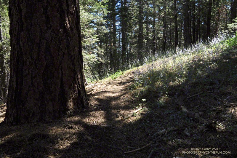
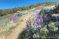
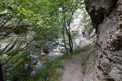
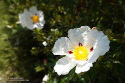
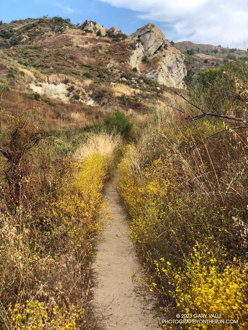
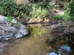
Heavy rains in December 2021 washed out sections of the Santa Ynez Canyon Trail. During the 2022-2023 rain season, the trail took it on the chin again. The good news is the trail sees a lot of use and the washed-out sections are becoming reestablished. There was still a little running water in the creek. Part way up the canyon, I was surprised to find pennyroyal blooming along the trail.

A bit more than a mile from the trailhead, the Santa Ynez Canyon Trail climbs out of the bottom of the canyon and up onto a broad ridge. Another mile of uphill, and it tops out at Eagle Springs Fire Road. After turning left, it’s less than a half-mile down to the Trippet Ranch parking lot.

Humboldt lily along the Garapito Trail.
Humboldt lily.

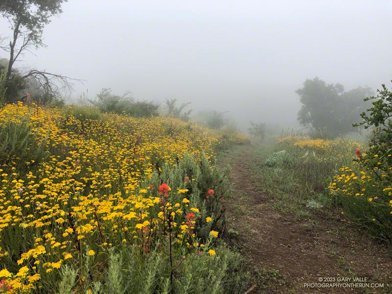
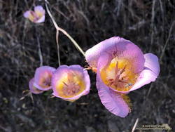
The previous weekend I’d done the Trippet Ranch Loop, so knew what the expect on the remainder of the run. Other than being a little overgrown, the Musch Trail was in reasonable shape. There were still some late-season blooms of showy penstemon, yellow monkeyflower, and white snapdragon along the trail. This time of year, the round pincushions of buckwheat are common. Water was available at the start of the Musch Trail and at Musch Camp.

Reaching the top of the Musch Trail, high clouds kept the temperature comfortable as I worked up Eagle Rock Fire Road. At the turn-off to climb Eagle Rock, digger bees had established a temporary colony on the fire road. In my experience, these bees are not aggressive, BUT many sources — such as this news item from ISU Extension and Outreach — say the female bees can sting.

Hiker ascending Eagle Rock in Topanga State Park.
Hiker ascending Eagle Rock.

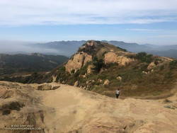
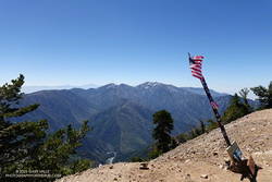
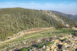
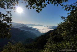
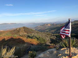
Eagle Rock is the third viewpoint on the loop, and the most popular. The massive rock formation overlooks Santa Ynez Canyon and has an airy, 360-degree view. On a clear day, Santa Monica Bay, Palos Verdes Peninsula, and Catalina can be seen to the south. On weekends, it’s rare to find the top empty. The summit had just been vacated as I climbed up and was reoccupied by another hiker as I walked down.

Returning to Eagle Rock Fire Road, I turned right and continued northeast a tenth of a mile to the top of the Garapito Trail.

Plummer's mariposa lily along the Garapito Trail.
Plummer’s mariposa lily.

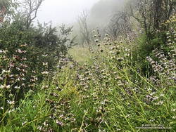
A little more than three miles long, the Garapito Trail is one of my favorite trails in the Santa Monica Mountains. Several sections of the trail are overgrown at the moment. At one point, not too far from Fire Road #30, it was necessary to bushwhack through a dense patch of six-foot-tall giant rye grass.

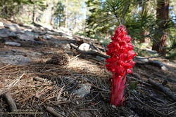
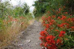
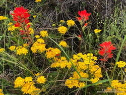
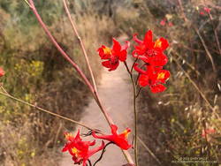
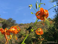
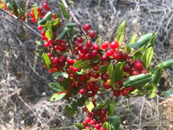
Two lilies listed on the CNPS Inventory of Rare and Endangered Plants of California were blooming along the Garapito Trail — Plummer’s mariposa lily and Humboldt lily. Both plants have a Rare Plant Rank of 4.2, which indicates they are of limited distribution and moderately threatened in California. Thanks to our very wet rain season, the eye-catching red of scarlet larkspur was unusually prevalent along the trail.

Redberry along the Garapito Trail.
Redberry.

The Garapito Trail ends at Fire Road #30. Normally the route would cross the fire road and follow the Bent Arrow Trail to dirt Mulholland, but the trail was damaged by rainy season storms and is still closed.

Turning left onto Fire Road #30, I retraced my steps from earlier in the morning and in a few minutes was back to the trailhead at the Top of Reseda (Marvin Braude Mulholland Gateway Park).

Explore the scenery and terrain of the Trailer Canyon – Santa Ynez Canyon Trail – Trippet Ranch Loop using our high resolution,  interactive, 3D viewer. The imagery is so detailed, it’s almost like being there! To change the view, use the control on the upper right side of the screen, the CTRL key and your mouse, or touch gestures. Track and placename locations are approximate and subject to errors. Poor weather, and other conditions may make this route unsuitable for this activity.

Some related posts: Trippet Ranch Loop Plus the Santa Ynez Trail, Garapito Trail Runs, Go Figure, Trippet Ranch Wildflower Run, Eagle Rock – Topanga State Park

It’s Mid-July And There Is Still Snow in Los Angeles County!

Snow in the lee of the West Ridge of Mt. Baden-Powell.

You might not see it from the Los Angeles side of the mountains, but there is still some snow on the higher, north-facing slopes of the San Gabriel Mountains.

During and after storms, snow-laden southerly winds dump their load on the backside of the crest, creating deep drifts, cornices, and compacted slabs of snow. This snow is often the last to melt, not only because it doesn’t face the sun, but because there is more of it.

Mt. Burnham, Peak 9086, and Mt. Baden-Powell from near Throop Peak.

This morning, I was doing an out-and-back from the Windy Gap Trailhead in the Crystal Lake Recreation Area to Mt. Baden-Powell. The Windy Gap Trail climbs 1730′ in 2.6 miles, joining the PCT at Windy Gap. From there the trail follows the spine of the San Gabriels past Mt. Hawkins, Throop Peak, and Mt. Burnham to Mt. Baden-Powell.

I usually do this run from Islip Saddle, but with Angeles Crest Highway (Highway 2) closed between Red Box and Vincent Gap, the Islip Saddle trailhead isn’t accessible.

Snow on the west ridge of Mt. Baden-Powell. July 9, 2023.
Snow at about 9100′ on the west side of Mt. Baden-Powell.

Whether you start at Crystal Lake or Islip Saddle, the length of the run is about the same — a bit over 16 miles. The main difference is that the Windy Gap Trailhead is about 800′ lower in elevation. On the plus side, the Windy Gap Trail is very scenic; on the minus side, it faces south and can bake in the midday sun.

On today’s run, I encountered the first snowbanks at an elevation of 8870′, near the Dawson Saddle Trail junction. Out of curiosity, I tried to follow the trail and soon realized that was a mistake. I was more or less forced to skirt the downhill side of a lengthy and deep drift — it being too steep and icy to cross directly.

Mt. Baldy from the summit of Mt. Baden-Powell. July 9, 2023.

For the remainder of the run, I switched to the early season tactic of staying on the crest when the trail deviated onto shaded, north-facing slopes. These areas might have significant snow on the trail. This only happens in a few places, such as when the PCT works around Mt. Burnham. There is a use trail that ascends the west ridge of Mt. Burnham, and then returns to the PCT.

The conditions today are reminiscent of those found here in early July 2005. July 3rd of that year there was still snow on the summit of Baden-Powell, and there was deeper snow in the areas where there was snow today. We had a lot of storms this rain season, but in Rain Year 2004-2005 Downtown Los Angeles (USC) recorded about 9 inches more rain than during the 2022-2023 rain year!

Here is a short slideshow of some photos taken on the run. I’ve also included a few photos from the run to Baden-Powell in 2005 for comparison.

Escape to Mt. Pinos – An Alternative to Closed Angeles Crest Highway Trailheads

Large Jeffrey pine and larkspur along the Vincent Tumamait Trail in the Chumash Wilderness.
Jeffrey pine and larkspur along the Vincent Tumamait Trail

A long stretch of Angeles Crest Highway (Highway 2) between Red Box and Vincent Gap remains closed because of storm damage. According to a tweet from Caltrans District 7, it sounds like it may be closed through Summer. Some affected trailheads include Shortcut Saddle, Three Points, Mt. Waterman, Buckhorn, Mt. Williamson, and Islip Saddle.

Starting down the Vincent Tumamait Trail, near the Condor Observation Site on Mt. Pinos.
Starting down the Vincent Tumamait Trail

Mt. Pinos is often overlooked as a trail running destination but offers several options for those that enjoy running or hiking in hilly terrain at higher altitude. Most of the runs at Mt. Pinos start at the Chula Vista Trailhead (8350′) at the end of Mt. Pinos Road.

Today, I was doing an out-and-back from the Chula Vista Trailhead to Mt. Abel/Cerro Noroeste (8280+’). The route includes short side trips to Mt. Pinos (8831′), Sawmill Mountain (8818′), Grouse Mountain (8582′), and Sheep Camp (8300′).

Snow plant along the Vincent Tumamait Trail

Including the side trips, the run/hike is about 15.5 miles long, with about 3700′ of gain/loss. Google Earth calculates the average elevation of the route to be 8434′. In comparison, the average elevation of the out and back from Islip Saddle to Mt. Baden-Powell is 8201′.

With triple-digit highs expected in some low-elevation areas, the temps on Mt. Pinos today were ever so pleasant — short-sleeves from the start and only a little toasty in a few exposed areas.

Chumash spirit tower on Sawmill Mountain., west of Mt. Pinos.
Chumash spirit tower on Sawmill Mountain.

Despite the harsh Winter, there were only one or two small trees down on the Vincent Tumamait Trail, and those were inconsequential. As elsewhere in Southern California, the wildflowers along the trail were sensational. After nearly drying up last year, the spring at Sheep Camp was running at full flow.

Explore the scenery and terrain of this out and back run from Mt. Pinos to Mt. Abel using our high resolution,  interactive, 3D viewer. The imagery is so detailed, it’s almost like being there! To change the view, use the control on the upper right side of the screen, the CTRL key and your mouse, or touch gestures. Track and placename locations are approximate and subject to errors. Snow, ice, poor weather, and other conditions may make this route unsuitable for this activity.

Lupine and other wildflowers along the Vincent Tumamait Trail, near Mt. Abel Road.
Lupine and other wildflowers along the trail, near Mt. Abel Road.

If you are looking to run longer, add additional elevation gain, or explore the area, running to Lily Meadows and back from Sheep Camp extends the run to about 21 miles, with around 5400′ of elevation gain/loss.

Another option for a longer run is doing an out-and-back to Mesa Spring Camp, instead of Mt. Abel. Including a stop at Sheep Camp on the way back, this run is about 20.5 miles, with about 4800′ of gain/loss.

Lily Meadows and Mesa Springs see far less traffic than the Vincent Tumamait Trail. The trade-off is that both places are at lower elevation and can be 15-20 degrees warmer than Mt. Pinos.

Some related posts:
Thirsty Mt. Pinos
Mt. Pinos to Mt. Abel Out & Back – Plus Sawmill Mountain, Grouse Mountain and Sheep Camp
Up, Down and Around on Mt. Pinos’ Tumamait and North Fork Trails
Mt. Pinos Adventure Run to Mesa Spring

After the Bobcat Fire: Running the ANFTR 25K Course

San Gabriel Mountains. Photography by Gary Valle'.

On June 1, Angeles National Forest reduced the size of the Bobcat Fire Closure, opening up most of the upper West Fork San Gabriel River area. Curious to see how the West Fork area is recovering from the Bobcat Fire, today I ran a slightly shortened version of the ANFTR/Mt. Disappointment 25K course.

Since the Mt. Wilson parking lot is usually closed until mid-morning, this morning’s run started and ended at a small turnout near the top of the Kenyon Devore Trail on the loop road on Mt. Wilson. The ANFTR Trail Races start at the main Mt. Wilson parking lot.

I’d recently done the San Gabriel Peak and Bill Riley Trails and knew they were in reasonable condition. And I’d read that AC100 Trail Work Teams led by Gary Hilliard and Ken Hamada had cleared the Gabrielino and Kenyon Devore Trails earlier this year. So, I didn’t expect to have a repeat of the epic fallen-tree obstacle course that I experienced doing this course in 2020.

Here’s a slideshow of what I found.

Explore the scenery and terrain of the Mt. Wilson – Red Box – West Fork – Kenyon Devore Loop using our high resolution,  interactive, 3D viewer. The imagery is so detailed, it’s almost like being there! The loop is a slightly shorter version of the ANFTR 25K. To change the view, use the control on the upper right side of the screen, the CTRL key and your mouse, or touch gestures. Track and placename locations are approximate and subject to errors. Snow, ice, poor weather, and other conditions may make this route unsuitable for this activity.

Related post: An ANFTR/Mt. Disappointment 2020 Adventure

Red Box – Bear Canyon – Switzer’s Loop – Memorial Day Weekend 2023

Marine layer pushing into Bear Canyon in the San Gabriel Mountains, near Los Angeles.
Marine layer pushing into Bear Canyon

The Red Box – Bear Canyon – Switzer’s Loop trail run is a favorite I’ve enjoyed doing for many years. Part of its attraction is the isolated, backcountry feel of Bear Canyon, particularly between Tom Sloane Saddle and Bear Canyon Trail Camp. It’s worth spending a few minutes at the old cabin site in the upper canyon to contemplate a lifestyle from an earlier century.

Early morning view from the Bill Reily Trail (aka Mt. Disappointment Trail).
Early morning view from the Bill Riley Trail (aka Mt. Disappointment Trail).

The descent of Bear Canyon is always adventurous in some way. Based on what I’d been seeing on other trails this year, I’d expected upper Bear Canyon to be a mess. I had braced myself for downed trees, washouts, and overgrown, hard-to-follow sections of trail.

But just a few minutes below Tom Sloane Saddle, a tree blocking the trail had been cleared, and the saw cuts were fresh! As I worked down the trail, I was excited to find more trailwork had been done. Branches or trees that had fallen across the trail had been cut. Some overgrown sections of trail had been trimmed. One washed-out section of trail looked like it had just been repaired. Someone had even trimmed a little of the poison oak that is so common along the trail.

Bear Canyon Trail near Arroyo Seco

As I discovered when I encountered them lower in the canyon, the Bear Canyon Trail Crew had been hard at work, and they were working in the canyon again today!

The last time I was in Bear Canyon (April 2021), the creek had been nearly dry. This year there was plenty of water and plenty of stream crossings. Unlike several recent runs, I had my poles and was able to keep my shoes and socks mostly dry.

Trailside wildflower garden on the Bear Canyon Trail.
Trailside wildflower garden

I had debated whether to do this loop on Memorial Day Weekend. It passes through Switzer’s Picnic Area, one of the most popular day-use areas in Angeles National Forest. Many visiting Switzer’s do the hike down the Gabrielino Trail to see Switzer Falls, and many of those continue down the Bear Canyon Trail to the area below the falls.

Today, the two-mile stretch from below the falls to Switzer’s was as busy as expected. One issue I hadn’t anticipated was that some stream crossings were backed up like the Hillary Step on Everest. Other than wading, there was usually only one “dry” route across the stream. At one busy crossing, a hiker — clutching a dog under each arm — deftly balanced across a sequence of slippery rocks and branches, keeping his and his charge’s feet dry.

Crimson-spotted rock rose along the Gabrielino Trail between Switzer's and Red Box
Crimson-spotted rock rose along the Gabrielino Trail

Once past Switzer’s, things returned to normal. From Switzer’s, it’s about 4.5 miles up to Red Box, with an elevation gain of about 1350′. I had been on this section of the Gabrielino Trail about a month before and was curious to see if a mass of fallen trees blocking the trail had been removed.

The trees still needed to be cleared — Forest Service rules require a qualified sawyer to do that kind of work — BUT the remaining 2.5 miles of trail to Red Box were being trimmed and cleared by several dozen members of the Mt. Wilson Bicycling Association. I wondered why I wasn’t seeing any mountain bikers on the trail — they were all working on it!

Here’s an interactive, 3D terrain view of the Red Box – Bear Canyon – Switzer’s Loop. The map can be zoomed, tilted, rotated, and panned. To change the view, use the control on the upper right side of the screen. Track and placename locations are approximate and subject to errors.

Some related posts: Bear Canyon Loop – 2021, Red Box – Bear Canyon Loop Plus Brown Mountain, Bear Canyon Loop Plus Strawberry Peak

Canyon liveforever (Dudleya cymosa) in Bear Canyon.
Canyon liveforever.
Paintbrush along the Gabrielino Trail between Switzer's and Red Box.
Paintbrush along the Gabrielino Trail.

A Really Overgrown Trail, Thirty Creek Crossings, and Thousands of Wildflowers

Yarrow and paintbrush along the Old Boney Trail in Pt. Mugu State Park.
Old Boney Trail in Pt. Mugu State Park.

Starting at the Wendy Drive Trailhead, I’d crossed Satwiwa, run down Danielson Road, rock-hopped across Upper Sycamore Creek, and picked up the Old Boney Trail. The condition of the Old Boney Trail between Danielson Road and the Fossil Trail junction was better than expected. Maybe the trail was going to be in good shape after all.

A section of the Old Boney Trail overgrown with black sage following the wet rain season of 2022-2023.
A section of the Old Boney Trail overgrown with black sage.

Wrong! Once I passed the turnoff to the Fossil Trail, the vegetation closed in. In places it was so thick I couldn’t see the trail at my feet, much less a few yards ahead. All I could do is smile and work my way through it. Everything was overgrown — bushes, grasses, wildflowers. And everything was wet with dew. A hundred yards past the Fossil Trail, I was soaked from head to toe.

I tried to see the positive. It was an amazing display of the effect of a wet rainy season. Without trail work and use, it wouldn’t take long for the trail to be completely consumed.

The Old Boney Trail continued to be a tangle of chaparral for about two miles — until I reached the Backbone Trail at Blue Canyon. At that point, it becomes part of the Backbone Trail system, and I was relieved to see that some work had recently been done on the trail.

Coast live oak and fog along the Old Boney Trail in Pt. Mugu State Park.
Coast live oak along the Old Boney Trail.

As I worked up the Backbone Trail toward the Chamberlain Trail junction, I recalled other times I’d run to Serrano Valley using Old Boney. What would the condition of the trail be beyond this point? I’d been on that part of the Old Boney Trail following a wet rain season and knew how overgrown it could be. Some refer to that section of trail as “tick alley.”

But when I got to the junction, surprise, surprise, the Old Boney Trail had been trimmed. More than two miles of trail were groomed. It was good all the way to the Serrano Valley Trail and partway into Serrano Valley. The trail in Serrano Valley was a little overgrown, but NOTHING like the Old Boney Trail between the Fossil and Backbone Trails.

Part of the fun of doing this route is all the stream crossings in Serrano Canyon — what is it 13 or 14? Today, most of these could be done without getting your shoes wet — especially if you have poles. I didn’t have poles, and my shoes and socks were already wet, so I didn’t worry about keeping them dry. Some sections of the Serrano Canyon Trail were also overgrown, but not bad. However, there was a lot of poison oak, some of which wasn’t avoidable.

Paintbrush and golden yarrow along Sycamore Canyon Fire Road in Pt. Mugu State Park.
Paintbrush and golden yarrow

After getting a drink of water at the faucet at the junction of the Serrano Canyon Trail and Sycamore Canyon Fire Road, I headed up-canyon. Almost immediately, the fire road crossed Big Sycamore Canyon Creek. I did this first crossing without getting my shoes wet, but nine more crossings followed, and most resulted in soaked shoes. The water crossings and wildflowers helped distract me from the five mile run up Sycamore Canyon to the Upper Sycamore Trail.

Getting off Sycamore Canyon Road and onto the Upper Sycamore Trail was a relief. Whatever run I do from Wendy Drive, I always finish it via this trail. The trail gets enough use that it was in good shape. This time all the creek crossings could easily be rock-hopped.

Even with a few tedious sections, it was an adventurous and mostly enjoyable 20 miles. Here are some photos taken along the way.

Some related posts: Old Boney to Serrano Valley, Plus Fireline and Overlook; Looking for Ogres in Serrano Canyon; Running to Serrano and La Jolla Valleys from Wendy Drive; You Can’t Run Just Part Way Up Serrano Canyon