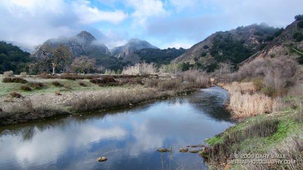
Category Archives: running|adventures

Marin Headlands: Bobcat – Miwok Loop

View toward San Francisco from the Miwok Trail in the Marin Headlands.

Drove up to San Francisco to visit Brett & Amanda and sample a few of the Bay Area’s excellent trails.

Within an hour of arriving in the city we were across the Golden Gate, and running up the Bobcat Trail in the Marin Headlands. The Bobcat – Miwok loop was the first of three courses we were planning to do over the weekend.


Blue-eyed grass along the Bobcat Trail in the Marin Headlands.
This course was an approximately six mile “after work” loop around the Gerbode Valley, with an elevation gain/loss of a little over 1000 ft. My legs were still a little tired from recent runs and I was happy to be doing the loop in the easier counterclockwise direction — up Bobcat and down Miwok. Except for a short segment of single track around the east side of an FAA beacon, the course is entirely on dirt roads. Bobcat sightings are relatively common on this circuit, and we hoped we might spot one.

In the city it was windy and cool, and I had grabbed a long-sleeve shirt for the run. But short sleeves would have been the better call. Here there was almost no wind, and the south facing valley was surprisingly warm — a hint of the record-breaking weather to come. Skies were mostly clear, and views extended south to the city, east across the Bay to Mt. Diablo, and north to Mt. Tamalpais.

Here’s a NPS Marin Headlands Trail Map (PDF) and a Cesium browser View of a GPS trace of our route.

Looking to do a longer run? Numerous variations and trail link-ups are possible. The course of the Miwok 100K winds through here and continues north past Mt. Tam to Bolinas Ridge, descending to a turnaround point at Hwy 1 about 5 miles south of Olema. Cross the Shoreline Highway, and you’re in Pt. Reyes National Seashore. (Bolinas Ridge fire road continues north to Sir Francis Drake Blvd. about a mile east of Olema.)

Tomorrow the Sky Trail at Pt. Reyes… but we are going to drive there.

Malibu Creek Challenge 2009

I glanced at my watch — 5.25 miles. Clouds and fog had kept temps on the cool side for more than three-quarters of the Bulldog climb, but the sun was finally breaking through. Even though temps were down a few degrees, the long climb had still been grueling. The runner next to me was breathing heavily, and I mentally repeated my Bulldog mantra — don’t redline, don’t redline.


Malibu Creek Challenge 22K Elevation Profile
For many of us, that’s the problem with Bulldog — some of it is runnable and some of it isn’t. For the moment I was running, but I knew the grade well, and just ahead the fire road switchbacked right, and steepened.

I’ve been over the “I can run this hill no matter what” thing for a long time. For me, and the majority of trail runners, walking the steeps is a good thing. The little bit of time lost by walking is generally made up — and more — on other sections of the course.

Rounding a corner, the grade did steepen, and I slowed and started to walk. Taking advantage of the slow pace, I ate a Gu, took a Salt Stick cap, and gulped down some Gatorade. Another runner and I had been swapping leads up the hill, and he passed me — again. As he increased his lead, I wondered if I should be pushing a little harder.

A left turn never felt so good! A few minutes before I had reached the top of Bulldog grade, and the highest point on the course. Now gravity was on my side, and I was enjoying the downhill. There were more challenges ahead, but for now I was lost in the moment — savoring the wind in my face, the far reaching views along the rocky crest, and that wonderful feeling of being a runner.

Here’s a Cesium browser View of a GPS trace of the 22K course with my half-mile splits. (Generated in SportTracks.) See the XTERRA Malibu Creek Trail Run web page for race results and additional info.

Some related posts: Malibu Creek State Park Shadow & Sun, Fog Along Malibu Creek, Bulldog Loop and the Corral Fire, Rock Formations Along the Backbone Trail

Red Box – Bear Canyon Loop

Running in Bear Canyon.

Bear Canyon

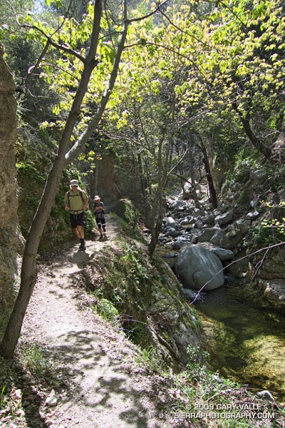
The creek burbled a gentle song of Spring, and downstream a Canyon Wren replied. Standing near the bottom of the narrow gorge, my eyes followed the soaring trunks of a grove of alders to their canopy of new leaves — backlit and bright green in the sun.

Bright green in the sun… In my run-altered state it was one of those aha! moments. The alders are just tall enough to reach from the shadows of the canyon into the sun – and – without the water in the stream that cut the canyon, the alders could not grow to the necessary height. The pieces fit — or was it the endorphins talking?

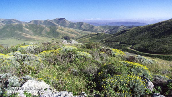
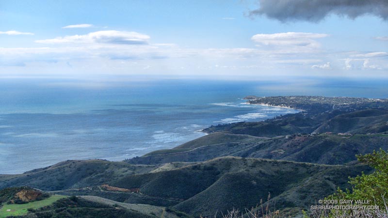
We were in Bear Canyon, west of Mt. Wilson, about 10 miles and 15 stream crossings into a 20 mile loop. An  idyllic hike along Arroyo Seco a couple of weeks before had reminded me of this wonderfully wild trail.


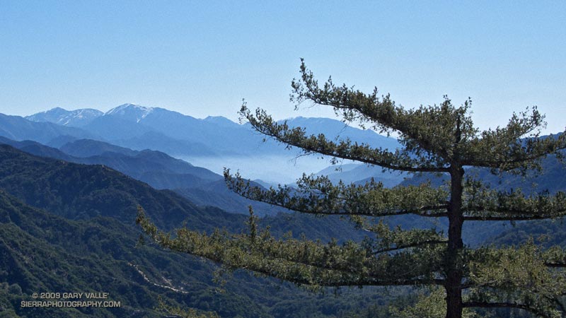
Our adventure had started at Red Box, on Angeles Crest Highway. Working east down the Gabrielino Trail to the West Fork San Gabriel River, snow could be seen glistening in the morning sun on Mt. Baldy’s summit slopes. There was no snow on our trail, just warm sun, buzzing bees and blooming manzanita. Continuing down the forested river canyon, we followed the Gabrielino Trail to Valley Forge, and then ascended the winding Valley Forge Trail to Eaton Saddle on the Mt. Wilson Road.

At the Mt. Lowe fire road gate at Eaton Saddle we were greeted by yellow warning tape and an “Unsafe for Travel” sign. What had happened? Did Mueller Tunnel collapse or something? Not inclined to turn back, we continued along the road, promising ourselves that we wouldn’t do anything reckless.


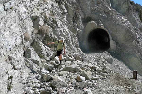
Other than the tracks of heavy equipment, nothing seemed out of the ordinary as we approached the tunnel. I had forgotten that the tunnel is curved, and for a moment was concerned when I couldn’t see the exit. But a couple of strides later the arched exit burst into view. The danger was an old one — an ongoing rock slide just beyond the western exit of the tunnel. There must have been a big slide recently. At the moment it was passable, and we figured as long as we didn’t stop under the slide, we’d probably be OK.

From Markham Saddle we followed the Mt. Lowe fire road out Mt Lowe’s elongated west ridge to a single track trail that leads down to Tom Sloan Saddle. From here, the Bear Canyon Trail descends into Bear Canyon following the route of the old Tom Sloan Trail.

Down in the canyon, I was glad to see that the neo-orange plastic tape that had marked the trail in 2007 was now tattered and faded, and not easily seen. Part of the enjoyment of a remote trail is its wildness. The trail descends the canyon — it has nowhere else to go. When progress is blocked on one side of the stream, it crosses to the other side. Plastic tape isn’t needed to show the way.


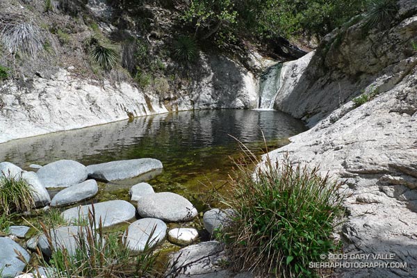
After many such stream crossings, we eventually worked our way down to the confluence of Bear Creek and Arroyo Seco. Along this reach there is a fantastic series of falls, pools and cascades. Gary Gunder and I were blown away by these drops when we kayaked Arroyo Seco down to JPL in 1998.

Following the Bear Creek trail upstream, we were careful not to miss the turn where the trail climbs steeply to the Gabrielino Trail and traverses above Switzer Falls. At Switzers Picnic area we parted ways — Miklos and Krisztina headed back to their car at Clear Creek, and I continued up Arroyo Seco to Red Box. It was a incredibly scenic and enjoyable trail run.

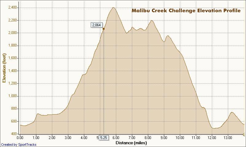
Here’s a Google Earth image and live Cesium ion view of a GPS trace of the Red Box – Bear Canyon – Switzers Loop. According to SportTracks the length of the loop was 19.5 miles with an elevation gain/loss of around 4000 ft.

Related posts: Falls Leaves on Bear Creek, Strawberry – Bear Canyon Loop

Above Satwiwa

A view of the Conejo Valley from the crags west of the Danielson cabin site.

A view of the Conejo Valley from the crags west of the Danielson cabin site. The grassland area in the valley is Rancho Sierra Vista/Satwiwa in Newbury Park, California.

From Sunday’s adventure hike and run to Sandstone Peak in the Santa Monica Mountains.

Related post: Satwiwa Loop Trail

Sandstone Peak from Wendy Drive

Big Dome and Sandstone Peak from Tri-Peaks

Whatever route you use to get there, Sandstone Peak (3111 ft.) is a rewarding summit with sweeping views that range from the Channel Islands to Mt. Baldy and beyond. It is the highest peak in the Santa Monica Mountains, and a popular destination.

The peak is usually done as a steep 3-mile hike (round trip) from the Sandstone Peak Trailhead, or as part of a scenic 6-mile loop from the Mishe Mokwa trailhead. This National Park Service PDF provides additional information and a map of these trails.

A third option is to skip the drive to Yerba Buena Rd., and do the peak as an adventure hike/run from Wendy Drive trailhead in the Conejo Valley. This can be done by ascending one of the routes on the north side of Boney Mountain, then continuing up and over Tri-Peaks to the Mishe Mokwa/Backbone trail junction. From here the Backbone Trail leads to a spur trail that climbs the peak.

View west from Sandstone Peak of the Boney Mountain massif.

We took this last option and climbed Boney Mountain’s more technical western ridge. Done this way, it was about 6.8 miles to Sandstone Peak’s summit, with an elevation gain of about 3100 ft. This includes the short side trip to the high point near the top of the western ridge generally referred to as “Boney Mountain.”

Here’s a view west from Sandstone Peak of the Boney Mountain summit area. Tri-Peaks is the rocky peak on the skyline, right of center, and Big Dome is to the right of Tri-Peaks. The route up the western ridge tops out on the crest between these two peaks. (As seen from Sandstone Peak.)

The basic choices for getting back to the Wendy Drive trailhead are to go back down one of the trails on Boney Mountain’s north side; descend the Chamberlain Trail to the Old Boney Trail, and then loop back over the shoulder of Boney, or descend to Big Sycamore Canyon and then return from there.

Miklos and Krisztina had not run down Boney’s eastern ridge, so they backtracked over Tri-Peaks, and descended the use trail to the Danielson cabin site. I was looking to do some additional mileage, so ran down the Chamberlain, Old Boney, and Blue Canyon trails to the Danielson multi-use area in Big Sycamore Canyon, and then up Sycamore Canyon to the Upper Sycamore Trail, and back to Satwiwa.

Here’s a  Cesium ion view of a GPS trace of my route. The eastern ridge route is also shown.

Related posts: Balance Rock, Boney Mountain Western Ridge & Loop

Malibu Creek State Park Shadow & Sun

Malibu Creek State Park

My trail running shoes had not been wet or muddy since sometime in December. During the entire month of January, Downtown Los Angeles (USC) recorded about one-third of an inch of rain. Not only had it been dry, it had been warm. On a dozen of those January days, the high temperature topped eighty degrees, setting a new record!

But Winter had returned. The past three days, Los Angeles had received about 1.5 inches of rain, valley and foothill locations 2-4 inches, and some mountain stations as much as 5-7 inches. And more Winter weather was on the way. Excited about the change in the weather, today’s run was one with good muck and mire potential — the Bulldog Loop in Malibu Creek State Park.

We were not disappointed. Near Century Lake, mud the consistency of peanut butter pulled at our shoes and slowed the climb up Crags Rd, Further west, near the M*A*S*H site, calf-deep water on the trail washed the gunk off.


Pt. Dume from the Mesa Peak ridgeline.
The trail conditions on the remainder of the loop were more straightforward. From time to time, shafts of sun would pierce the clouds, resulting in a patchwork of shadow and sun that emphasized the rugged terrain. Along the crest, the ocean views were superb! Before descending to Tapia Park we ran out to Mesa Peak, and then followed the ridgeline to an overlook of the coast. (Marked peak 1800 on the topo.)

Including the side trip to the overlook, this variation of the Bulldog loop worked out to an exhilarating 16.5 miles, with an elevation gain/loss of about 2700 ft.

If current forecasts and outlooks for this month hold true, this won’t be our last wet and muddy trail run this February. In a couple of weeks, Los Angeles rainfall totals may climb above normal for the first time this rain season. We’ll see!

Some related posts: Fog Along Malibu Creek, Bulldog Loop and the Corral Fire