Category Archives: malibu creek state park

Exploring the Lake Vista Trail and Ridge

Malibu Creek, Goat Buttes and Century Lake from Lake Vista Butte

This morning’s running plan morphed from doing a loop I’ve done many times, to exploring a trail I hadn’t done, and hiking along a ridge to the top of a butte with a sweeping view of Malibu Creek State Park.

Lake Vista Ridge and Butte in Malibu Creek State Park

My run started at the Cistern Trailhead on Mulholland Highway. After descending the Cistern Trail, I picked up the Lookout Trail and headed west to the top of the Cage Creek Trail and the start of the Yearling Trail. Continuing on the Yearling Trail, I turned left (south) up the Deer Leg Trail, and continued west on the enjoyable, up-and-down single track.

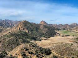
I usually run the Deer Leg trail in the opposite direction and was a little surprised when I happened upon the Lake Vista Trail. How had I managed to run past this trail junction so many times and not notice it? Any trail with “Vista” in the name is worth exploring, so there was little choice but to turn onto the trail and see where it led.

Malibou Lake and Sugarloaf from Lake Vista Ridge

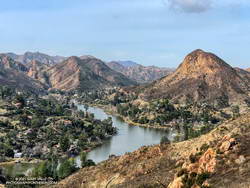
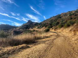
As it climbed toward an obvious ridgeline, the enjoyable single-track trail wound in and out of several small canyons. About 0.7 mile from the Deer Leg Trail junction, the Lake Vista Trail topped out at a very pretty overlook of Malibou Lake (not a typo). My watch showed the mileage to the overlook from the Cistern Trailhead was about 2 miles.

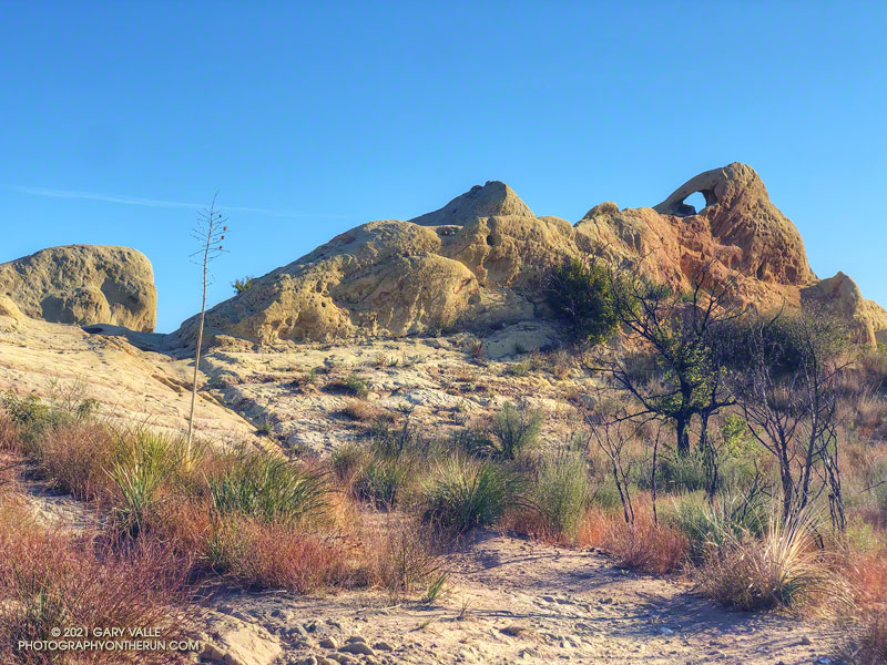
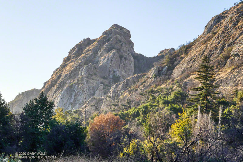
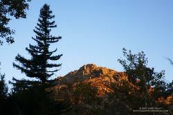
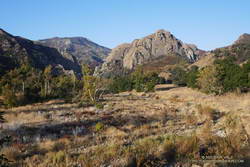
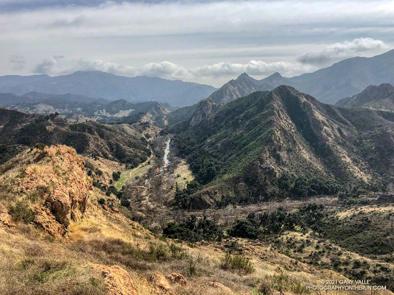
From the overlook an unofficial “use” trail worked back east along a broad ridge to the top of a prominent butte that has an unique exceptional of Malibu Creek, Century Lake and Goat Buttes. Because of the area’s volcanic origins, the use trail is rough and rocky in places, and the trail is not always obvious. It’s a little under a half-mile from the overlook to the summit of the butte. Even though it was Winter, I kept a wary eye and ear out for rattlesnakes.

Once back at the overlook, I made a loop of it by descending the Lake Vista Trail to the Reagan Ranch parking area, and then working back east on the Yearling and Lookout Trails to the Cistern Trail. Here’s an interactive, 3D terrain view of my GPS track of the run and hike.

A Sandstone Mammoth and a Spiral Labyrinth on the Bulldog Loop

A natural sculpture of a sandstone mammoth on the Backbone Trail

Updated June 26, 2023. The spiral has been periodically removed and rebuilt over the years. Google Earth historical imagery shows that it was removed sometime between March 2021 and February 2022. As of June 25, 2023, it had not yet been rebuilt.

Instead of struggling to escape a tar pit, this “mammoth” seems to have been caught up in 25-30 million-year-old sandstone.

The beast can be seen along the Backbone Trail, east of the Corral Canyon Trailhead. When running/hiking/riding east from the trailhead, the trail climbs over two steep steps and up to gap in the rock. In the photo above, the gap is on the left and the mammoth figure is on the right. From the gap, the trail descends a rock corridor to Mesa Peak fire road.

A closer look at the mammoth reveals that it is pockmarked and there are rocks embedded in the sandstone. The embedded rocks are cobble from an ancient river and the pockmarks are where rounded rocks have fallen out of the eroding sandstone.

Spiral labyrinth constructed of ancient stream cobble along the Backbone Trail
Spiral labyrinth along the Backbone Trail

Stream cobble that has eroded out of sandstone formations in this area has been used to construct a spiral labyrinth on the north side of Mesa Peak Fire Road. The cobble was tumbled and smoothed by streams that drained a range much older than the Santa Monica Mountains.

The title photo is from this morning’s run of the Bulldog Loop.

Some related posts: Moon and Sycamores, Malibu Creek State Park; Bulldog Loop Near Corral Canyon

Moon and Sycamores, Malibu Creek State Park

Moon and Sycamores, Malibu Creek State Park

The photograph Moon and Sycamores was taken at dawn, near Malibu Canyon and Piuma Road, at the start of this morning’s Bulldog Loop trail run in Malibu Creek State Park.

A quarter-mile from the top of Bulldog Mtwy fire road in Malibu Creek State Park.
A quarter-mile from the top of the Bulldog climb.

According to the Tempe sensor on my pack, the temperature ranged from a chilly 32° F along Malibu Creek to around 65° F on the crest. It was a near perfect morning to be outdoors.

Here’s an interactive, 3D terrain view of my GPS track from a previous run of the Bulldog Loop from Malibu & Piuma.

Some related posts: Bulldog Loop Plus the Phantom Loop; Trees, Bees, and a Washed-Out Footbridge on the Bulldog Loop in Malibu Creek State Park; After the Woolsey Fire: Bulldog Loop

Bulldog Loop Plus the Phantom Loop

Marine layer clouds from the Backbone Trail at
Marine layer clouds from the Backbone Trail at “Mammoth Pass.”

The Bulldog Loop, without any extras, is a little over 14 miles long, with an elevation gain of about 2700′.

While doing the Phantom Loop last week, I was reminded that a good way to extend the Bulldog Loop is to combine it with the Phantom Loop. This produces a run of about 19 miles, with an elevation gain of around 3650′.

Early morning view of Saddle Peak from the Cistern Trail

This weekend I was looking to do something a little longer. With the National Forests in Southern California still closed, the usual high country options weren’t available. The temperature forecast looked warm, but not crazy hot, so it was a good day to do this run.

The Cistern/Phantom Trailhead on Mulholland Highway is a convenient place to start and end the loop. Later in the run, water is usually available from a faucet and fountains adjacent to the restrooms at the main MCSP parking lot. If doing the loop counterclockwise from the Cistern Trailhead, the restrooms and water are about 14 miles into the run.

Santa Monica Mountains from the top of the Bulldog climb.

The main attraction is still the Bulldog climb. From Crags Road to Castro Mtwy, the Bulldog Mtwy gains about 1730′ over about 3.4 miles. From the MCSP parking lot to the high point on the Phantom Trail, the route gains a bit more than 1000′ over 4.7 miles.

Here’s an interactive view of the merged 19 mile loop. A longer variation continues on the Grasslands Trail to De Anza Park and returns to Liberty Canyon on the Talepop Trail.

Crest of the Santa Monica Mountains from the Phantom Trail

Some related posts: Redwoods, Raptors, and the Phantom Loop; Trees, Bees, and a Washed-Out Footbridge on the Bulldog Loop; Best Trailhead to Start the Bulldog Loop?

Redwoods, Raptors, and the Phantom Loop

Coast redwood near Century Lake in Malibu Creek State Park
A coast redwood stands above the other trees near Century Lake.

It was a chilly 45°F as I crossed algae-covered Malibu Creek on a foot-worn log. Following a brutally hot Summer with temps in the West San Fernando Valley reaching 121°F, the chill of the cold air felt especially good.

The plan was to do the Phantom Loop, but first, I was going to run over to the Forest Trail. The side trip was not only to check on the coast redwoods along the trail but to enjoy the calm beauty of the area. To say 2020 has been unsettling is like saying a rattlesnake bite is a little annoying — and the year isn’t over yet.

Coast redwood near the Forest Trail and Crags Road junction in Malibu Creek State Park
Coast redwood near the Forest Trail and Crags Road junction

After crossing the creek, I stopped to photograph the redwood near the junction of the Forest Trail and Crags Road. The sun had just risen, and behind the tree, orange-tinted sunlight illuminated the rocky ridge above the M*A*S*H site.

Continuing along the Forest Trail toward Century Lake, I counted four healthy-appearing redwoods and two struggling trees. Redwoods sometimes grow in a group of two or more trees, and these were counted as a single “tree.” Near the end of the trail is a naturally-germinated redwood that has grown to about 5.5 inches in diameter. Remarkably, this young tree survived the 2011-2015 drought and the 2018 Woolsey Fire, and appears healthy!

I had just finished photographing the young tree when a Cooper’s or Sharp-shinned Hawk flew from a nearby oak and through the trees along the trail. It landed on the limb of an oak ahead of me but was in deep shade. In a much-enlarged image, the bird looks like a Sharp-shinned Hawk, but distinguishing the two species can be challenging.

Red-tailed hawk atop a coast redwood in Malibu Creek State Park.
Red-tailed hawk atop a coast redwood.

A few yards down the trail, a much larger raptor — a Red-tailed hawk — was perched at the top of the tallest redwood. The huge bird had its wings pulled back to expose more of its body to the warming sun. It looked like a giant penguin sitting atop a tree. As I approached, it began to preen its feathers, comfortable with its lofty position.

With a sigh, I left the Forest Trail behind and returned to Malibu Creek. This time I crossed the creek on a plank near the washed-out bridge. This was a more direct route than the fallen tree upstream but only worked because the creek was low. At the crossing, a passing runner asked if he was on the Bulldog Loop. I assured him he was and was a little envious that he was getting to experience that excellent run for the first time.

Morning view of Goat Buttes in Malibu Creek State Park
Morning view of Goat Butte and stream course of Malibu Creek

As usual, Crags Road and the High Road were busy thoroughfares. The easy running under the sprawling coast live oaks was pleasant, and the morning view of Malibu Creek and Goat Buttes outstanding.

In a few minutes, I’d reached Mulholland Highway and then followed the Grasslands Trail to the Liberty Canyon Trail. From Liberty Canyon, the Phantom Trail gains about 750′ in elevation over about 1.5 miles to a high point and ridgeline with excellent views of Saddleback Peak, Las Virgenes Canyon, Brents Mountain, Goat Buttes, Castro Peak, Ladyface, and Boney Mountain.

The air quality this morning hadn’t been too bad. From up on the ridge, I could see there was far less smoke to the west of Las Virgenes Canyon than to the east. Yesterday, I’d done a run in the eastern Santa Monica Mountains and had to cut the run short because of smoke. That wasn’t a problem today, and the run had been a good one.

Some related posts: Coast Redwoods Along the Forest Trail, Urban Highlands, Saddle Peak from the Phantom Trail