Category Archives: trails

Boney Mountain North Side Loop

Airy summit on the western ridge on Boney Mountain`s north side.

The posts Boney Mountain – Big Sycamore Canyon Circuit and Boney Mountain Western Ridge & Loop describe two routes that ascend the north side of Boney Mountain — a circuitous eastern ridge route, and a more difficult western ridge.

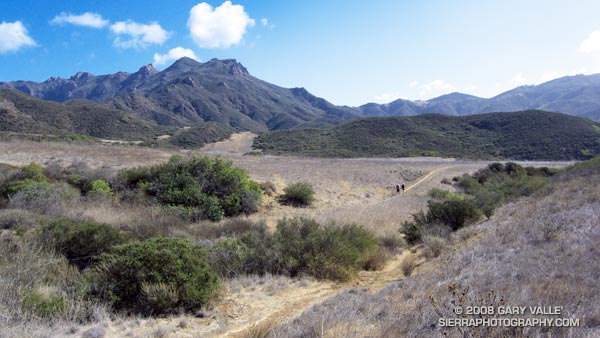
These two routes can be combined into an adventurous loop that starts and ends at the junction of Danielson Road and the Old Boney Trail. The loop, with no side trips, works out to about 4 miles. Add in the 2.5 mile approach from the Wendy Drive trailhead, and the total distance for the course is about 9 miles, with an elevation gain of a bit over 2000 ft.

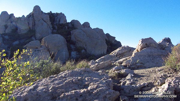
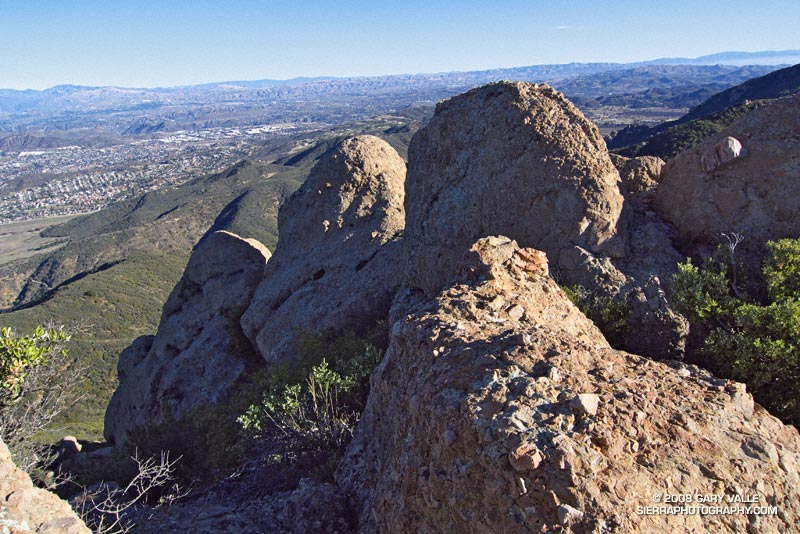
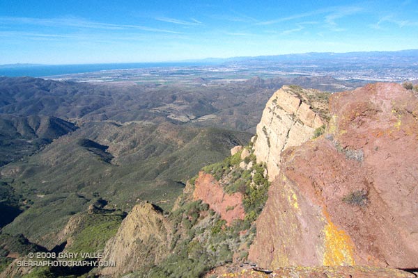
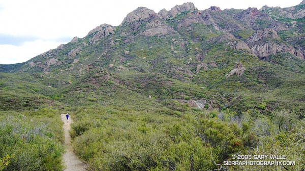
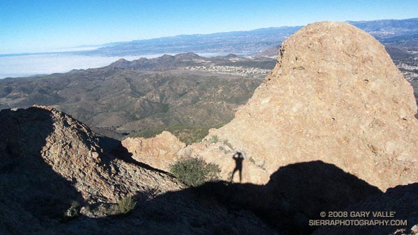
I did the loop counterclockwise — up the western ridge and then down the eastern. The New Year’s weather could not have been better. Dense fog clung to the coast, but a brisk offshore breeze kept inland views crystal-clear. On the way up the western ridge I couldn’t resist doing a short detour to climb one of the crag’s appealing summits.

At the top of the western ridge, I briefly debated doing Tri-Peaks and Big Dome, but was hoping to make it home by noon, so skipped those side trips.

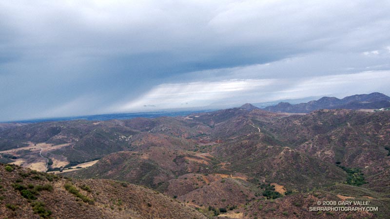
With gravity on my side, the run down the eastern ridge was not nearly as gnarly as I thought it might be. I was running in Inov-8 Roclite 305s — nimble shoes with a fell running heritage. Mine weigh only 21.1 oz./pair (US 9.0) and were particularly well-suited to the rough terrain.

This climb and adventure run was a great way to start the New Year — and I did make it home in time for lunch with my wife!

Here’s a Google Earth image of a GPS trace of my route.

Boney Mountain Western Ridge & Loop

Part way up the western ridge route on Boney Mountain's north side.

Two routes are commonly used to climb the rugged north side of Boney Mountain. One route ascends a ridge to the east of the Danielson cabin site, and the other a rocky ridge to the west of the site. Today, I was planning to do the western ridge, and then continue up and over Tri-Peaks to the Chamberlain segment of the Backbone Trail.

The day was chilly. In the deep shadows along Danielson Road, puddles of water were frozen, and frosty soil crunched underfoot. Shadow turned to sun at the turnoff to the cabin site, and I paused for a moment to enjoy the warm sunshine and gaze at the rocks towering above Danielson’s canyon. This impressive formation straddles the western ridge and I wondered just how spectacular the crags would be.


Crags on the western ridge route of Boney Mountain.
Spurred by a small surge of adrenalin, I turned and continued up the Old Boney Trail. From its highpoint I followed a use trail to the top of benchmarked “Hill 1918.” The first big outcrops loom above this point, and they mark the start of the more challenging part of the western ridge.

Although some sections were a bit overgrown, the route was fairly well defined. Despite appearances, there was no significant bushwacking, and only a little scrambling up, or across, short sections of low angle rock. By usual mountaineering standards the climbing was not difficult — class 2 to marginal class 3 — but some skilled route finding is required. It was fun finding my way through the imposing outcrops of angular and pocketed Conejo volcanic rock.


Pt. Mugu State Park, the Channel Islands, Oxnard Plain, and the mountains of Ventura and Santa Barbara
Higher on the ridge the route played tag with the edge of the precipitous cliffs of the Boney Mountain escarpment. At various points there are craggy views of Pt. Mugu State Park, the Channel Islands, Oxnard Plain, and the mountains of Ventura and Santa Barbara. Eventually, the route emerges from a steep thicket of red shanks at a small saddle north of Tri-Peaks.

From here, I continued to Tri-Peaks and was soon enjoying the superlative downhill of the Chamberlain Trail. This time, instead taking one of several routes down to Big Sycamore Canyon, I looped back on the Old Boney Trail to the start of the climb. From here I retraced my route on the Danielson Road back to Satwiwa and the Wendy Drive trailhead.

The course worked out to about 16 miles with an elevation gain of over 4000 ft.

Some related posts: Boney Mountain – Big Sycamore Canyon Circuit – Coyote Trail Variation, Clearing Clouds on Boney Mountain

Twenty-Two Miles and Two Classic Climbs

The West Fork San Gabriel River at the Rincon-Edison road crossing.

We stopped for a few moments at the river crossing, where water stood in pools waiting for Winter rain. Instead, cold air flowed down its course, cool and refreshing. From this point there would be little shade. Rarely cold, the climb out from the West Fork San Gabriel River to Shortcut Saddle is often warm, and sometimes debilitating.

Miklos, Krisztina and I were doing the Shortcut Saddle – Mt. Wilson loop — an approximately 22 mile loop that includes two memorable climbs from the Mt. Disappointment 50K and 50M runs. The loop also incorporates the Rim Trail, an adventurous trail that is rough, steep, and washed out at points, but also includes long stretches of excellent trail running. The route starts with almost four miles of downhill on the the Silver Moccasin Trail — a good warmup and a great way to start a trail running day.

Thankfully, today the weather was cool and the Fall shadows long. This translated to more running and a faster pace up Rincon-Edison road. Even so, we were happy to reach the point where the Silver Moccasin Trail shortcuts the last long switchback of the road, and followed this more direct route up to the trailhead.

Our variation of the climb from the W.F. San Gabriel River to Shortcut Saddle on the Rincon-Edison Road was about 5.6 miles long, with an elevation gain of about 1925 ft.  The climb from the W.F. San Gabriel River at West Fork campground up the Gabrielino and Kenyon DeVore trails to the Mt. Wilson parking lot worked out to about a 2550′ elevation gain in 5.2 miles. The total elevation gain for the loop is about 4500′.

Related posts: Angeles High Country, Mt. Disappointment 50K 2008 Notes

Fossil Trail – Pt. Mugu State Park

Shell impressions on the Fossil Trail in Pt. Mugu State Park.

The Fossil Trail is a steep, approximately mile-long trail in Pt. Mugu State Park that connects the Upper Sycamore Trail, near its junction with Sycamore Canyon Road, to the Old Boney Trail. The most obvious fossils are shell impressions and remnants found in an exposed layer of sandstone about a tenth of a mile below the Old Boney Trail junction. Some of the shell impressions are palm-sized and larger.

The shells appear to be a type of cockle (Anadara devincta) that is an indicator of Miocene-age formations. (See the Oregon Sea Grant publication “Fossils You Can Find on Oregon Beaches.“)  In this case, the fossil exposure appears to be in the Lower Topanga Formation, which is believed to have been formed in the middle to early Miocene, about 20 million years ago.

The shape, thickness and ribbing of this type of shell increases its strength and resistance to crushing — improving the shell’s chances of remaining intact when buried in sediment, and during subsequent geologic processes. This may be one of the reasons it is a prevalent indicator fossil.

The photograph is from Sunday’s run from Wendy Drive to Serrano Valley.

Serrano Valley from Wendy Drive

Descending to Serrano Valley in Pt. Mugu State Park

Scruffy clouds clung to the mountain ridges and summits, confirmation that a weak cold front was moving through the area, cooling temperatures and stirring up the wind. The forecast for the Santa Monica Mountains National Recreation Area had mentioned 25 to 35 mph winds with gusts to 60 mph. So far the weather in Pt. Mugu State Park had been nearly perfect — breezy and little chilly, but without the impenetrable winds that can take all the joy out of running.

Earlier we had climbed the Fossil Trail, a steep mile-long trail that connects the Upper Sycamore Trail, near its junction with Sycamore Canyon Road, to the Old Boney Trail. With only a few weeks remaining to the Solstice, shadows in the canyon were long and the light wintery. I thought we might have missed the fossils, but we happened on a nice exposure about a tenth of a mile below the Old Boney Trail junction.

About 5.5 miles later, we turned off the Old Boney Trail and descended to the rolling grasslands of Serrano Valley, another “must see” area of the Santa Monica Mountains.

Located on the east side of Big Sycamore Canyon, Serrano Valley is a more rugged counterpart to La Jolla Valley, just three miles to the west. Overseen by the castle-like summits of Boney Mountain, its vistas have a roughhewn edge, reminiscent of the most wild areas of the western U.S.

Here is a Google Earth image and Google Earth KMZ file of a GPS trace of our approximately 19 mile route to Serrano Valley and back to Wendy Drive.

Related posts: La Jolla Valley & Mugu Peak from Wendy Drive, Fossil Trail – Pt. Mugu State Park

T-storms and Trail Work

Old Boney Trail in the Boney Mountain Wilderness

When I woke to the rumble of thunder, rain pounding the roof, and wind roaring in the trees, I wondered if a planned run of the Boney Mountain Half Marathon course with John Dale was going to turn into an epic. Radar and satellite imagery showed subtropical moisture streaming in from the southwest, producing bands of showers and thunderstorms. Things don’t always look as bad at the trailhead as they do on weather radar, so I grabbed my gear and headed for Wendy Drive.

The weather looked promising driving through Agoura, but the further west I drove, the more ominous the skies became. Somewhere around Lynn Road KNX announced that the NWS had issued a severe thunderstorm warning for the Santa Clarita area, with cloud to ground lightning, heavy rain, possible damaging winds and dime-sized hail. It was with that thought in mind, and a shower pelting the car, that I pulled into the parking area on Potrero Rd.

If anything, weather is fickle, and sometimes that quirkiness can work for you. There was an area of heavy rain to the west, but the activity appeared to be skirting the area, so we opted to start the run.


Thunderstorm marching northeast from the Santa Barbara Channel across the Oxnard Plain.
There were a few sprinkles as we jogged down the blacktop into Big Sycamore Canyon, and a few more as we did the first easy mile of the Hidden Pond Trail. Down in the canyon it was hard to tell what the weather was doing, but after gaining some elevation we reached a better vantage point. Just a few miles away thunderstorms were being swept northeast from the Santa Barbara Channel, across the Oxnard Plain, and into the Ventura Mountains.

Skies darkened and the shower intensity increased as we ran down Ranch Center Fire Road. The wind was blowing in the fitful gusts that precede a thunderstorm, and it felt as if the sky might fall at any moment. With a slight shift in the track of the thunderstorms we might be running in a deluge, dodging lightning strikes.

But it didn’t shift. Following the shower, the sun broke through the clouds just long enough to add glints to the raindrops dripping from the leaves of sycamores and oaks in Blue Canyon. Under overcast skies, we climbed up the Old Boney Trail and into the Boney Mountain Wilderness.

We had not seen a hiker, runner, or rider since turning onto the Hidden Pond Trail early in the run. So it was a bit of a surprise when we rounded a corner and ran into Ed Reid and several other volunteers with the Santa Monica Mountains Trails Council doing trail maintenance on a section of the Old Boney Trail.

Just about any weekend of the year, dedicated members of the SMMTC will be somewhere in the Santa Monica Mountains, working on a trail. To get a better idea of the amount of work done and the number of trails involved, take a look at this list of recently maintained trails! How many of these have you hiked, run or ridden?

There are several ways to help support SMMTC:

  • Volunteer to do trail maintenance.
  • Join the SMMTC.
  • Make your REI purchases using the REI link on the SMMTC web site. REI will donate a percentage of the purchase to SMMTC.

See the Santa Monica Mountains Trails Council web site for more info.

Some related posts: Boney Mountain Half Marathon, Return to Hidden Pond