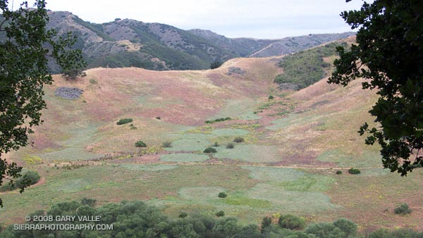
View of Grasslands and Talepop trails in Malibu Creek State Park from the Las Virgenes View Trail. The Talepop Trail is on the ridge in the middle distance. The Grasslands Trail runs along the base of the hill.

View of Grasslands and Talepop trails in Malibu Creek State Park from the Las Virgenes View Trail. The Talepop Trail is on the ridge in the middle distance. The Grasslands Trail runs along the base of the hill.
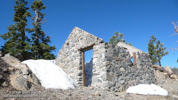
Along with the Chumash Trail to Rocky Peak Rd., the Secret Trail to Calabasas Peak is one of my favorite local short trail runs. The two mile route to the peak is a mix of single track and dirt road that gains about 750′ in elevation.
The trail winds its way through shaded ravines, dense chaparral and sandstone outcrops to Calabasas Peak Motorway. This fire road is followed south about half a mile to a use trail (on the right) that follows a ridge to the summit. It’s also possible to continue higher up the road and access the summit from the south. There is a survey marker (actually two) on the summit.
Here’s a Google Earth image showing the summit area, and a Google Earth KMZ file of a GPS trace of my route.
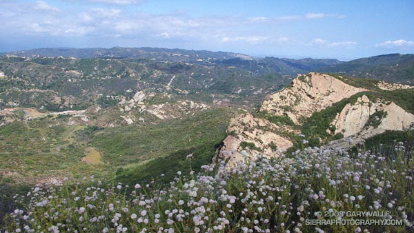
Calabasas Peak Motorway continues down to Stunt Rd. and connects to the Stunt High Trail and points beyond. Here’s what Calabasas Peak looks like from the Backbone Trail near Saddle Peak.
Related posts: Tapia Bound, A Long Run Kind of Day
When considering where I might run this weekend, the words “snow” and “altitude” had a certain appeal. Record high temperatures had been set in the Los Angeles area on Friday and Saturday, and there was little doubt that more temperature records would fall today.
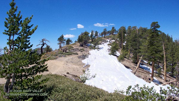
A couple of weeks before I had dodged a few remnant snow drifts on Pleasant View Ridge. From that vantage point you could see that there was much more snow on the steep, north facing slopes along the ridge between Mt. Islip and Mt. Baden-Powell. The S-shaped ridge spans a distance of several miles and links five peaks over 8000 ft: Mt. Islip, Mt. Hawkins, Throop Peak, Mt. Burnham, and Mt. Baden-Powell. Two of the peaks, Mt. Baden-Powell and Throop Peak, exceed 9000 ft. Today, the plan was to do these five peaks as part of an approximately 17 mile out and back route from Islip Saddle, enjoy the snow before it melted, and try to escape the triple digit temps of the lowlands.
Logistically, the difficult peak is Mt. Islip. While the other peaks can be done with relatively minor deviations from the trail, Mt. Islip stands alone, more than a mile from the PCT at Windy Gap. This time I opted to climb Mt. Islip from Islip Saddle via the northwest ridge. I’ve been investigating stunted Jeffrey and Sugar pines found along the windswept ridges of the San Gabriels, and this direct approach would give me the opportunity to check out more trees.
That was this morning, now I was on by way back from Mt. Baden-Powell, and about a quarter-mile east of Throop Peak. Hot, thirsty, dispirited, and nearly out of water, I had stopped to dig into the side of a dirty snowbank– attempting to get to snow that at least looked clean. The air temperature was eighty-something, but my fingers were stinging with cold as I scooped the coarse crystals into my Camelbak.
It’s amazing what a few sips of chilled water and an icy cold pack against your back can do for your demeanor. A few minutes before I had been debating whether I should just skip Throop Peak and Mt. Hawkins, and get down to Little Jimmy Spring ASAP. Now I could do these peaks and continue to enjoy a very warm — but beautiful — day in the San Gabriel Mountains.
Here’s a Google Earth image and a Google Earth KMZ file of a GPS trace of my route. GPS reception was poor climbing the ridge to Mt. Islip.
Related post: Snowless San Gabriels
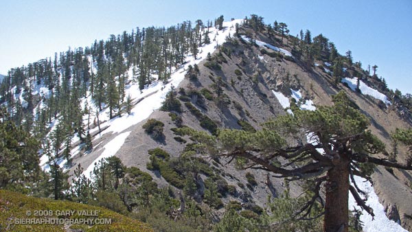
A small patch of snow crunched under foot as I worked my way west along Pleasant View Ridge. Overnight the temperature had dropped below freezing, and careful route-finding was required to work around icy patches of steep snow clinging to the ridge. In other years this might be tedious, but after last year’s parched Spring, it was enjoyable to have to wind my way through the maze of rocks, trees, chinquapin and snow.
Most of the snow could be avoided by staying on the sunny side of the ridge. but in a couple of places it was easier to drop down and around large patches of snow on the north side of the ridge. The snow was rock hard, and I wondered if the descent from the highest point along the ridge was going to be a problem. There was little doubt that the north slope of peak 8248 would be snow covered. If the snow extended to the northwest ridge and face, I might have to turn back.
Fortunately, as the photograph above shows, most of the ridge was free of snow, and I was able to continue on the loop. It was great to have snow on the peaks and water in the creeks!
Related posts: Pleasant View Ridge, Peaks Along Pleasant View Ridge
Google search: $g(Pleasant View Ridge), $g(trail running), $g(San Gabriel Mountains)
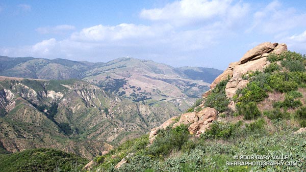
View across Blind Canyon to Oat Mountain from the Rocky Peak fire road. At one time slated to become a Los Angeles County landfill, Blind Canyon is now part of Rocky Peak Park.
From an out and back run on Rocky Peak Road to the top of the Chumash Trail.
Related post: San Fernando Valley from Rocky Peak
Google search: $g(Rocky Peak), $g(Blind Canyon), $g(landscape photography)
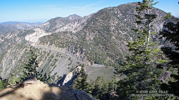
I was headed home from a whitewater slalom training camp on the Kern River, and wanted to take advantage of being in the Southern Sierra and run an unfamiliar section of the Pacific Crest Trail.
Yes, it was windy and there were lenticular clouds in the lee of the Sierra, which meant it might get REALLY windy. No, I didn’t have my regular trail shoes or a hydration pack. Yep, there was some snow on the north side of the peaks on either side of the highway.
The plan was to do an out and back run north on the PCT from Hwy. 178 at Walker Pass (5250′). I didn’t know how far. I hoped far enough to check out the approach to Owens Peak. But that would depend on the amount of snow on the trail, how cold and windy it became, and how much elevation gain my legs had left in them.
It might not seem that paddling a kayak would be hard on the legs, but your legs are your primary connection to the boat, and my legs were worked following several days of strenuous paddling.
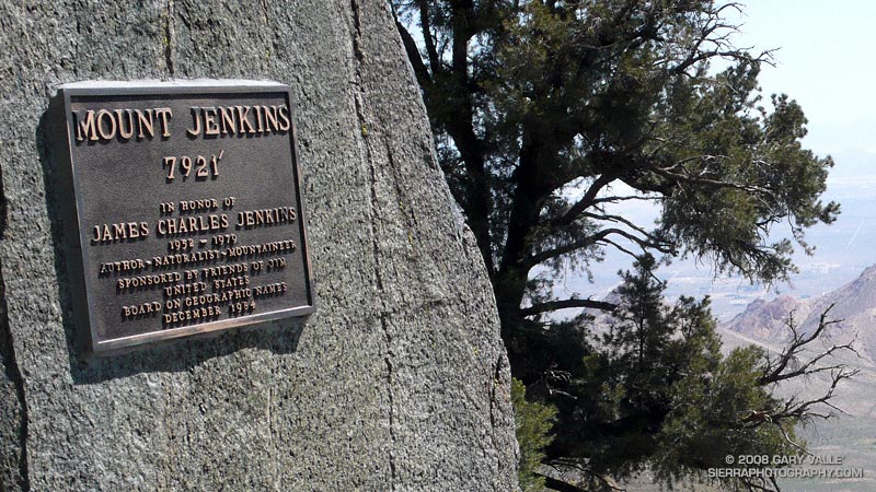
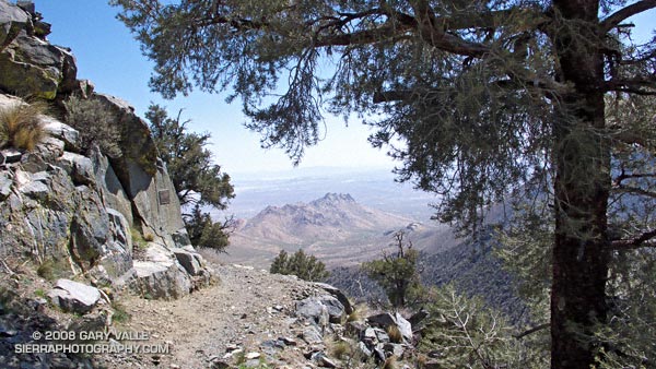
This post’s photograph was taken about five miles into the run. The plaque commemorates the naming of Mt. Jenkins. It honors J.C. Jenkins, whose Exploring the Southern Sierra and Self Propelled in the Southern Sierra books have inspired many an adventure. It was placed where the south ridge of Mt. Jenkins intersects the PCT.
I continued a mile and a half to a point where I could see the saddle and ridge leading to the summit of Owens Peak. Rounding a corner, I emerged from a wind protected traverse, and was slammed with a cold gust of wind. Ahead, I could see another long stretch of snow covered trail. Owens Peak would have to wait…
Notes: There’s an automated weather station at Walker Pass. This hill of wildflowers was a short distance from the pass.
Google search: $g(Southern Sierra), $g(Pacific Crest Trail), $g(PCT), $g(trail running)