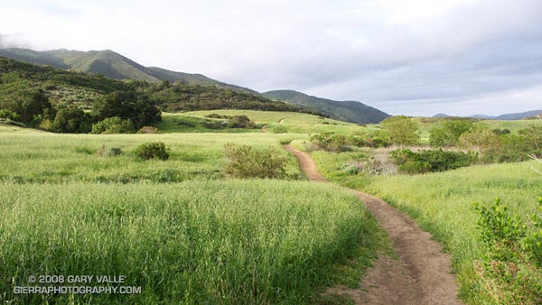
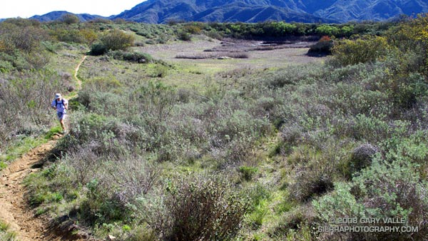
A segment of the Satwiwa Loop Trail at Rancho Sierra Vista/Satwiwa in Newbury Park, California.
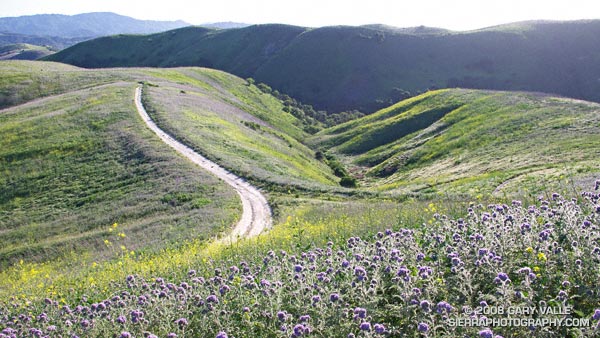
From Sunday’s run/hike over Boney Mountain.
Google search: $g(landscape photography), $g(trail running)

A segment of the Satwiwa Loop Trail at Rancho Sierra Vista/Satwiwa in Newbury Park, California.
From Sunday’s run/hike over Boney Mountain.
Google search: $g(landscape photography), $g(trail running)
The Cheeseboro Ridge keyhole loop is a slightly shorter variation of the Ahmanson – Cheeseboro Canyon keyhole loop described in the post Classic Cheeseboro Canyon. Since it ascends the Cheeseboro Ridge Trail, instead of descending Cheeseboro Canyon, the ridge route has a bit more elevation gain.
Cheeseboro Ridge separates Las Virgenes Canyon and Cheeseboro Canyon and on a clear day the views are outstanding. Running the ridge is particularly enjoyable in the Spring when temps are cool and the hills are green. In the heat of summer, the surface of the road develops a powder-like layer of silty dust and the experience isn’t nearly so pleasant.
If starting at the Victory Trailhead of Upper Las Virgenes Canyon Open Space Preserve, the length of the run is about 12.75 miles with an elevation gain and loss of about 1600 ft. Here are a Google Earth image and Google Earth KMZ file of a GPS trace of the route, and links to trail maps for Upper Las Virgenes Canyon Open Space Preserve and Cheeseboro/Palo Comado Canyons.
The beauty and intensity of the day was infectious. Hours before a cold low pressure trough digging down from the Pacific Northwest had carried showers, thunder, hail, and chilly temps into Southern California. Its rainfall had refreshed the greens of the hills, and accentuated the yellows, purples and reds of the wildflowers along the trail. Its blustery winds had cleansed the sky.
A few minutes before I had completed one run, and now was starting another. I wasn’t certain how much farther I would run — I just knew I had to run.
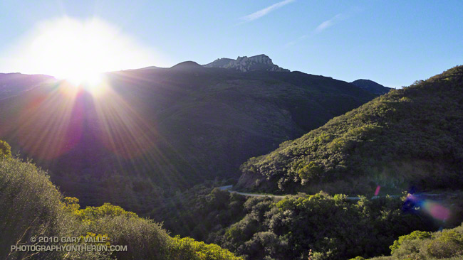
The day had begun with friends on the Secret Trail in Calabasas. We had run up and over the shoulder of Calabasas Peak, and then ascended Saddle Peak via the Stunt High Trail and Backbone Trail. The view from the summit of Saddle Peak had extended beyond Santa Monica Bay and Palos Verdes Peninsula to the South Bay and Saddleback Mountain. New snow glistened on Mt. Baldy, and to the west the rocky summits on Boney Mountain stood in bold relief.
That 14.5 mile run had ended at Tapia Park. Now I was on the Tapia Spur Trail on the first climb of the Bulldog Loop. On the wind sheltered slope the bright yellow blossoms of tree poppy had begun to unfurl, absorbing the warmth of the midday sun. Distant peaks loomed to within an arm’s reach, and my legs seemed to draw energy directly from the trail. It was a long run kind of day.
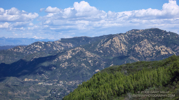
Notes: The title photograph is of Saddle Peak from the Backbone Trail, in the Santa Monica Mountains, near Los Angeles. Mt. Baldy can be seen in the distance. The combined length of the runs was about 29 miles with an elevation gain of about 5000 ft.
Some related posts: Tapia Bound, Bulldog Loop and the Corral Fire, Fog Along Malibu Creek
When the rainy season turns wet and the grasses green, all routes to Simi Peak are scenic, but the varied trails and terrain, and the wilderness feel of the more remote sections of this 21.5 mile run makes it one of my local favorites.
It is a longer variation of the route described in the post Upper Las Virgenes Canyon Backcountry. The run starts at the Victory (or Vanowen, or Las Virgenes) trailhead of Upper Las Virgenes Canyon Open Space Preserve and explores the headwaters of Las Virgenes Creek. At the junction of the power line service road and “backcountry” trail, instead of turning south up the power line service road, this option works west over to Albertson Motorway fire road, and on to China Flat and Simi Peak.
Here’s a Google Earth image and Google Earth KMZ file of a GPS trace of the route.
Southern California can have inclement Winter weather. This January downtown Los Angeles experienced a streak with 8 days of measurable rain, and last year temperatures in the suburbs plunged to a frigid 20°F. Maybe this doesn’t compare to Seattle’s 2005-2006 rain streak of 27 days, or International Falls’ recent record low of 40° below zero, but it qualifies as rainy and cold none the less.
Today it was not rainy and cold. It was just about as pleasant as a day could be. Skies were blue, winds were light, and the temperature was in the mid-seventies. Starting at the Wendy Dr. trailhead on Potrero Rd., we enjoyed the perfect weather by doing a 14.5 mile variant of the Boney Mountain Half Marathon Course.
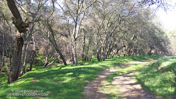
The photograph above is of the Hidden Pond Trail near Hidden Pond — recently restored by Winter rains.
Related posts: Boney Mountain Half Marathon, Big Sycamore Canyon Circuit, Boney Mountain – Big Sycamore Canyon Circuit
Every event has its own personality and character. The XTERRA Boney Mountain Half Marathon is a trail running classic, with superb single track trails, fantastic views, grueling climbs, and fast, fast downhills. The longer climbs are on the single track sections of the course, and the descents generally on roads or old road beds. This results in a challenging course with 2600′ of elevation gain/loss, that — for the fleet-footed — can be very fast.
There are two significant climbs. The big one starts in earnest around mile 6.8 on the Old Boney Trail. This is a little less than a mile past the Danielson aid station. From the low point on the course (295′) in Big Sycamore Canyon at mile 5.5 to the high point of the course (1820′) at mile 9.75, there is a gain of about 1700′ and loss of about 175′ in elevation.
The Old Boney climb is tough, no doubt. But you have to be careful not to overlook the nearly 700′ of climb (and a little downhill) between mile 1.8 and mile 4. Early in the race, full of energy and charged with endorphins and adrenaline, it’s easy to push this section too hard. Runners tend to be more tightly grouped, and a dynamic develops that pushes the pace.
I managed to avoid that trap, and other than slipping at the first creek crossing and almost diving for mud snails, my race went reasonably well. The group of runners I tended to be around were upbeat and experienced, and everyone seemed to be enjoying the day. The weather was about as good as it gets for a race — cool and clear and without much wind. The trail was still damp from heavy rain earlier in the month, but there was almost no mud.
I took a water bottle and 3 GUs and skipped most of the aid stations. In my case I think this saved time, and I stayed better hydrated than if I had run without a bottle.
This year’s overall winner, Jonathan Toker, flew through the course in 1:36:30, averaging 7:22 minute miles! The overall Women’s winner was Julie Jakoboski with a time of 1:54:05. Full results can be found on the Boney Mountain Trail Run web page. Many thanks to the crew at Generic Events, and all of the race volunteers, for a great race!
Here’s a Google Earth image and an interactive 3D terrain view of a GPS trace of the Boney Mountain Half Marathon course.
Sobering note: In 2006 Sal Bautista ran the course in 1:31:11, averaging 6:58 minute miles!