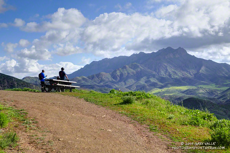
The Ray Miller Trailhead in Pt. Mugu State Park marks the western end of the Backbone Trail, a 68-mile scenic trail along the spine of the Santa Monica Mountains. The Ray Miller Trail’s long, winding descent into La Jolla Canyon is a favorite of runners and hikers, and a fitting end to those traversing the BBT from east to west.
My run this morning was to the Ray Miller Trailhead (and back) from Satwiwa, starting at the Wendy Drive trailhead in Newbury Park. The Wendy Drive Trailhead is very popular and is the starting point for many good runs, hikes and rides. To get an idea of the route options, see the detailed trail maps on the Pt. Mugu State Park page of VenturaCountryTrails.org.
Today I was looking to do a longer run, so didn’t take the usual route. On the way down Big Sycamore Canyon, I skipped the turns at Wood Canyon (Hell Hill), Wood Canyon Vista Trail (BBT) and Fireline Trail and at Overlook Fire Road, some eight miles into the run, finally headed uphill.
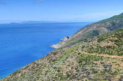
View of the Pacific, Anacapa Island and Santa Cruz Island from the Ray Miller Trail.
The top of the Ray Miller Trail is a stout 2.5 -mile climb from the bottom of Overlook Fire Road. Along the way there were excellent views of Sycamore Canyon, Serrano Valley and Boney Mountain.
About a half-mile down the Ray Miller Trail there is a popular overlook of the coast. The day was clear and there were stunning views of the Pacific and the Channel Islands. Brushed by whispers of wind, the cerulean blue Pacific filled my view for much of the descent to the parking lot.
It was an odd feeling to run down to the parking lot with runners who were cheerfully finishing their morning run, knowing that I had many more miles to go. After a quick stop at the water spigot, I turned, and sighed, and took the first steps back up the hill and toward Satwiwa.
The trail work schedule of the Santa Monica Mountains Trail Council (SMMTC) is impressive to say the least. According to their Trail Work Statistics page, in 2018 the SMMTC was responsible for over 4,300 person-hours of work related to “establishing, preserving and maintaining the public trail system throughout the Santa Monica Mountains and adjacent areas.”
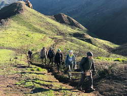
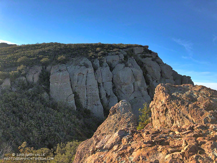
Some of the SMMTC crew approaching the junction of the Old Boney and Chamberlain Trails.
Saturday, 27 trail runners assisted the SMMTC in trail work on the Chamberlain Trail segment of the Backbone Trail. The trail runners were organized by Backbone Trail Utra race director Mike Epler, who recently joined the board of the SMMTC. Ultra race director Keira Henninger volunteered and also encouraged runners to participate.
The Chamberlain Trail took a hard hit from the Woolsey Fire and subsequent rains. Under the direction of SMMTC crew members, runners restored washed out and rutted sections of trail and removed burned limbs, rocks and other debris. The trail was restored from its junction with the Old Boney Trail up to Chamberlain Rock. In preparation for future trail work, hundreds of limbs were removed from the trail up to its junction with the Tri Peaks Trail.
Many runners ran to the Chamberlain Trail, did the trail work, and then ran back. This was a good way to get in a good long run and contribute to the restoration of the trails damaged in the Woolsey Fire.
During the later stages of the Woolsey Fire one of the big questions was how far west in the Santa Monica Mountains would it burn. Would it consume Pt. Mugu State Park only five years after the Springs Fire ravaged the area?
The answer to that question became far less clear following the big flare-up in the Sandstone Peak – Boney Mountain area on November 13, and the subsequent advance of the fire into the eastern part of Pt. Mugu State Park.
The Woolsey Fire was fully contained on November 21. A bit of good news in the midst of a whole lot of bad was that fire maps showed the north side of Boney Mountain and most of Pt. Mugu State Park had been spared. That’s what today’s outing was about — checking if the conditions on the ground on the north side of Boney Mountain and in Pt. Mugu State Park matched up to fire maps and data.
First up was the climb of Boney Mountain’s Western Ridge (Mountaineer’s Route) from Wendy Drive. Except for a little spillover along the crest at the top of the ridge, it was a relief to find that the Western Ridge route and its companion route, the Cabin Trail, were essentially unburned. Both of these routes are used to reach the popular high point along the crest that is generally regarded as “Boney Mountain.” The DEM-based elevation of this point is about 2935′. I enjoy climbing up the Western Ridge and descending the Cabin Trail, so it was good to know that option is still available.
While the north side of Boney Mountain didn’t burn, it was a different story to the south of the crest. The drainage between the top of the Western Ridge and Tri Peaks, and beyond, was badly burned. The last time this area burned was in the 1993 Green Meadows Fire, so the fuel load had been relatively high. From what I could see, the burn severity was generally on the high side of mid-range, but with patches of unburned, low, and more severely burned terrain.
In Pt. Mugu State Park aggressive firefighting and the effects of the 2013 Springs Fire generally — but not entirely — restricted the Woolsey Fire to areas that were not burned in 2013. Much of the Chamberlain Trail did not burn in 2013, and the Woolsey Fire followed this swath of 25-year-old growth westward, burning nearly all of the Chamberlain Trail, as well as the steep slopes to the north of the trail. About half of the large bowl forming Boney Mountain’s western escarpment was burned. As was the case after the Springs Fire, Blue Canyon could once again be at risk from flash floods and debris flows, should a heavy or extended rain event occur.
The westernmost tongue of the Woolsey Fire, near Blue Canyon, reached to within 0.5 mile of the Big Sycamore Canyon Road. For the most part, the fire was held east of the Old Boney Trail. There were several fire retardant drops along this front and the Old Boney Trail was cut into a firebreak/access route. It looked like the dozers came in from Serrano Road. It boggles the mind to think of the logistics required to move firefighting personnel and equipment into wildland areas.
The west side of Serrano Valley and Serrano Canyon turned out to be OK, although you could see where the fire had burned part of the valley and the southwest slopes of Boney Mountain.
Running north on Sycamore Canyon Road, other than the tracks of heavy equipment, there was little to suggest the extent of the devastation to the east. My route back to Satwiwa and Wendy Drive included the Two Foxes Trail, and Upper Sycamore Trail. Except for the Chamberlain Trail, a segment of the Old Boney Trail, and part of the Blue Canyon Trail, other trails and roads in Pt. Mugu State Park appeared to be unaffected by the fire.
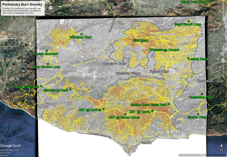
The initial burn severity estimate is based on a Burned Area Reflectance Classification (BARC) derived from satellite data before and after the fire. In the map above the burn severity classes are high (red), moderate (orange) and low (yellow). Note that areas within the fire perimeter that are not included in these classes may still have burned. Also note the fire was still burning when this assessment was made.
GPS tracks of the Backbone Trail and some other trails in the region have been added. Trail and placename locations should be considered approximate.
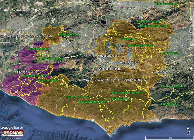
The Google Earth image above shows a recent perimeter for the 2018 Woolsey Fire along with GPS tracks of the Backbone Trail and some other trails in the region. The Hill Fire perimeter and 2013 Springs Fire perimeter (purple area) are also shown. Trail and placename locations should be considered approximate. Here is a larger version of the map.
The perimeter was was downloaded from GEOMAC and timestamped November 18, 2018 at 5:59 a.m. If the timestamp of the perimeter of the displayed map doesn’t match, try refreshing/reloading this page. The perimeter has been refined and the acreage is a slightly less than previously specified.
As of November 21, 2018 6:11 p.m., the Cal Fire Incident Page for the Woolsey Fire indicated that the fire had burned 96,949 acres and was 100% contained. The fire started on November 8, 2018 2:24 p.m.
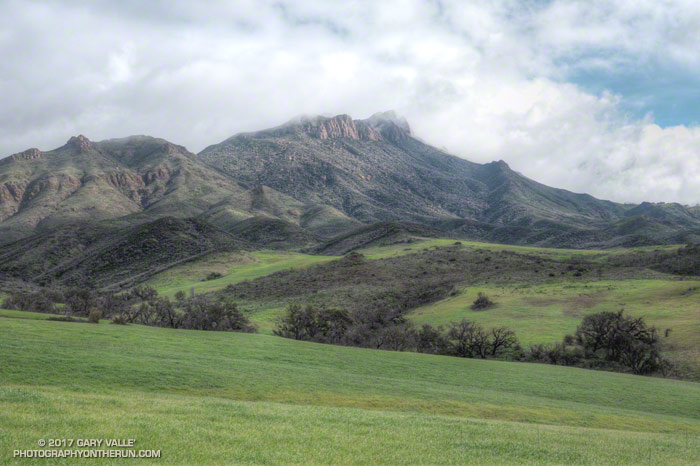
The misty rain had momentarily turned to sunshine. As I ran along the trail, rain-soaked sage glittered in a rainbow of colors. The peaks above me were still shrouded in gray clouds, but the sunlit valley below glowed bright and green. Streams that had been dry on New Years, now burbled and bubbled restlessly. My shoes and socks were soaked, not from stream crossings, but from the cold, wet grass overgrowing the trail.
Dense patches of shooting stars covered wet hillsides and milkmaids lined shady sections of trail. Paintbrush, Indian warrior, California poppies, larkspur, chocolate lilies, bladderpod, encelia, lupine, nightshade, wild hyacinth, phacelia, bigpod ceanothus and wishbone bush had also started to bloom.
The day not only encouraged the accumulation of miles, but of the sensations and emotions of the outdoor experience; and that feeling of well-being that emerges somewhere between the trailhead and the top of the last climb.