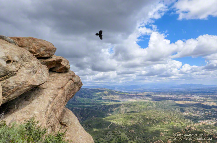
From a run and hike to the summit of Rocky Peak on March 21, before the MRCA/Santa Monica Mountain Conservancy closures.

From a run and hike to the summit of Rocky Peak on March 21, before the MRCA/Santa Monica Mountain Conservancy closures.
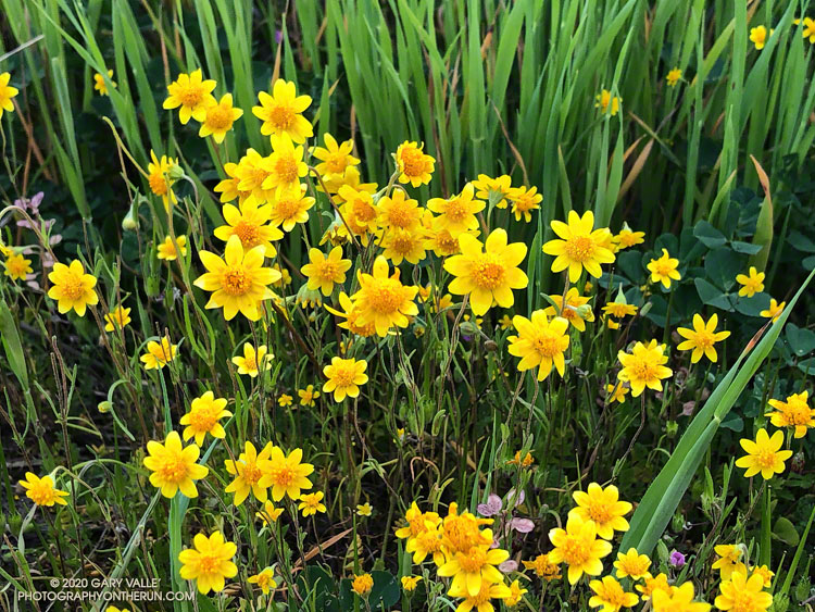
Goldfields are tiny wildflowers, but their bright yellow color more than makes up for their diminutive size.
Goldfields bloomed a little early on Lasky Mesa this year. Depending on the conditions, they usually begin to bloom in mid-February. Because of this rain year’s wet December and dry January-February, the goldfields began to bloom a little early — around February 4. The flowers aren’t as numerous as last year, but there are still a few small patches of goldfields to be seen.
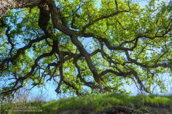
Usually, about the same time goldfields begin to bloom, valley oaks are starting to sprout new, bright green leaves. This Winter, the foliage on valley oaks at Upper Las Virgenes Canyon Open Space Preserve (Ahmanson Ranch) began to turn brown in mid-December and I saw the first new leaves begin to sprout at the end of February. This sprawling valley oak is in East Las Virgenes Canyon.
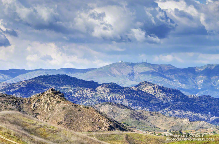
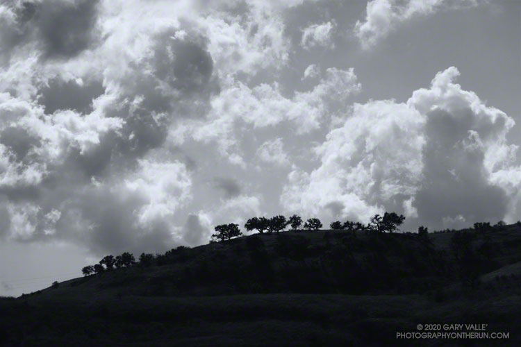
Clouds, sun and shadow accentuate the rugged topography of the northwest rim of the San Fernando Valley.
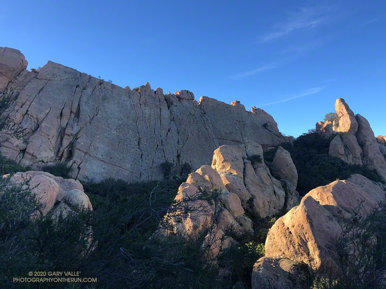
Castle Peak is the rock-capped summit on the left of the photo. Chatsworth Peak (2314′) is in shadow and behind Castle Peak. The prominent rock bands are Chatsworth Formation sandstone formed more than 65 million years ago. Oat Mountain (3747′) is the sunlit peak in the distance.
From a run on Wednesday at Ahmanson Ranch.
Some related posts: The Cave of Munits and Castle Peak, Castle Peak, Snow on Oat Mountain
Following a December with twice normal rainfall, Downtown Los Angeles (USC) experienced the fourth driest January-February on record. Now it seems the spigot has been turned back on, and March rainfall for L.A. might very well be above normal.
As of 3:00 p.m. today, March 13, Downtown Los Angeles (USC) has recorded 2.05 inches of rain this March, boosting the rain year total (since July 1) to 9.40 inches. This is about 75% of normal for the date.
More rain is forecast over the next week or so, but the major weather models differ on the projected amounts. To make up for the January-February rainfall deficit and finish the rain year close to 100% of normal, Los Angeles needs another 5.5 inches of rain by June 30.
Not impossible, given some of the forecasts, but that would be a lot of rain for this time of year. Well see!
Update July 6, 2020. Remarkably, Downtown Los Angeles (USC) ended the rain year, July 1 to June 30, within 0.07 inch of normal rainfall. It was a tumultuous rain season that saw copious rainfall in December, and then almost none in January and February — usually the wettest months of the year. Just when we started to think “drought,” the wet weather returned. Combined, Match and April precipitation was 221% of normal. That and a little rain in May brought the Los Angeles rain year total up to 14.86 inches, just short of the normal of 14.93 inches.
Update April 12, 2020. Over six consecutive days, from April 5 to April 10, Downtown Los Angeles (USC) recorded 2.96 inches of rain. This is about 325% of the normal amount for the whole month. The precipitation totals of 14.66 inches for the rain year and 14.63 inches for the water year are now above normal for the date and within about one-third of an inch of the normal annual rainfall for Downtown Los Angeles.
Update April 10, 2020. April rainfall picked up right where March left off. As of April 9, Downtown Los Angeles (USC) has recorded 2.80 inches of rain this month. This is more than three times the normal amount of rain for the entire month of April. This brings the rain year and water year totals to 14.50 and 14.47 inches, respectively. For the first time since February 1 the rainfall totals for Los Angeles are above normal for the date. Los Angeles is now within a few tenths of an inch of normal rainfall for the year, and it is still raining today.
Update March 24, 2020. On March 22, Downtown Los Angeles (USC) set a new rainfall record for the date of 1.51 inches. As of March 24, Downtown Los Angeles has recorded 4.35 inches of rain this month. This is 179% of the normal amount of rain in March. The current rain year/water year total of 11.70/11.67 inches is about 88%/90% of normal for the date. The magic number for 100% of normal rainfall is 14.93 inches — either by June 30 (Rain Year) or September 30 (Water Year).
Update March 17, 2020. As of March 16, Downtown Los Angeles (USC) has recorded 2.80 inches of rain this month. This already exceeds the normal amount of rainfall for the entire month of March, which is 2.43 inches. The current rain year/water year total of 10.15/10.12 inches is about 79%/81% of normal for the date.
The range of temperatures had been remarkable. At the Secret Trail trailhead in Calabasas, where I left my car, it had been a balmy 60 degrees. Near the start of my run from the Tapia Trailhead in Malibu Canyon, it had been a very chilly 32 °F. Near the end of the run, the temp topped out at 79 °F. That’s SoCal Winter running!
On the way to Saddle Peak, I was surprised to see how wet it was on some sections of the Backbone Trail. There has been very little rain this January, but marine layer dew, the trail’s north-facing aspect, the low sun angle, the canopy of bays and oaks, and relatively cool temps have kept the trail damp. In places it looked like it had just rained yesterday.
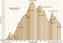
Because there’s about 1000′ less elevation gain, I usually do this run in the opposite direction, starting on the Secret Trail and ending at Tapia. This is the route described in the venerable guidebook, 50 Trail Runs in Southern California. But I’d run it in that direction a bunch of times — so here I was, chugging up the Backbone Trail, nearing the end of a 2600′, seven-mile climb from Tapia to Saddle Peak.
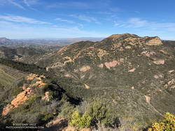
The area around Saddle Peak is yet another spectacular section of the Backbone Trail. (There are so many!) Just west of the peak, the trail winds through a narrow passage with massive sandstone rocks on either side. As the trail levels out, there is a short spur trail to the peak’s antennae-infested summit.
Even if a little obstructed, views from the top extend to Catalina, Boney Mountain, Mt. Pinos, and Mt. Baldy. Sometimes San Gorgonio Mountain and San Jacinto Peak can be seen beyond Mt. Baldy. The round trip to the summit of Saddle Peak adds about 0.8 mile. The eastern summit is slightly lower, but no antennae obstruct the view.
Getting to Saddle Peak from the Tapia trailhead is relatively straightforward, if a bit strenuous. Getting to Calabasas Peak and the Secret Trail from Saddle Peak is not as simple.
The “normal” way to get from Saddle Peak to Calabasas Peak would be to run back down the Backbone Trail to the Stunt High Trail and then follow that trail to the parking area on Stunt Road. Calabasas Peak Mtwy is across the highway and slightly downhill (west) of the parking area and leads to Calabasas Peak and the Secret Trail.
If doing the regular route, note that the Stunt High Trail crosses Stunt Road twice on the way down. In each case turn right and follow the road east about 100 yards to pick up the trail on the other side of the road. There are also various side trails to avoid.
I had been planning to do the regular route, but as I was returning to the Backbone Trail from Saddle Peak, it occurred to me there was a way to avoid backtracking. Instead of turning left on the Backbone Trail and descending to the Stunt High Trail, I turned right and continued east, past the water tank, to the Lois Ewen Overlook. From there, I ran over to the Topanga Lookout and then scrambled down Topanga Lookout Ridge to Calabasas Peak Mtwy.
This option is more adventurous, but requires good route-finding skills and being comfortable clambering down a rocky ridge. This 3D Cesium interactive view shows a GPS track of my route. The yellow track is today’s route. The red track is the usual route between the Backbone Trail and Calabasas Peak Mtwy. The view can be zoomed, tilted, rotated and panned. Placemark and track locations are approximate and subject to errors.
Scrambling down the ridge put me at “The Bench,” at the junction of Calabasas Peak Mtwy and Red Rock Road. This is a little more than a mile from Calabasas Peak. Once on Calabasas Peak, it was only about 0.6 mile to the top of the Secret Trail, and from there about 1.3 miles of mostly downhill running to the trailhead.
With about 4000′ of gain over 14 miles, it was a demanding route, with challenging route-finding and a fun scramble down a rocky ridge. Here are a few photos taken along the way.
Some related posts: Topanga Lookout Loop, Plus Saddle Peak; Secret Trail Variations; Secret Trail to Calabasas Peak
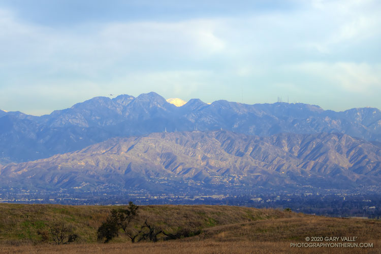
On Winter days when the sky is clear and the visibility is good, the view of the San Gabriel Mountains from Lasky Mesa can be surprisingly detailed. In those conditions you’ll sometimes see a brilliant patch of white in the distance, through a gap in the mountains.
There are a number of peaks in the San Gabriels that are high enough to be snow-covered. Which one is it?
I suppose I could have used an app to ID the peaks on the skyline, but another way would be to draw a line on a sufficiently detailed map and “connect the dots.” The line would be drawn from Lasky Mesa, through the gap, and then extended to a mountain that would have snow. An easy way to do that is to use the “Measure” tool in Google Earth.
The title photo was taken from what used to be the helipad site on Lasky Mesa. (The work currently occupying that space was the subject of a previous post.) The gap in the mountains is the saddle between San Gabriel Peak (left) and flat-topped Mt. Markham.
Drawing the line in Google Earth reveals that the snow-covered mountain is Mt. San Antonio (10,064′) — generally referred to as Mt. Baldy. The peak is about 60 miles distant. Here’s a closer view with some of the peaks identified.