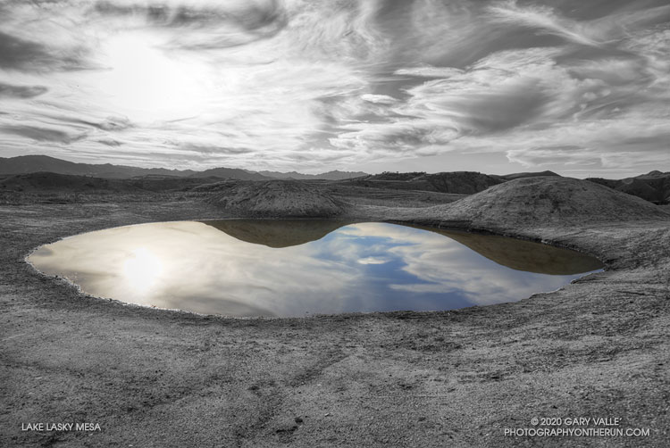
Hidden away in the central highlands of Lasky Mesa, and not found on current maps, the “lake of the four hills” is shrouded in mystery.
Perhaps the result of earth movement or some other upheaval, the hills and lake seemingly appeared overnight. They are the latest in a series of perplexing formations to suddenly materialize on the site.
Rocky Peak Road is one of my go-to wet weather running spots. The sandy soil — thanks to the Chatsworth Formation sandstone — doesn’t cake on your shoes when it’s wet. It isn’t entirely mud-free, but as long as you don’t mind a few steep hills, it’s a good choice when the weather turns wet.
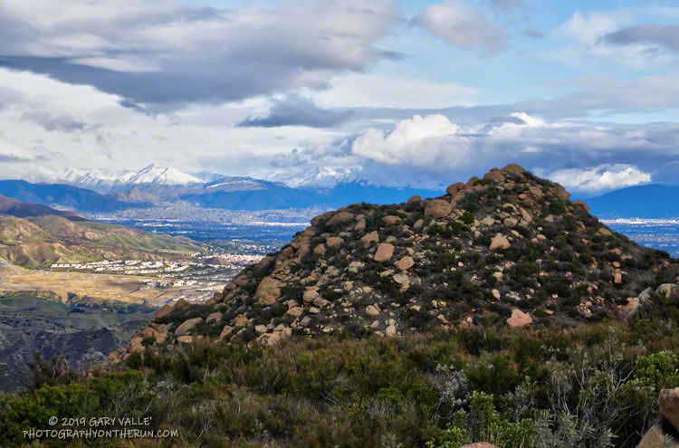
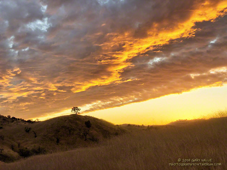
According to preliminary rainfall totals tabulated by the NWS, Rocky Peak recorded 1.22 inches of rain during the Christmas storm. The snow level had been forecast to drop to 2000′-2500′ in some areas, so as the storm was breaking up I headed over to Rocky Peak to get in a run, and see what I could see.
I’d dressed for a cool and breezy run, and was comfortable as I worked up the first steep hill. But I hadn’t run half a mile when I stopped and put on some gloves and a pair of stretch shorts. That helped, but the higher I went the colder it got. Up top, a little past Rocky Peak, my thermometer registered a chilly 38 degrees and the wind was gusting 10-15 mph. According to the NWS Wind Chill chart, that put the effective temperature at around 30 degrees.
And that’s what it felt like. Part of the problem was that I was running into the wind, which increased the chill. I had a wind shell in my pack, but once I’d reached my turnaround point and had the wind at my back, it wasn’t needed.
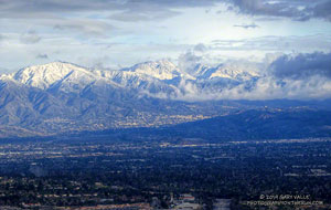
Mt. Lukens, Mt. Disappointment, San Gabriel Peak and Mt. Lowe.
There was no snow on Rocky Peak Road or Oat Mountain, but from time to time the setting sun broke through the clouds and highlighted the snow on the nearby mountains. It was a far different scene than on the usual Rocky Peak run.
December has been wet in the Los Angeles area. As of December 27, Downtown Los Angeles (USC) has recorded 4.84 inches of rain this December, which is nearly three inches above normal. Rain year and water year precipitation totals are also well above normal, and at the moment, ahead of last year. We’ll see what the new year brings!
Update January 24, 2020. Well, the new year hasn’t brought us much in the way of precipitation. January in Downtown Los Angeles has been about as dry as December was wet. So far, Downtown Los Angeles has recorded only 0.32 inch of rain this January, well below the climate normal for the date. If there is no additional rain this month, Los Angeles will end the month with about normal rainfall to date for the Rain Year (Jul 1 – Jun 30) and Water Year (Oct 1 – Sep 30). Then we’ll have to see if there is a pattern change in February, or if it is also drier than normal, as most guidance suggests.
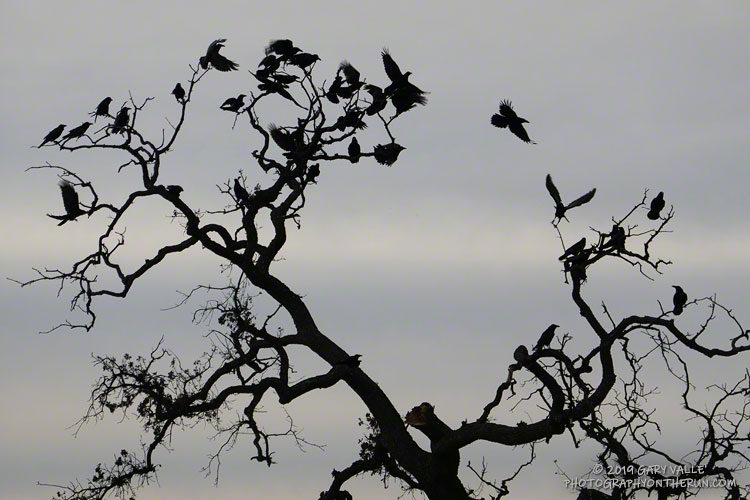
Crows have been congregating on the west end of Lasky Mesa this Fall, and the number appears to be increasing. On a run earlier this week, a friend and I watched four crows chase a small bird — probably a kestrel — off the west side of the mesa.
The Cheeseboro Canyon gathering was transient, and I hope the one on Lasky Mesa is temporary as well. Too many of the brash birds could adversely impact the limited number of kestrels and other notable birds that call Lasky Mesa home.
Follow-up on January 15, 2020. On several occasions have seen flocks of crows flying west from Lasky Mesa, toward Las Virgenes Canyon. When conditions permit, the crows use thermals to gain altitude and continue west. I’ve also noticed a general westerly flight trend of small groups of crows flying across Lasky Mesa. It may be that Lasky Mesa is a convenient waypoint on their way to a roosting/breeding location farther to the west.
Follow-up on January 3, 2020. Today, a kestrel was back in the valley oak on the west end of Lasky Mesa. No crows were nearby. Later in the run I came across a small group of crows pestering a pair of northern harriers.
Follow-up on December 19, 2019. While I’ve seen some small groups of crows in the Lasky Mesa area this week, the large congregation appears to have dispersed.
This time of year, I’m often “racing the sun” on my afternoon runs. Especially on longer runs, when the additional miles quickly consume any remaining daylight. There are benefits. Colorful sunsets are just one of them.
Tuesday’s run was one of those longer runs — from the Victory Trailhead of Upper Las Virgenes Canyon Open Space Preserve (Ahmanson Ranch) to Cheeseboro Canyon and back. One of the reasons for doing this particular run was to follow up on the reemergence of water in upper Las Virgenes Creek. As Fall has progressed, there has been a notable increase in the size and number of pools, and the amount of water in the creek. I’ve observed this in the Fall before, except during periods of drought.
This comparison shows a crossing of upper Las Virgenes Creek about one-third mile north of the junction of Las Virgenes Canyon and East Las Virgenes Canyon. It shows the intriguing reemergence of water in this reach of the creek, despite a dry Summer, and — as of Tuesday — meager Autumn rainfall. The increase in water in the reach seems to have resulted from seasonal reductions in daylight, temperature, evaporation, plant transpiration, and other factors.
Update October 22, 2019. A run over to upper Las Virgenes Creek supported the 0.46 inch of rain reported by the Cheeseboro RAWS on October 20. The ground appeared to have absorbed more rain in the Las Virgenes Canyon area, compared to the area near the Victory Trailhead. It also looked like the amount of water in the creek bed had increased.
Update October 21, 2019. The Cheeseboro RAWS, on the ridge just west of upper Las Virgenes Creek, recorded 0.46 inch of rain on October 20, the day after this run. Today, I’ll be running out that way again to see how the rain affected the creek.
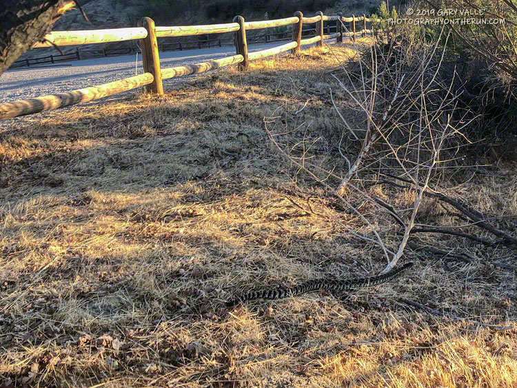
I pressed the START/STOP button on my Garmin watch and started to walk over to the horse/hiker entrance at the Victory Trailhead of Upper Las Virgenes Canyon Open Space Preserve (Ahmanson Ranch). This “end of an Ahmanson run” routine is something that I repeat around 150 times a year. It’s so routine, it’s rote. I’m not thinking about rocks or ruts, or how far I have to go. It’s a time I can relax and reflect on the run, the weather, or whatever.
Continuing toward the trailhead entry, I pulled the water bottle from my pack. Lifting my head to take a drink, and still on auto, I began to step over the first of two large wooden beams forming the entrance.
Some primitive, protective mechanism recognized the threat before I did, and I stopped mid-stride. Then it registered — a sizable Southern Pacific rattlesnake was undulating through the boxed-in area between the two beams of the entryway.
Moving quickly through the entry and into the grass, the snake barely reacted to me. With single-minded resolution, it continued on a beeline toward the brushy area near the trailhead. A single shake of its rattle was all the bother I was worth. Here’s a short video of the Southern Pacific rattlesnake at the Ahmanson Ranch trailhead.
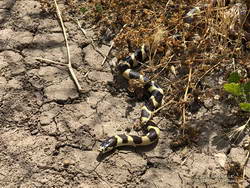
California kingsnake
Surprisingly, this was the first rattlesnake I’ve seen this year at Upper Las Virgenes Canyon Open Space Preserve . I’ve seen numerous gopher snakes, a couple of California kingsnakes, a California whipsnake, and the tracks of many rattlesnakes, but no actual rattlesnakes. Others have described various rattlesnake encounters at Ahmanson — one friend saw three on one ride!
Note: Most of these snakes were old enough to have survived the November 8, 2018, Woolsey Fire.
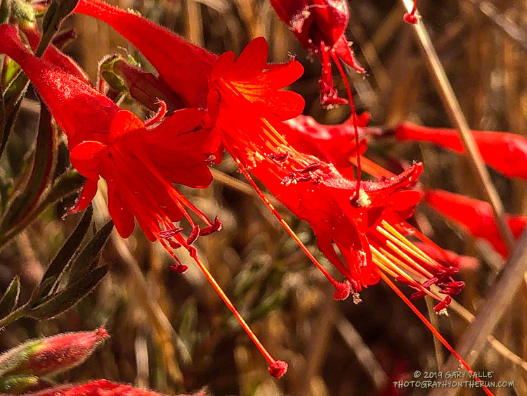
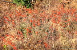
If the wildflower is red, the season is Fall, and you are in Southern California, the flower is probably California fuchsia. You might also find there is a hummingbird feeding on the “hummingbird trumpets,” or hovering nearby, watching over its flowers.
California fuchsia along Bulldog Mtwy fire road in Malibu Creek State Park.
As a result of the wet 2018-19 rain season, and somewhat cooler than normal summer, California fuchsia is especially abundant this Fall, with some exceptional displays along local trails.
I’ve added California fuchsia, and a few other flowers that are blooming this Fall, to my Weekday Wildflowers slideshow. These are wildflowers photographed this year on weekday runs from the Victory Trailhead of Upper Las Virgenes Canyon Open Space Preserve.