Category Archives: topanga state park

Visualizing Trail Runs and Other KML Data Using Cesium 3D High Resolution Terrain

Cesium ion 3D view of San Gorgonio Mountain

Google discontinued its Google Earth API/Plugin in January 2017. That technology was used on PhotographyontheRun.com for 3D visualizations of trail runs, fire data, and other data.

I’ve been looking at alternatives since then, and have recently implemented an interactive viewer using the CesiumJS and Cesium ion components of the Cesium 3D Geospatial Platform. No browser add-on or plug-in is required. The viewer uses the Cesium World Terrain high-resolution global terrain tileset, with resolutions to 0.5 meter. The West Coast of the US is one of the areas covered by this resolution.

Following are example 3D visualizations of some of my recent runs. The views are interactive and can be zoomed, tilted, rotated and panned. Click/tap the “?” in the upper right corner for help manipulating the scene. Mileages and elevation gains/losses are approximate.

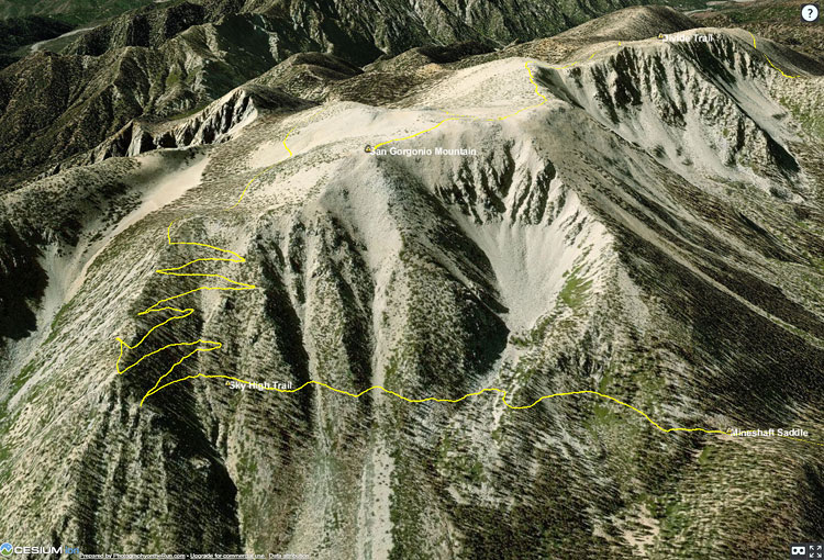
San Gorgonio Mountain Trail Run (21 mi, 4700′ gain/loss)

The initial view is of San Gorgonio Mountain from the northeast, showing the trail to the summit and the Sky High Trail. The large cirque held one of several glaciers on San Gorgonio Mountain. The GPS track is from a run in September.

San Gorgonio Mountain Trail Run and Lake Fire Burn Area

Another view of San Gorgonio Mountain with the 2015 Lake Fire burn area added. The initial view is from the northwest. The GPS track is from my run in September.

Bulldog Loop Variation (17 mi, 3250′ gain/loss)

The initial view of this popular loop is from the northeast. This variation starts/ends at the Cistern Trailhead on Mulholland Hwy. The GPS track is from a run of the loop in September.

Three Points Loop Around Mt. Waterman (20 mi, 4000′ gain/loss)

The initial view is from the Buckhorn (east) side of the loop. The loop includes a segment of the PCT in Cooper Canyon. The GPS track is from a run in October.

Top of Reseda to Parker Mesa Overlook (18.5 mi, 3100′ gain/loss)

The initial view is from the northeast, on the Valley side of the route. The Musch, Garapito and Bent Arrow Trails were done on the way back from Parker Mesa. The GPS track is from a run in October.

Hollyleaf Redberry Along the Sage Ranch Loop Trail

Hollyleaf Redberry Along the Sage Ranch Loop Trail
Hollyleaf Redberry

As is usual, it’s been hot and dry in the Los Angeles area this summer. Most of the low elevation wildflowers have come and gone, and the last measurable rain at Downtown Los Angeles (USC) was more than 90 days ago.

Holly-leaved cherry along the Backbone Trail
Holly-leaved cherry along the Backbone Trail.

Even so, there are still some colorful reminders of our wet 2018-19 rain season sprinkled along the trails of the Santa Monica Mountains and Simi Hills.

In the wake of all that rain, and the blooms that followed, several chaparral shrubs have had large crops of berries and fruit, among them hollyleaf redberry (Rhamnus ilicifolia), holly-leaved cherry (Prunus ilicifolia), and toyon (Heteromeles arbutifolia).

Are they edible? While all three plants were used as food sources by indigenous populations, knowledge of appropriate use and preparation is essential for safe consumption.

Plummer’s Mariposa Lily Along the Garapito Trail

Plummer's mariposa lilies (Calochortus plummerae) along the Garapito Trail in the Santa Monica Mountains. June 29, 2019.

When I run to Trippet Ranch from the Top of Reseda, I like to take the fire roads out and single-track trails back. The trails I use to return to the Top of Reseda from Trippet are the Musch, Garapito, and Bent Arrow Trails.

Scarlet larkspur along the Garapito Trail in the Santa Monica Mountains.
Scarlet larkspur along the Garapito Trail.

I don’t think I’ve seen as many Plummer’s mariposa lilies (Calochortus plummerae) along the Garapito Trail as I did this last Saturday. Like many other plants this showy lily seems to have benefited from the wet 2018-19 rain season and generally cool Spring temperatures.

The Plummer’s mariposa lily has a CNPS Rare Plant Rank of 4.2, which means it has a limited distribution and is moderately threatened in California. It’s not necessarily rare within its range, but its range is limited to a small area of Southern California.

Among the other wildflowers along the trail were numerous large patches of Scarlet larkspur (Delphinium cardinale) and Farewell-to-spring (Clarkia bottae).

Rainbow Along the Garapito Trail

Rainbow Along the Garapito Trail

There sure have been a lot of raindrops and rainbows lately. It seems like every run I do my shoes get muddy — and there are even creeks to cross!

Last year on this date, Downtown Los Angeles (USC) had recorded only 2.55 inches of rain since July 1. This year we’ve received 16.69 inches, and as I’m sure you’ve heard, there’s more on the way.

It may seem like a long time since Los Angeles has been this wet, but actually it’s only been a couple of years. Year before last we’d received 18.5 inches of rain by this date. We need about 1.81 inches of rain from this week’s system to catch up.

Recognize this section of the Garapito Trail? See the large embankment along the right side of the trail? In 2005, during the second wettest Rain Year in LA on record, the hillside slumped around 12′. The trail is on top of the section that dropped.

During the 2004-2005 Rain Year Downtown Los Angeles recorded 37.25 inches of rain!

Ceanothus at Sunrise

Bigpod Ceanothus in Topanga State Park

Bigpod Ceanothus is normally the first of the Ceanothus species in the Santa Monica Mountains to bloom each year. It is a foundation species in the range and can be found along most trails. These were along Fire Road 30 (Temescal Ridge Fire Road) near the beginning of a run to Trippet Ranch.

In some years it seems every shrub in the chaparral is a big pod Ceanothus and the hillsides are carpeted in white. Along a trail thick with the blossoms you may notice a subtle earthy fragrance with a spicy edge. On that same trail in the Summer, you may be startled by a loud “Pop!” when a heated pod explodes, releasing its seeds.

Spring on the Bent Arrow Trail

Encelia Along the Bent Arrow Trail

I usually do the 21 mile Will Rogers – Temescal loop once or twice a year, and that’s just long enough to forget the difficulty of the strenuous climbs, and remember the outstanding downhill on the Backbone trail, great views of the city, and lush growth in Temescal Canyon.

If the day is warm the return from the coast can be particularly brutal. Today it was cloudy and cool for much of the run, and it wasn’t until the final mile on the Bent Arrow Trail that the sun broke through.