
Category Archives: trails|bay area
Golden Gate Bridge Run
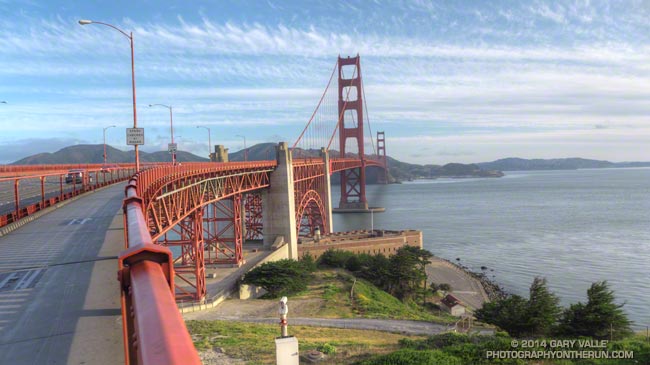
If you’ve driven across the Golden Gate Bridge during the afternoon and seen the throngs crowding the sidewalks you might think of running across the Bridge as being akin to game of pedestrian pinball. But there are times when you can have the Bridge nearly to yourself and enjoy a meditative run across this icon of icons.
According to the Golden Gate Bridge web site the east (pedestrian) Sidewalk opens at 5:00 am year around. Starting a couple of miles away I reached the south side of the Bridge at 7:00 am on a Sunday, and even at that late hour there were very few people on the Bridge.
The distance across the bridge from gate to gate is about 1.7 miles. The Coastal Trail can be accessed from the north side of the Bridge, so depending on where you start in San Francisco you could run across the Bridge and then do a nice trail run on the Coastal Trail and only add 3.7 miles (or so) to your total distance.
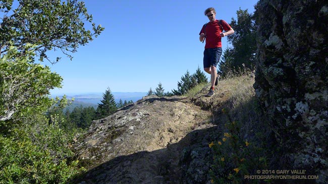
Running Down Diablo
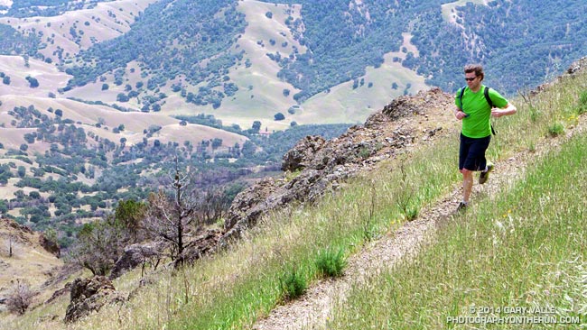
More often than not when you run down a mountain, you’ve also had to climb up it. Not so today. Today our Mt. Diablo run started on the summit of Mt. Diablo (3849′), worked over to North Peak (3557′), and then descended the Bald Ridge, Eagle Peak and Mitchell Rock Trails to the trailhead at the Mitchell Canyon Interpretive Center and Ranger Station.
I was more than happy to save the ascent of Mt. Diablo for another day. With the AC100 just a couple months away my mileage has been on the increase. Yesterday, after driving up to San Francisco, Brett had taken me on a run on Mt. Tamalpais. Earlier today I’d done a run to Fort Point and this afternoon would be doing another run when we returned to the city.
Except for an astoundingly steep and slippery section of service road between Prospector’s Gap and North Peak, today’s run was nearly all single track trail. Not the “cruise downhill, don’t have to think about it” kind of single track, but technically interesting single track that tries hard to find a way to trip you up and knock you down.
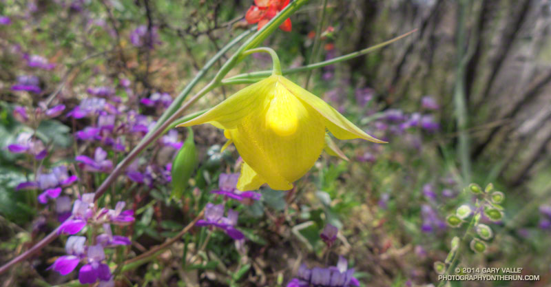
One of the reasons for doing Diablo was to see if we could find the rare and endangered Mount Diablo fairy lantern (Calochortus pulchellus). There were a surprising number (50-100) of the yellow flowers along the North Peak and Bald Ridge Trails. It might be assumed that this was due to the area being burned in the September 2013 Morgan Fire, however there appeared to be as many instances of the plant outside the burn area as inside. I think there is another explanation.
The unusual pattern of rainfall that we experienced this rain season in Southern California was replicated across much of the state, including the Bay Area. As of February 1 San Francisco Airport (KSFO) had recorded only 1.5 inches of rain since July 1 and storms in February and early March accounted for a large part of this season’s rainfall.
This pattern of rainfall, sun and temperature appears to have favored wild lilies, particularly mariposa lilies of the genus Calochortus, such as the Mt. Diablo fairy lantern. The butterfly mariposa (Calochortus venustus) was very widespread on Mt. Diablo, numbering in the thousands. It appears to fill a similar ecological niche as the Catalina mariposa (Calochortus catalinae) in the Santa Monica Mountains. The Catalina mariposa was also very abundant this year, along with some other members of the Lily family.
Here are a few photos from the Diablo run.
Coastal Trail Runs and Pacific Coast Trail Runs offer trail running events that start and finish at the Mitchell Canyon Trailhead on Mt. Diablo. Brazen Racing also organizes the Diablo Trails Challenge.
For more information about Mt. Diablo see the Mt. Diablo State Park, Save Mount Diablo and Mount Diablo Interpretive Association web sites. This State Park brochure includes a trail map.
Related post: Diablo Trails Challenge 50K 2018
Tamalpais Trail Run
Running ahead of me at a brisk pace, Brett suddenly stopped and turned, gesturing for me to slow and be quiet. On the shaded trail ahead I could see something large and brown hunched over on the trail. It took a moment to realize that it was a big male turkey in full regalia.
We were on Mt. Tamalpais, and about a half-mile into an afternoon run from the Bootjack parking area in Mt. Tamalpais State Park. This scenic loop was the first of several runs over a too-short Bay area weekend visit. One of the innumerable loops and variations in and near the Park, our route included segments of the Old Mine, Rock Spring and Matt Davis Trails.
According to this November 2012 article in the Marin Independent Journal the turkeys were introduced into Marin County in 1988 by Fish & Game to provide hunting opportunities on private land. They have since become a nuisance and usurp resources from native species. During the birds’ mating season they have reportedly frightened hikers and bikers. (I might have scoffed at that statement before seeing the size of this tom.)
It was a warm in the sun, cool in the shade afternoon with the temperature in the mid-70s. Earlier in the week an offshore flow had pushed temperatures in the Bay area well into the 90s. The heatwave produced numerous record highs, with the temperature at San Francisco Airport reaching over 90 degrees on Tuesday and Wednesday. The remote automated weather station (RAWS) on Middle Peak can be used to get an idea of the weather on Mt. Tam.
Today the winds were onshore, but the visibility was still very good. The twin summits of Mt. Diablo could be clearly seen across the bay, about 40 miles away. Mt. Diablo would be the site of one of tomorrow’s runs. Rumor had it the rare Mt. Diablo fairy lantern was blooming, and Brett had planned a run on Diablo that included North Peak, Bald Ridge and Eagle Peak.
Here are a few photos from today’s run on Mt. Tam. More info can be found on the Mt. Tamalpais State Park and the Friends of Mt. Tam web sites. This State Park brochure includes a trail map.
Coast Redwoods Along the French Trail in Redwood Regional Park
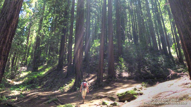
Coast redwoods are spectacular trees, often growing to more than 200 feet tall. They can attain phenomenal size. According to Famous Redwoods, the tallest is the Hyperion tree in Redwood National Park, with a height over 380 feet. The 2021 National Register of Big Trees lists the Lost Monarch in Jedediah Smith Redwoods State Park as the Champion coast redwood. It has a circumference of 950 inches (79.2 feet). There are reports of even larger coast redwoods.
Here’s a Calflora/Google Maps image and live link of the distribution of coast redwoods in California. The southernmost naturally-occurring coast redwoods are in Monterey County, in the Southern Redwood Botanical Area of Los Padres National Forest.
The title photo is of coast redwoods along the French Trail in Oakland’s Redwood Regional Park and is from a hike in mid-May.
Related post: Malibu Creek State Park Coast Redwoods
San Francisco Sights Trail Run
The Presidio of San Francisco is a favorite of local and visiting runners. One of innumerable route variations, this 7.5 mile run is jam-packed with iconic sights and memorable points of interest.
Brett and I started the run near the Chestnut gate of the Presidio. The first stop was the Letterman Digital Arts Center, the headquarters of Industrial Light and Magic and LucasArts. You can grab a cup of coffee at the Starbucks here, and then stop by the Yoda Fountain. Statues of motion picture pioneer Eadweard Muybridge and TV pioneer Philo T. Farnsworth are also on the grounds.
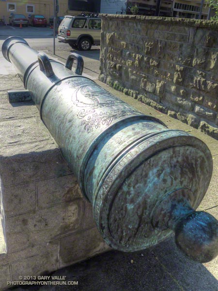
Circling around to the Letterman complex entrance we returned to the Presidio gate at Lyon & Lombard, which is flanked by two 18th century bronze Spanish cannon. The 6-inch caliber (24-pounder) cannon are marked with the ornate cipher of King Carlos III. The information imprinted on the breech ring indicates they were cast two days apart in Seville in December 1783. Even older Spanish cannon can be found at the Officers Club and elsewhere in the Presidio.
Turning right (south) we ran a few blocks up Lyon Street to the popular Lyon Street steps. There are two groups of steps, the first set being steeper than the second. One of San Francisco’s most exclusive neighborhoods, Pacific Heights, borders the steps.
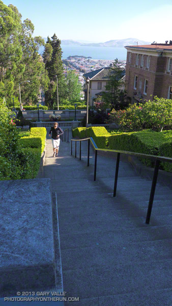
If you check online you’ll see counts of the Lyon Street steps ranging from around 241 to 291. Brett & Amanda counted the steps by section on another occasion and counted 63, 62, 46, 60, and 60 steps — for a total of 291 steps. The curb in the middle near the basketball hoop was not counted.
From the top of the Lyon Street stairs we re-entered the Presidio at Broadway, crossed Presidio Blvd, and then continued west along West Pacific Avenue. Wood Line, the first of two Andy Goldsworthy pieces passed on the run, is below West Pacific Avenue and between Lovers Lane and Presidio Blvd.
In about a half-mile we picked up the Bay Area Ridge Trail near the Arguello Gate and the Presidio Golf Course Clubhouse. Although not included on our route today, Inspiration Point is nearby and can be visited using the upper Ecology Trail.
Following the Bay Area Ridge Trail we crossed Arguello Blvd and continued uphill a short distance to Andy Goldsworthy’s Spire. Today Spire pointed into a clear blue sky, but on other days it can be nearly lost in fog. Over time, the young cypress and pine trees surrounding Spire will grow to dominate the skyline and Spire will shrink until it becomes a lost thought from another time.
About a half-mile beyond Spire the northwest-trending Bay Area Ridge Trail turned west, near the connector trail to the National Cemetery Overlook. Following the trail we continued west, past Rob Hill Campground to Washington Blvd. and then joined the Coastal Trail at the Pacific Overlook.
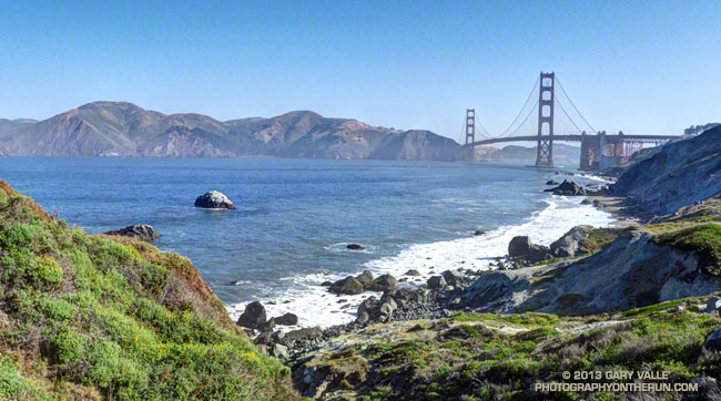
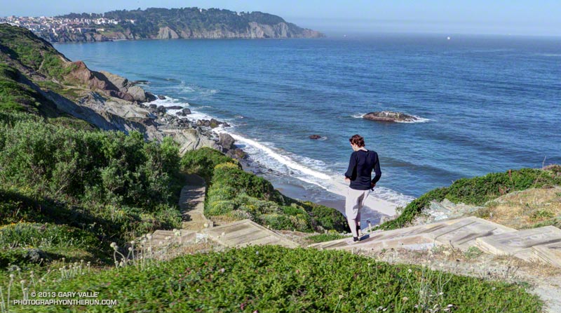
Here the iconic views of the Pacific shoreline and the Golden Gate begin. Taking advantage of the superlative weather, we ran down the Batteries to Bluffs Trail toward Marshall’s Beach and south to Battery Crosby, looping back up to the Coastal Trail and the Pacific Overlook.
The fantastic views continued as we ran north on the Coastal Trail, past Battery Geoffrey and other fortifications that protected the Golden Gate. Running under the Golden Gate Bridge we left the Coastal Trail (which crosses the bridge) and ran down the Battery East stairs to the Golden Gate Promenade.
Not that much bigger than a large container ship, Alcatraz looked like a huge tramp freighter out in the bay, steaming through the morning haze. Already late for breakfast, we tried to keep the pace up as we ran along the Promenade. At Crissy Field I paused for a moment to photograph Huru, one of Mark di Suvero’s huge steel sculptures.
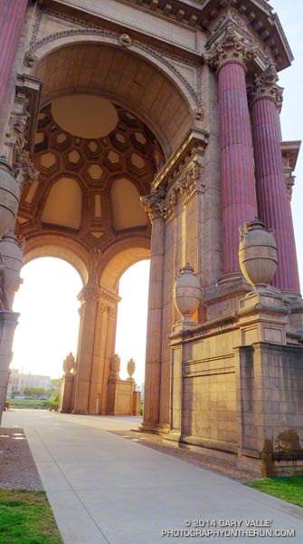
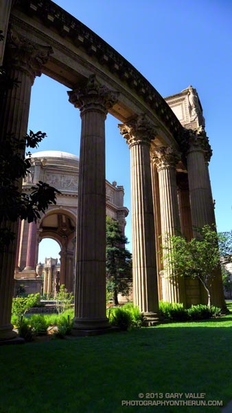
Leaving the shoreline at the marina, we crossed Marina Blvd. One more stop was on our itinerary — the Palace of Fine Arts. Built for the Panama Pacific International Exposition in 1915, and rebuilt in 1965-66, architect Bernard Maybeck’s vision was that of “a Roman ruin, mutilated and overgrown.”
Out of time, I took a few photos and we checked on the nest of the swans Blanche and Blue Boy, residents of the Palace’s lagoon. One swan was on the water, but the nest was empty. Later we learned that four cygnets had hatched just days before.
Here’s a slideshow of some photos from the run. This interactive Cesium browser View shows the GPS track of our route. Here also is a Park Service & Presidio Trust map of the Presidio (PDF).
Some related posts: Spire, Wood Line, Cooler Running, Inspiration Point – Golden Gate Bridge Loop