Category Archives: trails|los padres

Western Tiger Swallowtail Laying Eggs on Snow Bush

Western Tiger Swallowtail Laying Eggs on Snow Bush

We had run from Mt. Pinos (8831′) to Mt. Abel (~8280′) on the Vincent Tumamait Trail stopping by Sawmill Mountain (8816′) and Sheep Camp (8200′) along the way. Valley temps were forecast be well into the 100s, but here had ranged from a cool 60-something in the shade to the high 70s on the exposed sections of trail — perfect for trail running.

I’d paused at about 8700′ on the way back up Mt. Pinos to take a photo of some phlox, when a western tiger swallowtail flitted past and started to land here and there on a spiney low shrub at the margin of the trail. There was something peculiar about the butterfly’s behavior. Rather than stopping completely, it would hover briefly at one spot and then move to another. There were no flowers on the snow bush where it was hovering, so it wasn’t feeding.

Perhaps 18-24 inches away, the butterfly reacted when I started to move the camera, so I just stood quietly, holding the camera near my waist and took several photos.

A closer look at the photos revealed the butterfly was laying golden-green eggs on the snow bush.

Some related posts: Tiger Swallowtail on Snow Plant, Western Tiger Swallowtail, Vincent Tumamait Trail, Thunderstorm, Atmospheric Dynamics

Cold Spring – Romero Loop

Forbush Canyon Trail in the Santa Barbara Back Country

This is an adventurous loop that starts and ends at the Cold Spring trailhead, low on the slopes of the Santa Ynez Mountains in the Santa Barbara Front Country. The route climbs the Cold Spring Trail to Camino Cielo on the crest of the range, and then descends to Forbush Flat and Blue Canyon in the Santa Barbara Back Country.

The Front Country views on the Cold Spring Trail are spectacular, and the Back Country segment from Forbush to Blue Canyon has a classic, isolated character, accentuated by grassy flats, sprawling oaks, gurgling springs and unique geology. Montecito Peak (3214′) can be climbed on the way up the Cold Spring Trail and depending on how much time you spend on the summit, adds about 15 minutes.


I was running with Kevin Young, whom I’d met during the Backbone Ultra. Kevin is long-time resident of Santa Barbara and this is just one of the challenging routes in his backyard. As is the case with many trail runs, the mileage of this loop — about 22 miles — isn’t the best indicator of its difficulty. Many variations of the loop are possible, but one thing they all have in common is lots of elevation gain.

Thanks to the marine layer it was cool along the immediate coast, but inland temps were hot. When we started the run the temperature at the Montecito RAWS was 60°F. A few hours later when we were climbing out of Blue Canyon on the memorably steep Romero Trail the in-the-sun temperature at nearby Los Prietos was around 100°F.


Having done this loop a number of times, Kevin knew it was longer than it looked, and had stashed some goodies at the Romero trailhead. You might think 100 oz. of water would be plenty for 16 miles. On a different day it might be, but today we both ran out of water part way down the Romero Trail. Neither one of us had particularly fresh legs. Kevin was training for a 100 miler later in May and had run 20 miles the day before.

The PB & J sandwich at Romero hit the spot, but after drinking a 16 oz. recovery drink, half of a large bottle of water, and some Gatorade, I wondered if I had overdone the fluids. Nope — it actually helped a lot and my running attitude improved considerably.

Kevin’s route back to the Cold Spring trailhead from Romero initially followed the Nine Trails course on the Edison Catway, but after reaching the Buena Vista Trail continued down to Park Lane. Here we picked up the Old Pueblo Trail, and then worked across to the McMenemy Trail. We followed the McMenemy Trail to the Hot Springs Trail, which we took down to Mountain Drive. From the Hot Springs trailhead it was about a mile on Mountain Drive back to the Cold Spring trailhead. Even though it had a lot of up and down, this part of the run turned out to be surprisingly cool and enjoyable.

For maps of the area see the Santa Barbara Hikes web sites.

Here’s a slideshow with a few photos from the run. We did this run last Sunday, April 28.

Google Earth KMZ Files of Southern California Trail Runs

Introduced around 2000, the Garmin eTrex was the first GPS unit I used to trace a trail run. The GPS tracks were imported into TOPO! where the length of a run could be measured, an elevation profile generated, and the topography of the run examined.

Since the eTrex was designed to be used in an “orienteering” position — flat in your hand in front of your body — it would frequently have trouble receiving GPS satellite signals if hand-carried while running or hiking. About the time enterprising hikers and runners began to resolve this issue with creative hats, holsters and harnesses, Garmin released the Forerunner 201, greatly simplifying the task of tracing a route.

In 2005, while preparing a presentation about kayaking Piru Creek for a meeting with the Forest Service, I stumbled onto Keyhole.com. To say I was blown away by this bit of “Eureka” technology would be an a gross understatement. Now, in addition to seeing Piru Creek in photographs, and on a topo map, you could get a “before you paddle” preview using Keyhole — even if you couldn’t paddle class IV whitewater! Google acquired Keyhole in late 2004 and launched Google Earth on June 28, 2005.

Shortly after Google Earth was launched, SportTracks added the ability to launch Google Earth and view the GPS trace of a run or other activity. Since SportTracks could also directly import data from Garmin’s Forerunner, the software made it very easy to view a run in Google Earth.

I’ve been working on updating the posts on Photography on the Run that reference a trail run to include a link to a Google Earth KMZ file. A KMZ file is just a zipped KML file, and either can be opened in Google Earth. A list of the trail runs with KMZ file links can be found by clicking “Google Earth KMZ Files of Trail Runs” in the sidebar.

These are actual tracks recorded by a GPS during a trail run and may contain GPS errors, route-finding errors, and wanderings that are difficult to explain. In a few instances tracks have been modified to correct errors, or to remove side excursions that are not part of the usual route, but not all errors have been corrected. No claim is being made regarding the appropriateness or suitability of the routes indicated.

Topatopa Bluff

Fire Break on West Ridge of Topatopa Bluff

Fire Break on West Ridge of Topatopa Bluff

Crossing Sisar Creek, I debated running through the cool water. I had been running non-stop since White Ledge Camp, and had been pushing the downhill. It was a warm day and my feet were hot and my socks damp and gritty — it would feel great to dunk them. But gravity and the nearness of the trailhead pulled me across the gurgling creek and I continued to run.

Looking down Sisar Road I could see a couple of riders on horseback, accompanied by a hiker. As I approached them, I slowed and then walked. They asked me how far I had gone, and I replied, “Topatopa.” The hiker responded that she hadn’t been to the summit since the Day Fire threatened the area, and asked if it was open. I told her that I thought so. I had checked the updated closure map on the Los Padres National Forest web site, and the best I could tell, Topatopa Bluff (peak 6367) was just outside of the closed area.

Earlier, I had run up this road to trail 21W08, the Red Reef Trail, and then followed the recently groomed trail up past White Ledge, to Hines Peak Road.

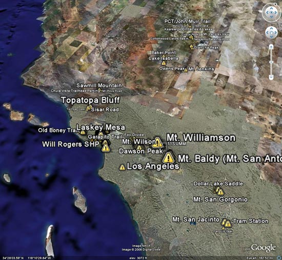
On the way up the road, the view of the bluff had been deceptive. The highpoint wasn’t atop the the most obvious of the layered cliffs of 50 million year old Matilija sandstone, but was an indistinct summit on the left side of the formation. This Google Earth image gives a good overview of the location of the peak.

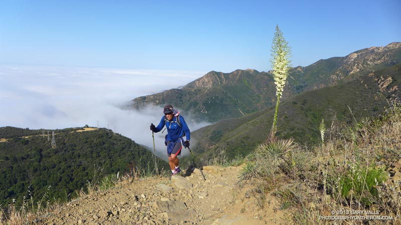
Above White Ledge Camp there had been great views of the Ojai Valley, the coast from Pt. Mugu to Ventura, and the Channel Islands. At the point where the Red Reef Trail met Hines Peak Road a large area had been cleared of brush, but had not burned. After running a few tenths of mile east on the road, I had seen hints of a trail switchbacking up through the thick brush on the west ridge of Topatopa Bluff, and left the road.

A fire break had been constructed along the crest of this unburned ridge, more or less on top of the right margin of the trail. Judging from the berms along the break, in addition to hand crews, a dozer had been used to the cut the swath. Given the steepness of the terrain, this must have been class V dozer-driving! Using the remaining segments of the trail as much as possible, I had worked my way up the final 1000′ of elevation and plodded onto the unburned summit.

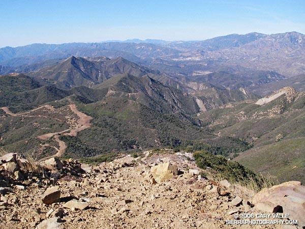
It was sobering to stand at the edge of the fire area and see the full extent of the 162,702 acre fire. The day was clear, and Mt. Baden-Powell could be seen in the San Gabriel Mountains, some 75 miles to the east. To the east-northeast, past Hines Peak and in the direction of I-5 and Pyramid Lake, the earth had been burned and blackened, and nearly all vegetation appeared to have been consumed.

According to news reports, the month-long fire started on Labor Day near Pyramid Lake, more than 20 miles distant, and was not contained until October 2. Approximately 4600 firefighters from 39 states fought the fire.

Substantial portions of the Sespe and Piru Creek drainages were burned in the fire. Even without considering the effects of the fire, which generally increases runoff, these tributaries of the Santa Clara River have the potential to produce high flows. On January 10, 2005, the USGS gage 11113000 SESPE C NR FILLMORE recorded a peak flow of 85,300 cfs, and the USGS gage U11109600 PIRU CREEK ABOVE LAKE PIRU CA a peak of 40,000 cfs. Smaller creeks that extend into the burn area could also produce higher than normal flows.

In part due to a developing El Niño, an increased probability of higher than average precipitation is projected for Southern California. While an above average amount of precipitation is by no means guaranteed, the wet outlook is no doubt one of many issues being considered by the Day Fire Burned Area Emergency Response team.

Here’s a Google Earth image and a Google Earth KMZ file of a GPS trace of my route.