A good way to think of this adventure is as an excellent 17 mile trail run on the PCT north from Walker Pass (5217′), combined with a three mile scramble up and down the rocky southwest ridge of Owens Peak (8453′).
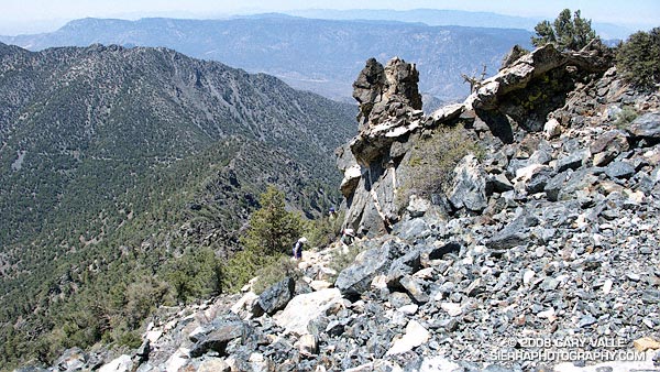
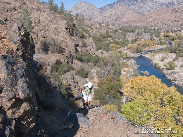
Based on the expanse of granite seen from Hwy 395, I had visualized the southwest ridge of Owens Peak as a somewhat vegetated but relatively clean ridge. Wrong! The ridge is a geologically complex mix of fractured metamorphic, metavolcanic and gabbro rock capping the granite of Owens Peak. In most areas the rocky sections of the ridge are bounded by dense brush and pinyon pine.
We pretty much stuck to the crest of ridge on the way up, continuing up and over the steep outcrop just below the summit. Although it was an interesting section to climb, the outcrop was quite loose, and we dropped below it on the descent.
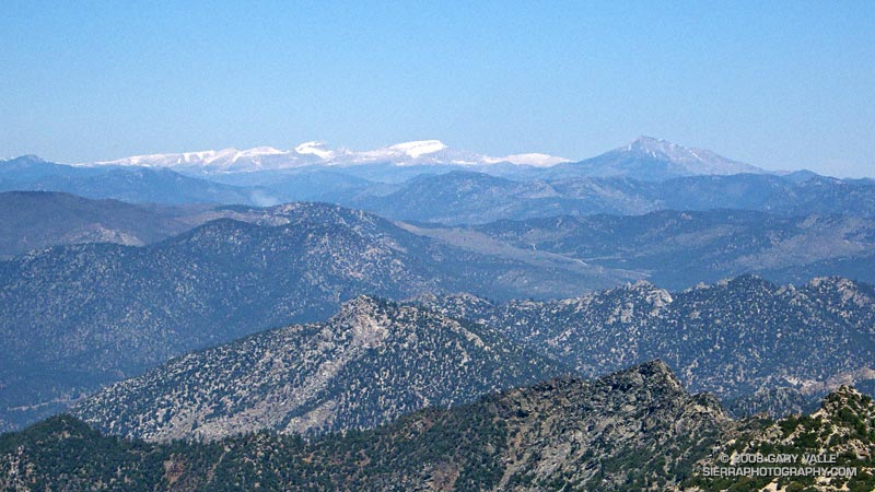
Owens Peak is relatively isolated, and the views from the summit are sweeping. To the north we could see Mt. Whitney, Mt. Langley, Olancha Peak, and the windblown crest of the Sierra between Army and New Army Pass.
Not everyone would see the positive aspects of doing a 10 mile route to a peak that could be done in only 3.5 miles — or enjoy the ups and downs, and somewhat tedious route-finding along a brushy and crumbling ridge. It’s an acquired taste. It was good to share the experience with enthusiastic friends who were still smiling as we jogged down the last yards of trail to the car.
Here’s a Google Earth image and a Google Earth KMZ file of a GPS trace of our route. GPS reception was weak at times on the way up and the track has been edited to remove some of the larger errors.
Note: After the Spring snowmelt, it appears there are no natural water sources on the PCT between Walker Pass and Owens Saddle (mile 8.6), or on the ridge.
I was headed home from a whitewater slalom training camp on the Kern River, and wanted to take advantage of being in the Southern Sierra and run an unfamiliar section of the Pacific Crest Trail.
Yes, it was windy and there were lenticular clouds in the lee of the Sierra, which meant it might get REALLY windy. No, I didn’t have my regular trail shoes or a hydration pack. Yep, there was some snow on the north side of the peaks on either side of the highway.
The plan was to do an out and back run north on the PCT from Hwy. 178 at Walker Pass (5250′). I didn’t know how far. I hoped far enough to check out the approach to Owens Peak. But that would depend on the amount of snow on the trail, how cold and windy it became, and how much elevation gain my legs had left in them.
It might not seem that paddling a kayak would be hard on the legs, but your legs are your primary connection to the boat, and my legs were worked following several days of strenuous paddling.
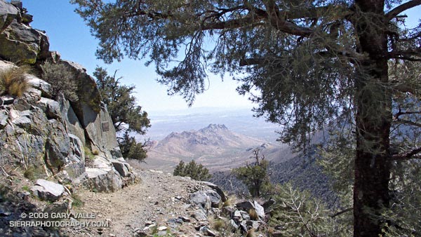
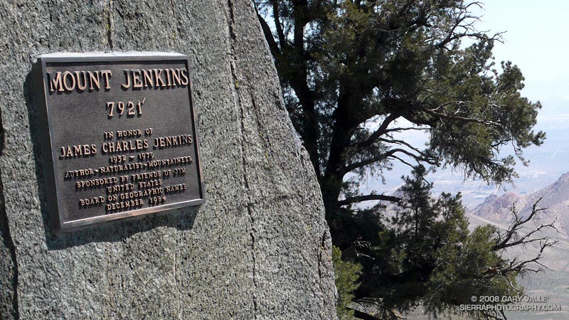
This post’s photograph was taken about five miles into the run. The plaque commemorates the naming of Mt. Jenkins. It honors J.C. Jenkins, whose Exploring the Southern Sierra and Self Propelled in the Southern Sierra books have inspired many an adventure. It was placed where the south ridge of Mt. Jenkins intersects the PCT.
I continued a mile and a half to a point where I could see the saddle and ridge leading to the summit of Owens Peak. Rounding a corner, I emerged from a wind protected traverse, and was slammed with a cold gust of wind. Ahead, I could see another long stretch of snow covered trail. Owens Peak would have to wait…
Due to fire concerns, Los Padres, Angeles, Cleveland and San Bernardino National Forests remained closed this weekend, so I headed back up to Kernville to meet some friends and run the Whiskey Flat Trail — a sizzling trail in the summertime that has been on my running to-do list for years.
Tucked away in a corner of the Southern Sierra on the banks of the Kern River, and only about a 3 hour drive from Los Angeles, Kernville usually brings to mind images of rafts, kayaks and exciting whitewater, but more than great paddling adventures can be had here.
Sequoia National Forest and the Golden Trout Wilderness afford an extensive array of hiking, mountain biking, climbing, fishing, trail running, and other recreational opportunities. Lower elevation adventures are generally within about a 30 minute drive of Kernville, and higher elevation adventures about an hour’s drive.
We did the approximately 15 mile Whiskey Flat Trail north to south, starting at McNally’s Restaurant and Resort, about 15-20 minutes north of Kernville on highway Mountain 99. The trail is accessed using the Fairview footbridge and is on the opposite side of the river from the highway. It is a gnarly up and down trail, best done in cool weather, with pleasant views of the river and the surrounding mountains.
On it’s way downstream to Burlando Road in Kernville, the trail crosses several creeks and canyons, gaining about 1000 ft. and losing about 1500 ft. Sometimes the trail is yards from the river and at other times so distant as to be taunting. As is the case when paddling this part of the river, the triangular form of peak 6047, near Corral Creek, is a distinctive landmark, that soberly marks progress down the river.
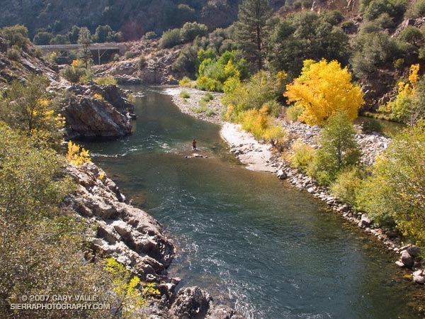
It is a trail that is long for its length and modest elevation gain. There are sandy stretches, rocky sections, stretches with V-ruts, steep uphill sections, and long stretches of perfectly graded downhill. About 8.5 miles into the run a striking section of trail traverses a cliff above Sock’em Dog, a class V rapid on a reach of the river named the Thunder Run.
All in all it was a enjoyable run that would be brutal in hot weather and a high sun. Even with the temperature topping out at only about 80 degrees, I was glad I took extra water!
Here’s a Google Earth image and Google Earth KMZ file of a GPS trace of our route. Near the end of the run, after crossing Bull Run Creek, various use trails have evolved. The main trail forks right and does not cross private property. The various routes can be checked out on Google Earth.
Update 08/17/10. About half of the Whiskey Flat Trail appears to have been within the area burned by the Bull Fire. Here’s a Google Earth interactive browser view of a GPS trace of the Whiskey Flat Trail (from last year’s Burger Run), and the area burned by the Bull Fire based on the most recent GEOMAC fire perimeter (dated 08/01/10). Also included is a GPS trace of the Cannell Plunge route from MountainbikeBill.com.
One of many excellent hikes/runs in the Southern Sierra, the River Trail starts at Johnsondale Bridge — about 19 miles north of Kernville, California on highway Mountain 99 — and follows the river north 4 miles to Four Mile rapid. Here the trail turns east and works up to the Rincon Trail.
This section of the Kern River is part of the beautiful and challenging Forks of the Kern class V whitewater run. Numerous class IV rapids and the class V rapids Carson Falls and Confusion are found on this reach. In the Spring and Summer expert kayakers and rafters may be seen maneuvering among the many boulders and drops. (A Forest Service permit is required to paddle the Forks.)
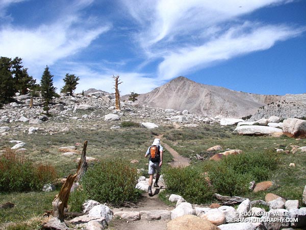
The sky was brightening in the east, and sunrise was approaching when I met Miklos and Krisztina at the Denny’s in Sylmar. We were already wasting light. The plan was to drive from near sea level up to Horseshoe Meadows, at about 10,000′ on the Sierra east side. The hike/run we had in mind was a keyhole loop from the Cottonwood Lakes Trailhead up (old) Army Pass and then down New Army Pass. If we felt OK at the top of Army Pass, we would also do Mt. Langley (14,026′).
The weather forecast looked good. There was a chance of some gusty southwest winds in the afternoon, but temps were warm and there was virtually no chance of T-storms. With a record low Southern Sierra snowpack, there was almost no chance that an ice axe would be required on Army Pass. I was familiar with the route on Langley and down from New Army Pass, and expected to be back to the car well before sunset. But, just in case, the moon was about half full.
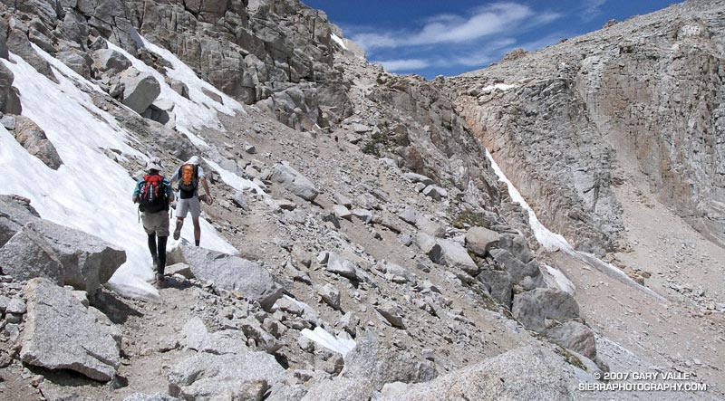
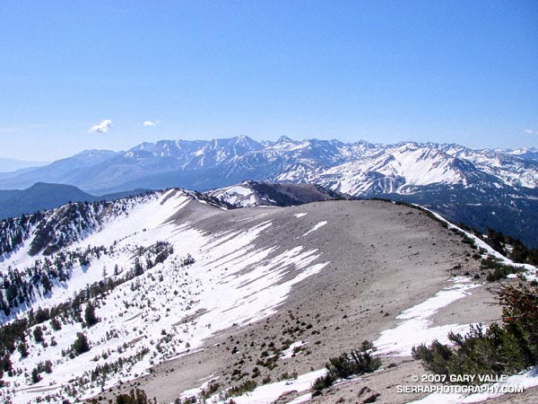
Low snow year on Army Pass. June 23, 2007.
In fact, there had been very little snow on Army Pass, or anywhere else. We reached the pass relatively quickly, and decided to continue to Langley. Now, after another hour of hiking, we were above a prominent rock band that extends across Langley’s south face, and making good progress.
I’ve been convinced for some time that pursed-lip breathing helps me at higher altitudes, particularly when I’m not well acclimated. There’s a skill to it. There seems to me an optimum blend of heart rate, respiratory rate, and the amount of resistance created on exhalation. When all these factors are in balance, the breathing technique is almost automatic and effortless, and it really does seem to help. It certainly seemed to be helping me now.
I topped out a few hundred yards west of the summit, and ambled over to the high point of the peak. On a scale of 1 to 10, I felt pretty good — maybe a 7. Making an effort to stay hydrated, consume plenty of calories, and not push the pace too hard seemed to have worked — at least this time.
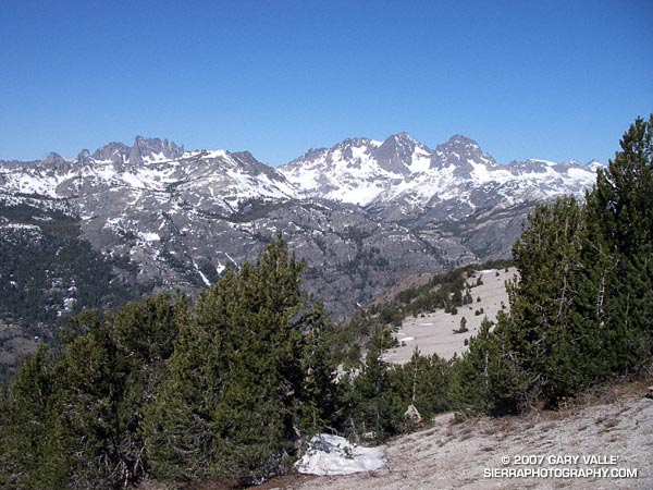
The view along the crest to Mt. Whitney and the peaks of the Kings-Kern Divide was telling. It was remarkable just how little snow there was at the highest elevations of the Sierra. A week before I had been paddling the Kern River. Now I could see why the flow on the upper Kern was dropping so fast.
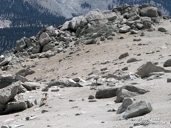
Big horn sheep on the slopes of Mt. Langley. June 23, 2007.
Miklos and Krisztina joined me on the summit, and after taking a few summit photos, we headed down. Screeing down the slopes below the rock band, we were startled when a herd of perhaps 20 big horn sheep rumbled across the slopes below us. They flowed across the rough landscape like quicksilver. Graceful and robust, they moved effortlessly between the rocks and up a small slope. In the moments it took me to react, grab my camera, and turn it on, all but two large rams trailing the group, had disappeared.
Energized by the sight of these fleet-footed animals, we continued down to the saddle at Army Pass, and then up and over New Army Pass. Before sunset we would be back to the car, and before dark, eating dinner at Lone Pine. Before midnight we would be back in L.A. Here’s a Google Earth image and Google Earth KMZ file of a GPS trace of our route.
Note: Going to higher altitudes without properly acclimating can result in very serious, life-threatening illnesses. There is much information available on the Internet regarding altitude sickness and acclimatization. As a starting point see UIAA Medical Commission – Advice and Recommendations and Wikipedia: Altitude sickness.
Located near Mammoth Mountain, San Joaquin Ridge extends from Minaret Summit (9265′) north about six miles to San Joaquin Mountain (11,601′). Views from this ridge are legend, with broad vistas that include Mt. Morrison, Red Slate, Mammoth Mountain, the Minarets and Ritter & Banner, Mono Lake, and much more. In good weather it is an awe inspiring locale in which to hike, ski or run.
This day, the conditions for running the ridge are ideal. In the wake of a weak weather system, skies are mostly clear, and a cool breeze reduces the heat of the harsh sun, producing a welcome warmth. Winter snow is already receding from the ridge crest, allowing a choice of routes over, or around, remnant drifts and cornices.
Returning from a high point a few miles distant, bounding strides lengthen, and I seem to soar down the ridge, weaving among the stunted pines, glissading across bands of snow, caressing the wind and flying up or down slopes with equal ease. It has become a run that defines the root experience of trail running and the rewards of being in the mountains. There is freedom of motion — and emotion — in every stride.
Ahead of me, a pair of ravens turn and the Sun glistens from back to wing. Individual feathers ruffle as wings are adjusted to increase lift, and turns are tightened. Soon we are soaring high above the Sierra, and all things seem possible.