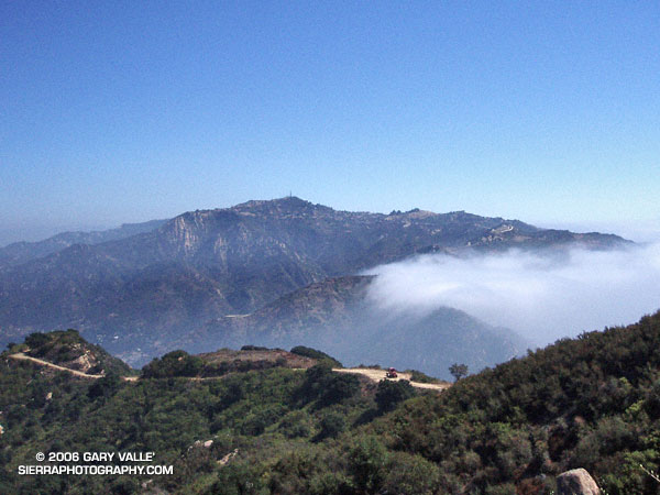
Was up early, hoping to beat the heat and do a local run. It looked as though thick high clouds would keep temps down for a while, so several good runs were a possibility. After some debate, I decided on an out and back run to Saddle Peak.
My usual route starts at Piuma Rd. & Malibu Canyon, and follows the Backbone Trail approximately 6.5 miles to a short spur trail which leads to the actual summits of Saddle Peak. Much of the route used to part of the Bulldog 50K, and can be combined with the Bulldog Loop to do a self-supported 27.5 mile run. Here’s a Google Earth image of a GPS trace of both routes.
While both the Bulldog and Saddle Peak routes have great views, are about the same length, and have similar elevation gains, there is one significant difference. Except for a short, 0.3 mile stretch along Piuma Rd., all of the Saddle Peak route is on single track trail.
The trail covers a variety of terrain and habitats. Some sections are lush and shaded, with bay trees, moss-covered rocks and several species of ferns. Other sections are rough and exposed, and can be brutally hot. Not far from where the trail tops out, it passes through a unique area of steeply inclined sandstone slabs.
(Photograph of Saddle Peak is from a Bulldog Loop run on October 2, 2005.)
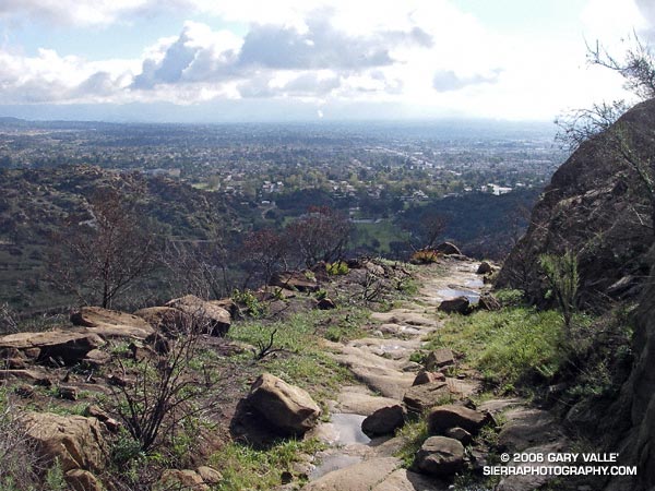
Running or hiking up the Old Santa Susana Stage Road, if you stop and listen carefully, you may hear a sharp whistle, a raspy shout, or a few choice expletives echoing from the canyon walls. It would have taken a barrage of such oaths, and a lot more, to get a stage up and over this harrowing grade.
The image of the Simi Pacific Coast Stage in the book Simi Valley: A Journey Through Time, helps to complete the mental picture. Steep, narrow, and unforgiving, the Stage Road must have produced stark terror in more than a few passengers.
Established in 1861, the “Devil’s Slide” stage road was a link in the Pacific Coast Stage Line between Los Angeles and San Francisco. It follows the route of the original Spanish trail connecting the San Fernando and Santa Buenaventura Missions. Prior to the arrival of the Spanish, the route is said to have been “an old Indian trail,” connecting Chumash communities in Simi Valley to Gabrielino communities in the San Fernando Valley.
Old Santa Susana Stage Road is located in Santa Susana Pass State Historic Park. The park was created in 1998 to protect the Stage Road and other cultural resources in the area. A General Plan characterizing the purpose and long-term vision for the park is in under development, and through a series of meetings, public input on the plan is being requested. The second such meeting is scheduled for Tuesday, June 20, 2006 at 8:30 P.M. at Chatsworth Park South. See the General Plan web page for additional details.
There is currently no “official” trail leading to the Stage Road. Since the area was burned in the Topanga Fire last Fall, it’s important to stay on existing dirt roads and trails to help promote recovery, and avoid damaging sensitive habitat or species.
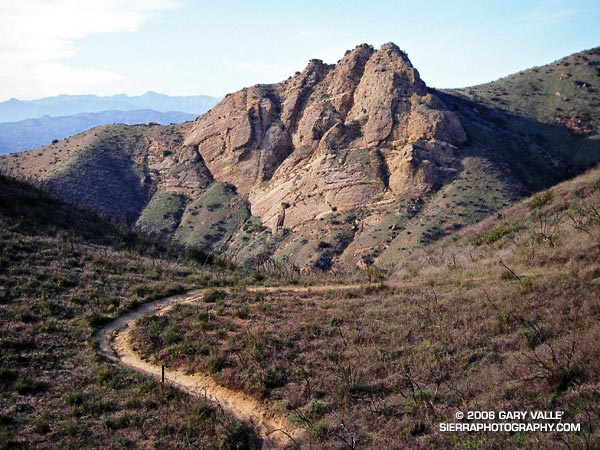
Practically any objective can be a good excuse for an adventure. Each time up or down the Chumash Trail, I pondered the prominent rock formation northwest of the trail and wondered what I might find there.
My first thought was to find a direct route across the deep canyon that parallels the Chumash Trail. Recons from a couple of points on the trail revealed this was a bad idea. Sections of the canyon that looked passable from above were incised, with crumbling, near-vertical walls. A Plan B was required.
A look at a topo map suggested it might be possible to access the formation from Las Llajas Canyon. An advantage of this approach was that, if it worked, it could be part of a loop. On a cool January morning, I decided to give it a go.
From Las Llajas Canyon, an old, overgrown roadbed led up a side canyon to a point where there was no obvious route. The canyon bottom did not look promising, and steep slopes bounded both sides of the canyon. After scrambling several hundred feet up a south-facing slope, I found a deer trail that seemed to be headed in the direction I wanted to go.
This game trail was the key. It reflected the cumulative experience of many deer dealing with the terrain issues I faced. It was remarkably efficient and appeared to be the path that expended the least energy to reach the main ridge. That is, if you’re a deer. At one point, I was forced to backtrack when the trail crossed a steep, exposed slope better suited to those with four legs and cervid hooves.
Chumash Rock
Once on the main ridge, it didn’t take long to reach the rock formation.
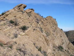
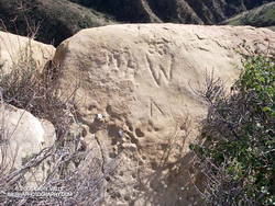
Near the summit of the formation I found some chiseled inscriptions. They were very weathered. The most prominent might be either a “93” or “33” over the top of a “W,” and another is perhaps a “DH.” It’s hard to tell.
Chiseled inscriptions near the summit of Chumash Rock.
Of the three high points comprising the formation, I scrambled to the top of two. The easternmost summit (on the far right when viewed from the Chumash Trail) involved climbing on loose cobble, and looked like an accident waiting to happen. Here’s a photo from the middle tooth, looking down the ridge.
As I climbed down from the summit to a saddle northeast of the rock formation, I spooked a deer, and it bounded into a brush-filled gully.
Continuing up the ridge, it eventually intersected Rocky Peak Rd. at its high point near some bivalve fossil beds. According to the Dibblee map, these are much younger than the rock formation’s cobble and may have been deposited in shallow marine conditions or lagoons a couple million years ago.
At Rocky Peak Rd. I had the option of returning via Las Llajas Canyon but decided to complete the approximately 8-mile route using the Chumash Trail.
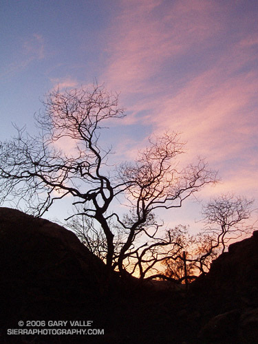
Sunset at Sage Ranch Park, a few weeks following the Topanga Fire. The loop at Sage Ranch is about 2.4 miles. My usual route here is an out and back of about 4.5 miles. It’s a good short-day run with an elevation gain/loss of about 700 ft. (Photo from a run on November 14, 2005.)
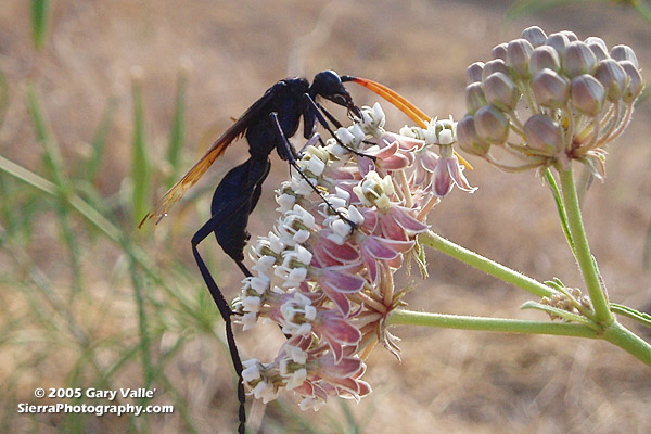
Tarantula Hawks are among the largest of wasps, and are said to have one of the most painful stings of any insect. As chilling as any science fiction, female tarantula hawks hunt, attack and paralyze a tarantula, and then use the spider’s inert — but still living — body as a host for the wasp’s egg and developing larva.
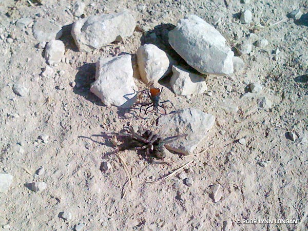
Males have straight antennae, and females curled antennae. This may be because the long, showy antennae of the male would be a serious liability when battling a tarantula. The title photo is of a male on a narrow-leaf milkweed (Asclepias fascicularis) at the start of the Chumash Trail in Simi Valley. Here’s another photo, taken in Las Llajas canyon by runner Lynn Longan, in which a female tarantula hawk has just attacked and paralyzed a tarantula.
Several good runs start at the Chumash trailhead, and many variations are possible. It’s 2.6 miles up the trail to Rocky Peak Rd, and from there you can do out and backs north or south along the fire road, or loops via Las Llajas canyon, the Hummingbird Trail, or the Lower Stagecoach Trail. (Photo from a run on September 14, 2005.)
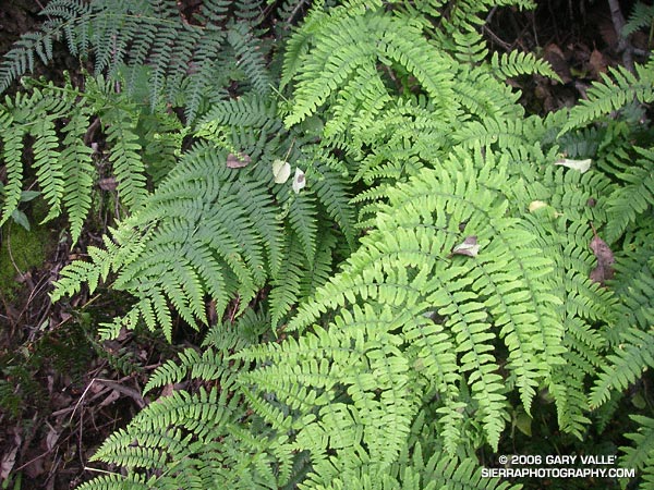
Ferns along the Garapito Trail, Topanga State Park.
Chaparral has been described as an elfin forest, and there is probably no better trail in the Santa Monica Mountains to see why, than the Garapito Trail. From the fire road near Eagle Rock, the trail seemingly dives into a tunnel of chaparral, and doesn’t emerge until it ends at Temescal Fire Road, some 2.5 miles away.
This day I ran a 12 mile figure-eight course from the end of Reseda to Trippet Ranch via the Hub, and then returned via the Musch, Garapito, and Bent Arrow trails. Fire roads out– trails back. A shorter option goes directly to the Garapito Trail via the Hub, and then returns via the Bent Arrow trail. This is about 7.5 miles. A longer option tacks on an out and back to Parker Mesa at Trippet Ranch.