
Just 48 hours before the start of the Diablo Trails Challenge the temperature on Mt. Diablo’s summit was a chilly 31°F. Gray, wind-driven clouds shrouded the summit, propelled by 20-30 mph winds. Over the 10 days preceding the race, it had rained on four, and Concord had received about two inches of rain.
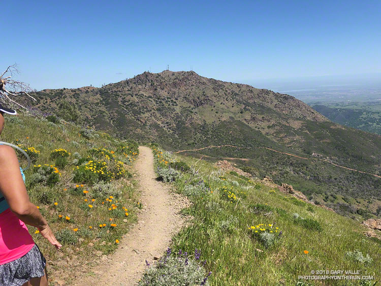
That’s the thing about Spring weather – a couple of days can make a huge difference. Today – race day – the sun is out, the hills are green and skies blue. Very little mud remains – the trails are in great shape and hills sprinkled with wildflowers. It’s the perfect day for a run on Mt. Diablo!
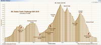
With around 7000′ of elevation gain/loss, the Diablo Trails Challenge 50K is characterized by its many ups and downs. The core of the 50K course is the 7 mile, 3000′ climb from the Curry Canyon Ranch aid station to Diablo’s main summit. But before you can enjoy this fine ascent, you have to get to Curry Canyon Ranch. And it’s on the other side of the mountain – about 12.5 miles away. Here’s a 3D interactive view of my GPS track of the 50K course.
Along the way there are several get-your-feet-wet creek crossings and many hills. Following along on the map, the course works its way past Wall Point, Artist Point, Knob Point and finally Windy Point. Did I mention the course is hilly?
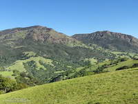
Somewhere around Mile 10 you get the first good view of Mt. Diablo and North Peak. The runner in front of me exclaimed, “Holy guacamole, is that what we are going to climb?” My choice of words were similar, but not quite as polite. Yes indeed, those were the peaks, and they loomed LARGE across the valley.
Elevation gained is so easily lost. After gaining about 2500′ on the way to Windy Point, a 1000′ descent leads to the Curry Canyon Ranch Aid Station. The climb of Diablo starts here, but you really don’t feel like you’re on the mountain until you reach South Gate Road and the Curry Point Aid Station, about three miles up the canyon. The grade in Curry Canyon is moderate and I tried to take advantage of that, knowing steeper terrain was ahead.
The Half-Marathoners joined the course at Curry Point — adding their enthusiasm and company – but they were soon headed back down, leaving us to cope with the Summit Trail all on our own.
“Jalapeño chip?,” I asked the runner hiking up the hill next to me. He smiled and said something like, “Maybe next time.” I did what I could to keep from constantly looking up at the summit. I munched on chips, talked to runners and hikers, read the “Trail Through Time” interpretive signs, looked at wildflowers and enjoyed the great views. As long as you keep putting one foot ahead of the other — and maybe smile from time to time – summits will eventually arrive.
Yahoo! The Summit Aid Station! There is almost no wind. In the sun it’s comfortably warm and in the shade comfortably cool. As at the other aid stations, the volunteers are great, helping me to get my hydration pack sorted and get me on my way. After seven miles of uphill, a little downhill is going to feel really good.
The next few miles I’d done before and they are among the most interesting on the course. It helped to be familiar it – especially the notoriously steep section of North Peak Road, just before the summit. Everyone picks a different route. This time I stayed on the left going up and the right going down, and didn’t fall on my butt!
Once past the “slide” it didn’t take long to get down to Prospector’s Gap. I recalled that the running on the Bald Ridge Trail was excellent and wasn’t disappointed. At Meridian Ridge Road we left Bald Ridge and descended into Mitchell Canyon. At Deer Flat Creek, once again the course headed up. I couldn’t recall how long the climb was going to be, but it looked like we were going to have to work over a high ridge to get to the Castle Rock side of the mountain. The ridge turned out to be Moses Rock Ridge and the climb over it fit right in with the other hills on the course. Click, click goes the elevation-gained counter.
Most of the course is a big loop, but to access the peaks and aid stations there are four short out and back sections. You get to know the runners around you on these sections and we’d give each other encouragement as we passed. The runners around me were great and throughout the run we had many good conversations.
Then there was Burma Road. Somewhere around mile 26, I commented to another runner that we were running out of miles and at some point we were going to have to lose a lot of elevation. The Burma Road descent took care of that.
Many thanks to Jasmin and Sam of Brazen Racing for putting together such a superb event! And a BIG thank you to all the volunteers, ham operators, runners, park staff, sponsors and especially the Save Mount Diablo Foundation. I thoroughly enjoyed running on Mt. Diablo!
Here are a few photos taken along the way. More photos and all the results are available on the Brazen Racing web site.