
Click for an interactive view using Google Earth plug-in.
Update May 29, 2010. Angeles National Forest has issued Forest Order 01-10-02 redefining the Station Fire closure area. See the Angeles National Forest website and this May 29, 2010 post for more info.
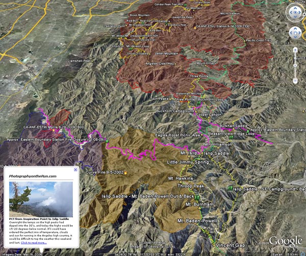
Updated October 7, 2009. Added Sheep Fire Perimeter from GEOMAC and the approximate eastern boundary of the Station Fire Closure Area.
Here’s an interactive Cesium browser View of the approximate areas burned by the Station (2009), Sheep (2009), Morris (2009), Curve (2002), and Williams (2002) fires. The Station, Sheep, and Morris fire perimeters are from the GEOMAC website, and the Curve and Williams perimeters are from the CDF/FRAP website.
The magenta line is the approximate eastern boundary of the Station Fire Closure Area as derived from Angeles National Forest Order No. 01-08-09, Exhibit A and Exhibit B. Please refer to the most current Forest Orders and Exhibits for official information. (See note above, this boundary no longer applies.)
GPS traces of some trail runs inside and outside the Station Fire area have been added, along with links to related photos and stories on PhotographyontheRun.com. Click on the green hiker icon to access the link.
The view also includes a partial track of the Pacific Crest Trail (2009 ver. 1) from the Pacific Crest National Scenic Trail website.
Some placenames have also been added –the locations should be considered approximate.
Related post: Station Fire MODIS Fire Detections