Skiing San Jacinto

Charles Foster on the summit of San Jacinto Peak. San Gorgonio Mountain is in the background.

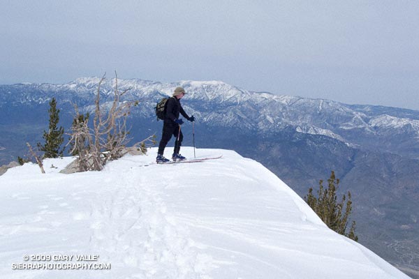
The wind had been blowing in fitful gusts, but calmed as I approached the precipice. Despite its foundation of granite, I felt exposed out on the narrow promontory of snow. Just beyond the tips of my skiis, the north face of San Jacinto Peak dropped 8500 dizzying feet to the desert floor.

The summit of San Jacinto (10,834′) is always spectacular, but with the addition of snow it is transformed into a peak with a high mountain character — a wild and wintry landscape shaped by wind and weather.

Our route to the summit was only four miles long, but with 8 lbs. of ski, boot and binding latched to each foot, the 2400 ft. ascent from the Long Valley ranger station had been strenuous. Rather than following the trail southwest toward Round Valley, we chose to ascend the east-west trending drainage that leads to Tamarack Valley. The steep maze of snow pillows, rocks and trees is a more direct alternative to the well-used Round Valley trail.


Charles Foster works up the scenic east ridge of Mt. San Jacinto. February 21, 2009.
Once out of the maze, we continued west past Tamarack Valley, eventually working up onto the slopes below Miller Peak. From here we switchbacked up the bowl to the saddle between Miller and San Jacinto. From the saddle it was a scenic half mile up the broad east ridge to the summit. Here’s a Google Earth image, a Google Earth KMZ file, and a Cesium ion view of a GPS trace of our route.

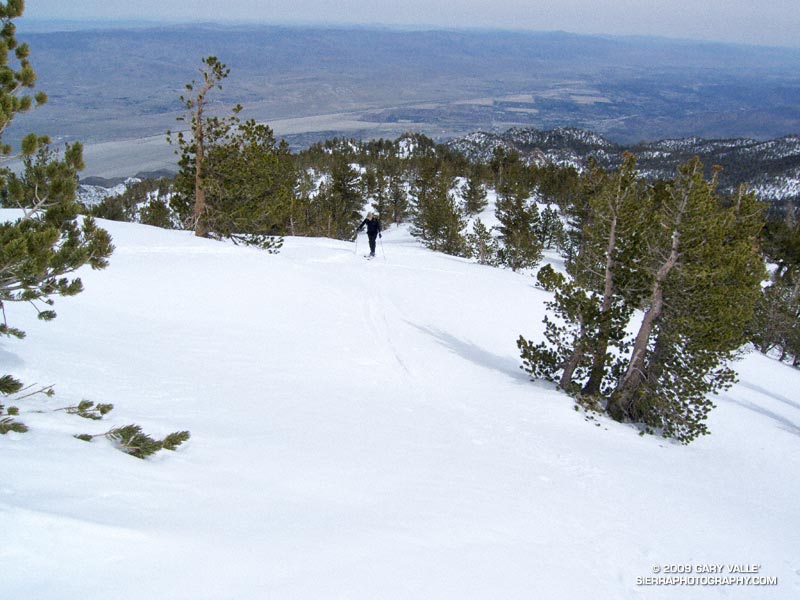
Like any real world mountain, the snow conditions on San Jacinto are not always the best. However, today the snow was pretty good — maybe a 7 or 8 out of 10. It had snowed a few days before, and temps were just starting to warm up. The top 4-5 inches of the pack were dense, and the surface was soft. The sun was muted my a thin veil of high clouds, so the snow did not vary much in and out of the trees.

As we removed our climbing skins and prepared to ski down, Charles and I reminisced about skinny ski descents of San Jacinto, and other peaks. Like sticky rubber on rock climbing shoes, shaped skiis had changed the sport. Easier to manage and turn, shaped skiis handle crud so much better than long, narrow skiis with little side cut.

My initial turns off the summit were a bit tentative, but improved as we skied down through the Lodgepole pines on the east ridge. By the time we dropped into the big bowl southeast of the summit, I was getting my ski legs back, swinging turns, and feeling like it had been 3-4 weeks, rather than 3-4 years, since I had skied here.

Related posts: Room with a View; Rock on Rock, Snow on Snow

Hammering Up the Chumash Trail

Mountain bikers working up the 2.6 mile Chumash Trail.

Mountain bikers working up the 2.6 mile Chumash Trail. Simi Hills and Simi Valley are in the distance. This section of the trail was burned in the Sesnon Fire in October 2008.

Here is a Live Browser View of a GPS trace of the Chumash Trail.

Related post: Chumash Trail Training, Chumash Trail – Sesnon & Simi Fires

Garapito Trail Green

Garapito Trail in Topanga State Park.

Not the green of shamrocks or jade, or an emerald sea,
but of new growth along a trail, softly seen
.

From a run of the Trailer Canyon – Trippet Ranch loop, described in Garapito Trail Runs.

Here is a Live Browser View of the run.

Related post: Ferns Along the Garapito Trail

Shooting Star Seed Capsules

Seed capsules of shooting star (Dodecatheon clevelandii ssp. patulum)

As we’ve seen this Winter, it is the norm for Southern California’s weather to be abnormal. Cool, wet weather in December was followed by weeks of warm, dry weather in January. It is hard to predict when it will be wet and when it will be dry. Especially if you are a plant.

This photograph of a shooting star (Dodecatheon clevelandii ssp. patulum) is from early February, when the weather was dry. Droplets of moisture can be seen clinging to the interior walls of the seed capsules. These climate moderated capsules helps ensure that the plant will produce viable seeds, even if an extended period of dry weather should occur after the plant blooms.

Saddle Peak & Malibu Canyon

Saddle Peak and Malibu Canyon from the Backbone Trail.

Saddle Peak and Malibu Canyon from the Backbone Trail, in the Santa Monica Mountains, near Los Angeles.

According to geologist Thomas Dibblee, Jr., Malibu Creek may be an ancestral stream that predated the uplift of the Santa Monica Mountains. Another possibility, suggested in this technical paper, is that a coastal stream eroded inland, and captured an inland drainage. Such a process may be occurring in Big Sycamore Canyon, which appears to be eroding headward along the Sycamore Canyon Fault, and may eventually capture a drainage in the Potrero Valley.

From Sunday’s run in Malibu Creek State Park.

Malibu Creek State Park Shadow & Sun

Malibu Creek State Park

My trail running shoes had not been wet or muddy since sometime in December. During the entire month of January, Downtown Los Angeles (USC) recorded about one-third of an inch of rain. Not only had it been dry, it had been warm. On a dozen of those January days, the high temperature topped eighty degrees, setting a new record!

But Winter had returned. The past three days, Los Angeles had received about 1.5 inches of rain, valley and foothill locations 2-4 inches, and some mountain stations as much as 5-7 inches. And more Winter weather was on the way. Excited about the change in the weather, today’s run was one with good muck and mire potential — the Bulldog Loop in Malibu Creek State Park.

We were not disappointed. Near Century Lake, mud the consistency of peanut butter pulled at our shoes and slowed the climb up Crags Rd, Further west, near the M*A*S*H site, calf-deep water on the trail washed the gunk off.


Pt. Dume from the Mesa Peak ridgeline.
The trail conditions on the remainder of the loop were more straightforward. From time to time, shafts of sun would pierce the clouds, resulting in a patchwork of shadow and sun that emphasized the rugged terrain. Along the crest, the ocean views were superb! Before descending to Tapia Park we ran out to Mesa Peak, and then followed the ridgeline to an overlook of the coast. (Marked peak 1800 on the topo.)

Including the side trip to the overlook, this variation of the Bulldog loop worked out to an exhilarating 16.5 miles, with an elevation gain/loss of about 2700 ft.

If current forecasts and outlooks for this month hold true, this won’t be our last wet and muddy trail run this February. In a couple of weeks, Los Angeles rainfall totals may climb above normal for the first time this rain season. We’ll see!

Some related posts: Fog Along Malibu Creek, Bulldog Loop and the Corral Fire

Photography and inspiration from running and other adventures in the Open Space and Wilderness areas of California, and beyond. No ads. All content, including photography, is Copyright © 2006-2024 Gary Valle. All Rights Reserved.