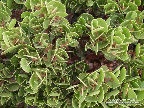
Peculiar pattern in low lying manzanita on the south slopes of Pine Mountain. A friend noted the remarkable similarity of this pattern to that found in gypsum crystals in a desert rose. From the Mt. Baldy North Backbone Trail run/hike.

Peculiar pattern in low lying manzanita on the south slopes of Pine Mountain. A friend noted the remarkable similarity of this pattern to that found in gypsum crystals in a desert rose. From the Mt. Baldy North Backbone Trail run/hike.
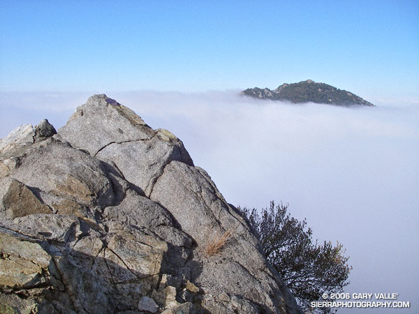
When I broke through the top of the stratus layer, bright sun glared from the jagged granitic rocks along the ridge. To the west, Josephine Peak (5558′) was nearly immersed in an ocean of clouds.
The route I was doing was a variation of the Strawberry Peak Circuit described in the posting Spring Growth. Instead of going around the peak on the Colby Trail, this 13-mile loop climbs up and over Strawberry’s summit (6164′), ascending the class 3 northwest ridge, and then rejoins the circuit at Lawlor Saddle. Although a couple of miles shorter than the circuit around the peak, this route has more elevation gain, and the class 2 and class 3 sections of the ridge require careful route-finding.
Class 2, class 3 – what’s that about? Basically, class 1 is hiking, class 2 is easy scrambling where the hands are used for balance, and class 3 is when the scrambling gets serious, and handholds are required. Another element of class 3 climbing is that staying on route can be important. Deviating from an established route may significantly increase the difficulty or hazard. This is certainly the case on the northwest ridge of Strawberry.
Like much of the San Gabriel Mountains, the rocks of Strawberry Peak are old and fractured. Large landslides have originated from the northwest face of the peak. (The Colby Trail passes through the moraine-like debris of one of these slides.) Because of its friable nature, extra care is required when climbing the northwest ridge. Hand or footholds can break, or footing can be lost on a sandy shelf. Or, as described in a story by pioneering aerodynamicist Paul MacCready, the climber can be trapped in a situation where they cannot climb up or down.
The northwest ridge of Strawberry is by far the most frequently climbed class 3 route in the San Gabriel Mountains. Done with care and appropriate skill, the climbing on the ridge can be an enjoyable and unique experience.
On the summit ridge, I admired the steep northwest face of Strawberry Peak as it plunged through the morning shadows to Strawberry Potrero nearly 1500′ below. Did I hear voices down there, or was it just the wind…
Here are a Google Earth image and Google Earth KMZ file of a GPS trace of the route.
Updated September 19, 2010.
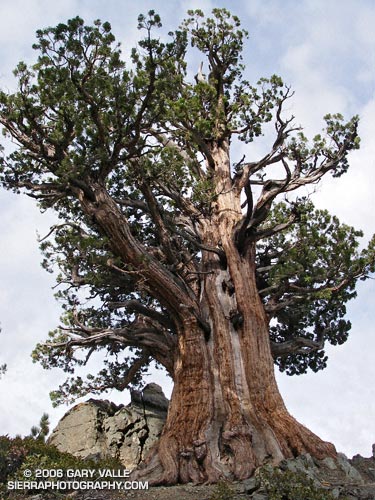
This Sierra Juniper (Juniperus occidentalis var. australis) resides at an elevation of 9000′ on the rocky slopes of Pine Mountain in the Sheep Mountain Wilderness of Southern California. It is an impressive and aged tree. The question is, how old might it be?
Junipers are very slow growing and seem to prefer the dry and difficult conditions that can produce very long-lived trees. Two junipers more than 2000 years old are listed in OLDLIST, a database of scientifically supported tree ages maintained by Rocky Mountain Tree-Ring Research, Inc.
Both of these trees are located in the Sierra near Sonora Pass. OLDLIST lists the age of the Bennett Juniper, a living tree, at an extrapolated age of 2200 years. This estimate is based on a crossdated incremental core. The Scofield Juniper, a tree that died in 1165, has been crossdated at an age of 2675 years.
The Bennett Juniper is a massive tree. The National Register of Big Trees lists its circumference at 481 inches, and height at 78 feet. The juniper on Pine Mountain is not nearly as large, but it is still a sizeable tree.
Update 9/19/2010. I measured the circumference of the Pine Mountain juniper at 14′ 6.5″ or 174.5 inches. This works out to an average diameter of 55.5 inches. The tree is more or less elliptical in cross section, with the major axis aligned along the ridgeline. The tree’s diameter along the major axis is estimated to be 65-70 inches.
If the Bennett Juniper’s diameter is about 153 inches and its age is 2200 years, its average growth in diameter would be 0.0695 inch a year. Applying this same growth rate to the average diameter of the Pine Mountain tree, and its estimated maximum diameter, yields an age range estimate of 800 to 1007 years.
But relative size may not be indicative of relative age. The Pine Mountain Juniper’s shorter rain season and rocky, ridgetop location likely resulted in a slower growth rate than the Bennett tree. The Wally Waldron Limber Pine on nearby Mt. Baden-Powell is estimated to be 1500 years old, and some other Limber Pines on Baden-Powell are thought to be 2000 years old. Whatever its exact age the Pine Mountain Juniper is an extraordinary tree.
The photographs in this post (except for the Wally Waldron tree) were taken on the Mt. Baldy North Backbone Trail and North Backbone Trail Revisited run/hikes.
Some related posts: Inspiration Point to the Pine Mountain Juniper, Mt. Baldy Run Over the Top
Mt. Baldy’s North Backbone Trail is not a place to be in a thunderstorm. From start to finish it seems you are either on the crest of a ridge, or on or near the summit of a peak.
The photo above is of a spiral lightning scar on a Jeffrey Pine on the trail at the summit of peaklet marked 8555 on the USGS Mount San Antonio quad. The scar appears to be fresh, and could be from a strike that occurred this Summer. Perhaps the most remarkable thing, given the tree’s prominent location, is that it hasn’t been struck and scarred before.
The photographs are from Sunday’s North Backbone Trail Revisited hike and run. A photograph of another Jeffrey pine that was struck by lightning can be found in the post Three Points – Mt. Waterman Loop.
Google search: $g(lightning), $g(Jeffrey Pine), $g(lightning tree), $g(North Backbone Trail), $g(Mt. Baldy)
I was cold — but not cold enough to do anything about it. I was chugging up the final steep step on Mt. Baldy’s exposed northern flank and didn’t want to stop. Strong winds were gusting out of the northeast, and the effective temperature had to be in the thirties. Mountain wave clouds paralleled the San Gabriels, stretching in a line from southwest of Mt. Baldy to beyond Mt. Williamson.
At the trailhead I’d seen the lens shaped clouds hovering over the mountains and expected it to be windy and cold. I’d changed my single layer long sleeve top for a more wind resistant double layer top and also pulled on some warmer shorts. I had started the climb with lightweight gloves and a 3 oz. rain shell in my pack. The gloves were out of the pack by the first peaklet, but I was still resisting putting on the rain shell.
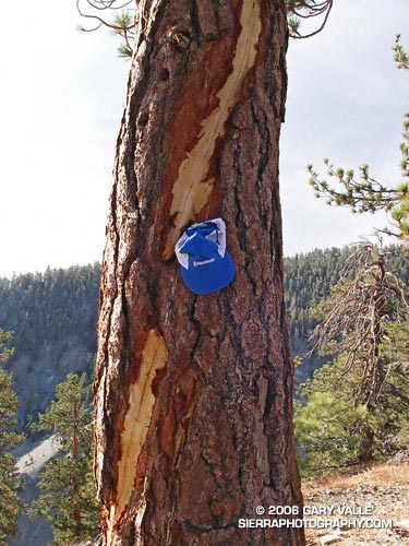
So why repeat the same adventure on back-to-back weekends? The main reason is that I really enjoyed the route. But there were several more obtuse reasons as well. Last week, my Garmin Forerunner 205 would not turn on*. This is a known issue with an otherwise excellent GPS. However the usual workaround, pressing Mode + Reset + Power simultaneously, would not bring mine to life. So I didn’t get a a GPS trace of the route. The trace is not only useful for determining the approximate length of the route and elevation gain, but for documenting where photographs were taken and the location of interesting features.
This week I used my older Garmin Foretrex 201 GPS. It isn’t as compact or comfortable to wear as the Forerunner 205, and isn’t quite as sensitive, but at least it could be powered on. There were two trees in particular that I wanted to georeference. The first was a Jeffrey pine that had been recently struck by lightning. As it turns out, it didn’t require a GPS to determine its location because it is already marked on the topo as point 8555. The second was a gnarled and ancient Sierra Juniper on Pine Mountain.
Here’s a Google Earth image and Google Earth KMZ file of a GPS trace of the route. The title photograph is of a wind swept Jeffrey Pine on a south facing slope near Dawson Peak, with mountain wave clouds in the background.
*Garmin promptly replaced the unit. As a precaution, I now check that the unit can be powered on after it is removed from the recharging cradle.
Some related posts: Mt. Baldy North Backbone Trail, Mt. Baldy Run Over the Top
As I drove under the ski lift on the narrow dirt road, I wondered if I was in the right place. I had turned off of Angeles Crest Highway a few minutes before, and hoped I was still on Blue Ridge Road. My intended destination was an isolated turnout that serves as the trailhead for the North Backbone Trail. This classic trail follows a roller-coaster ridgeline to Mt. Baldy’s broad 10,064′ summit.
Bouncing along the dirt road, I surveyed the sky. The forecast had been for partly cloudy skies, but the morning had dawned overcast and crimson red, and now there was talk of rain. Autumn in the mountains is like that.
The North Backbone Trail is usually not as busy as the usual routes that ascend Mt. Baldy (Mt. San Antonio). One of the reasons is the bumpy six mile, back country drive to the trailhead. Another is the undulating round-trip route gains (and loses) about 4750′ over about eight miles. It climbs over – or nearly over – three highpoints: Point 8555, Pine Mountain (9648′), and Dawson Peak (9575′).
Rounding a corner, I’m surprised to see a small turnout jammed with cars. It’s not hunting season yet, so there must be a group already on the ridge. Squeezing into the last available space, I check that I’m not blocking the road or the car behind me, grab my pack, and jog down the trail to a saddle. To the east Mt. San Jacinto is sandwiched between low clouds and high, and I wonder what the day will bring…
As I reach the summit, the sun breaks through the clouds for the briefest instant. As if driven by my efforts on the ups and downs of the trail, the blues, whites and grays of the sky and clouds have been continuously changing. In turn, the intricacy of the clouds and their motion has energized me. It has been a extraordinary ascent, full of exertion, discovery, wonder, and awe.
A hiker on the summit smiles and waves, and walks over to me. Excited, he tells me that he is 57 and just started climbing peaks two years ago. This is his 57th summit. Days like today are why.
The North Backbone Trail is a treat for the fit and experienced adventurer. In fair weather, and without any snow and ice, it is a strenuous, but relatively straightforward climb. The ups and downs are generally quite steep and there are a few loose, rubbly sections. I hiked the ups, and jogged the flats and downhills. It is not a place to be in a thunderstorm.
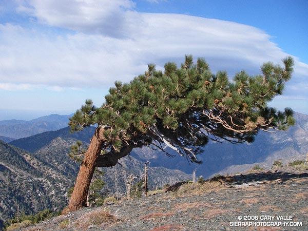
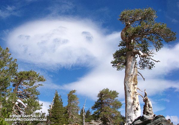
The photograph of a Lodgepole Pine and mountain wave cloud was taken on the slopes of Dawson Peak, on my way back from Mt. Baldy. About an hour later, as I descended from Peak 8555, it started to rain. Autumn in the mountains is like that.
Here’s a Google Earth image of a GPS trace of the route from North Backbone Trail Revisited.
Some related posts: Mt. Baldy Run Over the Top, Pine Mountain Juniper, Mt. Baldy Runner