Western Rim of Boney Mountain

Western rim of Boney Mountain

The plan had been to do a run similar to last week’s Serrano Valley run, with more of an emphasis on distance, than elevation gain. As I worked up the long switchbacks on the Old Boney Trail I debated the benefits and disadvantages of more — or less — elevation gain. Just two weeks before the Bandit 50K would additional elevation gain hurt or help in that hilly race?


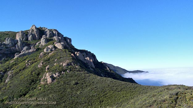
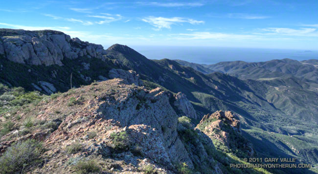
It really didn’t matter. Now was now, and the race was a distant two weeks away. The route up the westernmost of Boney Mountain’s two north ridges was one of my favorites — especially when the weather was clear and the views from the mountain were far reaching. I’d done the Old Boney Trail last week. This week I’d hang a left at the ridge and go up and over the peak.

Anticipating a warm day I’d left my pull-on sleeves in the car. Bad choice. Strong Santa Ana winds scoured the ridge, and the weak morning sun was lukewarm at best. The thick chaparral and tall rock formations provided some protection from the wind, but from time to time the trail would emerge onto a rocky prominence or exposed ridge and remind me just how cold 60 degrees can be!


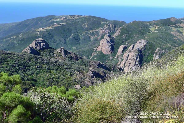
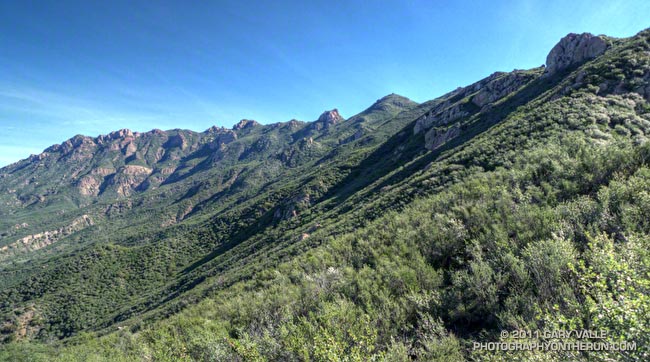
Contrary to experience, the wind moderated a little as I worked up the ridge. It was still very windy, but the buffeting winds I’d expected at the saddle north of Tri Peaks didn’t happen. Even so, it felt great to work around the east side of Tri Peaks and into the full sun on the south side of the peak! The change in the “feels like” temperature must have been 25 degrees! It would be shorts and short-sleeves comfortable for the remainder of the run.

As it turned out the elevation gain going up and over Boney Mountain and down the Chamberlain Trail wasn’t that much more than the up, down, up route along the Old Boney Trail — and the running was oh so good down the recently repaired Chamberlain/Backbone trail!

Some related posts: Boney Mountain Morning, Conejo Valley Sun and Boney Mountain Clouds

Satwiwa Shadows & Sun

Satwiwa from Danielson Rd.

By the time I reached Rancho Sierra Vista/Satwiwa at the end of last Sunday’s wet run to Serrano Valley and back, the frontal band was mostly done with its showers and was speeding to the east. In its wake were blustery winds, broken clouds, and a dynamic patchwork of sun and shadow on Satwiwa’s spectacularly green landscape.

Showery Sunday

Boney Mountain from the Old Boney Trail

Boney Mountain from the Old Boney Trail

It started to sprinkle as I walked from my car to the Wendy Drive trailhead. In a matter of minutes the sprinkles turned to a light, but steady rain, and the Satwiwa trail started to become slick with mud. The rainy weather would continue through most of my run in Pt. Mugu State Park.


It was wet today, but today’s rain was the first in Southern California in nearly a month. Southern California was very wet from October through December, but the storm door from the Pacific into California slammed shut in early January. The weeks of wet weather followed by weeks of warm, dry weather has the plant communities of the Santa Monica Mountains thinking it’s Spring.

Among the flowers blooming along the Old Boney and Serrano Valley trails were paintbrush, encelia, milkmaids, phlox, shooting star, nightshade, wild cucumber, canyon sunflower, deerweed, and bigpod ceanothus. But more than the plants have responded. On January 17, trail runner Howard Cohen took this video of a sizable rattlesnake on the Old Boney Trail!

Some related posts: Serrano Valley from Wendy Drive, Serrano Valley from the Chamberlain Trail

Clouds and Crags

The clouds are in the Conejo Valley and the crags are a prominent highpoint on the ridge that tops the west face of Boney Mountain. Here’s a Google Earth aerial view SSE along the ridge that shows the topography. From the upper cliffs the west face drops over 2000′ to the Backbone Trail in Blue Canyon.


Ascending the western ridge, or easier eastern ridge, is an adventurous way to access the Backbone Trail from Wendy Dr. Once over Tri-Peaks and on the Backbone Trail several loop variations are possible. These range from a relatively direct return on the Boney Trail, to lengthy excursions to Serrano Valley or La Jolla Valley.

Today’s variation worked out to about 20 miles. Once on the upper section of the Backbone Trail, I followed it west down the Chamberlain, Boney and Blue Canyon trails to the Danielson Multi-use area in Sycamore Canyon. After doing a circuit in Sycamore Canyon I picked up the Upper Sycamore Trail and headed back to Danielson Road, Satwiwa, and the trailhead at Wendy Drive.

Some related posts: Boney Mountain Western Ridge & Loop, Sandstone Peak from Wendy Drive, Boney Mountain North Side Loop

The Best Kind of Training

Crags below the Backbone Trail

The great view confirmed it — we had run uphill. The new section of the Backbone Trail was so well-graded that the 850 feet of elevation gain from the trailhead at Encinal Canyon Rd. seemed almost effortless. For the next 14 miles, we would run through one of the most scenic areas of the Santa Monica Mountains; a rough and rugged highland with a character that might put it halfway around the world, rather than 35 miles from downtown Los Angeles.


Mariposas
On this May Day morning, the canyons were cool, the sun warm, and the skies clear. From the craggy heights views extended from Catalina to the Channel Islands; and from Topa Topa to the San Gabriel Mountains. Winter rains had produced a profusion of wildflowers, accenting the trails with the whites, blues, yellows and reds of Spring.

It was an extraordinary day in which mile after mile of trail would pass underfoot with surprising ease. It was the best kind of training — a run in which the training was an afterthought, and the focus was on the experience, rather than the logbook.

Here’s an interactive Cesium ion view of the 23 mile route from Encinal Canyon Rd. to PCH at Sycamore Canyon. The elevation gain on the run was about 2500 ft., and elevation loss about 3800 ft. Continuing to the Ray Miller trailhead by way of the Wood Vista, Overlook and Ray Miller trails would add about 3 miles and another 1000 ft. of gain. Another option would be to run through Serrano Valley to Sycamore Canyon. The Fireline Trail is a short distance down canyon from the Serrano Valley Trail, and could also be used to link to the Overlook and Ray Miller trails.

And here’s a photo of the Yerba Buena segment of the Backbone Trail when it was under construction in 2003.

Related post: Boney Mountain Crags

Fossil Trail – Pt. Mugu State Park

Shell impressions on the Fossil Trail in Pt. Mugu State Park.

The Fossil Trail is a steep, approximately mile-long trail in Pt. Mugu State Park that connects the Upper Sycamore Trail, near its junction with Sycamore Canyon Road, to the Old Boney Trail. The most obvious fossils are shell impressions and remnants found in an exposed layer of sandstone about a tenth of a mile below the Old Boney Trail junction. Some of the shell impressions are palm-sized and larger.

The shells appear to be a type of cockle (Anadara devincta) that is an indicator of Miocene-age formations. (See the Oregon Sea Grant publication “Fossils You Can Find on Oregon Beaches.“)  In this case, the fossil exposure appears to be in the Lower Topanga Formation, which is believed to have been formed in the middle to early Miocene, about 20 million years ago.

The shape, thickness and ribbing of this type of shell increases its strength and resistance to crushing — improving the shell’s chances of remaining intact when buried in sediment, and during subsequent geologic processes. This may be one of the reasons it is a prevalent indicator fossil.

The photograph is from Sunday’s run from Wendy Drive to Serrano Valley.