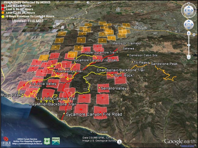
Springs Fire MODIS fire detections as of 05/03/13 1115 MDT
Update May 13, 2013. According to the CAL FIRE website the Springs Fire was 100% contained on May 11 at 24,251 acres. The interactive Google Earth browser view of the Springs fire perimeter has been updated with the fire perimeter from GEOMAC timestamped 05/07/13 0348. This is a 3D view that can be zoomed, rotated and tilted. Placemark locations are approximate. GPS tracks from various runs have been added to mark many of the area’s trails. The red track is Sycamore Canyon Fire Road. Requires Google Earth plugin.
Today SMMNRA announced that some areas closed by the Springs Fire will reopen tomorrow morning. Rancho Sierra Vista in Newbury Park will partially reopen, the Sandstone Peak and Mishe Mokwa trailheads will reopen, and the Backbone Trail east of the Point Mugu State Park boundary will reopen. Also, see the SMMNRA news release After the Fire: 3 Things You Can Do to Help Nature Recover and the SMMNRA Photostream on Flickr.
Previous snapshots:
Springs Fire fire perimeter from GEOMAC timestamped 05/06/13 0555.
Springs Fire fire perimeter from GEOMAC timestamped 05/03/13 2345.
Springs Fire MODIS fire detections as of 05/04/13 1315 MDT with GEOMAC fire perimeter timestamped 05/03/13 2345.
Springs Fire MODIS fire detections as of 05/04/13 0800 MDT.
Springs Fire MODIS fire detections as of 05/03/13 2215 MDT.
Springs Fire MODIS fire detections as of 05/03/13 1700 MDT.
Springs Fire MODIS fire detections as of 05/03/13 0845 MDT.
MODIS Google Earth fire data is from the USDA Forest Service Remote Sensing Applications Center Active Fire Mapping Program web site. Fire perimeter is the most recently available from the GEOMAC website at the time this post was updated.
The following additional information was included with the MODIS fire detections KML file:
This KML displays the MODIS fire detections at a spatial resolution of 1km for the past 6 hours, 6-12 hours, 12-24 hours, and the previous 6 day period. Each 1km MODIS fire detection is depicted as a point representing the centroid of the 1km pixel where the fire is detected. The 1km footprint of the MODIS pixel for each detection is also displayed.
KML file generated by the USDA Forest Service Active Fire Mapping Program.
Disclaimer: Although these data have been used by the USDA Forest Service, the USDA Forest Service shall not be held liable for improper or incorrect use of the data described and/or contained herein. The information contained in these data is dynamic and is continually updated. This disclaimer applies both to individual use of the data and aggregate use with other data. The USDA Forest Service reserves the right to correct, update or modify this data and related materials without notification.
