
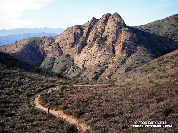
Practically any objective can be a good excuse for an adventure. Each time up or down the Chumash Trail, I pondered the prominent rock formation northwest of the trail and wondered what I might find there.
My first thought was to find a direct route across the deep canyon that parallels the Chumash Trail. Recons from a couple of points on the trail revealed this was a bad idea. Sections of the canyon that looked passable from above were incised, with crumbling, near-vertical walls. A Plan B was required.
A look at a topo map suggested it might be possible to access the formation from Las Llajas Canyon. An advantage of this approach was that, if it worked, it could be part of a loop. On a cool January morning, I decided to give it a go.
From Las Llajas Canyon, an old, overgrown roadbed led up a side canyon to a point where there was no obvious route. The canyon bottom did not look promising, and steep slopes bounded both sides of the canyon. After scrambling several hundred feet up a south-facing slope, I found a deer trail that seemed to be headed in the direction I wanted to go.
This game trail was the key. It reflected the cumulative experience of many deer dealing with the terrain issues I faced. It was remarkably efficient and appeared to be the path that expended the least energy to reach the main ridge. That is, if you’re a deer. At one point, I was forced to backtrack when the trail crossed a steep, exposed slope better suited to those with four legs and cervid hooves.
Once on the main ridge, it didn’t take long to reach the rock formation.
According to the Dibblee geologic map of the area, the formation is positioned on the south branch of the Simi Fault. The steeply inclined layers of cobble that are embedded in the formation might have been deposited as part of a fan delta some 60 million years ago. This cobble is also encountered at several places along the Chumash Trail.
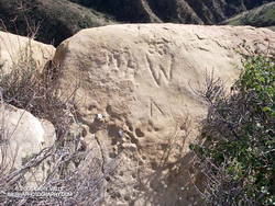
Near the summit of the formation I found some chiseled inscriptions. They were very weathered. The most prominent might be either a “93” or “33” over the top of a “W,” and another is perhaps a “DH.” It’s hard to tell.
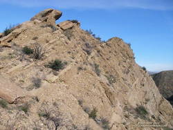
Of the three high points comprising the formation, I scrambled to the top of two. The easternmost summit (on the far right when viewed from the Chumash Trail) involved climbing on loose cobble, and looked like an accident waiting to happen. Here’s a photo from the middle tooth, looking down the ridge.
As I climbed down from the summit to a saddle northeast of the rock formation, I spooked a deer, and it bounded into a brush-filled gully.
Continuing up the ridge, it eventually intersected Rocky Peak Rd. at its high point near some bivalve fossil beds. According to the Dibblee map, these are much younger than the rock formation’s cobble and may have been deposited in shallow marine conditions or lagoons a couple million years ago.
At Rocky Peak Rd. I had the option of returning via Las Llajas Canyon but decided to complete the approximately 8-mile route using the Chumash Trail.
This interactive, 3D terrain map shows the approximate route used to get to Chumash Rock and then complete the loop. The hike/run was on January 29, 2006.